| مطوّر البرامج: | Air Navigation SA (1) | ||
| السعر: | * مجاني | ||
| لتصنيفات: | 0 | ||
| المراجعات: | 0 أكتب مراجعة | ||
| قوائم: | 0 + 1 | ||
| النقاط: | 0 + 4,371 ¡ | ||
| النقاط + 1 | |||
الوصف
")
- Everything you need to fly around the world
- Plan your flight in a few minutes
- Fly relaxed with up-to-date information
Air Navigation Pro is a high-quality flight assistant app for pilots worldwide. Benefit from the following main features:
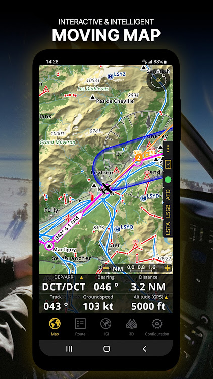
MOVING MAP
Plan and navigate using our interactive moving map. Choose between aeronautical charts, satellite or our vector map as a background. On top of that, the moving map displays waypoints, NOTAM, obstacles and airspaces from our comprehensive, always up-to-date worldwide aeronautical database. Tap on any waypoint directly on the map to easily create a route. Personalize the values shown on the navbar to have exactly the information you need: altitude, vertical speed, bearing, distance to the next waypoint, ETA calculations, etc. Choose the airport departure and arrival procedures for your route to have them also displayed on top of the moving map.
ENHANCED TRAFFIC AWARENESS
Get visual and audio alerts in all languages for nearby conflicting traffic. Choose your preferred traffic icon between generic, aircraft or TCAS symbols. Your safety is important to us, which is why we partnered with SafeSky to ensure our users have live traffic data during their flight. Benefit from the native integration with SafeSky included in our new Smart Lite, Smart Classic and Smart Advanced subscriptions—a two-in-one package!
ADVANCED WEATHER LAYERS
In addition to the basic weather reports of winds and TAF/METAR for your flight, subscribers of the Smart Advanced plan can activate see-through weather layers on top of the moving map. Available layers include rain radar, wind, pressure, clouds and rain, visibility, gust and additionally for Germany, Switzerland, Austria and the Balkans, GAFOR reports. Tap on any point on the map to see the weather information for that area. Review the weather forecast for up to three days ahead.
NOTAM
After creating your route, set the departure time in the future to have the moving map display the NOTAM active for that specific time. NOTAM on the map change color dynamically based on their status.
SMARTCHART
Our cutting-edge SmartChart is a highly detailed and intelligent vector-based map that adapts to your needs, providing you with adequate information at any zoom level. The SmartChart optimizes the display of shadows to easily distinguish between valleys and mountains, and the text remains perfectly aligned, guaranteeing optimal readability. Including the latest significant improvements with forests and detailed airport information.
ELEVATION PROFILE & SYNTHETIC VIEW
Enable the profile view below the navbar for enhanced situational awareness of the elevation ahead of you or along your route. Choose the corridor width between 0 to 5 NM and overlay options: airspaces, NOTAM, obstacles, wind components, populated places, etc. Switch to the synthetic view for additional terrain information, plus an artificial horizon with altitude and vertical speed indicators. This function can also be used to pan around while preparing for your flight. Activate TAWS on the moving map as well as on the synthetic view.
AERONAUTICAL CHARTS & APPROACH CHARTS
We offer the most extensive worldwide catalog of aeronautical charts, including the ICAO charts. Have the georeferenced approach charts displayed on top of the moving map or the synthetic view.
BRIEFING
Prepare your flight with our briefing section by creating documents with NOTAM and weather charts & stations relevant to your planned route. Optimize time by creating an aircraft profile which will be used in the Briefing section to pre-fill for you the ATC Flight Plan and calculate the W&B.
AND SO MUCH MORE!
A subscription allows you to use the app on three devices. We recommend creating an Air Navigation account for improved device management. Refer to our user manual on our website: www.airnavigation.aero for more information.
لقطات


فيديو
الميزات الجديدة
- الإصدار: 8.3.370.404160509
- تم التحديث:
- -Presenting Synthetic View: upgraded 3D View, featuring improved UI and Moving Map preview!
-New Map Advanced Visibility Settings: set custom zoom levels for seamless transitions between overlapping maps
-Enhanced Satellite Imagery: Smart Advanced subscribers get high-quality views on higher zoom levels, while all Smart plans gain access for free to regional topographical and satellite tile servers
السعر
-
*عمليات الشراء داخل التطبيق - اليوم: مجاني
- الحد الأدنى: مجاني
- الحد الأقصى: $23.42
تتبّع الأسعار
مطوّر البرامج
- Air Navigation SA
- المنصات: Android تطبيقات (1)
- قوائم: 0 + 1
- النقاط: 0 + 4,371 ¡
- لتصنيفات: 0
- المراجعات: 0
- تخفيضات: 0
- أشرطة فيديو: 1
- RSS: اشتراك
النقاط
غير معثور عليه ☹️
لتصنيفات
غير معثور عليه ☹️
قوائم
غير معثور عليه ☹️
المراجعات
كن الأول لمراجعة هذا المنتج!
معلومات إضافية
- الفئة:
Android تطبيقات›الخرائط والتنقل - نظام التشغيل:
Android 7.1 والأحدث - الحجم:
25 Mb - تقييم المحتوى:
Everyone - Google Play تقييم:
3.3(4,371) - تم التحديث:
- تاريخ الإصدار:
جهات الاتصال
- الموقع الإلكتروني:
 https://www.airnavigation.aero
قد يعجبك ايضا
-
- Marine Navigation Lite
- Android تطبيقات: الخرائط والتنقل بواسطة: Marco Palaferri
- * مجاني
- قوائم: 0 + 0 لتصنيفات: 0 المراجعات: 0
- النقاط: 0 + 2,354 الإصدار: 8.4.27 MARINE NAVIGATION Find your road on the sea! GPS chartplotter for boating. An easy-to-use offline GPS tracker and route planner featuring worldwide offline maps. Navigate with your ...
-
- GPS Navigation, Maps & Traffic
- Android تطبيقات: الخرائط والتنقل بواسطة: Green Mobile Studios
- * مجاني
- قوائم: 0 + 0 لتصنيفات: 0 المراجعات: 0
- النقاط: 0 + 2,174 الإصدار: 2.0 Best Maps & Navigation with Driving Directions, Live Traffic Updates, Live Weather Updates, Transit Info gives you distance and time (duration) to your destination while you are ...
-
- King Compass 2024
- Android تطبيقات: الخرائط والتنقل بواسطة: Battery Stats Saver
- * * مجاني
- قوائم: 0 + 0 لتصنيفات: 0 المراجعات: 0
- النقاط: 0 + 4,693 الإصدار: 2.11.0.1 Compass King: The Ultimate Digital Compass Have you ever found yourself lost in a new city or hiking in the great outdoors without a direction compass? Maps will become obsolete! My ...
-
- GPX Viewer PRO
- Android تطبيقات: الخرائط والتنقل بواسطة: Vectura Games OÜ
- * $8.99
- قوائم: 3 + 0 لتصنيفات: 0 المراجعات: 0
- النقاط: 0 + 7,105 الإصدار: 1.46.1 View gpx, kml, kmz, loc files, but get a lot more features. See why we are one of the best rated offline vector maps app. GPX Viewer PRO is the ultimate GPS locator, GPS tracks viewer,
-
- BICYCLE NAVITIME
- Android تطبيقات: الخرائط والتنقل بواسطة: NAVITIME JAPAN CO., LTD.
- * مجاني
- قوائم: 0 + 0 لتصنيفات: 0 المراجعات: 0
- النقاط: 0 + 11,320 الإصدار: New Bicycle NAVITIME is a cycling app that can be used all across Japan. It has both English and Chinese (Traditional and Simplified) language support. Features with multi-language support
-
- SkyDemon
- Android تطبيقات: الخرائط والتنقل بواسطة: Divelements Limited
- مجاني
- قوائم: 0 + 0 لتصنيفات: 0 المراجعات: 0
- النقاط: 0 + 2,584 الإصدار: 3.16.13 SkyDemon is one of Europe's most popular solutions for VFR flight planning and in-flight navigation. Use this app to access your SkyDemon subscription on your Android device, unlocking
-
- NISSAN Driver's Guide
- Android تطبيقات: الخرائط والتنقل بواسطة: Nissan Europe
- مجاني
- قوائم: 0 + 0 لتصنيفات: 0 المراجعات: 0
- النقاط: 0 + 4,057 الإصدار: 3.0.12 The Nissan Driver s Guide is an application based on Augmented Reality Technology. It will help you to learn and understand more about your vehicle. The application is available for ...
-
- Geographica [Offline GPS APP]
- Android تطبيقات: الخرائط والتنقل بواسطة: keiziweb
- * * مجاني
- قوائم: 0 + 0 لتصنيفات: 0 المراجعات: 0
- النقاط: 0 + 1,816 الإصدار: 2.0.51 - Geographica: GPS map app which can use even offline. Geographica is a [Map Caching Offline GPS app] for mountaineering. Once you viewed a map image on the screen, that will be stored
قد يعجبك ايضا
- Android تطبيقات
- جديد Android تطبيقات
- الخرائط والتنقل Android تطبيقات : جديد
- أشرطة فيديو Android تطبيقات
- أعلى Android تطبيقات
- الخرائط والتنقل Android تطبيقات : أعلى
- تخفيضات Android تطبيقات
- الخرائط والتنقل Android تطبيقات : تخفيضات
- لتصنيفات Android تطبيقات
- المراجعات Android تطبيقات
- قوائم Android تطبيقات
- النقاط Android تطبيقات