| Προγραμματιστής: | Gaman Grp LLC (3) | ||
| Τιμή: | $4.99 | ||
| Κατατάξεις: | 0 | ||
| Κριτικές: | 0 Γράψτε μια κριτική | ||
| Λίστες: | 0 + 0 | ||
| Βαθμοί: | 0 + 0 ¡ | ||
| Google Play | |||
Περιγραφή
")
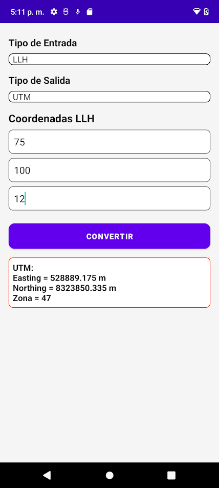
Unlock the full potential of your geographic data with Coordinate Converter UTM-ECEF-LLH—the ultimate Android app designed for precision, versatility, and ease of use. Whether you're a surveyor, geospatial professional, or GNSS enthusiast, this app ensures seamless transformations between major coordinate systems like UTM (Universal Transverse Mercator), LLH (Latitude, Longitude, Height), and ECEF (Earth-Centered, Earth-Fixed).
Key Features:
🌍 Accurate Coordinate Conversion: Transform your geospatial data effortlessly between UTM, LLH, and ECEF formats with unparalleled accuracy. Designed for professionals who demand precision in mapping, land surveying, and geodetic applications.
📍 UTM Zone Automation: Automatically detect UTM zones based on latitude and longitude for faster, error-free results. Simplify calculations for large-scale GIS projects.
📐 Geodetic Accuracy: Built with industry-standard algorithms to ensure results compatible with the most precise GNSS systems, including those used in topography and engineering.
🗺️ Simple Yet Powerful Interface: The intuitive design makes it easy to input, convert, and review coordinate data in a matter of seconds. Tailored for both experts and students in the geospatial field.
🎯 Designed for Professionals: Ideal for surveyors, GIS analysts, cartographers, and engineers. Use it for land planning, geodetic positioning, and satellite tracking.
🔑 Offline Functionality: No need for an internet connection—work anytime, anywhere, even in remote locations.
🔄 Multi-Coordinate Support: Convert between UTM, LLH, and ECEF seamlessly, ensuring compatibility across diverse software and hardware platforms.
💡 Why Choose Coordinate Converter UTM-ECEF-LLH? This app stands out for its precise algorithms, optimized workflows, and focus on the needs of surveying and mapping professionals. Whether you're navigating complex geospatial data, performing RTK corrections, or analyzing geographic positions, this tool ensures your data is always accurate and reliable
Ad
Στιγμιότυπα οθόνης


Τι νέο υπάρχει
- Εκδοχή: 1.0
- Ενημερώθηκε:
- Release Notes - Version 1.0
Introducing Coordinate Converter: UTM-ECEF, the ultimate tool for transforming coordinates between the most common geodetic systems:
LLH (Latitude, Longitude, Height)
UTM (Universal Transverse Mercator)
ECEF (Earth-Centered, Earth-Fixed)
Key Features:
Input coordinates in your preferred format and convert them effortlessly.
Seamless support for hemisphere and altitude adjustments.
Τιμή
- Σήμερα: $4.99
- Ελάχιστο: $4.99
- Μέγιστο: $4.99
Παρακολούθηση τιμών
Ad
Προγραμματιστής
- Gaman Grp LLC
- Πλατφόρμες: Android Εφαρμογές (3)
- Λίστες: 0 + 0
- Βαθμοί: 0 + 0 ¡
- Κατατάξεις: 0
- Κριτικές: 0
- Εκπτώσεις: 0
- Βίντεο: 0
- RSS: Εγγραφή
Βαθμοί
0 ☹️
Κατατάξεις
0 ☹️
Λίστες
0 ☹️
- Coordinate converter: UTM-ECEF
Κριτικές
Γίνε ο πρώτος που θα αξιολογήσει 🌟
Πρόσθετες πληροφορίες
- Εκδοχή: 1.0
- Κατηγορία:
Android Εφαρμογές›Χάρτες και πλοήγηση - Λειτουργικό σύστημα:
Android 5.0 - Μέγεθος:
21 Mb - Αξιολόγηση περιεχομένου:
Everyone - Google Play Εκτίμηση:
0 - Ενημερώθηκε:
- Ημερομηνία έκδοσης:
- 🌟 Κοινή χρήση
- Google Play
Μπορεί επίσης να σας αρέσει
-
- Coordinate Converter Plus
- Android Εφαρμογές: Χάρτες και πλοήγηση Με: Tennyson Chingombe
- * * Δωρεάν
- Λίστες: 0 + 0 Κατατάξεις: 0 Κριτικές: 0
- Βαθμοί: 1 + 562 (4.1) Εκδοχή: 187 Coordinate Converter Plus is a coordinate converter and elevation calculator for Android. Supported coordinate formats: 1 Latitude / Longitude: - Decimal degrees (DD.ddd) - Degrees ... ⥯
-
- Coordinate Me
- Android Εφαρμογές: Χάρτες και πλοήγηση Με: Apps for Causes LLC
- Δωρεάν
- Λίστες: 0 + 0 Κατατάξεις: 0 Κριτικές: 0
- Βαθμοί: 0 + 0 Εκδοχή: 1.2.0 Coordinate Me is the comprehensive location utility that puts precise positioning at your fingertips: CORE FEATURES: Get your exact GPS coordinates instantly View location accuracy in ... ⥯
-
- UTM MGRS Map
- Android Εφαρμογές: Χάρτες και πλοήγηση Με: GVN Apps
- * * Δωρεάν
- Λίστες: 0 + 0 Κατατάξεις: 0 Κριτικές: 0
- Βαθμοί: 0 + 191 (3.4) Εκδοχή: 81 Features; - Map for off-road activities - Multiple coordinate types(UTM, MGRS, LAT LONG) - Operation/Activity planning - Sharing scheduled recordings - Export scheduled recordings - ... ⥯
-
- UTM Map
- Android Εφαρμογές: Χάρτες και πλοήγηση Με: Edip Ahmet Taskin
- * Δωρεάν
- Λίστες: 0 + 0 Κατατάξεις: 0 Κριτικές: 0
- Βαθμοί: 0 + 155 (4.4) Εκδοχή: 16.2 UTM Map displays latitude - longitude, MGRS and UTM X,Y coordinates on the map. You can see your coordinates or you can get coordinates of any place on the map. User can see the ... ⥯
-
- Coordinate Joker
- Android Εφαρμογές: Χάρτες και πλοήγηση Με: siggel-apps
- Δωρεάν
- Λίστες: 0 + 0 Κατατάξεις: 0 Κριτικές: 0
- Βαθμοί: 0 + 0 Εκδοχή: 1.4.42 Coordinate Joker is a Geocaching Add-on for application Locus Map, but works also with other apps that can display waypoints from a gpx, kml, or kmz file. Finally you made it to the ... ⥯
-
- Coordinate
- Android Εφαρμογές: Χάρτες και πλοήγηση Με: TUSHAR SHELAR
- * Δωρεάν
- Λίστες: 0 + 0 Κατατάξεις: 0 Κριτικές: 0
- Βαθμοί: 0 + 0 Εκδοχή: 1.0 Precision Field Planning at Your Fingertips. Stop struggling with clunky interfaces. Our app provides high-performance mapping tools specifically built for field professionals. ... ⥯
-
- UTM Geo Map
- Android Εφαρμογές: Χάρτες και πλοήγηση Με: Y2 Tech
- * * Δωρεάν
- Λίστες: 0 + 0 Κατατάξεις: 0 Κριτικές: 0
- Βαθμοί: 1 + 22,085 (4.8) Εκδοχή: 4.3.05 Complete, simple, easy to use & free application for Land Surveying, Topography, Bathymetry & GIS. Suitable for Geodesy Engineering, Civil Engineering, Geology and other disciplines ... ⥯
-
- Coordinates Converter: GPS Map
- Android Εφαρμογές: Χάρτες και πλοήγηση Με: brandingtechstudio
- * Δωρεάν
- Λίστες: 0 + 0 Κατατάξεις: 0 Κριτικές: 0
- Βαθμοί: 0 + 0 Εκδοχή: New With the GPS Coordinate Converter app, you can effortlessly convert GPS Coordinates into various coordinate formats, calculate distances in different units, rapidly identify your ... ⥯
-
- Naviation UTM
- Android Εφαρμογές: Χάρτες και πλοήγηση Με: Naviation AB
- Δωρεάν
- Λίστες: 0 + 0 Κατατάξεις: 0 Κριτικές: 0
- Βαθμοί: 0 + 0 Εκδοχή: 1.1.2 Naviation UTM helps manage drone flights safely and in line with EASA standards. The app offers easy-to-use interfaces for pilots, with features like live flight tracking, airspace ... ⥯
-
- KoordKonvert - Coord Converter
- Android Εφαρμογές: Χάρτες και πλοήγηση Με: HWA apps
- * * Δωρεάν
- Λίστες: 0 + 0 Κατατάξεις: 0 Κριτικές: 0
- Βαθμοί: 0 + 0 Εκδοχή: 1.1.2 KoordKonvert The Coordinate Converter App Easily convert between coordinate formats and visualize them on a map with KoordKonvert. Whether you're a hiker, surveyor, soldier or ... ⥯
-
- MGRS, UTM,DMS & ED50 - LUC
- Android Εφαρμογές: Χάρτες και πλοήγηση Με: miavation
- * Δωρεάν
- Λίστες: 0 + 0 Κατατάξεις: 0 Κριτικές: 0
- Βαθμοί: 0 + 0 Εκδοχή: 1.0.7 Welcome to the most comprehensive coordinate tool! LUC offers an advanced coordinate converter supporting dozens of coordinate systems, detailed activity tracking, GeoJSON/KML export, ... ⥯
-
- Vocal Coords (Converter)
- Android Εφαρμογές: Χάρτες και πλοήγηση Με: Eagle Eyes Search
- Δωρεάν
- Λίστες: 0 + 0 Κατατάξεις: 0 Κριτικές: 0
- Βαθμοί: 0 + 0 Εκδοχή: 1.0.5 Vocal Coords Voice-Controlled Coordinate Converter Convert, read, and map coordinates fast. Vocal Coords lets you speak or type any coordinate, converts it instantly, and reads it ... ⥯
-
- Mgrs & Utm Map
- Android Εφαρμογές: Χάρτες και πλοήγηση Με: DakikTech
- * Δωρεάν
- Λίστες: 0 + 0 Κατατάξεις: 0 Κριτικές: 0
- Βαθμοί: 0 + 21,808 (4.6) Εκδοχή: 7.3.6 This application is GPS and coordinate systems helper especially for military personnel. It is also a complete helper for mountaineering, trekking and hiking, cross running, scouting, ... ⥯
-
- Coordinator-Collect Coordinate
- Android Εφαρμογές: Χάρτες και πλοήγηση Με: DER Soft
- * * Δωρεάν
- Λίστες: 0 + 0 Κατατάξεις: 0 Κριτικές: 0
- Βαθμοί: 0 + 2,805 (4.3) Εκδοχή: 7.9.1 Using Coordinator app, you can collect coordinate data from land on whatever coordinate system you want, choosing from defined systems. You can collect GPS coordinates. You can use the ⥯