| مطوّر البرامج: | Disciple Skies Software (32) | ||
| السعر: | * * مجاني | ||
| لتصنيفات: | 0 | ||
| المراجعات: | 0 أكتب مراجعة | ||
| قوائم: | 0 + 0 | ||
| النقاط: | 0 + 43,570 ¡ | ||
| النقاط + 1 | |||
الوصف
")
Turn your phone into a powerful GPS navigation system with Polaris Navigation GPS, the most accurate all-purpose GPS, and dare to go where there are no roads.
Imagine... What would it be like to navigate any waterway or hike any wilderness or city using only your phone's GPS location abilities and a view of the sky? What it would be like to create navigation destinations without the need of an internet connection and find them using offline maps or a waypoint pointing arrow.
That is just a glimpse of the navigational power you will hold in your hands when you install Polaris Navigation GPS.
Used mostly as a hiking, off road, nautical and trail GPS app, Polaris is an excellent backup or replacement for your dedicated GPS satellite navigation unit and will keep you oriented wherever your outdoor adventures take you!
Typical usage:
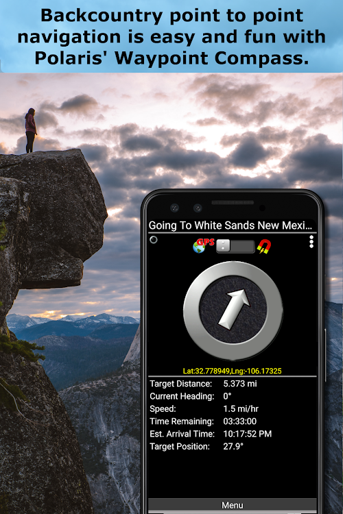
● Waypoint navigation.
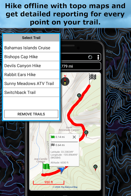
● Hiking GPS with the best hiking maps! Search and find nearby trails.
● Back country exploration and outdoor adventure.
● Record tracks and navigate trails.
● Offroad navigation support for your ATV, Jeep or other 4x4 vehicle.
● Sailing / Boating. All marine navigation charts in Polaris are free.
● Fishing GPS. Easily find you favorite fishing hole.
● Hunting and hunting maps. Find you favorite hunting blind and your way back!
● Geocache
● Camping
● Mountain Biking and bike maps
● Backpacking and other outdoor sports
● Compass orienteering
Known for its stability, reliability and flexibility, Polaris is used by land-sea search and rescue, military personnel and millions of others worldwide.
For your offline adventures we provide:
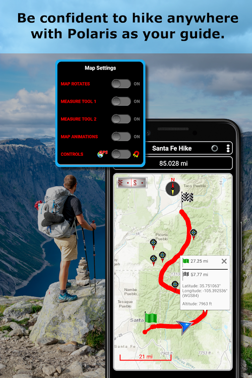
📡 Unlimited free access to our offline vector & raster maps (topographic maps, marine, hiking and others).
📡 Offline nautical charts for the USA included (ENC's and raster).
This powerful navigation system also includes:
📡 Polaris Places Picker. Find hiking trails, camping locations and much more!
📡 GPS compass and magnetic compass.
📡 GPS info panel.
📡 Odometers, altimeters, speedometers, chronometers.
📡 Split distances on tracks.
📡 Connect your waypoints and navigate the track they define.
Map Types:
- Google Maps
- OpenStreetMap-Mapnik
- Topographic Maps
- Cycle Route and Hiking Maps
- Vector Maps
- USGS Topo
- NOAA Marine Charts
- Aviation Operations Charts
- Canada Toporama
📡 Comprehensive set of GPS Tools and diagnostics.
📡 Waypoint navigation system including a dynamic waypoint-finding compass that always points to your destination while reporting estimated time of arrival, distance to target and other statistics. Just follow the arrow!
📡 Trail navigation system
📡 Altitude profiles
📡 Location sharing
📡 Supports British OSGR and OSGB-36 DATUM (Ordnance Survey Grid).
📡 Coordinate formats: latitude/longitude as degrees, deg:min, deg:min:sec, and UTM (Universal Transverse Mercator)
📡 Military Coordinate Finder - Military Grid Coordinate Reference System (MGRS)
📡 Hiking Trails - Most of the maps show hiking paths courtesy of the Openstreetmap project. You will find that even some of the most remote hiking routes are visible on our maps.
⚓ Marine navigation- NOAA Nautical Charts and nautical unit reporting.
⚓ Drift alert / Drag anchor alarm.
📡 Select source for altitude reporting: Satellites, United States Geologic Survey or map your location to the results of NASA's Space Shuttle Radar Topography Mission.
📡 Waypoint photos stamped with coordinates.
📡 Road navigation and street directions are provided through a digital pipeline connecting the power of Polaris to the Google Maps app on your device.
* The premium version of Polaris Navigation is called GPS Waypoints Navigator, available on Google Play. GPS Waypoints Navigator is ad-free and contains many other enhancements.
لقطات


الميزات الجديدة
- الإصدار: 9.25
- تم التحديث:
- 1. Find hiking and bike trails in your area or around any location.
السعر
-
*تتضمن إعلانات*عمليات الشراء داخل التطبيق - اليوم: مجاني
- الحد الأدنى: مجاني
- الحد الأقصى: مجاني
تتبّع الأسعار
مطوّر البرامج
- Disciple Skies Software
- المنصات: Android تطبيقات (26) Android ألعاب (6)
- قوائم: 0 + 0
- النقاط: 2 + 137,423 ¡
- لتصنيفات: 0
- المراجعات: 0
- تخفيضات: 0
- أشرطة فيديو: 10
- RSS: اشتراك
النقاط
غير معثور عليه ☹️
لتصنيفات
غير معثور عليه ☹️
قوائم
غير معثور عليه ☹️
المراجعات
كن الأول لمراجعة هذا المنتج!
معلومات إضافية
- الفئة:
Android تطبيقات›الخرائط والتنقل - نظام التشغيل:
Android 4.4 والأحدث - الحجم:
19 Mb - تقييم المحتوى:
Everyone - Google Play تقييم:
4.5(43,570) - تم التحديث:
- تاريخ الإصدار:
جهات الاتصال
- الموقع الإلكتروني:
 http://www.discipleskies.com
قد يعجبك ايضا
-
- GPS Navigation Globe Map 3D
- Android تطبيقات: الخرائط والتنقل بواسطة: GPS Apps Box
- * مجاني
- قوائم: 0 + 0 لتصنيفات: 0 المراجعات: 0
- النقاط: 1 + 4,712 الإصدار: 1.6.7 GPS Navigation: Globe Map 3D is fastest and easiest application to get driving routes, street view, maps and best features of Globe map. GPS navigation app show you traffic free routes
-
- GPS Navigation Map Route Find
- Android تطبيقات: الخرائط والتنقل بواسطة: DET Games 2019
- * * مجاني
- قوائم: 0 + 0 لتصنيفات: 0 المراجعات: 0
- النقاط: 0 + 2,372 الإصدار: 1.25 GPS Navigation Map Route Finder allows you to navigate the world on GPS live map and explore your favorite places with street view, voice navigation, live traffic map, travel guide ...
-
- GPS Navigation Route Finder
- Android تطبيقات: الخرائط والتنقل بواسطة: Travel Tools Studio
- * مجاني
- قوائم: 0 + 0 لتصنيفات: 0 المراجعات: 0
- النقاط: 0 + 15,431 الإصدار: 2.6.3 GPS Route Planner is a free navigation app, which provides turn-by-turn navigation and live time location map. No matter where you are now and no matter where you are heading, we will ...
-
- GPS Navigation-Street View Map
- Android تطبيقات: الخرائط والتنقل بواسطة: Mobi Com Studios
- * مجاني
- قوائم: 0 + 0 لتصنيفات: 0 المراجعات: 0
- النقاط: 0 + 1,312 الإصدار: 26 Looking for a navigator app? Try world map GPS live navigation with street view driving directions. With street view 360 gps route planner offers satellite navigation to view satellite
-
- GPS Navigation Maps Directions
- Android تطبيقات: الخرائط والتنقل بواسطة: SaaAneeDroid
- * * مجاني
- قوائم: 0 + 0 لتصنيفات: 0 المراجعات: 0
- النقاط: 0 + 15,657 الإصدار: 1.73 By using GPS Navigation: Offline Maps and Directions app will get all below features 1. Live online Maps 2. Download Offline Maps 3. Best possible Driving Directions. 4. Online and ...
-
- GPS Navigation- Driving Maps
- Android تطبيقات: الخرائط والتنقل بواسطة: Apeeto Apps
- * مجاني
- قوائم: 0 + 0 لتصنيفات: 0 المراجعات: 0
- النقاط: 0 + 2,840 الإصدار: 1.33 Gps navigation driving map allow you to find the best driving route. Driving direction is one of the perfect app for driving. Navigation app through which you can navigate from one ...
-
- GPS Navigation - Navigate Maps
- Android تطبيقات: الخرائط والتنقل بواسطة: Cyber Tarzan Apps
- * * مجاني
- قوائم: 0 + 0 لتصنيفات: 0 المراجعات: 0
- النقاط: 0 + 1,259 الإصدار: 72.1 Gps navigation: Number Locator allows you to travel easily on different routes with its route finder GPS navigation feature. With free GPS navigation maps, you can easily navigate road
-
- Gps navigation maps route find
- Android تطبيقات: الخرائط والتنقل بواسطة: Freddy_Tech
- * مجاني
- قوائم: 0 + 0 لتصنيفات: 0 المراجعات: 0
- النقاط: 0 + 6,066 الإصدار: 3.8 gps map location finder. gps coordinates app and get current location latitude and longitude. 3d maps and navigation for driving directions. gps location tracker on map. digital ...
-
- GPS Navigation, Map Directions
- Android تطبيقات: الخرائط والتنقل بواسطة: ShamiTech Apps
- * * مجاني
- قوائم: 0 + 0 لتصنيفات: 0 المراجعات: 0
- النقاط: 0 + 15,690 الإصدار: 3.52 GPS Navigation, Map Directions helps to follow the route directions, avoid heavy traffic routes, get shortest path distance, trace places nearby, find the destination on maps and can ...
-
- GPS Navigation- GPS Maps
- Android تطبيقات: الخرائط والتنقل بواسطة: Appstark Tech
- * مجاني
- قوائم: 0 + 0 لتصنيفات: 0 المراجعات: 0
- النقاط: 0 + 2,596 الإصدار: 3.25 Get directions using 'GPS navigation- GPS Maps' helps you to travel safely and reach your destination conveniently. Voice GPS driving directions with GPS navigation. Voice Navigation ...
-
- GPS Navigation, Road Maps
- Android تطبيقات: الخرائط والتنقل بواسطة: Battery Stats Saver
- * * مجاني
- قوائم: 0 + 0 لتصنيفات: 0 المراجعات: 0
- النقاط: 0 + 8,256 الإصدار: 4.4 Find shortest routes and directions to any destination in the world using GPS Navigation. Road Maps. GPS Route tracker App... GPS Navigation: Real-time GPS transit map is best journey ...
-
- GPS Navigation - Route Finder
- Android تطبيقات: الخرائط والتنقل بواسطة: Handy Tools Studio
- * مجاني
- قوائم: 0 + 0 لتصنيفات: 0 المراجعات: 0
- النقاط: 0 + 44,296 الإصدار: 3.15.7 Are you frustrated with heavy traffic and frequent accidents on the road? Looking for a solution to navigate through it all? Look no further than our GPS Route Finder - location app! ...
-
- GPS Maps Location & Navigation
- Android تطبيقات: الخرائط والتنقل بواسطة: Pixamattic Inc -Live Earth Cameras, GPS Navigation
- * * مجاني
- قوائم: 0 + 0 لتصنيفات: 0 المراجعات: 0
- النقاط: 0 + 3,549 الإصدار: 1.17 GPS Maps Location & Voice Navigation Amazing Features: * Easy to use GPS Voice Navigation * Perfect GPS Navigation with precise directions * Fast GPS Route Planner can plan the ...
-
- GPS Navigation, Maps & Traffic
- Android تطبيقات: الخرائط والتنقل بواسطة: Green Mobile Studios
- * مجاني
- قوائم: 0 + 0 لتصنيفات: 0 المراجعات: 0
- النقاط: 0 + 2,174 الإصدار: 2.0 Best Maps & Navigation with Driving Directions, Live Traffic Updates, Live Weather Updates, Transit Info gives you distance and time (duration) to your destination while you are ...
قد يعجبك ايضا
- Android تطبيقات
- جديد Android تطبيقات
- الخرائط والتنقل Android تطبيقات : جديد
- أشرطة فيديو Android تطبيقات
- أعلى Android تطبيقات
- الخرائط والتنقل Android تطبيقات : أعلى
- تخفيضات Android تطبيقات
- الخرائط والتنقل Android تطبيقات : تخفيضات
- لتصنيفات Android تطبيقات
- المراجعات Android تطبيقات
- قوائم Android تطبيقات
- النقاط Android تطبيقات