| Pengembang: | GeoPOI LLC (75) | ||
| Harga: | Gratis | ||
| Peringkat: | 0 | ||
| Ulasan: | 0 Menulis review | ||
| Daftar: | 0 + 0 | ||
| Poin: | 0 + 7 ¡ | ||
| Poin + 1 | |||
Deskripsi
")
Inside the app there are five tabs including the interactive map, a guide for the map controls, a pane for adjusting map settings, an information tab containing a wealth of relevant facts, tips, and resources, and finally a page summarizing all of the great projects utilized in the app.
The map is the centerpiece of the app. It is designed to work in offline mode and consume a minimal amount of battery. A basic map loads by default, but this can be changed in the Map Settings tab to one of three other basemaps - a topo map, a road map, and satellite imagery. Desired sections of these layers can be downloaded in advance and used offline for areas where reception is limited.
The map is also integrated with your phone's GPS so you can track your position on the map, even while in airplane mode! Leaving this feature and your GPS on will quickly drain your phone's battery, so we recommend that you use this only when needed.
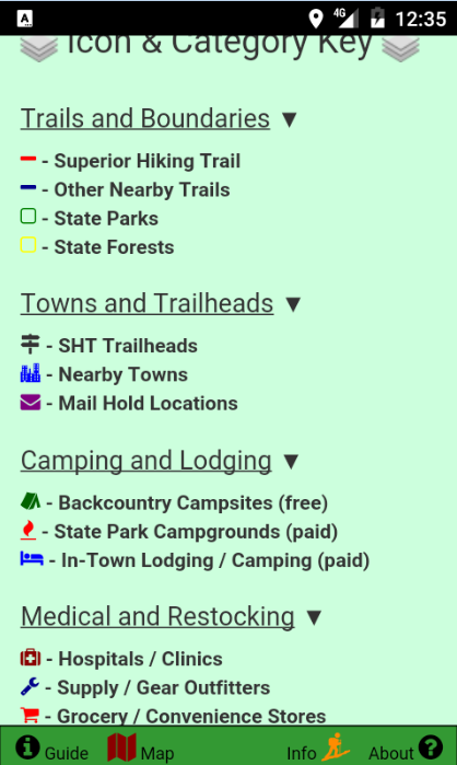
Several useful overlay layers can be toggled to allow users to create their own custom map. These layers include trail line tracks, State Park and Forest boundaries, and the locations of trailheads, campsites, lodging, grocery stores, medical services, towns, and gear outfitters.
Each of these overlay objects reveals a popup when tapped that provides more information and details about the feature. The color and icons of the features also distinguish the category that the feature belongs to and are summarized in a legend.
In addition to an informative interactive map, this map also contains a great deal of information about the Superior Hiking Trail and backpacking. This data has been compiled from many sources and formatted to be easily referenced. Some of the areas covered are general SHT and backpacking information, camping and parking regulations and details, emergency contacts, shuttle services along the trail, and information about the mail drop system.
Finally, there is a page dedicated to the many open-source projects utilized in this app. It includes the projects and resources used. On this page there is also a way to send comments or corrections for the app, in case you have addition data you would like to see included in future updates!
A great deal of time and effort has gone in to making this the best Superior Hiking Trail app available! If you enjoy the app or find it useful, give us a good rating and review!
This app will always be free, open-source, and without advertisements. Providing a comprehensive app that will help hikers be safer is more important to GeoPOI LLC than getting rich off of annoying and intrusive ads. If you enjoy this app, please consider donating and supporting more similar apps in the future!
This app requires a few special permissions in order to allow a complete user experience. These features include access to the internet to view and download map tiles, storage write and delete permissions to manage downloaded tiles, and GPS geolocation so that you can locate yourself on the map. All of these features are optional and you can choose whether or not to use them. The app will work in airplane mode.
Thanks for trying the Superior Hiking Trail Data Map, and stay tuned for more similar apps in the future! Safe and happy hiking!!
Jepretan layar


Yang Baru
- Versi: 1.0.1
- Diperbarui:
- Updated app and tile servers to provide more functional layers and latest info. Made imagery offline-only with 20MB of relevant tiles included for backcountry convenience!
Harga
- Hari ini: Gratis
- Minimal: Gratis
- Maksimum: Gratis
Pantau harga
Pengembang
- GeoPOI LLC
- Platform: Android Aplikasi (40) iOS Aplikasi (35)
- Daftar: 0 + 0
- Poin: 1 + 89 ¡
- Peringkat: 0
- Ulasan: 0
- Diskon: 1
- Video: 26
- RSS: Berlangganan
Poin
Tidak ditemukan ☹️
Peringkat
Tidak ditemukan ☹️
Daftar
Tidak ditemukan ☹️
Ulasan
Jadilah yang pertama mengulas!
Info tambahan
- Kategori:
Android Aplikasi›Peta & Navigasi - OS:
Android 4.1 dan yang lebih tinggi - Ukuran:
16 Mb - Rating Konten:
Everyone - Google Play Peringkat:
3.8(7) - Diperbarui:
- Tanggal rilis:
Kontak
- Situs Web:
 http://free.geopoi.us
Anda mungkin juga suka
-
- Trail Treker
- Android Aplikasi: Peta & Navigasi Oleh: Trail Treker
- * $1.99
- Daftar: 0 + 0 Peringkat: 0 Ulasan: 0
- Poin: 0 + 31 Versi: 3.4.4 Trail Treker is a map viewing tool for use with the Trail Treker map publishing service. Trail Treker worker works with clubs, tourism agencies and municipalities to make their maps ...
-
- Map of Iceland offline
- Android Aplikasi: Peta & Navigasi Oleh: Map Apps
- * * Gratis
- Daftar: 0 + 0 Peringkat: 0 Ulasan: 0
- Poin: 0 + 470 Versi: 2.4 Map of Iceland offline works without connecting to the Internet. No need to pay for internet in roaming. Benefits Map of Iceland offline: - Ease of Use - Highly detailed maps are ...
-
- Map It Realtour
- Android Aplikasi: Peta & Navigasi Oleh: DKP Productions LLC
- * Gratis
- Daftar: 0 + 0 Peringkat: 0 Ulasan: 0
- Poin: 0 + 8 Versi: 1.0.3 Map It Realtour / Mobile Application for Realtors With New Map It Client Version for Their Clients Map It Realtour is a new and unique Real Estate App for Agents worldwide, that was ...
-
- Memory-Map for All
- Android Aplikasi: Peta & Navigasi Oleh: Memory-Map, Inc.
- Gratis
- Daftar: 0 + 0 Peringkat: 0 Ulasan: 0
- Poin: 0 + 296 Versi: 1.3.1 Download maps for Offline GPS Navigation. No mobile data connection required. Your favorite maps and charts from OS maps, Hema, NOAA, and many more. Fully customizable map, data ...
-
- Map Over Pro - Custom Overlays
- Android Aplikasi: Peta & Navigasi Oleh: Core Software Design
- * Gratis
- Daftar: 0 + 0 Peringkat: 0 Ulasan: 0
- Poin: 0 + 103 Versi: 1.1.27 Navigate with your own maps or images overlaid on to maps from Google. Track your current location. Use waypoints to mark locations and calculate distances. Navigate to a waypoint with
-
- The Pekoe Trail
- Android Aplikasi: Peta & Navigasi Oleh: The Pekoe Trail
- Gratis
- Daftar: 0 + 0 Peringkat: 0 Ulasan: 0
- Poin: 0 + 10 Versi: 1.5.13 This is the BETA Version of The Pekoe Trail app. The app is currently in a testing phase, hence please note that certain app features may not be available for use. Explore the ...
-
- Israel Hiking Map
- Android Aplikasi: Peta & Navigasi Oleh: Israel Hiking
- * Gratis
- Daftar: 0 + 0 Peringkat: 0 Ulasan: 0
- Poin: 0 + 254 Versi: 9.20.2 Israel Hiking Map is a powerful, yet simple to use, navigation and route-planning tool for the outdoors. Geared towards hikers, bikers and off-road drivers it keeps you oriented in the
-
- Village map full HD 3d
- Android Aplikasi: Peta & Navigasi Oleh: Earth Village Map
- * Gratis
- Daftar: 0 + 0 Peringkat: 0 Ulasan: 0
- Poin: 0 + 3,677 Versi: 1.23 All Village Maps - गांव का नक्शा Village Maps will show all villages from India in a hierarchial order, or you can search any place over the world so that you can see the place details
-
- Live Earth Map-Street View Map
- Android Aplikasi: Peta & Navigasi Oleh: 8th Genration Apps -Global Earth Map Live apps
- * * Gratis
- Daftar: 0 + 0 Peringkat: 0 Ulasan: 0
- Poin: 0 + 10,113 Versi: 4.4 Live Earth Map is an advanced street view app for the person who remains busy in daily life, and can't have enough time to explore the world. Now, you can explore any location around ...
-
- Street View Map-Route Planner
- Android Aplikasi: Peta & Navigasi Oleh: Live Street View Map and Voice Navigation
- * * Gratis
- Daftar: 0 + 0 Peringkat: 0 Ulasan: 0
- Poin: 1 + 2,403 Versi: 1.5.4 Great street view features of the Street View 3D Live Camera HD improve your navigation and mapping experience when viewing streets in 3D. Seeing 360-degree panoramic views: The most ...
-
- Live Earth Map HD - Live Cam
- Android Aplikasi: Peta & Navigasi Oleh: Globally Live Satellite View Map
- * * Gratis
- Daftar: 0 + 0 Peringkat: 0 Ulasan: 0
- Poin: 0 + 48,068 Versi: 2.8.25 Explore the whole world by the live earth map HD live cam app. Visit the live satellite view in real-time. 3d earth map app is using the GPS map to display all locations. With Live ...
-
- Map Marker
- Android Aplikasi: Peta & Navigasi Oleh: theandroidseb
- * Gratis
- Daftar: 1 + 0 Peringkat: 0 Ulasan: 0
- Poin: 0 + 20,947 Versi: 3.7.0-693 This app uses Google Maps and other sources in order to allow you to place markers even without internet connection. If you have any issues with the app, please contact me by email, I ...
-
- Map of NYC Subway - MTA
- Android Aplikasi: Peta & Navigasi Oleh: Apptastic Software
- * Gratis
- Daftar: 0 + 0 Peringkat: 0 Ulasan: 0
- Poin: 0 + 760 Versi: 2.6.1 Offline line maps for New York City (MTA). It includes a complete set of offline maps for NYC public transport: subway, bus, railroad, ferry and airport. No internet connection ...
-
- Live Street View - Earth Map
- Android Aplikasi: Peta & Navigasi Oleh: Live Satellite View Earth Map - Symmetric Apps
- * Gratis
- Daftar: 0 + 0 Peringkat: 0 Ulasan: 0
- Poin: 2 + 34,265 Versi: 2.7.2 Live Street View 360 - Satellite View, Earth Map application is a combination of current Earth Map Satellite and Instant GPS 360 street images. Direct Street View 360 - Satellite View,
Anda mungkin juga suka
- Android Aplikasi
- Baru Android Aplikasi
- Peta & Navigasi Android Aplikasi : Baru
- Video Android Aplikasi
- Populer Android Aplikasi
- Peta & Navigasi Android Aplikasi : Populer
- Diskon Android Aplikasi
- Peta & Navigasi Android Aplikasi : Diskon
- Peringkat Android Aplikasi
- Ulasan Android Aplikasi
- Daftar Android Aplikasi
- Poin Android Aplikasi