| デベロッパー: | Disciple Skies Software (32) | ||
| 価格: | * * フリー | ||
| ランキング: | 0 | ||
| レビュー: | 0 レビューを書く | ||
| リスト: | 0 + 0 | ||
| ポイント: | 0 + 453 ¡ | ||
| ポイント + 1 | |||
説明
")
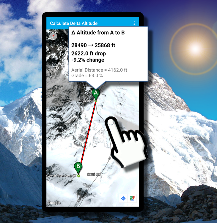
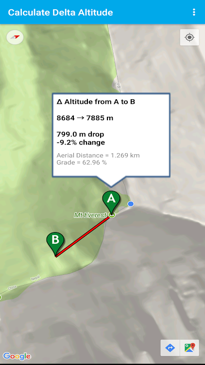
Don't guess how high you climbed: Know how high you climbed with Delta Altitude: The leading height difference calculator!
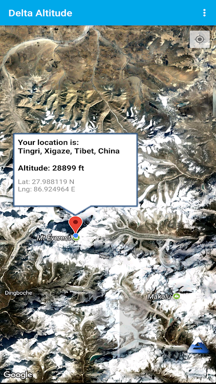
Delta Altitude is an elevation calculator that allows you to get the altitude at any point or the change in elevation between two points simply by tapping on a map.
What is the difference in height between your base camp and Mount Everest's Peak?
Tap on your base camp, then tap on Everest's peak and get your answer, instantly.
The application accesses altitude databases that are built from numerous sources of altitude data obtained using satellite and aircraft LIDAR (Laser Light Detection and Ranging) and NASA's Shuttle Radar Topography Mission.
How accurate is this app?
The horizontal resolution of the LIDAR scans is as fine as 1 meter or less while NASA's Radar scans are available at a resolution of 30 meters. So, the accuracy will vary depending on the type of scan that is available for your area or the area you select.
The most accurate values will be obtained in the United States where LIDAR scanning has been used extensively.
In general, altitude values should be accurate to 5 meters or better.
スクリーンショット


新機能
- バージョン: 2.15
- アップデート:
- Removed dead link.
Security and privacy improvements in Android 13.
デベロッパー
- Disciple Skies Software
- プラットフォーム: Android アプリ (26) Android ゲーム (6)
- リスト: 0 + 0
- ポイント: 2 + 137,423 ¡
- ランキング: 0
- レビュー: 0
- 割引: 0
- 動画: 10
- RSS: 購読する
ポイント
見つかりませんでした ☹️
ランキング
見つかりませんでした ☹️
リスト
見つかりませんでした ☹️
レビュー
最初のクチコミを書こう!
情報
- カテゴリ:
Android アプリ›ツール - オペレーティング システム:
Android 4.4 以上 - サイズ:
19 Mb - コンテンツのレーティング:
Everyone - Google Play 評価:
4.3(453) - アップデート:
- リリース日:
連絡先
- ウェブサイト:
 http://www.discipleskies.com
あなたも好きかも
-
- Delta EPA
- Android アプリ: ツール 作者: Delta Electric Power Association 1938
- フリー
- リスト: 0 + 0 ランキング: 0 レビュー: 0
- ポイント: 0 + 13 バージョン: 1.633.0039 Our Mobile App is designed to give you fast, secure account access so you can easily manage your account details, view your bill and your account balance, make payments and find ...
-
- Altitude Meter - Altimeter App
- Android アプリ: ツール 作者: ASASApps
- * * フリー
- リスト: 0 + 0 ランキング: 0 レビュー: 0
- ポイント: 0 + 3,559 バージョン: 11.1 Now its easy to check altitude measure on your smart tracking devices with the smart GPS altimeter. If you love love hiking, skiing, mountain biking or going for outdoor activities ...
-
- Altitude Measurement Online
- Android アプリ: ツール 作者: SHIGETO TAKAGI
- * フリー
- リスト: 0 + 0 ランキング: 0 レビュー: 0
- ポイント: 0 + 320 バージョン: 20230717 A simple altimeter free app that displays the altitude (meters / feet) of a point searched by keyword or specified on a map. Display latitude and longitude. Maps and satellite images ...
-
- Measure Altitude: Altimeter
- Android アプリ: ツール 作者: Apstan Apps Lab
- * フリー
- リスト: 0 + 0 ランキング: 0 レビュー: 0
- ポイント: 0 + 202 バージョン: 1.1.0 What is Altimeter? Have you any experience to check height from sea level or to measure elevation above sea level? An altimeter or an altitude meter is an instrument used to measure ...
-
- My Altitude Altimeter App
- Android アプリ: ツール 作者: Appish Studio
- * フリー
- リスト: 0 + 0 ランキング: 0 レビュー: 0
- ポイント: 0 + 646 バージョン: 1.8 Are you away from the Sea Level? Are you looking to Measure My Current Elevation and Current Altitude? Here is My Altitude Meter Free App to Calculate the Height, Altitude as well as ...
-
- My Elevation - Altitude App
- Android アプリ: ツール 作者: Apps Vista Studio
- * * フリー
- リスト: 0 + 0 ランキング: 0 レビュー: 0
- ポイント: 0 + 44 バージョン: 2.5.0 My Elevation & Altitude App is the smart and wonderful tracking app for measuring elevation and altitude. Altitude meter free app helps to measure accurate altitude and elevation with ...
-
- Altimeter GPS: Altitude Meter
- Android アプリ: ツール 作者: CloudWest Technology
- * * フリー
- リスト: 0 + 0 ランキング: 0 レビュー: 0
- ポイント: 0 + 4,499 バージョン: 1.4.2 Altimeter GPS elevation app checks altitude & current location above sea level. Altimeter gps elevation app is for measuring your altitude level. Digital Altimeter can be called ...
-
- Altimeter Pro & GPS Altitude
- Android アプリ: ツール 作者: GameBattle
- * * フリー
- リスト: 0 + 0 ランキング: 0 レビュー: 0
- ポイント: 0 + 913 バージョン: 8.1 Altimeter GPS app is an accurate Altitude meter App used to measure elevation above sea level. Elevation Altimeter map is an elevation tracker app that uses Altitude GPS online and ...
-
- Altimeter Plus & GPS Altitude
- Android アプリ: ツール 作者: PeriStudio
- * * フリー
- リスト: 0 + 0 ランキング: 0 レビュー: 0
- ポイント: 1 + 183 バージョン: 2.5 Experience azimuth compass most comprehensive and accurate altimeter application, designed to provide precise altitude measurements and essential location data with degree finder. ...
-
- Altimeter App - Find Altitude
- Android アプリ: ツール 作者: Furestic Apps
- * フリー
- リスト: 0 + 0 ランキング: 0 レビュー: 0
- ポイント: 0 + 2,188 バージョン: 1.1.0 Are you a Tourist who loves to climb mountains? Now to check the pressure levels, surface distance area above sea level by using your barometer sensor present in your phone. ...
-
- My Altitude and Elevation GPS
- Android アプリ: ツール 作者: Android Apps & Tools
- * フリー
- リスト: 0 + 0 ランキング: 0 レビュー: 0
- ポイント: 0 + 3,847 バージョン: 7.10 Our app comes with a brand new application for watch devices with Wear OS. You can easily save your current location without using your phone and synchronize data afterwards to enjoy ...
-
- Smart Altimeter - GPS Altitude
- Android アプリ: ツール 作者: Go Get International LLC
- * * フリー
- リスト: 0 + 0 ランキング: 0 レビュー: 0
- ポイント: 0 + 9,202 バージョン: 18.0 Looking for a reliable and accurate way to track your elevation during your outdoor adventures? Look no further than the Smart Altimeter! Whether you're hiking, climbing, land area, ...
-
- Altimeter & Altitude Widget
- Android アプリ: ツール 作者: Disciple Skies Software
- * * フリー
- リスト: 0 + 0 ランキング: 0 レビュー: 0
- ポイント: 0 + 20,185 バージョン: 4.62 DS Altimeter is an elevation meter, elevation logger, and altitude mapper. In addition to showing and optionally tracking your altitude, the app allows you to search the altitude for ...
-
- Star-Delta Calculator
- Android アプリ: ツール 作者: Peter Ho
- * フリー
- リスト: 0 + 0 ランキング: 0 レビュー: 0
- ポイント: 0 + 90 バージョン: 2.0.25 The star-delta calculator is used to calculate the conversion between star and delta network. Features * Convert resistor star network to delta network * Convert resistor delta network