| Concepteur: | pich (1) | ||
| Prix: | $2.64 | ||
| Classements: | 0 | ||
| Avis: | 0 Rédiger un avis | ||
| Listes: | 0 + 0 | ||
| Points: | 0 + 20 ¡ | ||
| Points + 1 | |||
Description
")
What coordinate systems does the app support?
https://www.geotrafo.com/data/App/Systemliste.htm
The conversion is done mathematically using the Helmert transformation.
In addition to the predefined parameters for the usual coordinate systems, you can also use your own parameters for the datum transformation, the projection and the ellipsoid.
Supported projections are Transversale Mercator, Lambert Conic 2SP, Stereographic and Cassini-Soldner.
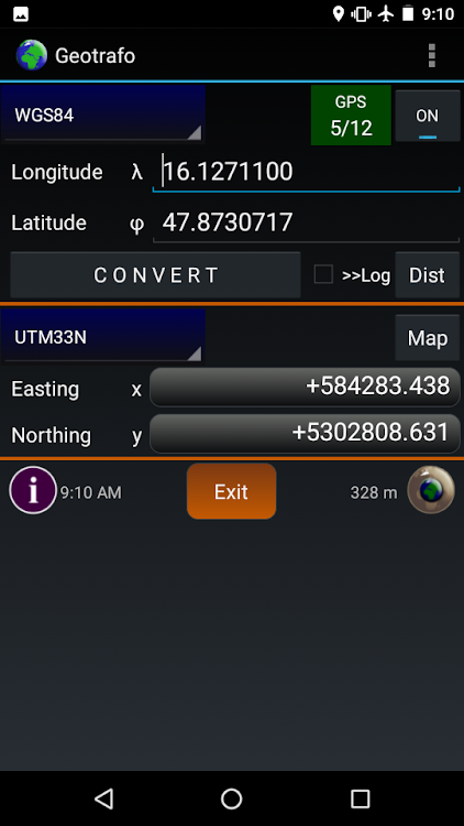
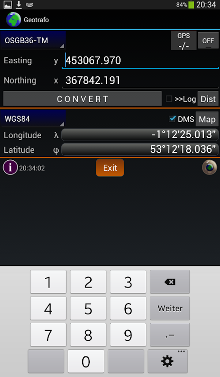
In geographic systems, the input and output can be in decimal degrees or degrees/decimal minutes or degrees/minutes/seconds.
If the checkbox is selected, then the result of the conversion is also saved in a log file, everytime, when the CONVERT button is pressed.
For this log file there are import and export functions for the data formats Text, GPX and SHP. The saved points can be copied back into the input or output fields. The Logfile LogFile.txt can also be created externally and then copied or imported into the app-specific directory. The data is managed in the Options mask.
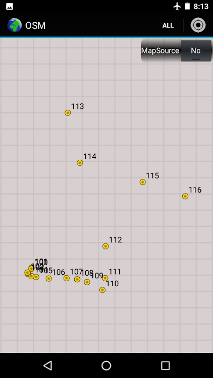
Here you can also select the map for the display of individual points. When using offline or online maps of Open Street Maps, you can also display all points of the coordinate list. With the OpenStreetMaps offline selection, the app uses ZIP files with OSMdroid data. The data can be created on the PC, for example, with the Mobac program. Alternatively, it is also possible to display the coordinates on another installed app.
The number of systems in the system selection boxes is reduced by preselecting the required countries.
With the Autoconvert function, the coordinates are converted automatically when the output system is changed or when the GPS is active when the input coordinate was updated.
The GPS can be activated on the main screen. In the satellite view, the satellite positions or data are list form is shown .
The expected accuracy and the PDOP/HDOP/VDOP values are displayed.
The compass is used to find points and calculate distances between input and output coordinates (regardless of the selected coordinate system). As an alternative to the orientation sensor, which is not always available, the GPS signal can also be used. (in the case of activ GPS always GPS compass is started). The distances are calculated in the x/y direction in different units, including the choice of any map unit KEH (= map scale). If GPS is activated, the values are constantly updated.
9 languages can be selected within the app.
(English,Deutsch,Français,Español,Čeština,Magyarul,Româneste,Hrvatski,Bosanski)
Required permissions: Location
(for using GPS)
You can find more information on the homepage
(https://www.geotrafo.com)
PDF: https://www.geotrafo.com/data/App/en/manual_app.pdf
Captures d'écran


Nouveautés
- Version: 4.5
- Mis à jour:
- What is new:
- Open Street Map Online Maps
- Sorting the coordinate list numerically
- New icon for OSM map
- Clipboard of the whole coordinate list
- New layout of warnings and messages
What is corrected:
- Display of the GPS accuracy
- Wrong filename after importing into app directory
- Errors when renaming a file or coordinate more than once
- Shape imports and exports
Prix
- Aujourd’hui: $2.64
- Minimum: $2.58
- Maximum: $2.99
Suivre l'évolution des prix
Concepteur
- pich
- Plateformes: Android Applications (1)
- Listes: 0 + 0
- Points: 0 + 20 ¡
- Classements: 0
- Avis: 0
- Remises: 0
- Vidéos: 0
- RSS: S'abonner
Points
Introuvable ☹️
Classements
Introuvable ☹️
Listes
Introuvable ☹️
Avis
Soyez le premier à donner votre avis!
Informations supplémentaires
- Catégorie:
Android Applications›Outils - Systèmes d'exploitation:
Android 7.0 ou version ultérieure - Taille:
24 Mb - Classification du contenu:
Everyone - Google Play Note:
4.2(20) - Mis à jour:
- Date de sortie:
Contacts
- Site Web:
 https://www.geotrafo.com
Découvrez également
-
- Google Play services
- Android Applications: Outils De: Google LLC
- Gratuit
- Listes: 37 + 10 Classements: 5 (1) Avis: 0
- Points: 81 + 42,873,099 Version: New Google Play services is used to update Google apps and apps from Google Play. This component provides core functionality like authentication to your Google services, synchronized ...
-
- SHAREit: Transfer, Share Files
- Android Applications: Outils De: Smart Media4U Technology Pte.Ltd.
- * * Gratuit
- Listes: 10 + 1 Classements: 4 (2) Avis: 0
- Points: 11 + 17,900,171 Version: 6.24.68_ww It s time to Share it! Share files, apps, games, videos, photos, music, recordings, documents and more with the SHAREit file transfer app. As a super-fast and safe app to transfer big ...
-
- MyTelkomsel - Buy Package
- Android Applications: Outils De: Telkomsel
- * Gratuit
- Listes: 3 + 0 Classements: 0 Avis: 0
- Points: 0 + 10,505,731 Version: 7.5.0 MYTELKOMSEL: ONE-STOP SOLUTION FOR ALL Can you believe it? We ve outdone ourselves to bring you the best digital and telecommunication solutions. With a fresh and modern look, ...
-
- myIM3: Data Plan & Buy Package
- Android Applications: Outils De: Indosat Ooredoo Hutchison
- * Gratuit
- Listes: 0 + 0 Classements: 0 Avis: 0
- Points: 3 + 9,162,442 Version: 82.1.0 Unlock a world of convenience right at your fingertips with myIM3 app. More excitement to explore, now accessible for everyone! Stay Entertained with a Variety of Fun Content Beyond ...
-
- Turbo VPN - Secure VPN Proxy
- Android Applications: Outils De: Innovative Connecting
- * * Gratuit
- Listes: 3 + 1 Classements: 0 Avis: 0
- Points: 3 + 8,391,428 Version: 4.0.7 Turbo VPN is a free and unlimited VPN proxy, offering you a fast VPN connection and stable VPN servers. Turbo VPN help you secure your online activities and enjoy the web and app ...
-
- AVG AntiVirus & Security
- Android Applications: Outils De: AVG Mobile
- * * Gratuit
- Listes: 6 + 2 Classements: 5 (1) Avis: 0
- Points: 2 + 7,837,581 Version: 24.7.0 Get AVG AntiVirus FREE - Mobile Security for Android to help protect you from harmful viruses and malware. Keep your personal data safe with App Lock, Photo Vault, Wi-Fi Security Scan,
-
- Avast Antivirus & Security
- Android Applications: Outils De: Avast Software
- * * Gratuit
- Listes: 5 + 2 Classements: 5 (1) Avis: 0
- Points: 2 + 7,223,054 Version: 24.7.0 Protect against viruses & other types of malware with Avast Mobile Security, our free antivirus app for Android. Trusted by over 435 million people. Protect your privacy by receiving ...
-
- gov.br
- Android Applications: Outils De: Serviços e Informações do Brasil
- Gratuit
- Listes: 1 + 0 Classements: 0 Avis: 0
- Points: 0 + 7,113,210 Version: 3.6.2 Agora sim! Estamos de cara nova! E com novidades! O app "gov.br" (antes Meu gov.br) está renovado para que você tenha uma experiência mais simplificada: - Para começar, você pode ...
Découvrez également
- Android Applications
- Nouveautés Android Applications
- Outils Android Applications : Nouveautés
- Vidéos Android Applications
- Populaires Android Applications
- Outils Android Applications : Populaires
- Remises Android Applications
- Outils Android Applications : Remises
- Classements Android Applications
- Avis Android Applications
- Listes Android Applications
- Points Android Applications