| مطوّر البرامج: | Ilya Bogdanovich (1) | ||
| السعر: | * مجاني | ||
| لتصنيفات: | 0 | ||
| المراجعات: | 0 أكتب مراجعة | ||
| قوائم: | 0 + 0 | ||
| النقاط: | 0 + 88,712 ¡ | ||
| النقاط + 1 | |||
الوصف
")
Record GPS tracks of your trips, analyze statistics, and share them with your friends!
Geo Tracker can help:
• Making the way back in an unfamiliar area without getting lost;
• Sharing your route with friends;
• Using someone else's route from GPX, KML or KMZ file;
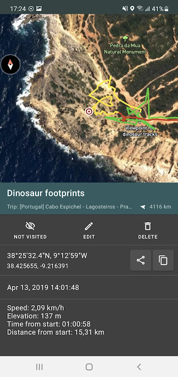
• Marking important or interesting points on your way;
• Locating a point on the map, if you know its coordinates;
• Showing off colorful screenshots of your accomplishments on social networks.
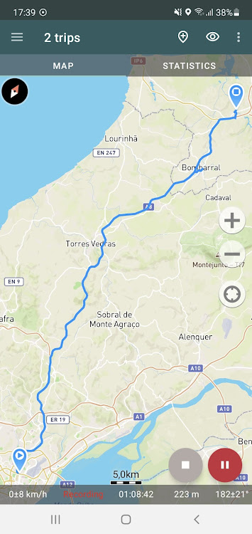
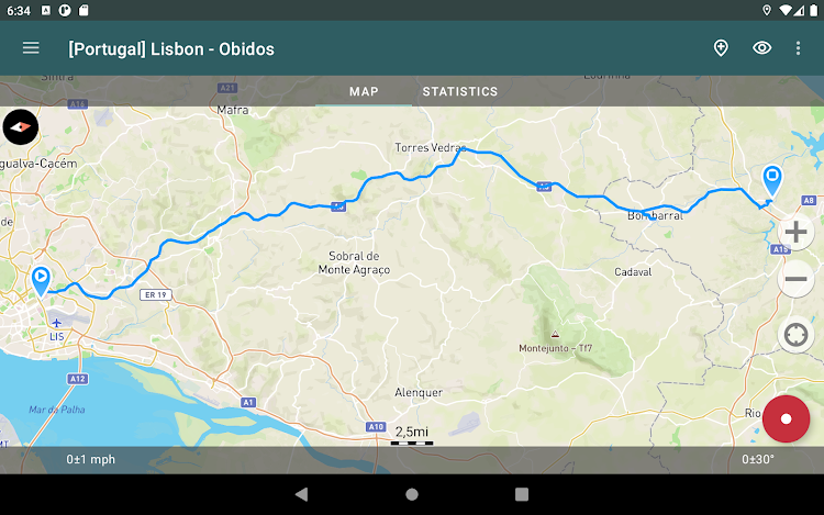
You can view the tracks and the surrounding area in the application using a scheme from OSM or Google, as well as satellite images from Google or Mapbox - this way you will always have the most detailed map of the area anywhere worldwide. The map areas you view are saved to your phone and remain available offline for a while (this works best for OSM maps and Mapbox's satellite images). To record and calculate track statistics only a GPS signal is needed - the Internet is only required to download map images.
While driving, you can turn on the navigation mode, in which the map automatically rotates in the direction of travel, which greatly simplifies navigation.
The application can record tracks while being in the background (on many devices, this requires additional configuration in the system - be careful! The instructions for these settings are available in the application). Power consumption in background mode is greatly optimized - on average, the phone's charge is enough for a whole day of recording. There's also an economy mode - you can turn it on in the app settings.
Geo Tracker calculates the following statistics:
• Distance traveled and recording time;
• Max and average speed on the track;
• Time and average speed in motion;
• Min and max altitude on the track, altitude difference;
• Vertical distance, ascent and speed;
• Min, max, and average slope.
Also, there are detailed charts of speed and elevation data available.
Recorded tracks can be stored as GPX, KML, and KMZ files, so they can be used in other well-known applications like Google Earth or Ozi Explorer. Tracks are stored locally on your device and are not transferred to any servers.
The app does not make money from ads or your personal data. To support the development of the project, a voluntary donation can be made in the application.
Useful tips & tricks to solve common GPS issues with your smartphone:
• If you start the tracking please wait a bit until the GPS signal is found.
• Restart your smartphone and make sure that you have a "clear view" of the sky before you start (no disturbing objects like high buildings, forests, etc.).
• The reception conditions are permanently changing because they are influenced by the following factors: weather, season, positioning of satellites, areas with bad GPS coverage, high buildings, forests, etc.).
• Go to phone settings, choose "Location" and activate it.
• Go to phone settings, choose "Date & time" and activate the following options: "Automatic date & time" and "Automatic time zone". It may occur that it takes longer until the GPS signal is found if your smartphone is set to the wrong time zone.
• Deactivate the airplane mode in your phone settings.
If none of these tips & tricks helped to solve your issues, deinstall the app and reinstall it again.
Be aware that Google uses in their Google Maps app not only the GPS data but also additional data of the current location from surrounding WLAN networks and/or mobile networks.
More answers to frequent questions and solutions for popular issues can be found on the website: https://geo-tracker.org/faq/?lang=en
لقطات


الميزات الجديدة
- الإصدار: 5.3.3.3845
- تم التحديث:
- - The upper panel has been optimized. Now, it takes up less space;
- Added function to empty the trash bin. Now, tracks in the trash bin will be automatically deleted after 30 days;
- A display of the track recording date has been added to the statistics screen. You can see it under the track name, including in the screenshots;
- More data was added to the trip list: overall trip count and number of selected and trashed trips;
السعر
-
*عمليات الشراء داخل التطبيق - اليوم: مجاني
- الحد الأدنى: مجاني
- الحد الأقصى: مجاني
تتبّع الأسعار
مطوّر البرامج
- Ilya Bogdanovich
- المنصات: Android تطبيقات (1)
- قوائم: 0 + 0
- النقاط: 0 + 88,712 ¡
- لتصنيفات: 0
- المراجعات: 0
- تخفيضات: 0
- أشرطة فيديو: 0
- RSS: اشتراك
النقاط
غير معثور عليه ☹️
لتصنيفات
غير معثور عليه ☹️
قوائم
غير معثور عليه ☹️
المراجعات
كن الأول لمراجعة هذا المنتج!
معلومات إضافية
- الفئة:
Android تطبيقات›السفر ومعلومات محلية - نظام التشغيل:
Android 5.0 والأحدث - الحجم:
21 Mb - تقييم المحتوى:
Everyone - Google Play تقييم:
4.6(88,712) - تم التحديث:
- تاريخ الإصدار:
جهات الاتصال
- الموقع الإلكتروني:
 https://geo-tracker.org/
قد يعجبك ايضا
-
- GPS Camera Map Geotag Location
- Android تطبيقات: السفر ومعلومات محلية بواسطة: Tools Village - GPS_Map_Camera, GPS_Speedometer
- * * مجاني
- قوائم: 0 + 0 لتصنيفات: 0 المراجعات: 0
- النقاط: 0 + 3,001 الإصدار: 1.88 Auto GPS Map Camera is here to Add Geotag Location on Photos. Track your current GPS Location, save it and even share. It has become easy with this gps camera location Application & ...
-
- GPS Navigation: Live Earth Map
- Android تطبيقات: السفر ومعلومات محلية بواسطة: Tap Apps Studio
- * مجاني
- قوائم: 0 + 0 لتصنيفات: 0 المراجعات: 0
- النقاط: 0 + 7,187 الإصدار: 1.7.9 GPS Navigation Live Street Map and Driving Direction allow you to make driving route on world map. With GPS navigation app & street view maps helps you to visit any famous place of ...
-
- GPS Maps Navigation:Directions
- Android تطبيقات: السفر ومعلومات محلية بواسطة: Dream Edge Technologies
- * * مجاني
- قوائم: 0 + 0 لتصنيفات: 0 المراجعات: 0
- النقاط: 1 + 5,283 الإصدار: 1.8.7 GPS Navigation Provides users with real-time navigation and directions to help them reach their desired destination. GPS Navigation app is a useful tool to find the routes and ...
-
- GPS Navigation Live Map Road
- Android تطبيقات: السفر ومعلومات محلية بواسطة: Map Zone Studio
- * * مجاني
- قوائم: 0 + 0 لتصنيفات: 0 المراجعات: 0
- النقاط: 0 + 28,948 الإصدار: 4.1.6 Discover seamless exploration with the ultimate GPS Navigation & Map Direction App. This lightweight free navigation app helps you find the shortest route to your destination, avoid ...
-
- GPS Maps & Navigations
- Android تطبيقات: السفر ومعلومات محلية بواسطة: SoftCodes
- * مجاني
- قوائم: 0 + 0 لتصنيفات: 0 المراجعات: 0
- النقاط: 0 + 3,300 الإصدار: 4.03 With search, save, send feature the fastest GPS Location and Navigation Map. - for the best results use the app outdoors - IMPORTANT: The application does not reach or collect any of ...
-
- GPS Live Satellite View Map
- Android تطبيقات: السفر ومعلومات محلية بواسطة: Game Axe
- * * مجاني
- قوائم: 0 + 0 لتصنيفات: 0 المراجعات: 0
- النقاط: 0 + 7,253 الإصدار: 5.1.0 GPS Live Satellite View Map is a state-of-the-art navigation app that offers a seamless and intuitive experience for users who are looking for a reliable, accurate, and up-to-date ...
-
- GPS Navigator CityGuide
- Android تطبيقات: السفر ومعلومات محلية بواسطة: GEOPHONE GROUP INTERNATIONAL Oy
- * مجاني
- قوائم: 0 + 0 لتصنيفات: 0 المراجعات: 0
- النقاط: 0 + 36,733 الإصدار: 12.0.259 GPS Navigator with HERE, OSM and other maps CityGuide the new-generation offline GPS navigator, which enables you to select and use maps from various map vendors.: OSM (OpenStreetMap),
-
- GPS Navigation + Compass
- Android تطبيقات: السفر ومعلومات محلية بواسطة: aminlogic
- * مجاني
- قوائم: 0 + 0 لتصنيفات: 0 المراجعات: 0
- النقاط: 0 + 5,291 الإصدار: 52.0.6 GPS Navigation + Compass is an application that allows you to navigate your destinations and track your locations according to directions on Google maps. This app is combination of ...
-
- GPS Offline Maps & Navigation
- Android تطبيقات: السفر ومعلومات محلية بواسطة: RCSTUDIOAPPS
- * * مجاني
- قوائم: 0 + 0 لتصنيفات: 0 المراجعات: 0
- النقاط: 0 + 14,118 الإصدار: 1.59 Offline Maps and Directions main features: Offline Maps: Download Offline Maps & save mobile data, and no internet is required. Easy Maps & Navigation: Trusted by many travelers for ...
-
- GPS Camera Lite For Location
- Android تطبيقات: السفر ومعلومات محلية بواسطة: All Excellent Apps
- * * مجاني
- قوائم: 0 + 0 لتصنيفات: 0 المراجعات: 0
- النقاط: 0 + 2,912 الإصدار: 1.5.6 A photo having GPS coordinates printed on it has become easy now with the help of GPS lite Tool. From Address, Latitude, Longitude to Altitude And Date Time, You can have every ...
-
- GPS Logger
- Android تطبيقات: السفر ومعلومات محلية بواسطة: BasicAirData
- مجاني
- قوائم: 0 + 0 لتصنيفات: 0 المراجعات: 0
- النقاط: 0 + 2,344 الإصدار: New BasicAirData GPS Logger is a simple App for recording your position and your path. It's a basic and lightweight GPS tracker focused on accuracy, with an eye to power saving. It works ...
-
- GPS Earth Maps Live Navigation
- Android تطبيقات: السفر ومعلومات محلية بواسطة: Cloud Park
- * مجاني
- قوائم: 0 + 0 لتصنيفات: 0 المراجعات: 0
- النقاط: 0 + 8,609 الإصدار: 3.2.7 Experience efficient route planning and navigation with our GPS Satellite Earth Maps & GPS Navigation app, offering the shortest routes along with real-time traffic alerts. The ...
-
- GPS Status PRO - (legacy key)
- Android تطبيقات: السفر ومعلومات محلية بواسطة: MobiWIA Kft.
- $13.99
- قوائم: 1 + 0 لتصنيفات: 0 المراجعات: 0
- النقاط: 0 + 10,054 الإصدار: 11.0.12 NOTE: The main (free) app now supports in-app payments to purchase a PRO license. Please purchase a license from the side navigation menu of GPS Status & Toolbox. To encourage the ...
-
- GPS Essentials
- Android تطبيقات: السفر ومعلومات محلية بواسطة: mictale.com
- * * مجاني
- قوائم: 0 + 0 لتصنيفات: 0 المراجعات: 0
- النقاط: 0 + 45,737 الإصدار: New The most complete GPS tool available: Navigate, manage waypoints, tracks, routes, build your own dashboard from 45 widgets. Dashboard Shows navigation values such as: Accuracy, ...
قد يعجبك ايضا
- Android تطبيقات
- جديد Android تطبيقات
- السفر ومعلومات محلية Android تطبيقات : جديد
- أشرطة فيديو Android تطبيقات
- أعلى Android تطبيقات
- السفر ومعلومات محلية Android تطبيقات : أعلى
- تخفيضات Android تطبيقات
- السفر ومعلومات محلية Android تطبيقات : تخفيضات
- لتصنيفات Android تطبيقات
- المراجعات Android تطبيقات
- قوائم Android تطبيقات
- النقاط Android تطبيقات