| 開發人員: | Vlahi Systems LLC (2) | ||
| 價錢: | 免費 | ||
| 排名: | 0 | ||
| 評測: | 0 寫評論 | ||
| 清單: | 0 + 0 | ||
| 點數: | 0 + 7 (4.6) ¡ | ||
| App Store | |||
描述
")
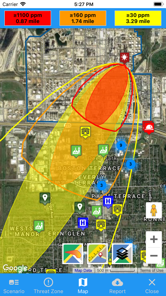
Our software can be used anywhere, anyplace, on any device, phone, tablet or PC. You get free access to ALOHA® model which is the hazard modeling program for the CAMEO® software suite, widely used to plan for and respond to chemical emergencies.
What to expect?
A modern no-cost chemical event modelling application, integrated with google maps, location search services, street view, traffic, real time current location, distance measurement, impacted places, contours and zones.
Subscription modules which enable enhanced capabilities:
Internet live weather
Sensor Driven Plume and Release Location Identification
CERES integrates gas sensors and local meteorological data to plot an accurate gas plume based on the real-world conditions
Location Tracking for Personal Devices (phones, tablets, G7s and others)
Chemical Mixtures
Google Places
Local live meteorological station integrated through our Data Acquisition Application
Advanced reporting including map images, impacted contours, zones and impacted places
Infiltration analysis for multiple impacted places
Model additional chemicals (Gasoline, LPG, Diesel, Formaldehyde, Sarin(GB) ...), and prioritize "My Chemicals"
Share incident data by incident link
Quick access to 5 minute footprint intervals
Predefined scenarios
Sharing and Collaboration
KML import / export
Planning, sharing and collaboration
Import your high resolution aerial imagery
Meteorological and Sensors Hardware: Tempest WeatherFlow, Honeywell Area RAE, AirMar NMEA 200,WeatherPack, ALOHA SAM, MODBUS RTU/TCP
ERG Guide Integration
Enterprise support - multiple sites and multiple users per site managed under the same account
New ! - Monitoring Package
Explosive materials (TNT blast equivalence for the most common explosive substances)
IBM Weather enhanced current conditions (4km x 4km resolution weather data for any point in the world)
Live Facility Monitoring (meteorological conditions and mobile and fixed sensors)
Visual and Audible Alarms (met and sensors)
Quick Response for immediate identification of receptors downwind from the event (using live downwind cone)
Upwind cone to help identify likely / possible emission sources to assist with odor complaint investigation, regulatory compliance and claims management
Optimizing Mobile Gas Sensors Deployment
Time interval reporting and meteorological wind rose
Historical data archiving, analysis and reports
Wide Area Package
Remove the 50 miles diameter limitation
Model your predefined scenarios in transit anywhere
Continuous development and support
We wish you a pleasant experience and welcome your feedback and questions at ceres@vlahi.com.
螢幕擷取畫面


價錢
- 今天: 免費
- 最小值: 免費
- 最大值: 免費
追蹤票價
開發人員
- Vlahi Systems LLC
- 平台: Android 應用程式 (1) iOS 應用程式 (1)
- 清單: 0 + 0
- 點數: 0 + 45 ¡
- 排名: 0
- 評測: 0
- 折扣: 0
- 影片: 0
- RSS: 訂閱
點數
0 ☹️
排名
0 ☹️
清單
0 ☹️
評測
成為第一個評論 🌟
其他資訊
聯絡人
- 個人網站:
 https://www.vlahi.com
- 🌟 分享
- App Store
你可能還喜歡
-
- Ceres Global
- iOS 應用程式: 商業 由: Ceres Global Ag Corp.
- 免費
- 清單: 0 + 0 排名: 0 評測: 0
- 點數: 0 + 0 版本: 4.0.744 Real-time harvest information for growers, by Ceres Global. The Ceres Global app is an essential mobile solution that connects your operation to your grain facility, providing ... ⥯
-
- Ceres Imaging
- iOS 應用程式: 商業 由: Ceres Imaging, Inc
- 免費
- 清單: 0 + 0 排名: 0 評測: 0
- 點數: 0 + 13 (4.6) 版本: 24.3.0 Ceres Imaging provides precise, accurate aerial imagery for agriculture. We believe the future of farming depends on providing growers with the right tools to cover more ground, make ... ⥯