| Nhà phát triển: | Bay Ridge Civic Association (2) | ||
| Giá bán: | Miễn phí | ||
| Xếp hạng: | 0 | ||
| Đánh giá: | 0 Viết đánh giá | ||
| Danh sách: | 0 + 0 | ||
| Điểm: | 0 + 2 (5.0) ¡ | ||
| App Store | |||
Mô tả
")
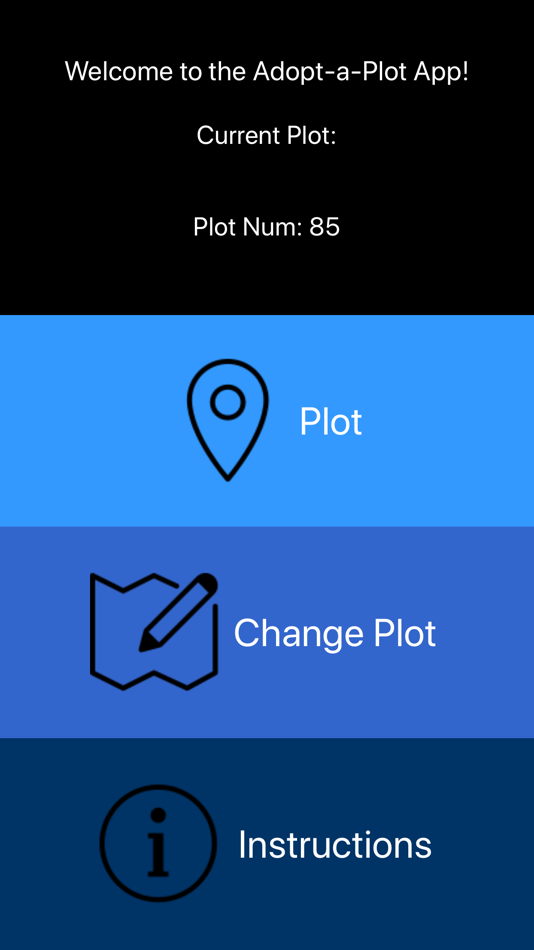
The Adopt-a-Plot app uses the phone’s GPS to continually triangulate and display the user’s position. At the same time, the boundaries of the selected polygon are accurately displayed as a map overlay. The accuracy of the user’s location, in relation to plot boundaries, is limited only to the inherent accuracy of the phone’s GPS (typically about 15-30 feet). If needed, accuracy can be improved by pairing with an external GPS.
Users can simply scroll through a list of pre-loaded plots or create their own plot by inputting exact latitude and longitude coordinates. The app draws a red box around the desired area and displays the location of the user as a pulsing blue dot.
Included Features:
· Real-time positioning
· Drop down menu of currently programmed plots
· A coordinate input function
· Icons to zoom in and out of the map
· Accurate red border around the desired plot as map overlay
· Icons to switch the view between the user and the selected plot, and
· An instructions menu, specific to Bay Ridge, Maryland, that describes how to cut the invasive species in forests along with safety precautions of going into the forest.
This app can drain phone batteries, so it is suggested to bring a portable charger or turn off the phone when not in use.
This app was developed in 2019, as a “Community Challenge Project” for the benefit of the Bay Ridge Civic Association, by a group of South River High School junior year STEM students: Ari Wasch, Samara Hatley, and Nick Merton. In particular, Ari wrote the code using Xcode for the Apple app and Android Studio for the Android app.
Ảnh chụp màn hình


Giá bán
- Hôm nay: Miễn phí
- Tối thiểu: Miễn phí
- Tối đa: Miễn phí
Theo dõi giá
Nhà phát triển
- Bay Ridge Civic Association
- Nền tảng: iOS Ứng dụng (2)
- Danh sách: 0 + 0
- Điểm: 0 + 7 ¡
- Xếp hạng: 0
- Đánh giá: 0
- Giảm giá: 0
- Video: 0
- RSS: Đăng ký
Điểm
0 ☹️
Xếp hạng
0 ☹️
Danh sách
0 ☹️
Đánh giá
Hãy là người đầu tiên đánh giá 🌟
Thông tin bổ sung
- Phiên bản: 1.1.1
- ID: Bay-Ridge-Civic-Association.Adopt-A-Plot
- Danh mục:
iOS Ứng dụng›Bản đồ và dẫn đường - HĐH:
iPad,iPhone,iOS 12.1 trở lên - Kích thước:
8 Mb - Ngôn ngữ được hỗ trợ:
English - Xếp hạng nội dung:
4+ - App Store Xêp hạng:
5.0(2) - Cập nhật:
- Ngày phát hành:
Bạn cũng có thể thích
-
- iNavX: Marine Navigation
- iOS Ứng dụng: Bản đồ và dẫn đường Bởi: NavX Studios LLC
- Miễn phí
- Danh sách: 0 + 0 Xếp hạng: 0 Đánh giá: 0
- Điểm: 7 + 20,654 (4.8) Phiên bản: 5.8.1 Marine navigation is made easy with iNavX - the world's #1 handheld Chartplotter. Access marine charts, maps, weather, AIS and more! iNavX is the only app to give you complete ... ⥯
-
- i-Boating: Marine Charts & Gps
- iOS Ứng dụng: Bản đồ và dẫn đường Bởi: Bist LLC
- Miễn phí
- Danh sách: 0 + 1 Xếp hạng: 0 Đánh giá: 0
- Điểm: 1 + 13,648 (4.5) Phiên bản: 162.0.0 This App offers access to Marine Charts for USA,Canada,UK/Ireland,Germany,Netherlands/Holland & Europe Rivers (Danube,Drava,Rhein etc). Coverage includes NOAA marine vector ... ⥯
-
- Savvy Navvy Boating Navigation
- iOS Ứng dụng: Bản đồ và dẫn đường Bởi: savvy navvy
- * Miễn phí
- Danh sách: 0 + 1 Xếp hạng: 0 Đánh giá: 0
- Điểm: 2 + 5,453 (4.7) Phiên bản: 2.2.18660 Savvy Navvy: Your All-in-One Marine Navigation App Savvy Navvy is the ultimate marine navigation tool that simplifies charts, weather forecasts, tides, GPS tracking, and route planning ⥯
-
- Argo - Boating Navigation
- iOS Ứng dụng: Bản đồ và dẫn đường Bởi: Argo Navigation, LLC
- * Miễn phí
- Danh sách: 0 + 1 Xếp hạng: 0 Đánh giá: 0
- Điểm: 0 + 5,915 (4.9) Phiên bản: 2.13.2 Argo™ is an easy-to-use navigation and social boating app FREE to download and FREE to use! Find and route to new destinations anywhere in North America, track your boat trips, see ... ⥯
-
- ImmoScout24 - Real Estate
- iOS Ứng dụng: Bản đồ và dẫn đường Bởi: ImmobilienScout GmbH
- Miễn phí
- Danh sách: 0 + 0 Xếp hạng: 0 Đánh giá: 0
- Điểm: 1 + 4,904 (4.6) Phiên bản: 27.5 ImmoScout24 is Germany's No. 1 real estate portal. Are you looking for an apartment? Do you want to rent, let, buy or sell a property? Private or commercial? Then you've come to the ... ⥯
-
- RBC Land VN
- iOS Ứng dụng: Bản đồ và dẫn đường Bởi: TRAN TRUNG CHUYEN
- $49.99
- Danh sách: 0 + 0 Xếp hạng: 0 Đánh giá: 0
- Điểm: 5 + 1 (5.0) Phiên bản: 1.0.1 RBC Land VN is a dedicated tool for managing and supporting real estate asset appraisal, including details on land use boundaries. Users can quickly access the boundary coordinate ... ⥯
-
- Deed Calls - Grid - Stakeout
- iOS Ứng dụng: Bản đồ và dẫn đường Bởi: CORVALLIS MICROTECHNOLOGY, INC.
- $34.99
- Danh sách: 0 + 0 Xếp hạng: 0 Đánh giá: 0
- Điểm: 0 + 0 Phiên bản: 1.0.7 Deed Calls - Grid - Stakeout for iPAD, iPhone and iPod touch provides the functions for creating an area by entering deed calls, generating grid points over the area, as well as ... ⥯
-
- Scott IPC
- iOS Ứng dụng: Bản đồ và dẫn đường Bởi: Scott IPC
- Miễn phí
- Danh sách: 0 + 0 Xếp hạng: 0 Đánh giá: 0
- Điểm: 0 + 17 (5.0) Phiên bản: 4.1.3 Scott International Procedures, LLC offers comprehensive International Procedures training and equips business aviation and military pilots with a wide range of resources and tools for ⥯
-
- StarPilot
- iOS Ứng dụng: Bản đồ và dẫn đường Bởi: Starpath Corp
- $49.99
- Danh sách: 0 + 0 Xếp hạng: 0 Đánh giá: 0
- Điểm: 0 + 7 (4.9) Phiên bản: 3.0.7 The state-of-the-art solution to navigation computations on your iPhone or iPod touch. StarPilot does celestial sight reductions of all bodies using high-precision internal almanac, ... ⥯
-
- Drive around the World
- iOS Ứng dụng: Bản đồ và dẫn đường Bởi: BecomingSystems
- Miễn phí
- Danh sách: 0 + 0 Xếp hạng: 0 Đánh giá: 0
- Điểm: 0 + 3 (1.0) Phiên bản: 2.10.5 You can have fun to drive virtually by continually loading panorama view and define the driving/walking route which is drawn by hand. Please enjoy a virtual driving by the serial ... ⥯
-
- Plains Locator
- iOS Ứng dụng: Bản đồ và dẫn đường Bởi: Flipwire
- * Miễn phí
- Danh sách: 0 + 0 Xếp hạng: 0 Đánh giá: 0
- Điểm: 0 + 1 (5.0) Phiên bản: 1.4.1 Plains Locator: Convert and Map Public Land Survey System (PLSS) Land Descriptions to Latitude and Longitude coordinates. Results include GPS Coordinates and distance to the centre of ... ⥯
-
- AwtlTrack
- iOS Ứng dụng: Bản đồ và dẫn đường Bởi: Advance Wireless Technology Co. LTD
- Miễn phí
- Danh sách: 0 + 0 Xếp hạng: 0 Đánh giá: 0
- Điểm: 0 + 1 (5.0) Phiên bản: 1.6.13 Tracking Mobile App helps your prestigious clients to keep their assets Safe & Secure. It lets you track your vehicle(s) on the go, with detailed information. - Dashboard for Admin ... ⥯
-
- EZ Celestial Navigation
- iOS Ứng dụng: Bản đồ và dẫn đường Bởi: EZ Celestial LLC
- $29.99
- Danh sách: 0 + 0 Xếp hạng: 0 Đánh giá: 0
- Điểm: 0 + 19 (4.9) Phiên bản: 1.3 Celestial navigation has never been easier! With ezAlmanacOne and a sextant you will be finding your fix like a pro in no time! ezAlmanacOne is an evolution of the iPad version of ... ⥯
-
- Maneuvering Board
- iOS Ứng dụng: Bản đồ và dẫn đường Bởi: Universal Queue LLC
- $4.99
- Danh sách: 0 + 0 Xếp hạng: 0 Đánh giá: 0
- Điểm: 0 + 8 (5.0) Phiên bản: 2.1 Are you still relying on old-school paper maneuvering boards? Yearning for a more innovative approach to maritime navigation? Your wait is over. Our state-of-the-art electronic ... ⥯