| 開發人員: | Xample Sarl (1) | ||
| 價錢: | 免費 | ||
| 排名: | 0 | ||
| 評測: | 0 寫評論 | ||
| 清單: | 0 + 1 | ||
| 點數: | 3 + 607 (4.6) ¡ | ||
| App Store | |||
描述
")
- Everything you need to fly around the world
- Plan your flight in a few minutes
- Fly relaxed with up-to-date information
Air Navigation Pro is a high-quality flight assistant app for pilots worldwide. Benefit from the following main features:
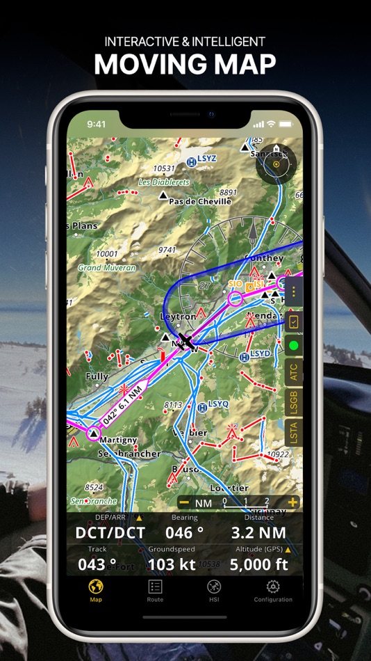
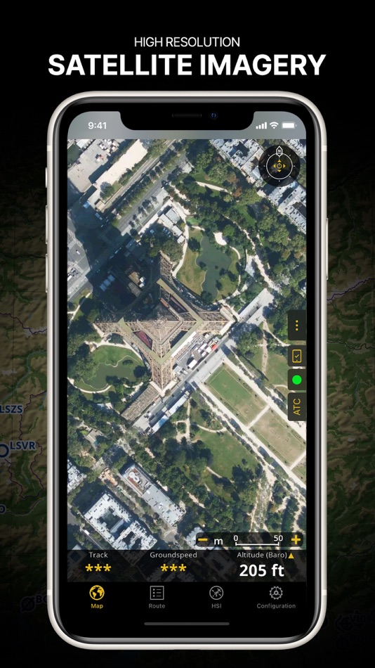
MOVING MAP
Plan and navigate using our interactive moving map. Choose between aeronautical charts, satellite or our vector map as a background. On top of that, the moving map displays waypoints, NOTAM, obstacles and airspaces from our comprehensive, always up-to-date worldwide aeronautical database. Tap on any waypoint directly on the map to easily create a route. Personalize the values shown on the navbar to have exactly the information you need: altitude, vertical speed, bearing, distance to the next waypoint, ETA calculations, etc. Choose the airport departure and arrival procedures for your route to have them also displayed on top of the moving map.
ENHANCED TRAFFIC AWARENESS
Get visual and audio alerts in all languages for nearby conflicting traffic. Choose your preferred traffic icon between generic, aircraft or TCAS symbols. Your safety is important to us, which is why we partnered with SafeSky to ensure our users have live traffic data during their flight. Benefit from the native integration with SafeSky included in our new Smart Lite, Smart Classic and Smart Advanced subscriptions—a two-in-one package!
ADVANCED WEATHER LAYERS
In addition to the basic weather reports & forecast of winds, TAF and METAR for your flight, subscribers of the Smart Advanced plan can activate see-through weather layers on top of the moving map. Available layers include rain radar, wind, pressure, clouds and rain, visibility, gust and for Germany, Switzerland, Austria and the Balkans, we also have GAFOR. Tap on any point on the map to see the weather information for that area. Review the weather forecast for up to three days ahead.
NOTAM
After creating your route, set the departure time in the future to have the moving map display the NOTAM active for that specific time. NOTAM on the map change color dynamically based on their status.
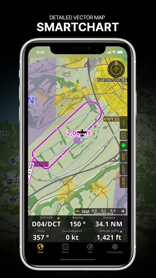
SMARTCHART
Our cutting-edge SmartChart is a highly detailed and intelligent vector-based map that adapts to your needs, providing you with adequate information at any zoom level. The SmartChart optimizes the display of shadows to easily distinguish between valleys and mountains, and the text remains perfectly aligned, guaranteeing optimal readability. Including the latest significant improvements with forests and detailed airport information.
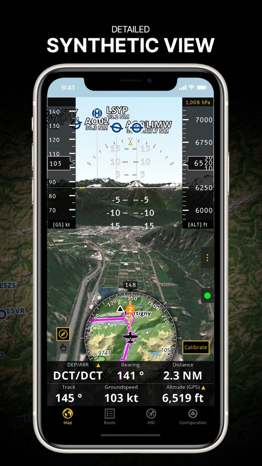
ELEVATION PROFILE & SYNTHETIC VIEW
Enable the profile view below the navbar for enhanced situational awareness of the elevation ahead of you or along your route. Choose the corridor width between 0 to 5 NM and overlay options: airspaces, NOTAM, obstacles, wind components, populated places, etc. Switch to the synthetic view for additional terrain information, plus an artificial horizon with altitude and vertical speed indicators. This function can also be used to pan around while preparing for your flight. Activate TAWS on the moving map as well as on the synthetic view.
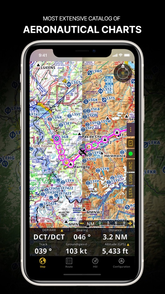
AERONAUTICAL CHARTS & APPROACH CHARTS
We offer the most extensive worldwide catalog of aeronautical charts, including the ICAO charts. Have the georeferenced approach charts displayed on top of the moving map or the 3D view.
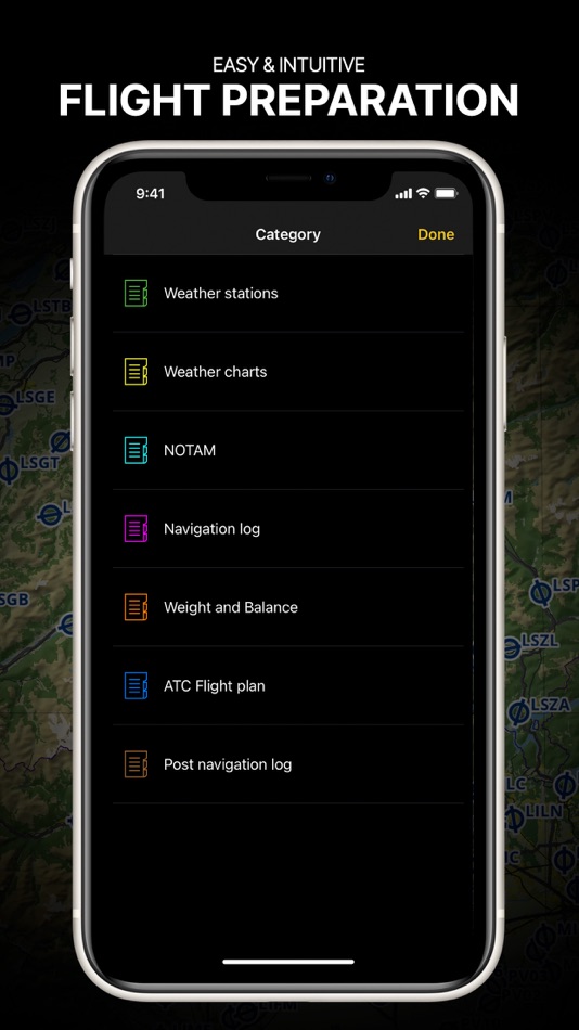
BRIEFING
Prepare your flight with our briefing section by creating documents with NOTAM and weather charts & stations relevant to your planned route. Optimize time by creating an aircraft profile which will be used in the Briefing section to pre-fill for you the ATC Flight Plan and calculate the W&B.
AND SO MUCH MORE!
Please note that WiFi-only devices do not include an internal GPS receptor, an external sensor is required. Refer to our user manual on our website: www.airnavigation.aero
Terms of use: https://www.airnavigation.aero/en/terms-of-use.html
螢幕擷取畫面


新功能
- 版本: 8.4.009
- 發佈日期:
- Welcome to version 8.4—A Major Upgrade!
- New Flight Briefing: Link documents to flights, store passenger & crew info, auto-generate essential documents and export everything as a single PDF.
- Graphical Weight & Balance: Intuitive W&B editor with aircraft data downloaded from our database. Currently available for select aircraft—more to come!
- AI-Powered Auto VFR Route Planner: Instantly find the most efficient VFR route based on weather, airspace and terrain at departure time.
- Improved Waypoint Popover: Get more detailed waypoint information in an easy-to-read format.
- New Document Browser: Filter charts by type for quick access.
- GAFOR for Bulgaria: Expanded weather coverage with the latest GAFOR forecasts for Bulgaria.
- Title of Transport for Switzerland: Generate the required document directly from the app.
價錢
- 今天: 免費
- 最小值: 免費
- 最大值: 免費
追蹤票價
開發人員
- Xample Sarl
- 平台: iOS 應用程式 (1)
- 清單: 0 + 1
- 點數: 3 + 607 ¡
- 排名: 0
- 評測: 0
- 折扣: 0
- 影片: 0
- RSS: 訂閱
點數
-

- 5,032 Lance Eliakim Sotto
- +1
-
- 1,402 first241
- +1
-
- 1 Да
- +1


排名
未找到 ☹️
清單
未找到 ☹️
評測
成為第一個評論 🌟
其他資訊
聯絡人
你可能還喜歡
-
- Air Navigation - VFR & IFR
- iOS 應用程式: 地圖與導航 由: Flygo-Aviation Ltd
- * 免費
- 清單: 0 + 0 排名: 0 評測: 0
- 點數: 1 + 24 (4.6) 版本: 2.43 Air Navigation - VFR & IFR is the ultimate flight planning and navigation app for pilots. Plan VFR or IFR flights with worldwide charts, real-time weather (METAR/TAF), radar, NOTAMs, ... ⥯
-
- Navigation Marine
- iOS 應用程式: 地圖與導航 由: Andrea Bisegna
- 免費
- 清單: 0 + 0 排名: 0 評測: 0
- 點數: 0 + 0 版本: 1.4 An helpful navigation marine tool for sailors, yachts and boats. This app contains a set of nautical applications: - Speedometer in knots, mph or km/h, Course over Ground; - Position; ... ⥯
-
- Air Map Israel
- iOS 應用程式: 地圖與導航 由: Ofer Raanan
- * 免費
- 清單: 0 + 0 排名: 0 評測: 0
- 點數: 0 + 2 (5.0) 版本: 2.6.0 Air Map Israel is a navigation application for Controlled Visual Flight Regulation as an aid for pilots Visit us on https://sites.google.com/view/airmap-israel Terms of Use: ... ⥯
-
- Argo - Boating Navigation
- iOS 應用程式: 地圖與導航 由: Argo Navigation, LLC
- 免費
- 清單: 0 + 1 排名: 0 評測: 0
- 點數: 0 + 5,858 (4.9) 版本: 2.10.2 Argo™ is an easy-to-use navigation and social boating app FREE to download and FREE to use! Find and route to new destinations anywhere in North America, track your boat trips, see ... ⥯
-
- AIR TYMR
- iOS 應用程式: 地圖與導航 由: Digilog Corporation
- $4.99
- 清單: 0 + 0 排名: 0 評測: 0
- 點數: 0 + 0 版本: V5.1 This APP has a built-in Guide with full instructions on how to use its features. Here is a brief summary below. This AIR TYMR APP has two primary components to it. 1) The first ... ⥯
-
- Waze Navigation & Live Traffic
- iOS 應用程式: 地圖與導航 由: Waze Inc.
- 免費
- 清單: 9 + 4 排名: 5 (1) 評測: 0
- 點數: 1 + 3,075,673 (4.8) 版本: 5.10.0.1 Know what's ahead on the road with the help from other drivers. Waze is a live map that harnesses the local knowledge of tens of millions of drivers around the world. Drivers safely ... ⥯
-
- Flight Navigation for Pilots
- iOS 應用程式: 地圖與導航 由: Free-Flight-Aviation Ltd.
- * 免費
- 清單: 0 + 0 排名: 0 評測: 0
- 點數: 0 + 2 (4.5) 版本: 1.8 A quick and simple app for the safe air navigation. This flight GPS offers simplicity and shortcut solutions instead of difficult, expensive and complicated programs. What we offer: - ... ⥯
-
- GPS Navigation - Live Traffic
- iOS 應用程式: 地圖與導航 由: Akhil Dholariya
- 免費
- 清單: 0 + 0 排名: 0 評測: 0
- 點數: 0 + 209 (4.6) 版本: 2.0 GPS Navigation - Live Traffic App is a powerful and user-friendly tool designed to assist individuals in navigating their way through various locations with precision and ease. Best ... ⥯
-
- DAF Truck Navigation
- iOS 應用程式: 地圖與導航 由: DAF Trucks N.V.
- 免費
- 清單: 0 + 0 排名: 0 評測: 0
- 點數: 0 + 1 (5.0) 版本: 3.9.7.0 Truck navigation to be used with DAF IVI Luxury Plus infotainment system DAF Truck Navigation offers offline truck navigation services so there are no roaming costs involved while ... ⥯
-
- GPS, Maps & Navigation
- iOS 應用程式: 地圖與導航 由: GameNexa Studios Private Limited
- 免費
- 清單: 0 + 0 排名: 0 評測: 0
- 點數: 0 + 0 版本: 2.3 Navigate to your destination faster and easier with advanced Maps and Navigation tools. Always get real-time GPS navigation, traffic alerts, local maps and explore places like a pro. ... ⥯
-
- Trucker GPS: Maps & Navigation
- iOS 應用程式: 地圖與導航 由: Muhammad Arif Jamil
- * 免費
- 清單: 0 + 0 排名: 0 評測: 0
- 點數: 0 + 0 版本: 1.1.5 Trucker GPS: Maps & Navigation is the all-in-one navigation tool designed specifically for professional truck drivers. Whether you're hauling across states or navigating city routes, ... ⥯
-
- Pinpoint Navigation
- iOS 應用程式: 地圖與導航 由: Pinpoint GmbH
- 免費
- 清單: 0 + 0 排名: 0 評測: 0
- 點數: 0 + 0 版本: 12.1.0 The Pinpoint Positioning App demonstrates the future of smartphone positioning in buildings. Experience the highest level of positioning accuracy for use cases such as barrier-free ... ⥯
-
- MapXplorer: Navigation, Radar
- iOS 應用程式: 地圖與導航 由: Goldlab Applications Yazilim Bilişim Anonim Şirketi
- 免費
- 清單: 0 + 1 排名: 0 評測: 0
- 點數: 1 + 19,822 (4.6) 版本: 2.1.0 Navigation-Radar: Safe and Easy Travel with Advanced Maps! Navigation-Radar enhances your journeys with seamless and advanced map technology, making them safer, faster, and more ... ⥯
-
- Sygic GPS Navigation & Maps
- iOS 應用程式: 地圖與導航 由: Sygic a. s.
- 免費
- 清單: 0 + 1 排名: 0 評測: 0
- 點數: 6 + 56,173 (4.6) 版本: 25.3.0 Sygic GPS Navigation & Maps is innovative GPS navigation app with monthly-updated offline maps and with precise live traffic & speed camera alerts, both updated in real-time. It s ... ⥯