| Nhà phát triển: | NRG Surveys Ltd (5) | ||
| Giá bán: | $16.99 | ||
| Xếp hạng: | 0 | ||
| Đánh giá: | 0 Viết đánh giá | ||
| Danh sách: | 0 + 0 | ||
| Điểm: | 0 + 6 (3.8) ¡ | ||
| App Store | |||
Mô tả
")
Designed to assist highway and railway construction/maintenance the NRG Alignment Viewer allows the conversion between Geodetic WGS84/ETRS89 World coordinates (Latitude Longitude) to Cartesian Easting Northing and Geometric Alignment coordinates based on a given transformation. By default Alignment Viewer supports hundreds of different coordinate transformations and allows users to load custom transformations.
**Geometric Alignments**
Alignments can be loaded by the following methods:
Loading an NRG Alignment file(.nst).
Importing a LandXML file (.xml) to NRG Alignment file.
NRG Alignment Viewer provides support for Geometric Alignments incorporating Curves, Spirals, Clothoids, Parabolas and Straights.
Provides support for Alignments using Chainage/Station/Meterage and Offset.
**Geometric Pins/Points**
Allows the import of pins from Google earth files (.kml), NRG Pin files (.gpf) and ASCII/CVS files (.txt).
Pins can be manually placed based on Geodetic, Cartesian EN or Geometric Alignment coordinates.
Allows for editing of imported pins.
Allows for the export of new Pin files(.kml, .gpf or .txt).
**Geometric Lines**
Lines can be imported from Google Earth files (.kml).
Lines can be loaded to the map, loaded to the cross section or loaded to both.
Cross section display colour can be selected for each line file.
Provides support for loading multiple line files at once.
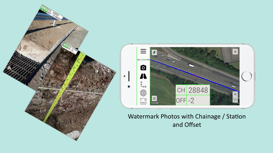
**Watermarked Photos**
Photos can be taken which will then be watermarked with the coordinates of the current location.
Watermark coordinates can be displayed in Chainage/Station and offset, Cartesian East North or Latitude Longitude depending on user preference.
**Cross sections**
Allows the creation of a cross section perpendicular to a given geometric alignment.
Cross section can be updated in real-time (Track mode) or on demand (Search mode).
Cross section mode supports pausing updates, locking scale / transformation and importing ground elevation data.
**Landscape mode**
Perfect for placing on your vehicle dashboard NRG Alignment Viewer landscape mode provides clear and real-time updates to the device position in terms of WGS84, Cartesian EN and Geometric Alignments (Chainage/Station/Meterage) coordinates.
NRG Alignment Viewer provides many user defined preferences to customise your use of our tool.
**Geometric Alignment Configuration Options**
Offset display format: -/+ or Left/Right.
Alignment distance: Change/Station/Meterage.
Alignment format: 10000/10+000.
Decimal places display for Alignment/EN.
**Map Configuration Options**
Enable / Disable real-time map scrolling.
Street, Satellite and Hybrid map types.
Enable / Disable centre point Crosshair.
Enable / Disable distance scale bar.
Select scale bar unit of measurement: Imperial/Metric.
**Cross Section Configuration Options**
Cross section centre Mid-Point or user defined Offset.
User defined scale section / Cross section distance.
Vertical Exaggeration.
Google Elevation segments distance.
Enable / Disable Scale bars.
**Manual**
NRG Alignment Viewer manual can be found at:
http://www.nrgsurveys.co.uk/downloads/alignmentviewer.pdf
It is strongly recommended that new users view the manual to make full use of the NRG Alignment Viewer.
Ảnh chụp màn hình


Tính năng mới
- Phiên bản: 3.55
- Cập nhật:
- Improved app performance for a smoother and faster user experience.
Giá bán
- Hôm nay: $16.99
- Tối thiểu: $9.99
- Tối đa: $16.99
Theo dõi giá
Nhà phát triển
- NRG Surveys Ltd
- Nền tảng: Android Ứng dụng (3) iOS Ứng dụng (2)
- Danh sách: 0 + 0
- Điểm: 0 + 6 ¡
- Xếp hạng: 0
- Đánh giá: 0
- Giảm giá: 0
- Video: 0
- RSS: Đăng ký
Điểm
0 ☹️
Xếp hạng
0 ☹️
Danh sách
0 ☹️
Đánh giá
Hãy là người đầu tiên đánh giá 🌟
Thông tin bổ sung
- Phiên bản: 3.55
- Danh mục:
iOS Ứng dụng›Bản đồ và dẫn đường - HĐH:
iPad,iPhone,iOS 14 trở lên - Kích thước:
104 Mb - Xếp hạng nội dung:
4+ - App Store Xêp hạng:
3.8(6) - Cập nhật:
- Ngày phát hành:
Danh bạ
- Trang web:
 http://www.nrgsurveys.co.uk
- 🌟 Chia sẻ
- App Store
Bạn cũng có thể thích
-
- GPX-Viewer
- iOS Ứng dụng: Bản đồ và dẫn đường Bởi: Kyle Modesitt
- $0.99
- Danh sách: 1 + 0 Xếp hạng: 0 Đánh giá: 0
- Điểm: 0 + 1,642 (4.5) Phiên bản: 3.8.90 Import and view GPS eXchange format (GPX) files. GPX-Viewer offers a customizable display of GPX files exported from many GPS devices and other apps that create GPX files. Import GPX ... ⥯
-
- GPX Viewer PRO
- iOS Ứng dụng: Bản đồ và dẫn đường Bởi: Vectura Games
- $6.99
- Danh sách: 1 + 1 Xếp hạng: 0 Đánh giá: 0
- Điểm: 2 + 200 (4.6) Phiên bản: 1.29.4 Do you have your favourite GPX or KML tracks and routes and want to see them in detail on your iPhone & iPad, or you just want to head into the mountains and record your adventure? No ... ⥯
-
- GPX viewer 2
- iOS Ứng dụng: Bản đồ và dẫn đường Bởi: Jonathan Gander
- Miễn phí
- Danh sách: 0 + 0 Xếp hạng: 0 Đánh giá: 0
- Điểm: 2 + 8 (4.4) Phiên bản: 2.3.1 GPX viewer 2 is the brand new version of my first GPX viewer app! With new features, a new modern user interface and new interactions. I've listened to your needs and built a new app ... ⥯
-
- Gpx Viewer-Converter&Tracking
- iOS Ứng dụng: Bản đồ và dẫn đường Bởi: p swagath
- $3.99
- Danh sách: 0 + 0 Xếp hạng: 0 Đánh giá: 0
- Điểm: 0 + 1 (1.0) Phiên bản: 3.0.3 Gpx Viewer-Gpx Converter-Gpx Tracking(All in one) is an application provides you to load the gpx files, convert gpx files and create gpx track over the map. GPX all in one app is a ... ⥯
-
- KML Viewer-Converter
- iOS Ứng dụng: Bản đồ và dẫn đường Bởi: m sagar
- $2.99
- Danh sách: 0 + 0 Xếp hạng: 0 Đánh giá: 0
- Điểm: 0 + 0 Phiên bản: 1.6.0 KML Viewer-Converter is an application provides you to load the kml files, convert kml files over the map. This app works for offline and online. How to Export or Import .kml files ... ⥯
-
- igc Viewer
- iOS Ứng dụng: Bản đồ và dẫn đường Bởi: Hiroki Kijima
- * Miễn phí
- Danh sách: 0 + 0 Xếp hạng: 0 Đánh giá: 0
- Điểm: 0 + 2 (4.0) Phiên bản: 3.1.12 How to use. - Open File App. (Alternatively, click the share button and open with 'copy to igc viewer') - Select [.igc] file. - The app will open igc file (it might take a few seconds ... ⥯
-
- BlackBox Viewer
- iOS Ứng dụng: Bản đồ và dẫn đường Bởi: (주)이에스브이
- Miễn phí
- Danh sách: 0 + 0 Xếp hạng: 0 Đánh giá: 0
- Điểm: 0 + 1 (5.0) Phiên bản: 1.0.07 BlackBox Viewer is an app that allows you to view the recorded video in real time using the black box's Wi-Fi and control the settings of the black box. Live View: You can view the ... ⥯
-
- Street Viewer plus
- iOS Ứng dụng: Bản đồ và dẫn đường Bởi: Hideshi Otsuru
- Miễn phí
- Danh sách: 0 + 0 Xếp hạng: 0 Đánh giá: 0
- Điểm: 0 + 575 (4.5) Phiên bản: 1.9.61 An app that makes Street View easier to use. Lets you use Street View with compass and screen capture functions. Display the street view by tapping the blue line on the map. Display ... ⥯
-
- Flight Distance Viewer
- iOS Ứng dụng: Bản đồ và dẫn đường Bởi: Pablo Asensio Martinez
- Miễn phí
- Danh sách: 0 + 0 Xếp hạng: 0 Đánh giá: 0
- Điểm: 1 + 0 Phiên bản: 1.0.1 Quickly estimate flight distances between any airports worldwide. Search by IATA/ICAO code or city, visualize the route on an interactive 3D globe, and track the true great-circle ... ⥯
-
- RaceBunny — GPX Viewer
- iOS Ứng dụng: Bản đồ và dẫn đường Bởi: Berbie Software
- Miễn phí
- Danh sách: 0 + 0 Xếp hạng: 0 Đánh giá: 0
- Điểm: 0 + 3 (3.3) Phiên bản: 6.5.1000 ** FREE TRIAL for one week contained in subscription ** RaceBunny is a mobile companion App for TrailRunner mini, a route planning application available on the Mac App Store. ** ... ⥯
-
- REscan Viewer
- iOS Ứng dụng: Bản đồ và dẫn đường Bởi: REscan Inc.
- Miễn phí
- Danh sách: 0 + 0 Xếp hạng: 0 Đánh giá: 0
- Điểm: 0 + 7 (5.0) Phiên bản: 1.3.275 REscan captures indoor and outdoor locations as fast as we walk through them, and turn spaces into streamable 3D models. We make real estates remotely viewable, analyzable, editable, ... ⥯
-
- 리드아이 Viewer
- iOS Ứng dụng: Bản đồ và dẫn đường Bởi: Hyosung Company Corporation
- Miễn phí
- Danh sách: 0 + 0 Xếp hạng: 0 Đánh giá: 0
- Điểm: 0 + 0 Phiên bản: 1.0.7 Leadi is a utility app for Gnet car black box with built-in Wi-Fi. Key features are: - Real-time video display - Search and playback recorded video - Shapshot image or video backup to ... ⥯
-
- Geodata Map Viewer
- iOS Ứng dụng: Bản đồ và dẫn đường Bởi: Jack Finnis
- Miễn phí
- Danh sách: 0 + 0 Xếp hạng: 0 Đánh giá: 0
- Điểm: 0 + 32 (4.3) Phiên bản: 2.2 Your new go-to tool to view any GeoJSON, KML or GPX file on your phone. Completely free with no ads or in-app purchases. KEY FEATURES View any GeoJSON, KML or GPX file on an ... ⥯
-
- GPX KML KMZ Viewer Converter
- iOS Ứng dụng: Bản đồ và dẫn đường Bởi: seawellsoft
- $4.99
- Danh sách: 0 + 0 Xếp hạng: 0 Đánh giá: 0
- Điểm: 0 + 2 (2.0) Phiên bản: 2.1.1 **Seawell GPX KML KMZ is simple to use to display and manage your Point Of Interest. Ease of Use for Everybody! GPX KML KMZ will import .gpx , .kml, .kmz files to show your gps track ... ⥯