| Nhà phát triển: | Bay Ridge Civic Association (2) | ||
| Giá bán: | Miễn phí | ||
| Xếp hạng: | 0 | ||
| Đánh giá: | 0 Viết đánh giá | ||
| Danh sách: | 0 + 0 | ||
| Điểm: | 0 + 5 ¡ | ||
| Điểm + 1 | |||
Mô tả
")
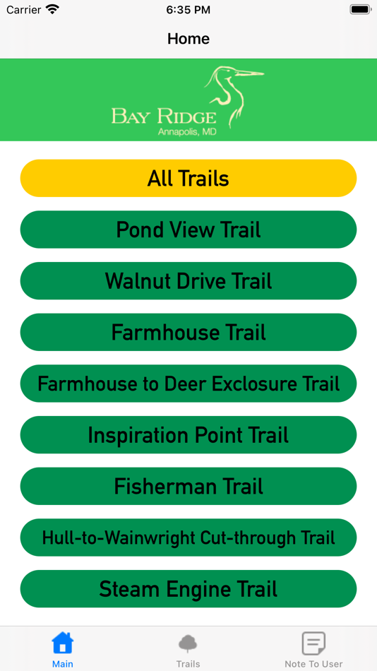
The Bay Ridge Trail App uses the user's location for real-time tracking to guide the user. The user's location is indicated with a blue dot with a light blue circle to signify accuracy. It uses several predefined coordinate points to form a polyline border to outline the trails.
Users can scroll through a list of pre-loaded trails. The user can also select which gallery to view from a picker view. The app draws a white lie and displays the location of the user as a pulsing blue dot.
Included Features:
· Real-time positioning
· Trail list selection and all-trail option
· Picker menu to select picture gallery
· Picture Gallery for each trail and features
· White border polyline for trail paths
· Marker for each QR code in the map
The App GPS real-time location tracker uses the highest location accuracy which may drain phone batteries.
Dear Bay Ridge Resident,
Please keep an eye out for “QR codes” that we have posted along the trails throughout the woods and in the community. Just point your iPhone at the QR codes to conjure up information about special environmental and historical features in Bay Ridge.
A caution and hint about GPS accuracy: your location accuracy using this app, can depend upon several factors, including weather, satellite availability, and your iPhone settings. We have found that the accuracy of this Trails app can be significantly enhanced by downloading, and running in the background, a good free GPS app, such as “My GPS Coordinates". In any event, let this app be your guide, look around and you will see our trails, and watch for those fun QR codes posted along the way. Happy Hiking! Oh, and many thanks to the 2020 South River High School STEM Team for creating this app. -Bay Ridge
This app was developed in 2021 as a Community Challenge Project for the benefit of the Bay Ridge Civic Association by STEM Juniors in South River High School. Rodz Amor developed the app on XCode.
Ảnh chụp màn hình


Tính năng mới
- Phiên bản: 1.1.1
- Cập nhật:
- Added
Added two new trails: Walnut Drive Trail and Steam Engine Trail
Added "Note to User" in App tab and App Store description
Added titles for trail maps
Changed
Changed the color of the trail lines to yellow
Updated coordinate list of Farmhouse Trail and split it into Farmhouse Trail and Farmhouse to Exclosure Trail
Changed coordinate list of Fisherman Trail
Updated the center trail button for the Maps
Removed
Removed QR code pins from the Maps and added Trail Title pins
Removed the "Select Trail" button
Giá bán
- Hôm nay: Miễn phí
- Tối thiểu: Miễn phí
- Tối đa: Miễn phí
Theo dõi giá
Nhà phát triển
- Bay Ridge Civic Association
- Nền tảng: iOS Ứng dụng (2)
- Danh sách: 0 + 0
- Điểm: 0 + 7 ¡
- Xếp hạng: 0
- Đánh giá: 0
- Giảm giá: 0
- Video: 0
- RSS: Đăng ký
Điểm
Không tìm thấy ☹️
Xếp hạng
Không tìm thấy ☹️
Danh sách
Không tìm thấy ☹️
Đánh giá
Hãy là người đầu tiên đánh giá!
Thông tin bổ sung
- Danh mục:
iOS Ứng dụng›Bản đồ và dẫn đường - HĐH:
iPad,iPhone,iOS 14.1 trở lên - Kích thước:
116 Mb - Ngôn ngữ được hỗ trợ:
English - Xếp hạng nội dung:
4+ - App Store Xêp hạng:
3.6(5) - Cập nhật:
- Ngày phát hành:
Bạn cũng có thể thích
-
- Trails Offroad
- iOS Ứng dụng: Bản đồ và dẫn đường Bởi: TRAILS OFFROAD LLC
- * Miễn phí
- Danh sách: 0 + 0 Xếp hạng: 0 Đánh giá: 0
- Điểm: 0 + 138 Phiên bản: 2.7.1 Discover the ultimate off-road trail experience with Trails Offroad, your essential guide to exploring the great outdoors. Whether you're into 4x4, Jeep, Bronco, ATV, or Overlanding ...
-
- USA Lakes and Parks trails
- iOS Ứng dụng: Bản đồ và dẫn đường Bởi: seawellsoft
- Miễn phí
- Danh sách: 0 + 0 Xếp hạng: 0 Đánh giá: 0
- Điểm: 1 + 6 Phiên bản: 1.5 Seawell launches series of Lakes and Parks on to the market with up-to-date maps along with fishing spots and aerial images. For people who are looking for appealing charts, features ...
-
- Boulder Area Trails
- iOS Ứng dụng: Bản đồ và dẫn đường Bởi: Boulder County
- Miễn phí
- Danh sách: 0 + 0 Xếp hạng: 0 Đánh giá: 0
- Điểm: 0 + 31 Phiên bản: 1.2.0 Boulder Area Trails is the OFFICIAL trails app for trails in and around Boulder and Broomfield counties. ** ONE APP FOR ALL THE TRAILS ** Provides a single source for all designated ...
-
- Ohio Trails - DETOUR
- iOS Ứng dụng: Bản đồ và dẫn đường Bởi: Ohio Department of Natural Resources
- Miễn phí
- Danh sách: 0 + 0 Xếp hạng: 0 Đánh giá: 0
- Điểm: 0 + 32 Phiên bản: 2.0.998 Explore and provide feedback on this release of the new DETOUR mobile trails app. Get off the beaten path. Find your DETOUR. This new app will help you discover Ohio's recreational ...
-
- Bikemap: Bike Trails & Tracker
- iOS Ứng dụng: Bản đồ và dẫn đường Bởi: Bikemap GmbH
- * Miễn phí
- Danh sách: 0 + 0 Xếp hạng: 0 Đánh giá: 0
- Điểm: 0 + 8,321 Phiên bản: 29.9.0 Do you love to discover, navigate, and track new cycling routes? Then you'll love Bikemap. It doesn't matter if bicycling for you means a leisurely ride with your city bike or e-bike, ...
-
- Vermont Snowmobile Trails
- iOS Ứng dụng: Bản đồ và dẫn đường Bởi: VERMONT ASSOCATION OF SNOW TRAVELERS INC
- Miễn phí
- Danh sách: 0 + 0 Xếp hạng: 0 Đánh giá: 0
- Điểm: 0 + 19 Phiên bản: 3.4.25 Vermont Association of Snow Travelers is pleased to provide our new, no reception needed, mobile version of our official Trails Map for the 2016-2017 season. Our free app features our ...
-
- Bell Mountain Ranch Trails
- iOS Ứng dụng: Bản đồ và dẫn đường Bởi: Sean Molloy
- Miễn phí
- Danh sách: 0 + 0 Xếp hạng: 0 Đánh giá: 0
- Điểm: 0 + 3 Phiên bản: 1.51 The BMR Trails app helps users of the BMR trail system to navigate the trails with ease. Your current location is shown on a satellite map of the trail system, with every trail marked ...
-
- TrailPass: All Trails GPS Gaia
- iOS Ứng dụng: Bản đồ và dẫn đường Bởi: Polus Apps
- Miễn phí
- Danh sách: 0 + 0 Xếp hạng: 0 Đánh giá: 0
- Điểm: 0 + 3 Phiên bản: 1.2.0 Are you an outdoor enthusiast looking for your next adventure? Do you enjoy exploring new trails for walking, hiking, or cycling? Look no further than TrailPass, the ultimate mobile ...
-
- Draper Utah Trails
- iOS Ứng dụng: Bản đồ và dẫn đường Bởi: City of Draper
- Miễn phí
- Danh sách: 0 + 0 Xếp hạng: 0 Đánh giá: 0
- Điểm: 0 + 3 Phiên bản: 1.1.5 Draper City, Utah has 100+ miles of scenic trails throughout the valley and into Corner Canyon and surrounding mountain ridges. A variety of trails for hiking, mountain biking, ...
-
- Allegheny County Parks Trails
- iOS Ứng dụng: Bản đồ và dẫn đường Bởi: Allegheny County
- Miễn phí
- Danh sách: 0 + 0 Xếp hạng: 0 Đánh giá: 0
- Điểm: 0 + 18 Phiên bản: 4.0 FEATURES You will find new and old trails! Discover trails within each Allegheny County park and easily choose which one to traverse by viewing its length, difficulty, and elevation ...
-
- FunTreks 4x4 Offroad Trails
- iOS Ứng dụng: Bản đồ và dẫn đường Bởi: FunTreks Inc.
- $59.99
- Danh sách: 0 + 0 Xếp hạng: 0 Đánh giá: 0
- Điểm: 0 + 29 Phiên bản: 3.0.4 This app is not intended to be used alone, but rather as a GPS companion to FunTreks 4x4 guidebooks. It contains over 600 of the most popular offroad trails in selected areas of ...
-
- Ride Sledmass Trails
- iOS Ứng dụng: Bản đồ và dẫn đường Bởi: MapGears inc.
- Miễn phí
- Danh sách: 0 + 0 Xếp hạng: 0 Đánh giá: 0
- Điểm: 0 + 11 Phiên bản: 3.0.4 Out exploring on your snowmobile? Take your own mobile trail assistant for the ride! **NEW THIS SEASON** Track your trips: leave breadcrumbs for easier backtracking, get statistics on ...
-
- Topographic Maps & Trails
- iOS Ứng dụng: Bản đồ và dẫn đường Bởi: LW Brands, LLC
- $4.99
- Danh sách: 1 + 0 Xếp hạng: 0 Đánh giá: 0
- Điểm: 1 + 2,623 Phiên bản: 1.4 The #1 Topo Maps App for iOS MAIN FEATURES INCLUDE: - USGS Topographic Maps - USFS Topographic Maps - Satellite + Topo Maps - Hiking Tracker * Download all maps for offline use USGS ...
-
- ModernHiker: California Trails
- iOS Ứng dụng: Bản đồ và dẫn đường Bởi: OPENPLANIT LLC
- Miễn phí
- Danh sách: 0 + 0 Xếp hạng: 0 Đánh giá: 0
- Điểm: 0 + 376 Phiên bản: 2.26 Now you can take the West s most popular hiking blog with you on the trail no internet connection required! Since 2006, Modern Hiker has been providing in-depth trail guides all over ...
Bạn cũng có thể thích
- iOS Ứng dụng
- Mới iOS Ứng dụng
- Bản đồ và dẫn đường iOS Ứng dụng : Mới
- Video iOS Ứng dụng
- Phổ biến iOS Ứng dụng
- Bản đồ và dẫn đường iOS Ứng dụng : Phổ biến
- Giảm giá iOS Ứng dụng
- Bản đồ và dẫn đường iOS Ứng dụng : Giảm giá
- Xếp hạng iOS Ứng dụng
- Đánh giá iOS Ứng dụng
- Danh sách iOS Ứng dụng
- Điểm iOS Ứng dụng