| 開發人員: | CORVALLIS MICROTECHNOLOGY, INC. (19) | ||
| 價錢: | $29.99 | ||
| 排名: | 0 | ||
| 評測: | 0 寫評論 | ||
| 清單: | 0 + 0 | ||
| 點數: | 0 + 1 (5.0) ¡ | ||
| App Store | |||
描述
")
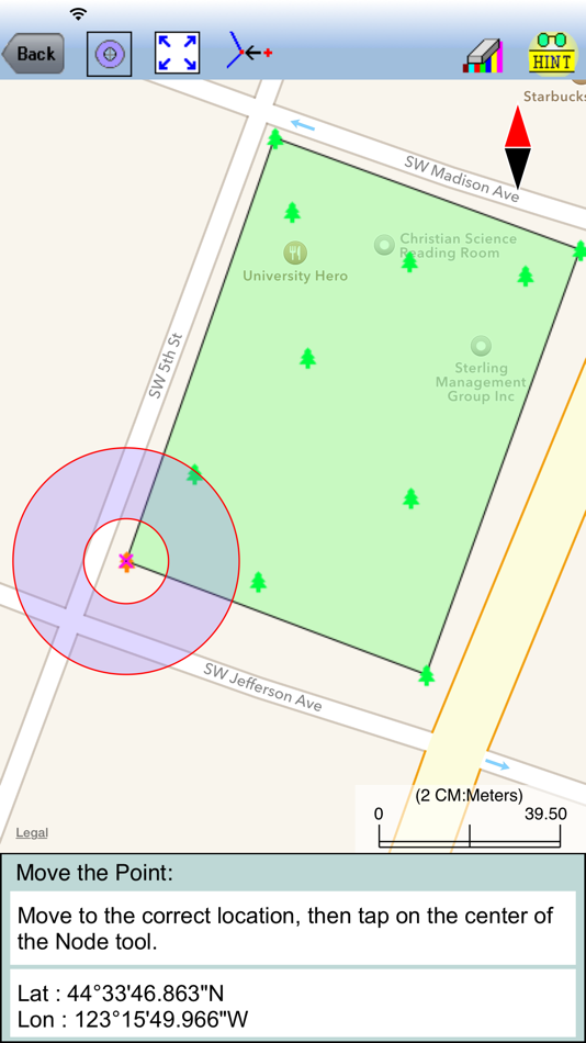
Also use this app to precisely digitize Points, Lines and Areas over the built-in Map and view their locations, lengths and areas. If your device has GPS capability, you may record the GPS location as a Point, or pick the GPS location as a node for the Line or Area you are creating. Location accuracy depends on the accuracy of the GPS receiver used
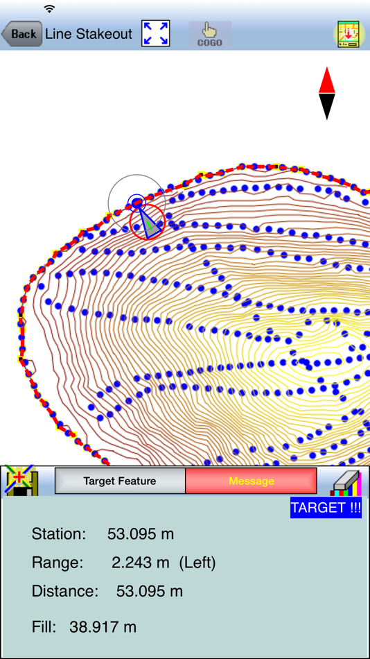
This app provides Point Stakeout and Line Stakeout functions to help you approach a point or move along a line or area boundary.
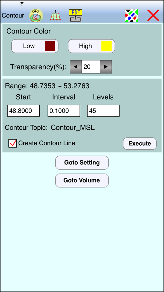
The contour map can be printed to PDF. The contour data can be exported in a text file format. The Feature data can be exported in Shapefiles and DXF formats.
Detailed Function List:
* Import Shapefiles, DXF files and text files.
* Create a grid and generate sampling points.
* Precisely digitize Points, Lines and Areas over the built-in Map.
* Use Point Stakeout and GPS to locate a point or a node on a line.
* Use Line Stakeout and GPS to locate a line.
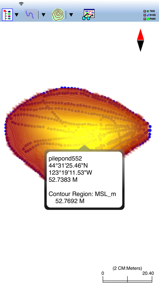
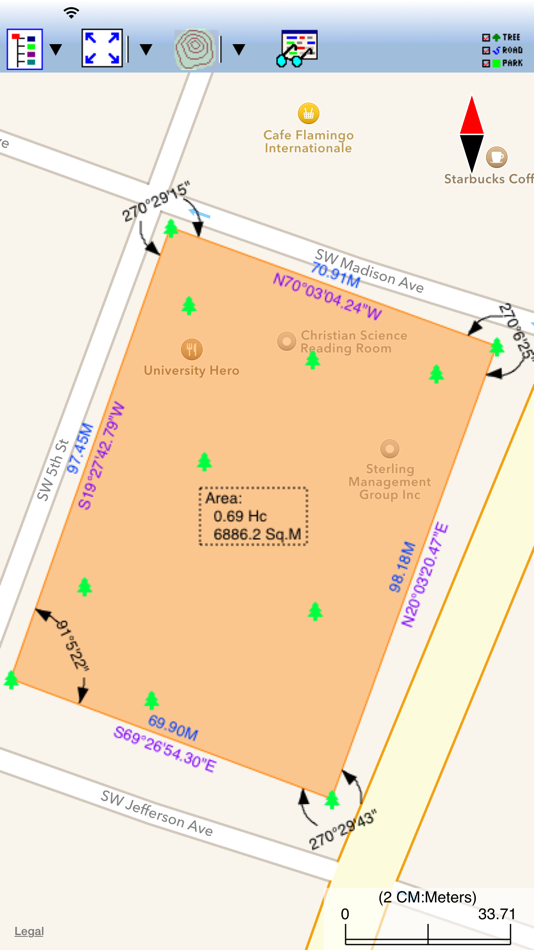
* View position, length and area values for the Features.
* Label the Lines with segment lengths and directions as well as corner angles.
* Label the Areas with size in acres and square feet or hectares and square meters.
* Measure distances and areas without saving the shapes.
* Move existing nodes to fine-tune the map drawing.
* Create a Point from entered coordinates.
* Create a Point or record a node by picking the GPS location.
* Save the job data file for later use.
* Export Feature data to DXF or Shapefiles.
* Export the contour data to a .CSV text file.
* Output the drawing and the coordinates to PDF.
* Email the job data files and the PDF files to your colleagues.
This app comes with a detailed built-in help document.
Please note: Continued use of GPS running in the background can dramatically decrease battery life. This app will let you easily toggle the built-in GPS on or off.
螢幕擷取畫面
價錢
- 今天: $29.99
- 最小值: $29.99
- 最大值: $29.99
追蹤票價
開發人員
- CORVALLIS MICROTECHNOLOGY, INC.
- 平台: iOS 應用程式 (19)
- 清單: 0 + 0
- 點數: 0 + 27 ¡
- 排名: 0
- 評測: 0
- 折扣: 0
- 影片: 0
- RSS: 訂閱
點數
0 ☹️
排名
0 ☹️
清單
0 ☹️
評測
成為第一個評論 🌟
其他資訊
聯絡人
- 個人網站:
 http://www.cmtinc.com
- 🌟 分享
- App Store
你可能還喜歡
-
- Stakeout iCMT
- iOS 應用程式: 地圖與導航 由: CORVALLIS MICROTECHNOLOGY, INC.
- $14.99
- 清單: 0 + 0 排名: 0 評測: 0
- 點數: 0 + 5 (2.6) 版本: 1.0.5 Stakeout iCMT is a handy app that provides functions to help the users perform point stakeout and line stakeout tasks. It will let the user precisely digitize Points, Lines and Areas ... ⥯
-
- Apple Maps
- iOS 應用程式: 地圖與導航 由: Apple
- 免費
- 清單: 3 + 3 排名: 4 (1) 評測: 0
- 點數: 2 + 48,475 (2.4) 版本: 1.9.1 Apple Maps is the best way to navigate and explore the world - all with your privacy protected. What's new: Topographic maps with stunning details like contour lines, hill shading, ... ⥯
-
- Glympse -Share your location
- iOS 應用程式: 地圖與導航 由: Glympse Inc.
- 免費
- 清單: 0 + 0 排名: 0 評測: 0
- 點數: 1 + 48,489 (4.8) 版本: 4.0.22 Glympse makes it easy to temporarily share your live location with friends, family, coworkers, or clients no sign-up required. Whether you're meeting friends, organizing a large event, ⥯
-
- Footpath Route Planner
- iOS 應用程式: 地圖與導航 由: Half Mile Labs LLC
- 免費
- 清單: 2 + 2 排名: 0 評測: 0
- 點數: 1 + 20,531 (4.8) 版本: 4.10.7 Map routes with your finger and Footpath will snap to roads and trails. Measure distances and elevations in seconds, then navigate along with turn-by-turn directions. Footpath is the ... ⥯
-
- i-Boating: Marine Charts & Gps
- iOS 應用程式: 地圖與導航 由: Bist LLC
- 免費
- 清單: 0 + 1 排名: 0 評測: 0
- 點數: 1 + 13,732 (4.5) 版本: 165.0.0 This App offers access to Marine Charts for USA,Canada,UK/Ireland,Germany,Netherlands/Holland & Europe Rivers (Danube,Drava,Rhein etc). Coverage includes NOAA marine vector ... ⥯
-
- Pocket Earth PRO
- iOS 應用程式: 地圖與導航 由: GeoMagik LLC
- $6.99
- 清單: 5 + 4 排名: 0 評測: 0
- 點數: 5 + 1,786 (4.8) 版本: 3.9 Detailed worldwide maps and travel guides Topographic contour maps for the outdoors Works completely offline even with GPS Great when abroad or in the wilderness, NO data roaming ... ⥯
-
- ActiveCaptain®
- iOS 應用程式: 地圖與導航 由: Garmin
- 免費
- 清單: 2 + 0 排名: 0 評測: 0
- 點數: 11 + 4,356 (3.9) 版本: 41.0 The free ActiveCaptain app creates a powerful connection between your compatible mobile device and Garmin chartplotter, charts, maps and the boating community. Whether you use your ... ⥯
-
- Argo - Boating Navigation
- iOS 應用程式: 地圖與導航 由: Argo Navigation, LLC
- * 免費
- 清單: 0 + 1 排名: 0 評測: 0
- 點數: 0 + 5,938 (4.9) 版本: 2.14.3 Argo™ is an easy-to-use navigation and social boating app FREE to download and FREE to use! Find and route to new destinations anywhere in North America, track your boat trips, see ... ⥯
-
- TroutRoutes: Fly Fishing App
- iOS 應用程式: 地圖與導航 由: onXmaps, Inc.
- 免費
- 清單: 0 + 0 排名: 0 評測: 0
- 點數: 3 + 3,706 (4.5) 版本: 5.3.3 TroutRoutes by onX is the #1 GPS mapping tool for trout streams and fly fishing. As the first mapping tool that includes interactive GPS fishing maps for every trout stream in the ... ⥯
-
- Organic Maps: Offline Map
- iOS 應用程式: 地圖與導航 由: Organic Maps
- 免費
- 清單: 1 + 1 排名: 0 評測: 0
- 點數: 3 + 942 (4.8) 版本: 2025.11.26 Organic Maps is a fast, detailed offline map and GPS navigation app for travel, hikes, and rides. Plan, import, and record routes, and enjoy smooth guidance without draining your ... ⥯
-
- TZ iBoat – Marine Navigation
- iOS 應用程式: 地圖與導航 由: Nobeltec, Inc.
- 免費
- 清單: 0 + 0 排名: 0 評測: 0
- 點數: 3 + 770 (4.6) 版本: 3.3.3 Navigate the seas with the most complete marine charts for coastal boating, sailing, and fishing with or without internet. GPS, anchoring, radar, AIS Online, tides & tidal currents... ... ⥯
-
- MapOut
- iOS 應用程式: 地圖與導航 由: Valnova
- $4.99
- 清單: 1 + 1 排名: 0 評測: 0
- 點數: 1 + 131 (4.9) 版本: 3.4.13 MapOut saves the day with its intuitive interface for drawing routes and viewing elevation profiles. I m genuinely impressed by its powerful features! Alee, cyclingabout.com Offline ... ⥯
-
- Desert Maps: Navigator Offline
- iOS 應用程式: 地圖與導航 由: Rachid Smet
- 免費
- 清單: 0 + 0 排名: 0 評測: 0
- 點數: 0 + 135 (4.5) 版本: 5 Desert Maps Your Ideal Companion for Desert and Remote Area Exploration The new and improved version of the Desert Maps app is the perfect guide for all lovers of outdoor adventures, ... ⥯
-
- topoXpress
- iOS 應用程式: 地圖與導航 由: TopoLynx GIS & Mapping Ltd
- 免費
- 清單: 0 + 0 排名: 0 評測: 0
- 點數: 0 + 3 (4.0) 版本: 1.3.1 topoXpress provides the following features: Multiplatform design: the same software with the same rich functionality for both GIS data collectors and Surveyors on iOS & macOS. Handling ⥯