| 開發人員: | Mapnitude Company Limited (14) | ||
| 價錢: | * 免費 | ||
| 排名: | 0 | ||
| 評測: | 0 寫評論 | ||
| 清單: | 0 + 0 | ||
| 點數: | 0 + 5,329 (4.7) ¡ | ||
| 點數 +1 | |||
描述
")
# User-friendly Design
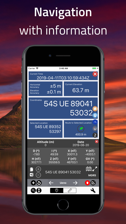
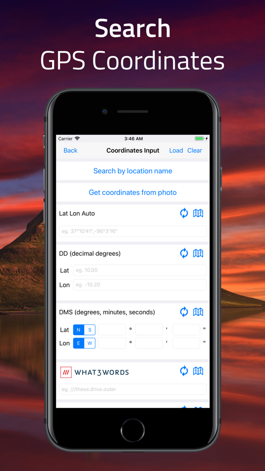
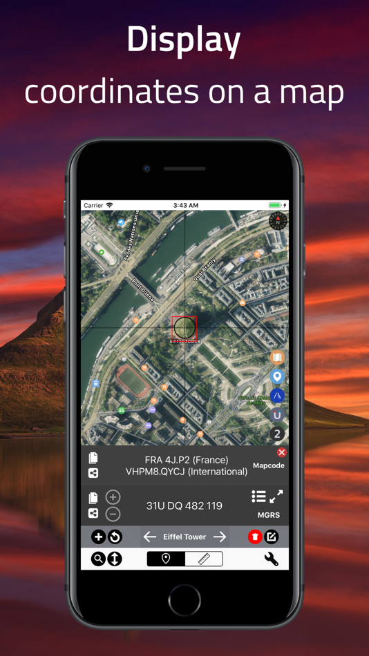
Your current location is displayed at the intersection of two grey lines, with clear latitude and longitude readouts. You can manually set location using map taps, coordinate input, or place search.
Intuitive buttons give quick access to measurement tools, map layers, and location bookmarking — all from a clean, compact interface.
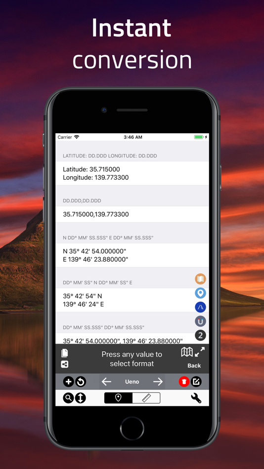
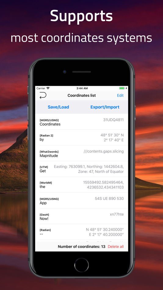
# Various Coordinate Formats
Supports formats like UTM, MGRS, Georef, and more alongside Longitude/Latitude.
# Datum Conversion
Transform coordinates using EPSG, ESRI, and IAU2000 references. Supports X/Y, geodetic, and projected systems.
# Navigation & Tracking
Pin a location or add a label to start navigation. Real-time bearing and distance updates are provided with a large coordinate readout, ideal for on-the-field usage.
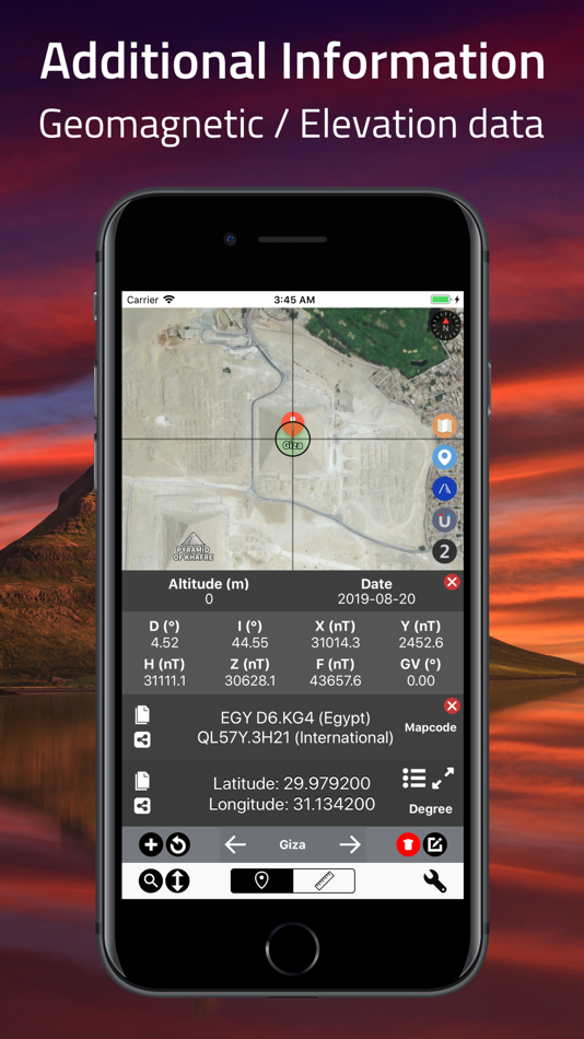
# World Magnetic Model
Uses WMM 2015/WMM 2015v2 to calculate magnetic declination, intensity, and variation.
# Elevation Support
Altitude data is available for land areas.
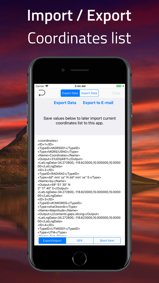
# Import / Export (AirDrop)
- Export current coordinates
- Import backups or shared files
- .gpx .geojson file supported
# Distance, Bearing & Area
Mark points or draw lines to measure distance, bearings, and area.
# PROJ.4 Calculator
Convert coordinates between systems using PROJ.4 cartographic library.
# Offline Map Tiles
Download tiles for offline use. Pick a city or define your own area.
# Custom Map Tile Selector
Choose from Apple Maps, OSM, or add your own tile server with {z}/{x}/{y} format.
# Unit Converter
Convert 40+ unit types (distance, pressure, radiation, etc.)
# Signal Board
Send big bold messages on-screen
# Supported Input / Output #
Latitude and Longitude in
Standard UTM
NATO UTM
MGRS / USNG
Georef
QTH Locator / Maidenhead
(WGS84) World Mercator
(WGS84) Web Mercator
Geohash
what3words
Global Area Reference System (GARS)
Ordnance Survey National Grid [BNG]
OSGB36
ISO 6709
Natural Area Code
Irish Grid Reference / Coordinates
Plus Code (Open Location Code)
Mapcode
Dutch Grid
ECEF
Indian Kalianpur 1975
Open Postcode
Geohash-36
Guatemala GTM
RT90
SWEREF99
Indian 1975
QND95 / Qatar National Grid
IRENET95 / Irish Transverse Mercator
KOSOVAREF01
HD 72 / EOV
Kertau (RSO) / RSO Malaya
Timbalai 1948 / RSO Borneo
EST97 Estonian 1997
LKS92 / Latvia TM
NZGD49
NZGD2000
CH1903/+
GGRS87
ETRS89-extended / LAEA Europe
NTF (Paris) / Lambert zone II
French DFCI Grid
ARINC 424
FMS
ARC1950
Pulkovo 1942 / SK42
PZ-90
H3
Placekey
GDM2000
JGD2011
KUDAMS/KTM
Search by name
Photo metadata
Proj.4 formats
Street Address
# Subscriptions #
“Coordinates – GPS Formatter,” including all of its features, is completely FREE to use. You can subscribe to this application to remove ads
Device subscriptions are available in these plan and will renew automatically each month, six months or year, unless cancelled
(Per month) $2.99
(Per six-months) $15.99
(Per year) $28.99
Price may vary by location. Payment for subscriptions will be charged to your iTunes Account at confirmation of purchase Subscription automatically renews unless auto-renew is turned off at least 24-hours before the end of the current period. Subscriptions may be managed by going to your iTunes Account Settings after purchase or by clicking the “Purchase / Manage Subscription. Auto-renewal may be turned off by going to Account Settings after purchase. Subscription cannot be cancelled during the active subscription period
Privacy policy: https://mapnitude.com/privacy-policy
Terms of use: https://mapnitude.com/terms-of-service
螢幕擷取畫面


新功能
- 版本: 9.6.0
- 發佈日期:
- =============================
Coordinates 9.6.0 Changelog
=============================
- Added image support for pins, labels, and shapes
Now you can attach photos to any map object, view them with EXIF details, and export them alongside your coordinate data.
- Export with images
Exports now include attached images for supported formats, keeping your visual data together with coordinates.
- New: Batch Coordinates Converter
Paste multiple coordinates at once and convert them in bulk, streamlining your workflow.
- New: Convert Pins into Labels, or Labels back into Pins
Flexibly change the type of map items without losing data.
- New: Reselect Shape Style
Easily adjust the color, fill, and stroke of existing shapes for enhanced visual clarity.
價錢
-
* 應用內購買 - 今天: 免費
- 最小值: 免費
- 最大值: 免費
追蹤票價
開發人員
- Mapnitude Company Limited
- 平台: iOS 應用程式 (14)
- 清單: 0 + 0
- 點數: 1 + 13,752 ¡
- 排名: 0
- 評測: 0
- 折扣: 0
- 影片: 0
- RSS: 訂閱
點數
未找到 ☹️
排名
未找到 ☹️
清單
未找到 ☹️
評測
成為第一個評論 🌟
其他資訊
聯絡人
你可能還喜歡
-
- GPS Speedometer: Speed Tracker
- iOS 應用程式: 地圖與導航 由: Mikhail Nikitsin
- * 免費
- 清單: 0 + 0 排名: 0 評測: 0
- 點數: 0 + 4,648 (4.5) 版本: 1.8.0 GPS Speedometer is the most elegant and unique combination of speedometer and trip computer in one application. Just start the application and it will automatically record your speed, ... ⥯
-
- GPS & Maps: Location Tracker
- iOS 應用程式: 地圖與導航 由: Kraus und Karnath GbR 2Kit Consulting
- 免費
- 清單: 0 + 0 排名: 0 評測: 0
- 點數: 1 + 1,898 (4.4) 版本: 4.2 GPS & Maps is a simple, yet powerful GPS app for supporting navigation and outdoor activities like geocaching, sailing, skating, trekking, biking or traveling by airplane. It measures ... ⥯
-
- GPS Speedometer and Odometer
- iOS 應用程式: 地圖與導航 由: Nikhil Kumar
- * 免費
- 清單: 0 + 0 排名: 0 評測: 0
- 點數: 0 + 18,492 (4.8) 版本: 5.1.0 GPS Speedometer and Odometer app is used to measure car, bike, walk, run, boat, bus, train, bicycle and aeroplane speed. GPS Speedometer and Odometer app is used to measure the speed ... ⥯
-
- GPS Area Measure & Land Survey
- iOS 應用程式: 地圖與導航 由: LogiSian Technology Solutions
- * 免費
- 清單: 0 + 0 排名: 0 評測: 0
- 點數: 0 + 2,905 (4.6) 版本: 10.0.0 GPS Area Measure - Mapulator is a powerful measurement app for iPhone designed for professionals and individuals who need field area measurements, GPS measure distance, and land ... ⥯
-
- GPS Navigation Hiking Compass
- iOS 應用程式: 地圖與導航 由: Alexander Deplov
- * 免費
- 清單: 3 + 4 排名: 5 (1) 評測: 0
- 點數: 33 + 2,632 (4.6) 版本: 3.0.1 ** Best New Apps ** Apple ** It s the compass reinvented with walking directions, navigational bookmarks, and a simple parked-car locator all in a friendly design. ** App Store ... ⥯
-
- GPS App - Find family, friends
- iOS 應用程式: 地圖與導航 由: Shubham Kumar
- 免費
- 清單: 0 + 0 排名: 0 評測: 0
- 點數: 1 + 6,776 (4.4) 版本: 4.0.5 Welcome to the all-in-one GPS App! Enjoy modern, advanced tools that go beyond a basic GPS phone tracker. GPS App! allows you to easily share your real-time location or locate friends ... ⥯
-
- GPS Speedometer MPH Tracker
- iOS 應用程式: 地圖與導航 由: BITHAUS.TECH, UNIPESSOAL LDA
- * 免費
- 清單: 0 + 0 排名: 0 評測: 0
- 點數: 0 + 8,781 (4.7) 版本: 6.4.2 Speedometer Speed Tracker GPS is the ideal companion for your driving, biking, boating, or any outdoor adventure involving speed. Carefully designed to cater to your needs, this app ... ⥯
-
- GPS Camera 55. Field Survey
- iOS 應用程式: 地圖與導航 由: Kalimex-Consulting s.r.o. @Blocoware & Stanislav Dvoychenko
- * 免費
- 清單: 1 + 1 排名: 0 評測: 0
- 點數: 0 + 2,318 (4.7) 版本: 4.5 Capture photos with precise location, date, address, and custom notes stamped right on the image. Add hand-drawn annotations for quick markups in the field. Easily search and filter ... ⥯
-
- GPS Navigation & Path Finder
- iOS 應用程式: 地圖與導航 由: Muhammad Asad Khan
- * 免費
- 清單: 0 + 0 排名: 0 評測: 0
- 點數: 0 + 2,807 (4.6) 版本: 8.0.19 This GPS Navigation and Route finder app provide a bunch of functionalities including finding exact route, Direction, Navigation, Nearby Places and many more with Voice functionality. ... ⥯
-
- GPS Location Tracker by number
- iOS 應用程式: 地圖與導航 由: Phone Tracker & Family Link Apps
- * 免費
- 清單: 0 + 0 排名: 0 評測: 0
- 點數: 0 + 816 (3.8) 版本: 6.4 ITrack app is a great way to see exact locations and routes of your relatives and friends and also to log your own ride. Wherever they are it will store their route with minimum ... ⥯
-
- onX Hunt: GPS Hunting Maps
- iOS 應用程式: 地圖與導航 由: onXmaps, Inc.
- * 免費
- 清單: 0 + 0 排名: 0 評測: 0
- 點數: 1 + 233,242 (4.9) 版本: 25.21.0 Navigate your next hunt and view species distribution, topo maps, hunting units, and more. Know where you stand by viewing private and public land ownership data and landowner names. ... ⥯
-
- My Altitude and Elevation GPS
- iOS 應用程式: 地圖與導航 由: MYSTIC MOBILE APPS LLC
- * 免費
- 清單: 0 + 0 排名: 0 評測: 0
- 點數: 0 + 1,101 (4.6) 版本: 6.37 With our app, measuring altitude and elevation is easier than ever. - High-Precision Altitude & Elevation Tracking: Seamlessly monitor your current altitude and elevation with ... ⥯
-
- Trucker Path: Truck GPS & Map
- iOS 應用程式: 地圖與導航 由: Trucker Path Inc.
- * 免費
- 清單: 1 + 0 排名: 0 評測: 0
- 點數: 0 + 114,111 (4.8) 版本: 6.6.8 North America s most popular app for Truckers. BUILT FOR TRUCKERS, BY TRUCKERS! Get all trucker tools in one FREE APP! Best Trucking APP featured by truckers! Trucker Path is a mapping ⥯
-
- Radarbot: Speed Cameras | GPS
- iOS 應用程式: 地圖與導航 由: Iteration Mobile S.L
- * 免費
- 清單: 0 + 0 排名: 0 評測: 0
- 點數: 3 + 95,037 (4.6) 版本: 9.25 Radarbot is the only app that offers real-time alerts and offline detection for speed cameras. Get comprehensive speed camera alerts, real-time traffic updates, and specific speed ... ⥯