| مطوّر البرامج: | OceanBytes Holding LLC (1) | ||
| السعر: | مجاني | ||
| لتصنيفات: | 0 | ||
| المراجعات: | 0 أكتب مراجعة | ||
| قوائم: | 0 + 0 | ||
| النقاط: | 0 + 3 (3.7) ¡ | ||
| App Store | |||
الوصف
")
The Fish Mapping App is included with your SiriusXM Marine Fish Mapping subscription.
With the Fish Mapping App, anglers can view the following features on their phone or tablet:
• Fishing Recommendations
• Weed Lines
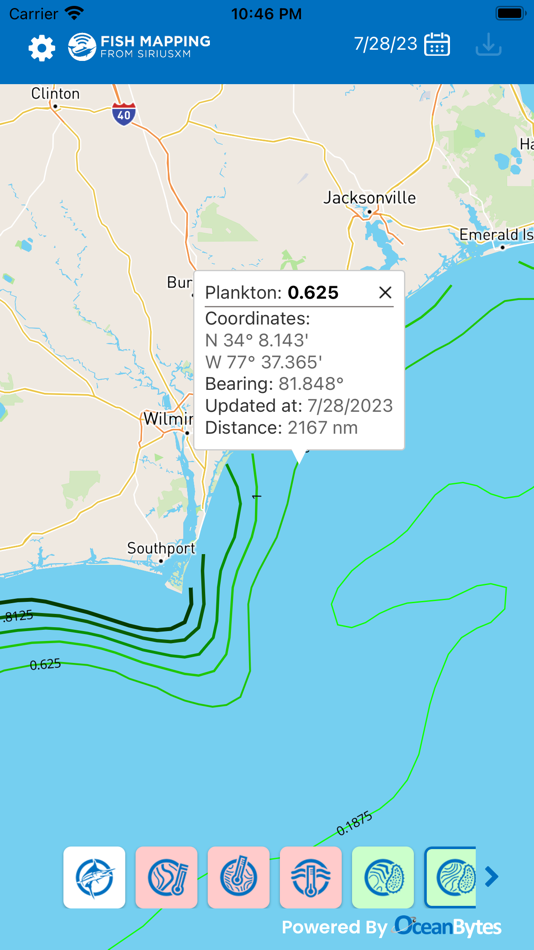
• Plankton Front Strength & Contours
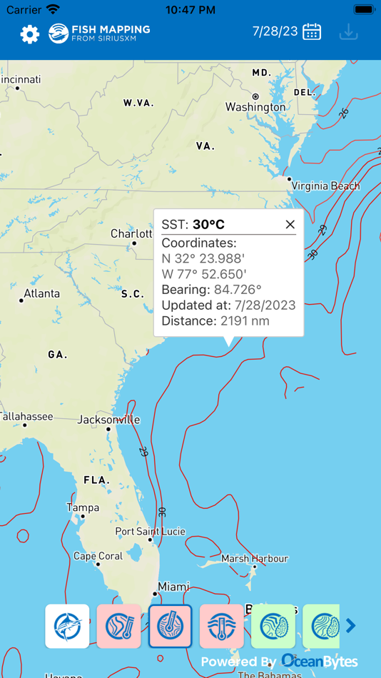
• Sea Surface Temperature Front Strength & Contours
• 30m Sub-Surface Temperatures
• Sea Surface Height Anomalies
• Ocean Currents
• Historical Data
Note: SiriusXM Marine weather features are not available on the Fish Mapping App.
Download the Fish Mapping App now and start using it on your smartphone or tablet to help plan your next fishing trip! App requires internet access.
Not a Fish Mapping subscriber? Learn more at siriusxm.com/fishmapping.
--------------------------
The Fish Mapping App is only available with your Fish Mapping subscription and subscriptions require a compatible satellite-enabled device. The Fish Mapping App is not sold separately. Access to the app may take up to 24 hours from subscription activation to process and access is limited to 2 devices. Internet access is required for the Fish Mapping App. Data rates may apply. Subscription and service fees, content, and features are subject to change.
IMPORTANT INFORMATION: Not all devices are capable of receiving all services offered by SiriusXM. Current information and features may not be available in all locations, or on all receivers. Data displays vary by device; images are representative only. SiriusXM services may include weather and other content and emergency alert information. Such information and data is not for “safety for life,” but is merely supplemental and advisory in nature, and therefore cannot be relied upon as safety critical in connection with any aircraft, seacraft, automobile, or any other usage. SiriusXM is not responsible for any errors or inaccuracies in the data services or their use. See Fish Mapping coverage area at siriusxm.com/marine/coverage-map.
SiriusXM Privacy Policy: www.siriusxm.com/privacy
Your Privacy Choices: www.siriusxm.com/yourprivacychoices
SiriusXM Customer Agreement: www.siriusxm.com/customeragreement
لقطات

الميزات الجديدة
- الإصدار: 3.81.1
- تم التحديث:
- QuickSpot feature is now always enabled for all users.
Removed QuickSpot toggle and related icons.
السعر
- اليوم: مجاني
- الحد الأدنى: مجاني
- الحد الأقصى: مجاني
تتبّع الأسعار
مطوّر البرامج
- OceanBytes Holding LLC
- المنصات: iOS تطبيقات (1)
- قوائم: 0 + 0
- النقاط: 0 + 3 ¡
- لتصنيفات: 0
- المراجعات: 0
- تخفيضات: 0
- أشرطة فيديو: 0
- RSS: اشتراك
النقاط
0 ☹️
لتصنيفات
0 ☹️
قوائم
0 ☹️
المراجعات
كن الأول لمراجعة هذا المنتج 🌟
معلومات إضافية
- الإصدار: 3.81.1
- الفئة:
iOS تطبيقات›التنقل - نظام التشغيل:
iPad,iPhone,iOS 13.4 والأحدث - الحجم:
57 Mb - اللغة المعتمدة:
English - تقييم المحتوى:
4+ - App Store تقييم:
3.7(3) - تم التحديث:
- تاريخ الإصدار:
- 🌟 مشاركة
- App Store
قد يعجبك ايضا
-
- Avenza Maps: Offline Mapping
- iOS تطبيقات: التنقل بواسطة: Avenza Systems Inc.
- مجاني
- قوائم: 0 + 1 لتصنيفات: 0 المراجعات: 0
- النقاط: 0 + 122,892 (4.8) الإصدار: 262 Avenza Maps, #1 app for hiking, biking and all trails. Featuring maps from National Geographic, national parks and more! On your next adventure, stay on track with GPS using offline ... ⥯
-
- NRDS Mobile Mapping ('Āina)
- iOS تطبيقات: التنقل بواسطة: Natural Resource Data Solutions Inc.
- مجاني
- قوائم: 0 + 0 لتصنيفات: 0 المراجعات: 0
- النقاط: 0 + 7 (4.9) الإصدار: 43 Mapping and data collection has never been more easy, accurate, and efficient. Geotag photos, record tracks, save waypoints, trace lines, draw polygons, and so much more with the NRDS ... ⥯
-
- Fishing Maps by Fish Fathom
- iOS تطبيقات: التنقل بواسطة: BOATGLIDER, LLC
- * مجاني
- قوائم: 0 + 0 لتصنيفات: 0 المراجعات: 0
- النقاط: 0 + 14 (4.9) الإصدار: 3.17.3 Fish Fathom: AI-powered fishing with semantic search on thousands of NOAA waypoints, 7-day forecasts, and weather predictions. Captain Brad AI tells you where fish will be. AI FEATURES ⥯
-
- onX Fish: Midwest Lake Finder
- iOS تطبيقات: التنقل بواسطة: onXmaps, Inc.
- مجاني
- قوائم: 0 + 0 لتصنيفات: 0 المراجعات: 0
- النقاط: 0 + 404 (4.3) الإصدار: 25.45.1 Discover new lakes, what s in them, and how to get there for your next day of fishing. onX Fish is now live in Minnesota, Wisconsin, Michigan, North Dakota, Indiana, Ohio, Illinois, ... ⥯
-
- CalTopo: Backcountry Mapping
- iOS تطبيقات: التنقل بواسطة: CalTopo LLC
- مجاني
- قوائم: 0 + 0 لتصنيفات: 0 المراجعات: 0
- النقاط: 0 + 5,994 (4.8) الإصدار: 1.23 Take the best mapping app with you wherever you go with the CalTopo app for iOS. Trusted by professional mountain guides, avalanche educators, and search and rescue teams, CalTopo has ... ⥯
-
- onWater Fish Maps & Forecast
- iOS تطبيقات: التنقل بواسطة: OnWater, LLC
- مجاني
- قوائم: 0 + 0 لتصنيفات: 0 المراجعات: 0
- النقاط: 0 + 2,116 (4.5) الإصدار: 2.9.8 Find New Places to Fish. Track Conditions. Fish Smarter. OnWater helps you discover where to fish, know when it's worth going, and log what works. Built for both fly and conventional ... ⥯
-
- topoXpress
- iOS تطبيقات: التنقل بواسطة: TopoLynx GIS & Mapping Ltd
- مجاني
- قوائم: 0 + 0 لتصنيفات: 0 المراجعات: 0
- النقاط: 0 + 3 (4.0) الإصدار: 1.3.1 topoXpress provides the following features: Multiplatform design: the same software with the same rich functionality for both GIS data collectors and Surveyors on iOS & macOS. Handling ⥯
-
- MapToaster NZ Topo Maps
- iOS تطبيقات: التنقل بواسطة: Integrated Mapping Ltd
- مجاني
- قوائم: 0 + 0 لتصنيفات: 0 المراجعات: 0
- النقاط: 0 + 2 (3.5) الإصدار: 4.0.9 MapToaster for iOS provides New Zealand topo maps with all the rich detail of the LINZ Topo50 and Topo250 topographical maps, helping you plan your expedition and get to the right ... ⥯
-
- Trucker Path: Truck GPS & Map
- iOS تطبيقات: التنقل بواسطة: Trucker Path Inc.
- مجاني
- قوائم: 1 + 0 لتصنيفات: 0 المراجعات: 0
- النقاط: 0 + 126,289 (4.8) الإصدار: 6.8.4 North America s most popular app for Truckers. BUILT FOR TRUCKERS, BY TRUCKERS! Get all trucker tools in one FREE APP! Best Trucking APP featured by truckers! Trucker Path is a mapping ⥯
-
- IndoorGPS Mapper
- iOS تطبيقات: التنقل بواسطة: Oriient New Media inc.
- مجاني
- قوائم: 0 + 0 لتصنيفات: 0 المراجعات: 0
- النقاط: 0 + 0 الإصدار: 2.29.0 * Limited access to pre-registered users. This application enables you to survey new locations for indoor positioning by Oriient. The mapping process collects location data and ... ⥯
-
- HuntWise: A Better Hunting App
- iOS تطبيقات: التنقل بواسطة: Sportsman Tracker
- مجاني
- قوائم: 0 + 0 لتصنيفات: 0 المراجعات: 0
- النقاط: 0 + 66,934 (4.7) الإصدار: 9.3.5 HuntWise provides the ultimate hunting advantage that optimizes your outdoor experience and increases your odds of filling your tag and your freezer every season. Here s how: WEATHER ... ⥯
-
- LandGlide: Find Property Lines
- iOS تطبيقات: التنقل بواسطة: Real Estate Portal USA, LLC
- مجاني
- قوائم: 0 + 0 لتصنيفات: 0 المراجعات: 0
- النقاط: 0 + 54,297 (4.8) الإصدار: 5.4.1 LandGlide® is a premier property data app, giving you the most advanced and comprehensive parcel data, property line maps, and satellite maps. Whether you re a real estate agent, ... ⥯
-
- Marlin: Ultimate Fishing App
- iOS تطبيقات: التنقل بواسطة: INAPPLAB OU
- * مجاني
- قوائم: 0 + 0 لتصنيفات: 0 المراجعات: 0
- النقاط: 0 + 0 الإصدار: 1.4.95 Fish smarter with depth maps, forecasts, and a one-tap logbook. Snap a photo - Marlin suggests species and estimates size and count, then saves it to your log in one tap. Fish at the ... ⥯
-
- Glympse -Share your location
- iOS تطبيقات: التنقل بواسطة: Glympse Inc.
- مجاني
- قوائم: 0 + 0 لتصنيفات: 0 المراجعات: 0
- النقاط: 1 + 48,502 (4.8) الإصدار: 4.0.22 Glympse makes it easy to temporarily share your live location with friends, family, coworkers, or clients no sign-up required. Whether you're meeting friends, organizing a large event, ⥯