| デベロッパー: | Seattle Avionics, Inc. (2) | ||
| 価格: | フリー | ||
| ランキング: | 0 | ||
| レビュー: | 0 レビューを書く | ||
| リスト: | 0 + 0 | ||
| ポイント: | 0 + 71 ¡ | ||
| ポイント + 1 | |||
説明
")
InSight shows incredible views and a simple tap captures the image. Use the Photos tab to view and share your favorite pictures via Facebook, Instagram, Twitter, etc.
Filter by type of airport and distance range.
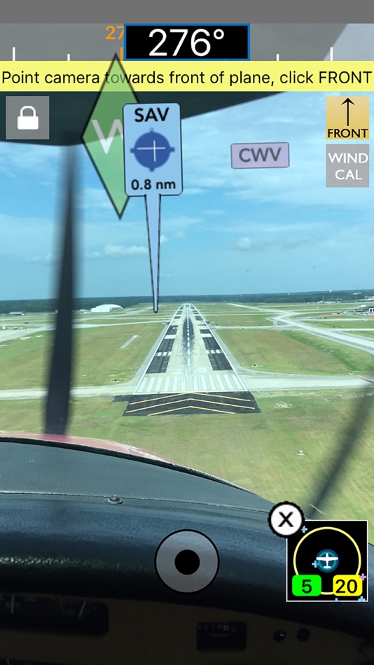
Use the unique 2D view to show a "top down" view of nearby airports in relation to where you're pointing your device.
Not only that, FlyQ InSight has aviation weather, airport info, FBO info, fuel prices, and flight planning capability to put tremendous power just a click or two away. You can plan a flight on your iPhone with an auto-router that wind-optimizes your flight to get you there as fast as possible. Victor Airways, GPS Direct routing, Jet Airways—FlyQ InSight is ready for it all.
FlyQ InSight shares flight plans, pilot profiles, and aircraft profiles with your iPad running FlyQ EFB and your PC or Mac using FlyQ Online.
Using FlyQ InSight is simple because all major functions are always just a tap away.
Airport Information
Start FlyQ InSight and within about 3 seconds it finds the nearest airports and displays succinct weather, fuel, and operational details about them—without even tapping a button. Or use the Search feature to find airports by ident or name. Even browse by state/city to select airports without typing. Want more info about an airport? Tap and all the details you need (but no excess clutter) appears instantly. On the first airport page, you immediately see operational information, fuel prices, runways, navaids, the FAA airport diagram (if applicable) and an embedded satellite map image of the airport. Want to call the local ATIS? Tap the phone number and your iPhone quickly connects you. Tap the weather tab and see the current temperature and sky conditions, a Nexrad radar image of the area, the nearest METARs and TAFs, winds-aloft, and even an official Lockheed Martin or DUATS weather briefing. One tap zooms the METARs, TAFs and weather graphics to full screen, large font versions that anyone can read—even in turbulence. Another tap gives you an easy-to-read 7 day forecast. Quickly find the FBO details you need—fuel information, telephone numbers, rental cars, nearby attractions and more. The Favorites feature gives quick access to commonly-used airports.
Weather Information
Tap the Weather tab and FlyQ InSight instantly locks on to your GPS position and displays temperature, Nexrad images and local METARs and TAFs. Or choose from a large gallery of US and Canadian weather graphics, many of which are animated. Quickly check the weather anywhere on the globe by entering an airport ident, city name, even a zip code. Of course, FlyQ InSight keeps track of your recent selections for quick future access and stores graphics and METARs/TAFs on the phone so they’re available even when you’re not connected to the Internet (such as in flight).
Flight Planning
No time to plan a flight? Give us 30 seconds and watch FlyQ InSight assemble the perfect wind-optimized flight plan. Tell FlyQ InSight where to depart, where to land, and how to fly there (Victor airways, Jet Airways or GPS Direct) and FlyQ InSight plots the whole course including all the navaids and intersection—not a simple straight line. It even uses the winds-aloft forecast to give you the ideal altitude for each leg of your trip. To make your life easier, FlyQ InSight automatically requests an official Lockheed Martin or DUATS weather briefing so you’re good to go. Filing the flight plan takes one tap and about 3 seconds. FlyQ InSight remembers your recent flights and home airport so you can often plan a flight by picking from a list of recently used airports rather than typing.
スクリーンショット


新機能
- バージョン: 4.0.2
- アップデート:
- Bug fixes for iOS 11 and other minor issues.
価格
- 今日: フリー
- 最小値: フリー
- 最大: フリー
料金のチェック
デベロッパー
- Seattle Avionics, Inc.
- プラットフォーム: iOS アプリ (2)
- リスト: 0 + 0
- ポイント: 1 + 629 ¡
- ランキング: 0
- レビュー: 0
- 割引: 0
- 動画: 0
- RSS: 購読する
ポイント
見つかりませんでした ☹️
ランキング
見つかりませんでした ☹️
リスト
見つかりませんでした ☹️
レビュー
最初のクチコミを書こう!
情報
- カテゴリ:
iOS アプリ›ナビゲーション - オペレーティング システム:
Apple Watch,iPad,iPhone,iOS 8.0 以上 - サイズ:
113 Mb - サポートされる言語:
English - コンテンツのレーティング:
4+ - App Store 評価:
3.9(71) - アップデート:
- リリース日:
連絡先
あなたも好きかも
-
- Fly Virga
- iOS アプリ: ナビゲーション 作者: Aviation Apps, LLC
- フリー
- リスト: 0 + 0 ランキング: 0 レビュー: 0
- ポイント: 0 + 17 バージョン: 1.57 Pilots can now unleash the power of real time PIREPs for flight planning, management and safety. Virga is aviation s only app that allows pilots to submit PIREPs without the need for ...
- 新着
- Trout Stream GPS - Fly Fishing
- iOS アプリ: ナビゲーション 作者: Distal Industries, LLC
- * フリー
- リスト: 0 + 0 ランキング: 0 レビュー: 0
- ポイント: 0 + 3 バージョン: 6.0 WHAT IS TROUT STREAM GPS? Trout Stream GPS shows you where to park and fish on America's trout streams. The app is free to download, and maps are available for in-app purchase. FLY ...
-
- TroutRoutes: Fly Fishing Maps
- iOS アプリ: ナビゲーション 作者: Trout Insights, LLC
- * フリー
- リスト: 0 + 0 ランキング: 0 レビュー: 0
- ポイント: 0 + 3,053 バージョン: 5.0.13 TroutRoutes is the #1 GPS mapping tool for trout streams and fly fishing. It is the industry's first mapping tool that includes interactive GPS fishing maps for every trout stream in ...
-
- Holding Pattern Computer
- iOS アプリ: ナビゲーション 作者: Aviation Mobile Apps, LLC.
- $11.99
- リスト: 0 + 0 ランキング: 0 レビュー: 0
- ポイント: 0 + 167 バージョン: 3.0.2 Fly with Confidence: Holding Pattern App Elevate your flying skills with Version 3.0 of the Holding Pattern App, meticulously crafted by aerospace experts. Ideal for both new and ...
-
- Drone Assist - Flight Planning
- iOS アプリ: ナビゲーション 作者: Altitude Angel Ltd
- フリー
- リスト: 0 + 0 ランキング: 0 レビュー: 0
- ポイント: 0 + 5 バージョン: 2.3.119973 Plan and submit your drone flights, check the weather, fly safely, and be in control with Drone Assist, the industry s most trusted drone flight situational awareness source. Do your ...
-
- Xavion
- iOS アプリ: ナビゲーション 作者: X-Avionics, LLC
- * フリー
- リスト: 0 + 0 ランキング: 0 レビュー: 0
- ポイント: 0 + 98 バージョン: 3.41 In flight, Xavion constantly imagines engine-failed glides to every runway in gliding range, and then shows you the safest-possible route as a Highway-In-The-Sky to take to an airport ...
-
- D-Space
- iOS アプリ: ナビゲーション 作者: Marco Tricarico
- * フリー
- リスト: 0 + 0 ランキング: 0 レビュー: 0
- ポイント: 3 + 0 バージョン: 3.1.7 It is the first entirely Italian app that helps the SAPR pilot or the simple drone enthusiast to understand where he can fly and what kind of permissions are needed to do so. The app ...
-
- 13:20:Sync - DB
- iOS アプリ: ナビゲーション 作者: The RedHouse Apps
- $3.99
- リスト: 0 + 0 ランキング: 0 レビュー: 0
- ポイント: 0 + 21 バージョン: 2.5 This app provides a simple way to sync along the cycles of time, to raise our frequency and give us a new lens to view both our day-to-day and planetary events. Natural time is ...
-
- Nav Trainer Pro
- iOS アプリ: ナビゲーション 作者: FLEMINGER MEDIA LLC
- $8.99
- リスト: 0 + 0 ランキング: 0 レビュー: 0
- ポイント: 0 + 35 バージョン: 3.5.0 Selected by AOPA.org readers as number one of five aviation apps you can't live without! * Reached No. 4 in the Navigation category of the U.S. app store for iPad! Make IFR flight ...
-
- Scenic Map Alaska
- iOS アプリ: ナビゲーション 作者: GrangerFX
- $1.99
- リスト: 0 + 0 ランキング: 0 レビュー: 0
- ポイント: 0 + 4 バージョン: 1.9.2 A 3D topo map of State of Alaska, USA. The vector map data is contained within the app and can be used without an internet connection. Use it in a car, a boat, a plane or while hiking.
-
- Truck Parking Europe
- iOS アプリ: ナビゲーション 作者: Truckparking B.V.
- フリー
- リスト: 0 + 0 ランキング: 0 レビュー: 0
- ポイント: 0 + 63 バージョン: 4.0.2 Looking for a (secure) truck parking or truck stop? The Truck Parking Europe app offers you the largest free app for truck parking facilities. Find your next truck parking location in ...
-
- PathAway Outdoor Navigation
- iOS アプリ: ナビゲーション 作者: MuskokaTech Inc.
- $4.99
- リスト: 0 + 0 ランキング: 0 レビュー: 0
- ポイント: 0 + 5 バージョン: 6.78.14 Enjoy hours of outdoor fun with PathAway guiding, and tracking your way! Mark points of interest, with details or photos at those special spots along your route! Navigate with free ...
-
- Air Navigation Pro
- iOS アプリ: ナビゲーション 作者: Xample Sarl
- * フリー
- リスト: 0 + 1 ランキング: 0 レビュー: 0
- ポイント: 2 + 550 バージョン: 8.3.370 Discover our flight planning & real-time navigation app for free for 28 days! - Everything you need to fly around the world - Plan your flight in a few minutes - Fly relaxed with ...
-
- RT-Nav
- iOS アプリ: ナビゲーション 作者: Hilton's Fishing Charts, L.L.C.
- フリー
- リスト: 0 + 0 ランキング: 0 レビュー: 0
- ポイント: 0 + 7 バージョン: 1.0743 Hilton's Realtime-Navigator Mobile Navigation Application. Navigate on almost real-time imageries such as sea surface temperatures, chlorophyll, surface currents, altimetry, and ...