| 開發人員: | Seattle Avionics, Inc. (2) | ||
| 價錢: | 免費 | ||
| 排名: | 0 | ||
| 評測: | 0 寫評論 | ||
| 清單: | 0 + 0 | ||
| 點數: | 0 + 79 (3.8) ¡ | ||
| App Store | |||
描述
")
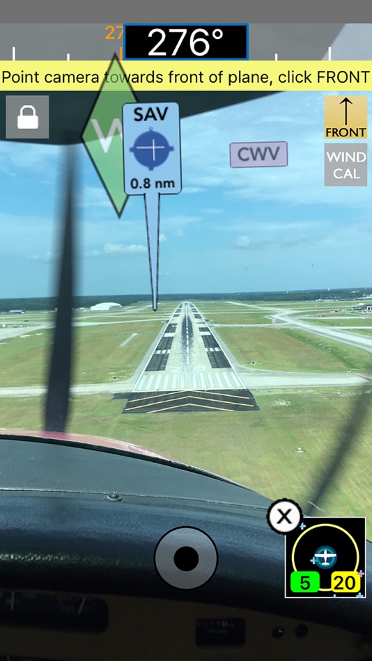
InSight shows incredible views and a simple tap captures the image. Use the Photos tab to view and share your favorite pictures via Facebook, Instagram, Twitter, etc.
Filter by type of airport and distance range.
Use the unique 2D view to show a "top down" view of nearby airports in relation to where you're pointing your device.
Not only that, FlyQ InSight has aviation weather, airport info, FBO info, fuel prices, and flight planning capability to put tremendous power just a click or two away. You can plan a flight on your iPhone with an auto-router that wind-optimizes your flight to get you there as fast as possible. Victor Airways, GPS Direct routing, Jet Airways—FlyQ InSight is ready for it all.
FlyQ InSight shares flight plans, pilot profiles, and aircraft profiles with your iPad running FlyQ EFB and your PC or Mac using FlyQ Online.
Using FlyQ InSight is simple because all major functions are always just a tap away.
Airport Information
Start FlyQ InSight and within about 3 seconds it finds the nearest airports and displays succinct weather, fuel, and operational details about them—without even tapping a button. Or use the Search feature to find airports by ident or name. Even browse by state/city to select airports without typing. Want more info about an airport? Tap and all the details you need (but no excess clutter) appears instantly. On the first airport page, you immediately see operational information, fuel prices, runways, navaids, the FAA airport diagram (if applicable) and an embedded satellite map image of the airport. Want to call the local ATIS? Tap the phone number and your iPhone quickly connects you. Tap the weather tab and see the current temperature and sky conditions, a Nexrad radar image of the area, the nearest METARs and TAFs, winds-aloft, and even an official Lockheed Martin or DUATS weather briefing. One tap zooms the METARs, TAFs and weather graphics to full screen, large font versions that anyone can read—even in turbulence. Another tap gives you an easy-to-read 7 day forecast. Quickly find the FBO details you need—fuel information, telephone numbers, rental cars, nearby attractions and more. The Favorites feature gives quick access to commonly-used airports.
Weather Information
Tap the Weather tab and FlyQ InSight instantly locks on to your GPS position and displays temperature, Nexrad images and local METARs and TAFs. Or choose from a large gallery of US and Canadian weather graphics, many of which are animated. Quickly check the weather anywhere on the globe by entering an airport ident, city name, even a zip code. Of course, FlyQ InSight keeps track of your recent selections for quick future access and stores graphics and METARs/TAFs on the phone so they’re available even when you’re not connected to the Internet (such as in flight).
Flight Planning
No time to plan a flight? Give us 30 seconds and watch FlyQ InSight assemble the perfect wind-optimized flight plan. Tell FlyQ InSight where to depart, where to land, and how to fly there (Victor airways, Jet Airways or GPS Direct) and FlyQ InSight plots the whole course including all the navaids and intersection—not a simple straight line. It even uses the winds-aloft forecast to give you the ideal altitude for each leg of your trip. To make your life easier, FlyQ InSight automatically requests an official Lockheed Martin or DUATS weather briefing so you’re good to go. Filing the flight plan takes one tap and about 3 seconds. FlyQ InSight remembers your recent flights and home airport so you can often plan a flight by picking from a list of recently used airports rather than typing.
螢幕擷取畫面


價錢
- 今天: 免費
- 最小值: 免費
- 最大值: 免費
追蹤票價
開發人員
- Seattle Avionics, Inc.
- 平台: iOS 應用程式 (2)
- 清單: 0 + 0
- 點數: 1 + 928 ¡
- 排名: 0
- 評測: 0
- 折扣: 0
- 影片: 0
- RSS: 訂閱
點數
0 ☹️
排名
0 ☹️
清單
0 ☹️
評測
成為第一個評論 🌟
其他資訊
- 版本: 4.0.2
- 類別 :
iOS 應用程式›地圖與導航 - OS:
Apple Watch,iPad,iPhone,iOS 8.0 以上版本 - 大小:
113 Mb - 支援的語言 :
English - 內容分級:
4+ - App Store 評分:
3.8(79) - 發佈日期:
- 發行日期:
- 🌟 分享
- App Store
你可能還喜歡
-
- Fly Baby: Navigate in Style
- iOS 應用程式: 地圖與導航 由: Kyle Ramirez
- $2.99
- 清單: 0 + 0 排名: 0 評測: 0
- 點數: 0 + 0 版本: 1.2 Fly Baby is a set of premium cockpit navigation instruments and waypoint info that stays on your wrist wherever you go, giving you the ability to navigate to any destination across the ⥯
-
- Fly Virga
- iOS 應用程式: 地圖與導航 由: Aviation Apps, LLC
- 免費
- 清單: 0 + 0 排名: 0 評測: 0
- 點數: 0 + 18 (3.7) 版本: 1.57 Pilots can now unleash the power of real time PIREPs for flight planning, management and safety. Virga is aviation s only app that allows pilots to submit PIREPs without the need for ... ⥯
-
- Fly Local
- iOS 應用程式: 地圖與導航 由: Studio BabDreams
- 免費
- 清單: 0 + 0 排名: 0 評測: 0
- 點數: 0 + 0 版本: 1.1.1 Compute a safe altitude for your glider plane on a local flight. The app uses the GPS to display your relative position to an airfield and compute a safe glide altitude according to ... ⥯
-
- TroutRoutes: Fly Fishing App
- iOS 應用程式: 地圖與導航 由: onXmaps, Inc.
- * 免費
- 清單: 0 + 0 排名: 0 評測: 0
- 點數: 3 + 3,715 (4.5) 版本: 5.3.4 TroutRoutes by onX is the #1 GPS mapping tool for trout streams and fly fishing. As the first mapping tool that includes interactive GPS fishing maps for every trout stream in the ... ⥯
-
- Trout Stream GPS - Fly Fishing
- iOS 應用程式: 地圖與導航 由: Distal Industries, LLC
- * 免費
- 清單: 0 + 0 排名: 0 評測: 0
- 點數: 0 + 3 (2.7) 版本: 6.0 WHAT IS TROUT STREAM GPS? Trout Stream GPS shows you where to park and fish on America's trout streams. The app is free to download, and maps are available for in-app purchase. FLY ... ⥯
-
- GeoSnap Insight
- iOS 應用程式: 地圖與導航 由: Hanva,LLC
- * 免費
- 清單: 0 + 0 排名: 0 評測: 0
- 點數: 0 + 0 版本: 1.1 GeoSnap Insight - Unleash the Power of AI and Explore the World Through Your Photos! Discover the hidden secrets of your photos with GeoSnap Insight! This innovative app leverages ... ⥯
-
- Spartan Tracker UK
- iOS 應用程式: 地圖與導航 由: Fly delivery ltd
- 免費
- 清單: 0 + 0 排名: 0 評測: 0
- 點數: 0 + 0 版本: 3.1.0 Fleets management compatible portal and report systems you are ready to track a There s almost no learning curve for Spartan Tracker users. Our customers tell us that the easy-to-use ... ⥯
-
- Visual Intelligence Platform
- iOS 應用程式: 地圖與導航 由: Geospatial Insight Ltd
- 免費
- 清單: 0 + 0 排名: 0 評測: 0
- 點數: 1 + 0 版本: 1.0.27-34_PROD Take your geospatial data mobile with VIP. Designed with speed and security in mind, VIP allows you to access you VIP workspaces anywhere with your connected mobile or tablet so that ... ⥯
-
- Moovit: Bus & Transit Tracker
- iOS 應用程式: 地圖與導航 由: Moovit App Global LTD
- 免費
- 清單: 1 + 0 排名: 0 評測: 0
- 點數: 1 + 54,196 (4.6) 版本: 5.181.0 Transform the way you navigate your city with Moovit, the all-in-one app for urban transit. Whether you re taking the bus, subway, train, or even hopping on a dockless scooter, Moovit ... ⥯
-
- LandGlide: Find Property Lines
- iOS 應用程式: 地圖與導航 由: Real Estate Portal USA, LLC
- 免費
- 清單: 0 + 0 排名: 0 評測: 0
- 點數: 0 + 54,473 (4.8) 版本: 5.4.1 LandGlide® is a premier property data app, giving you the most advanced and comprehensive parcel data, property line maps, and satellite maps. Whether you re a real estate agent, ... ⥯
-
- Holding Pattern Computer
- iOS 應用程式: 地圖與導航 由: Aviation Mobile Apps, LLC.
- $11.99
- 清單: 0 + 0 排名: 0 評測: 0
- 點數: 0 + 176 (4.9) 版本: 3.0.2 Fly with Confidence: Holding Pattern App Elevate your flying skills with Version 3.0 of the Holding Pattern App, meticulously crafted by aerospace experts. Ideal for both new and ... ⥯
-
- Tracerlink
- iOS 應用程式: 地圖與導航 由: Vojtech Vondra
- $9.99
- 清單: 0 + 0 排名: 0 評測: 0
- 點數: 0 + 1 (3.0) 版本: 2.0 Fly heads-up and stay in lift with an ultra-lightweight, wrist-only setup. Tracerlink connects your UltraBip, BlueBip or XC Tracer to Apple Watch and shows live flight data with haptic ⥯
-
- Yandex Navi – navigation, maps
- iOS 應用程式: 地圖與導航 由: Direct Cursus Computer Systems Trading
- * 免費
- 清單: 0 + 1 排名: 0 評測: 0
- 點數: 2 + 18,016 (4.7) 版本: 26.9.3 Yandex Navigator is the perfect companion for drivers. It helps you find your way around the city with fast, convenient directions that avoid traffic jams and road closures. If road ... ⥯
-
- Route4Me Route Planner
- iOS 應用程式: 地圖與導航 由: Route4Me Inc
- 免費
- 清單: 0 + 0 排名: 0 評測: 0
- 點數: 2 + 11,618 (4.6) 版本: 14.9.4 Get home early and in a good mood! Route4Me s mobile route planning app creates simple, stress-free routes for you in seconds. In-app, voice-guided navigation right in the route ... ⥯