描述
")
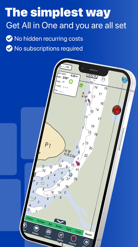
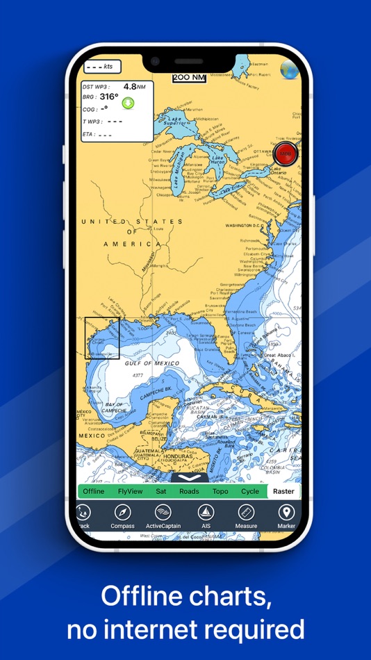
► The charts downloaded are resident in the app. No internet connection required!
Flytomap All In One HD works on all Apple devices
FlyToMap™ offers a revolutionary app; you can download any chart worldwide (500+) free of charge
Check out your area on viewer.flytomap.com
- All USA Marine charts (US All, East, West, Great Lakes, Major Rivers, Florida, Texas, California, etc.)
- USA Lake Maps 15000+ : Minnesota, Maine, Michigan, Massachusetts, Wisconsin, Texas, California, Florida, Iowa, North and South Dakota...and many more.
- 150+ USA Parks and Forests
- Australia Marine Charts
- Australia Parks
- New Zealand Marine charts
- All Europe Marine Charts
- 200+ major EU Parks
- The world's most famous holiday destinations ie: Caribbean, Seychelles, Mauritius, Maldives, Canary Islands, Azores, Bora Bora, Bali, Oslo Fjord .. and many more.
- Canada Lake Maps: Alberta, Lake of the Wood.. and many more.
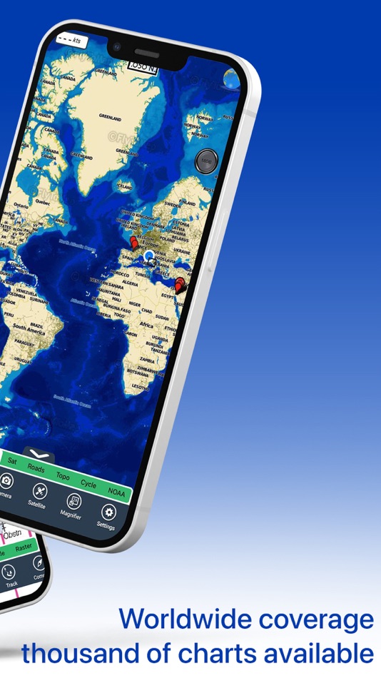
► Worldwide Marine and Outdoor Maps available, thanks to viewer.flytomap.com
► Worldwide Satellite images overlay on charts
► Worldwide Terrain features overlay on charts, thanks to Open Street Map, Open Cycle Map, Bing, Earth, GMap
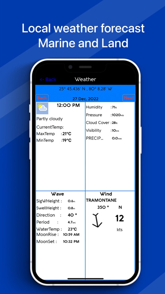
► Interactive Weather forecast
► NOAA raster charts seamless with continuous updates from the official Government server
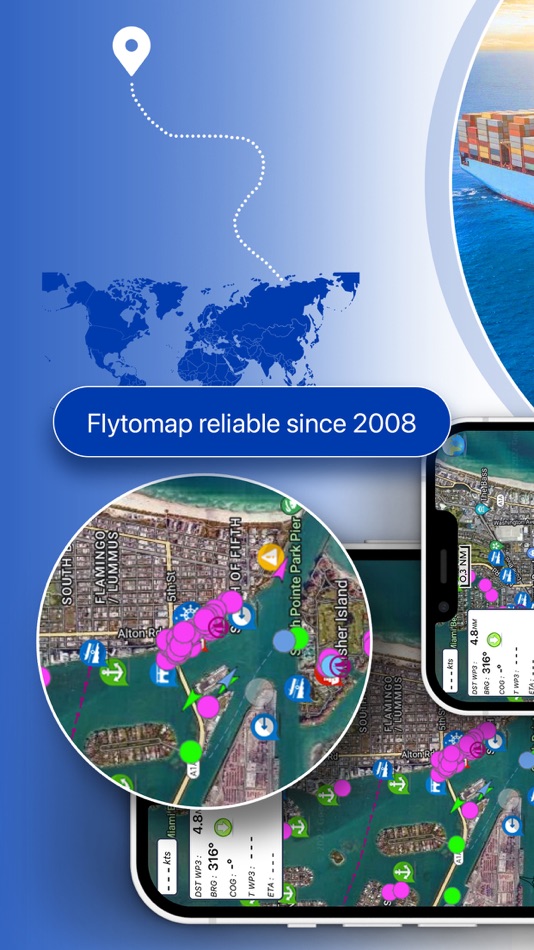
► ActiveCaptain - Worldwide boaters community, with 200.000 + Captains
Use to Explore:
√ Latitudes and Longitudes to go to your favorite places
√ Search your Favorite points directly
√ Zoom, Rotate and Pan fast just by a finger touch
√ Quick Object information just tapping, thanks to vector technology
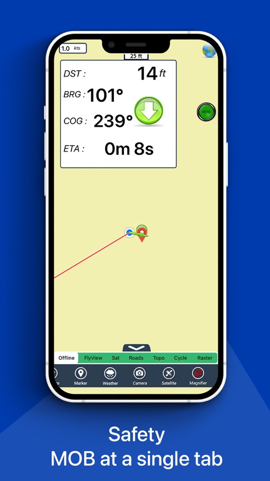
√ GPS Heading Vector Towards the direction movement
√ Distance Measurement Tool to easily calculate the distance from one location to another
√ Route planning, unlimited Waypoints - Insert the target/destination and see in real time your speed, distance and bearing
√ Magnified Lens for all info
√ Unlimited Tracks, Markers, Geo-tagged photos, records and share via email, visible on Google, Flytomap Viewer, KMZ format - Store your track without the need of cellular data or mobile signal
√ Select Depth Contours
√ a la carte menu
√ iOS background mode - Flytomap works in background as well, you can swap with another app and receive/make calls send sms while track recording.
√ Optimized battery usage
√ And so much more to come - It’s the only app you will ever need! Our charts are installed on: NAVICO LOWRANCE B&G NORTHSTAR EAGLE SIMRAD
Follow us:
▶ Twitter @flytomap
▶ Web Site flytomap.com
▶ Facebook facebook.com/flytomap
FlytoMap™ has a wide range of Applications and Maps for you to use - Free of charge on Flytomap All In One !
- WATER MAPS
Electronic Nautical Charts with the same accuracy and detail as on your chart plotter. Maps include Coastline, Anchoring areas, Fishing areas, Restriction areas, Obstructions, Rocks, Buoys, Beacons, Lights, Depth contours, Spot Soundings and more.
- LAKE MAPS
High quality lake maps with detailed information: Depth Contours, Boat Ramps, Fishing spots etc. Maps also include Trails, Roads and Railways information.
- PARK MAPS:
Extremely advanced electronic charts with information collected from National/State Park and Forest Services and many other local sources. The maps contain trails (Hiking, Biking, Equestrian trails etc.,) and Points of interest (POI) like Campgrounds, Visitor Centers, Lookout points, Eating places, Ranger Stations, Picnic areas, Boat/Canoe ramps, Parking areas etc..
- TRAVEL MAPS
These Maps cover the most interesting touristic areas combining Sea and Land information to allow you a complete travel experience.
螢幕擷取畫面


價錢
-
* 應用內購買 - 今天: $14.99
- 最小值: 免費
- 最大值: $19.99
追蹤票價
點數
-

- 4,778 Chuchi Flores
- +1
-
- 2,099 Luciole
- +1
-
- 153 Samson
- +1


排名
0 ☹️
清單
0 ☹️
評測
成為第一個評論 🌟
其他資訊
- 版本: 6.5.11
- 類別 :
iOS 應用程式›地圖與導航 - OS:
Apple Watch,iPad,iPhone,iOS 14 以上版本 - 大小:
128 Mb - 支援的語言 :
English,French,German,Italian,Portuguese,Spanish - 內容分級:
4+ - App Store 評分:
3.3(4) - 發佈日期:
- 發行日期:
聯絡人
- 🌟 分享
- App Store
你可能還喜歡
- -50%
- One Tribe: Offline Location
- iOS 應用程式: 地圖與導航 由: One Date Private Limited
- ▼ $4.99
$9.99-50% - 清單: 0 + 0 排名: 0 評測: 0
- 點數: 1 + 0 版本: 1.0 Never lose track of your friends even without internet. One Tribe lets you share and see your tribe s location offline using Bluetooth. Perfect for travelers, hikers, festival-goers, ... ⥯
-
- One Energy EV
- iOS 應用程式: 地圖與導航 由: One Energy Group
- 免費
- 清單: 0 + 0 排名: 0 評測: 0
- 點數: 0 + 0 版本: 2.5.7 【Product Features】 One Energy can provide an efficient, convenient and safe battery swap services for LEVs users, including two-wheeled, three-wheeled, four-wheeled electric vehicle ... ⥯
-
- Great Lakes HD Nautical Charts
- iOS 應用程式: 地圖與導航 由: Flytomap
- * $14.99
- 清單: 0 + 0 排名: 0 評測: 0
- 點數: 1 + 7 (2.1) 版本: 5.9.1 Flytomap is a valid and interesting alternative, Benetti Yachts Top Ten since 2008 Featured in : On the Deck Great Lakes - The whole coverage resident in the app. It works WITHOUT ... ⥯
-
- One by ANS
- iOS 應用程式: 地圖與導航 由: Shyamal Soni
- 免費
- 清單: 0 + 0 排名: 0 評測: 0
- 點數: 0 + 0 版本: 3.2 One by ANS is the best object tracking and complete user-friendly application which can help you to track your vehicle. One can help: You can easily find your current location and ... ⥯
-
- One Track VTS
- iOS 應用程式: 地圖與導航 由: Arslan Ayub
- 免費
- 清單: 0 + 0 排名: 0 評測: 0
- 點數: 0 + 0 版本: 1.0 One Track VTS App is a smart and reliable GPS tracking application designed to help you monitor your vehicles in real time. Whether you manage a personal car, a delivery fleet, or ... ⥯
-
- One Million Voices Agroecology
- iOS 應用程式: 地圖與導航 由: Marcelo Soares Souza
- 免費
- 清單: 0 + 0 排名: 0 評測: 0
- 點數: 0 + 0 版本: 2.0.0 One Million Voices of Agroecology is a global citizen science platform where farmers, producer organizations, consumers, and community members can share and explore real agroecological ⥯
-
- One Senior Care
- iOS 應用程式: 地圖與導航 由: ISI Technology Inc
- 免費
- 清單: 0 + 0 排名: 0 評測: 0
- 點數: 0 + 0 版本: 1.6.6 One Senior Care Application will enhance your business and improve communication with clients. Reducing inbound calls, no show rate and incorrect trip data will minimize the stress ... ⥯
-
- One-Boat Network
- iOS 應用程式: 地圖與導航 由: Johnson Outdoors Inc.
- 免費
- 清單: 0 + 0 排名: 0 評測: 0
- 點數: 0 + 147 (2.9) 版本: 5.070 MAKE YOUR SMARTPHONE THE BRAINS OF YOUR BOAT The One-Boat Network® App brings your Humminbird® and Minn Kota® devices together into one dashboard to give you unprecedented command of ... ⥯
-
- One Plug
- iOS 應用程式: 地圖與導航 由: Iraklis Eleftheriadis
- * 免費
- 清單: 0 + 0 排名: 0 評測: 0
- 點數: 0 + 0 版本: 1.5.1 Introducing One Plug - the ultimate app for electric vehicle (EV) owners. With One Plug, you can effortlessly find EV chargers wherever you go, ensuring a seamless charging experience. ⥯
-
- One Subway
- iOS 應用程式: 地圖與導航 由: Jeongwook Lee
- 免費
- 清單: 0 + 0 排名: 0 評測: 0
- 點數: 0 + 0 版本: 1.0.70 Provides information such as subway timetables and real-time subway locations. All subway map images in Korea We provide images so you can see the subways in the metropolitan area ... ⥯
-
- One-Arrow
- iOS 應用程式: 地圖與導航 由: Said Mohd
- 免費
- 清單: 0 + 0 排名: 0 評測: 0
- 點數: 0 + 0 版本: 1.3 OneArrow Your Smart Navigation Companion Discover a seamless way to manage and explore locations with OneArrow. Whether you re navigating to your favorite spots, importing GPX files, ... ⥯
-
- Approach Charts
- iOS 應用程式: 地圖與導航 由: Candidus LLC
- * 免費
- 清單: 0 + 0 排名: 0 評測: 0
- 點數: 0 + 5 (2.0) 版本: 2.7.0 FAA Instrument Approach charts (Terminal Procedures) for the US - Includes Airport diagrams, Minimums, STARS and DPs - Includes detailed airport and runway information for all US ... ⥯
-
- Navigraph Charts
- iOS 應用程式: 地圖與導航 由: Navigraph
- 免費
- 清單: 0 + 1 排名: 0 評測: 0
- 點數: 0 + 2,289 (4.9) 版本: 8.40.1 Looking for the most comprehensive software solution for flight simulation? Navigraph Charts is your co-pilot. Navigraph Charts 8 has been developed with emphasis on delivering a ... ⥯
-
- i-Boating: Marine Charts & Gps
- iOS 應用程式: 地圖與導航 由: Bist LLC
- 免費
- 清單: 0 + 1 排名: 0 評測: 0
- 點數: 1 + 13,786 (4.5) 版本: 166.0.0 This App offers access to Marine Charts for USA,Canada,UK/Ireland,Germany,Netherlands/Holland & Europe Rivers (Danube,Drava,Rhein etc). Coverage includes NOAA marine vector ... ⥯