| Nhà phát triển: | SGB Services, LLC (2) | ||
| Giá bán: | Miễn phí | ||
| Xếp hạng: | 0 | ||
| Đánh giá: | 0 Viết đánh giá | ||
| Danh sách: | 0 + 0 | ||
| Điểm: | 0 + 0 ¡ | ||
| App Store | |||
Mô tả
")
No subscriptions and no in-app purchases are required.
KEY FEATURES
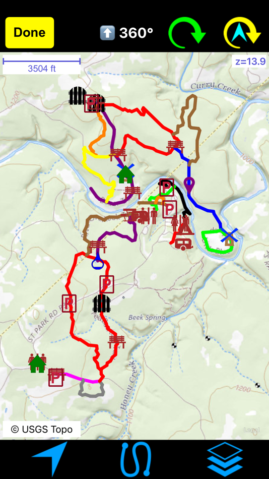
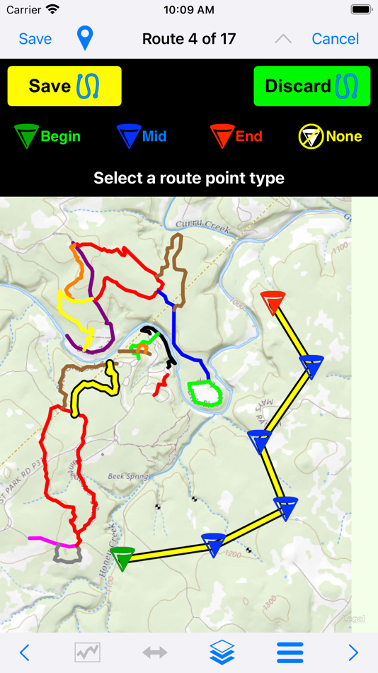
Create routes on maps in Hikers Assist+ (iPad recommended). Import routes via standard GPX files from the Internet. Or collect GPS tracks while on the trail and then convert them to routes for you or your friends.
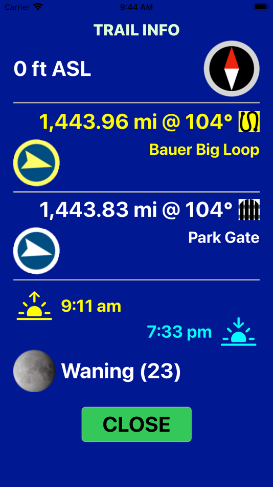
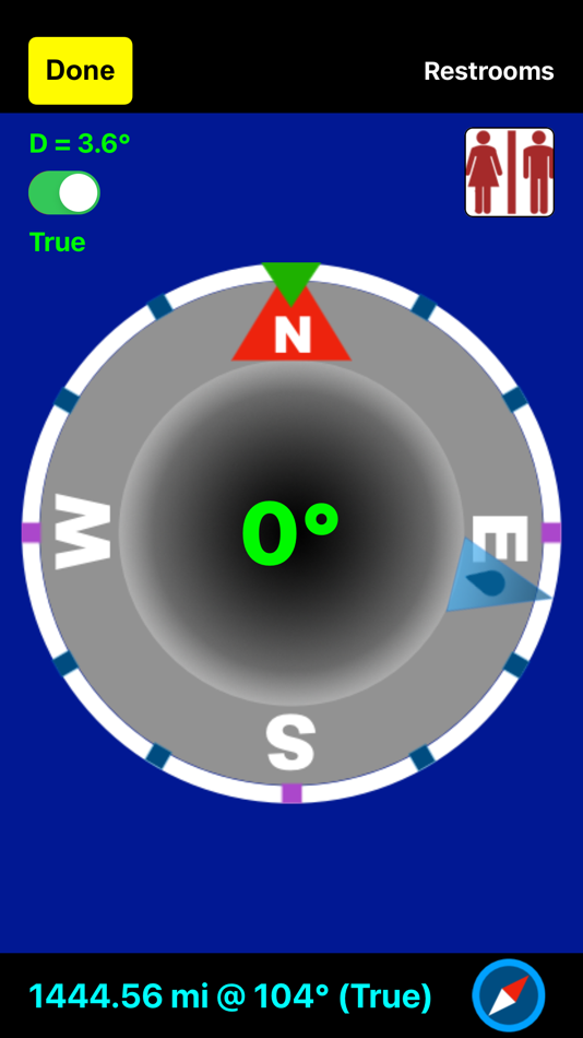
If you’ve loaded tracks, routes, and/or waypoints (we call that trail data), you can get the distance/bearing to the nearest point on the trail at any time or the distance/bearing to any of your waypoints.
If you are confused by intersecting trails, you can put the map into user tracking mode and orient your iPhone along either trail to determine your correct route.
Maps can be downloaded for offline use on trails without cellular access from USGS and other Internet open source map servers. We do not provide our own map servers. Thus all downloaded maps are free of charge.
The app is designed for optimum performance and ease-of-use as a combined phone/watch pair, although the iPhone app alone provides full functionality.
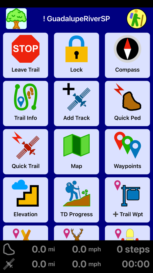
Quick trail (GPS tracking), quick pedometer, and ‘as needed’ modes on both the iPhone and watch let you record tracks and records of your hikes with whatever level of power usage you desire.
Tracks being recorded are instantaneously available on your maps. You will never get lost (even if you get off your trail), and you can always find your way back to the trailhead.
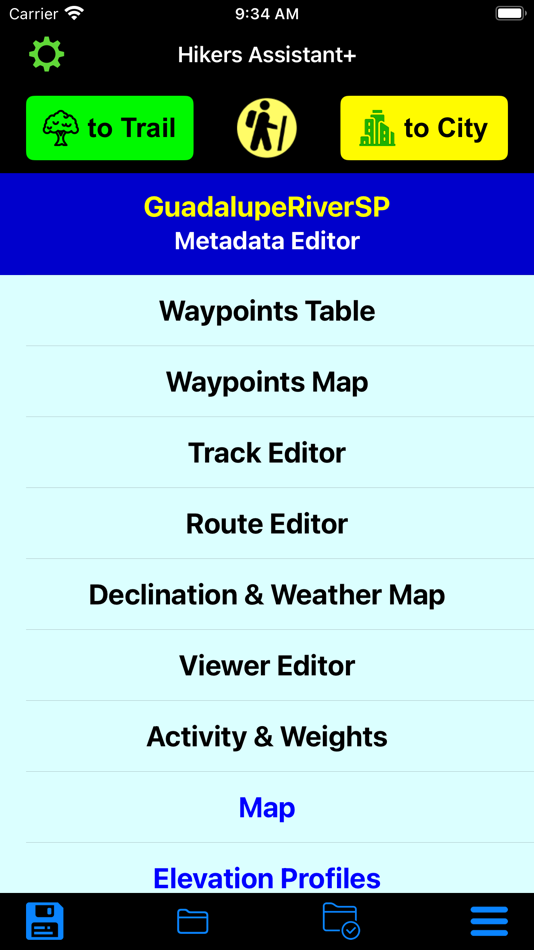
Dual off-trail (route planning and analysis) and on-trail home pages optimize the process of trek planning, creating routes, and safely executing the hike!
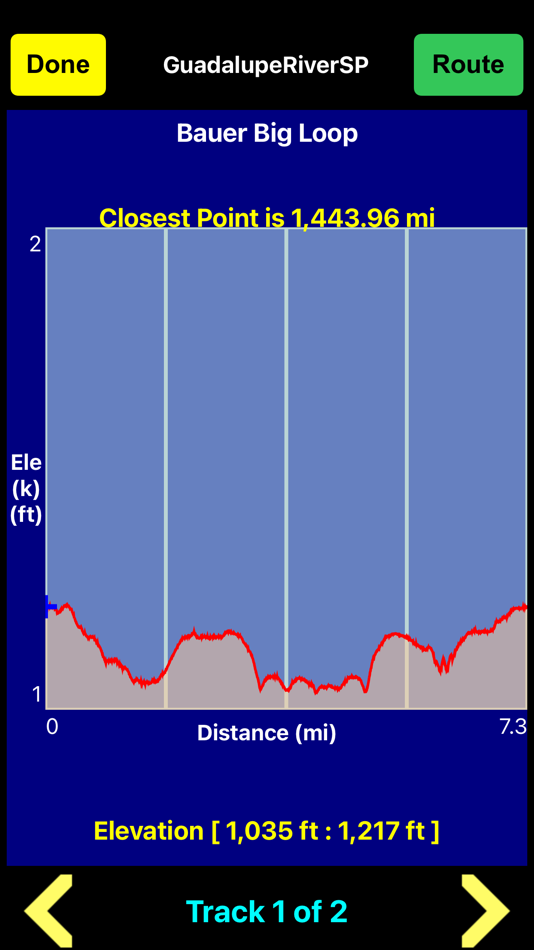
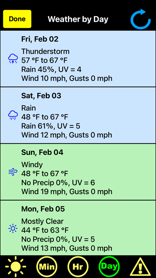
The on-trail home page uses large, easily seen buttons to execute modules that include GPS tracking, pedometer logging, maps, elevation profiles, distances and bearings to waypoints, creating new waypoints, a compass, getting elevation, sunrise/sunset/moon-phase, weather forecasts, and viewing park maps.
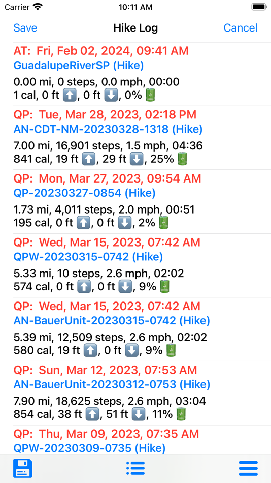
Off-trail, pre-hike planning provides you track, route and waypoint editors, maps where you can create routes, elevation profiles, and an extensive help system. Post trail, you can analyze your performance via hike and daily motion logs that show time on trail, speed, distance, steps, floors-up/down, calories burned, and battery used.
Trail data (tracks, routes, waypoints) can be saved in binary format both locally on the device or in iCloud. You can import park maps in PNG, JPG or PDF formats. You can share or import GPS trail data in standard GPX files. If you have trail files from the old Hikers Assistant, you can simply import those via iOS sharing.
The watch app allows you to monitor your iPhone’s GPS tracking progress, create its own quick GPS trail, log its own quick pedometer-based hike, or just use trail data as needed to find the nearest point on the trail or the distance/bearing to nearby waypoints. You can also monitor your hike, run, cycle, or paddle as a workout. In most situations, you can leave your iPhone in your pocket or pack.
The synergy between iPhone and watch apps let you choose the best solution in terms of power usage and convenience to meet all your hiking needs.
OTHER IMPORTANT INFORMATION
For on-trail use, your iOS device needs cellular/GPS capability. Trip planning can be completed on a WiFi-only device, with trail files emailed or transferred via iCloud to your on-trail device.
Offline map downloads rely primarily on USGS servers. Some offline maps support only US regions.
CAUTION: USGS occasionally changes their map server URL's and configurations. This may prevent some offline downloads until the next app update.
Continued use of GPS running in the background can dramatically decrease battery life.
Ảnh chụp màn hình

Giá bán
- Hôm nay: Miễn phí
- Tối thiểu: Miễn phí
- Tối đa: Miễn phí
Theo dõi giá
Nhà phát triển
- SGB Services, LLC
- Nền tảng: iOS Ứng dụng (2)
- Danh sách: 0 + 0
- Điểm: 0 + 0 ¡
- Xếp hạng: 0
- Đánh giá: 0
- Giảm giá: 0
- Video: 0
- RSS: Đăng ký
Điểm
0 ☹️
Xếp hạng
0 ☹️
Danh sách
0 ☹️
Đánh giá
Hãy là người đầu tiên đánh giá 🌟
Thông tin bổ sung
- Phiên bản: 2.1.7
- ID: com.sgb-services.HikersAssistantPlus
- Danh mục:
iOS Ứng dụng›Bản đồ và dẫn đường - HĐH:
Apple Watch,iPad,iPhone,iOS 15.0 trở lên - Kích thước:
17 Mb - Ngôn ngữ được hỗ trợ:
English - Xếp hạng nội dung:
4+ - App Store Xêp hạng:
0 - Cập nhật:
- Ngày phát hành:
Bạn cũng có thể thích
-
- Find My Car Plus
- iOS Ứng dụng: Bản đồ và dẫn đường Bởi: Victor Ruiz Rosell
- Miễn phí
- Danh sách: 0 + 0 Xếp hạng: 0 Đánh giá: 0
- Điểm: 0 + 0 Phiên bản: 1.0.3 Find My Car Plus Save your car s location in one tap using the app or widgets. Customize your car, store multiple locations, and access them anytime. Simple, fast, and always ready ... ⥯
-
- AV Assistant
- iOS Ứng dụng: Bản đồ và dẫn đường Bởi: Clint O'Connor
- Miễn phí
- Danh sách: 0 + 0 Xếp hạng: 0 Đánh giá: 0
- Điểm: 0 + 4 (5.0) Phiên bản: 2.7.6 AV Assistant is an informational aid for U.S. waters that shows your location and details on all surrounding aids to navigation (buoys, lights, etc) within your Area of Interest. The ... ⥯
-
- AoA Flight Assistant
- iOS Ứng dụng: Bản đồ và dẫn đường Bởi: Davor Pleskina
- $19.99
- Danh sách: 0 + 0 Xếp hạng: 0 Đánh giá: 0
- Điểm: 0 + 0 Phiên bản: 1.3 Use your mobile phone or tablet as Angle of Attack indication/warning instrument. If you are a pilot and your airplane lacks an instrument which shows you airplane's Angle of Attack, ... ⥯
-
- Al Thuraya Plus
- iOS Ứng dụng: Bản đồ và dẫn đường Bởi: Najoom Al Thuraya Security Control Services L.L.C
- Miễn phí
- Danh sách: 0 + 0 Xếp hạng: 0 Đánh giá: 0
- Điểm: 0 + 0 Phiên bản: 2.2.1 Al Thuraya Plus provides the best tracking devices and software solutions that enable customers to improve productivity by enabling the effective management of a fleet of cars all over ⥯
-
- Map Plus
- iOS Ứng dụng: Bản đồ và dẫn đường Bởi: Miocool Inc.
- Miễn phí
- Danh sách: 1 + 1 Xếp hạng: 0 Đánh giá: 0
- Điểm: 0 + 613 (4.6) Phiên bản: 2.9.0 The most powerful and versatile tool for viewing and editing custom maps, surveying, editing or managing mass of your geography data. You can use Map Plus as a professional GIS tool ... ⥯
-
- Seeing Assistant AlarmGPS
- iOS Ứng dụng: Bản đồ và dẫn đường Bởi: Transition Technologies S.A.
- Miễn phí
- Danh sách: 0 + 0 Xếp hạng: 0 Đánh giá: 0
- Điểm: 0 + 0 Phiên bản: 1.2.6 Seeing Assistant AlarmGPS is an application developed by Transition Technologies S.A. in order to support blind and low vision people in everyday life. Application provides advanced ... ⥯
-
- Anchor Plus
- iOS Ứng dụng: Bản đồ và dẫn đường Bởi: Roy Cadman
- $1.99
- Danh sách: 0 + 0 Xếp hạng: 0 Đánh giá: 0
- Điểm: 0 + 7 (4.7) Phiên bản: 1.4.13 More than just an anchor alarm. Enjoy these great features: - Use Siri Shortcuts and voice commands to set the anchor alarm - Set the alarm during anchoring (current position) or ... ⥯
-
- GDA Personal Assistant
- iOS Ứng dụng: Bản đồ và dẫn đường Bởi: GOZEN TEKNOLOJI VE BILISIM ANONIM SIRKETI
- Miễn phí
- Danh sách: 0 + 0 Xếp hạng: 0 Đánh giá: 0
- Điểm: 0 + 4 (5.0) Phiên bản: 3.5.4 GDA Personal Assistant automatically receives crew briefing information and presents it to you in a very intuitive way. Personal Assistant allows you quick access to vital information ... ⥯
-
- COTA Plus
- iOS Ứng dụng: Bản đồ và dẫn đường Bởi: Via Transportation, Inc.
- Miễn phí
- Danh sách: 0 + 0 Xếp hạng: 0 Đánh giá: 0
- Điểm: 0 + 499 (4.7) Phiên bản: 4.22.2 COTA Plus is a first of its kind service, which integrates technology with a transportation solution to provide customers with further access to jobs, healthcare and more. Just ... ⥯
-
- Cachetur.no Trip Assistant
- iOS Ứng dụng: Bản đồ và dẫn đường Bởi: Cachetur.no
- Miễn phí
- Danh sách: 0 + 0 Xếp hạng: 0 Đánh giá: 0
- Điểm: 0 + 8 (4.5) Phiên bản: 2.3.0 The cachetur.no Trip Assistant app helps you keep track of your cachetur.no trip plan while out geocaching. You can also easily update the ETA calculation to match your actual ... ⥯
-
- Traxsmart Plus
- iOS Ứng dụng: Bản đồ và dẫn đường Bởi: VENERA SOFTWARE PRIVATE LIMITED
- Miễn phí
- Danh sách: 0 + 0 Xếp hạng: 0 Đánh giá: 0
- Điểm: 0 + 0 Phiên bản: 1.0 Traxsmart Plus is the best vehicle tracking application which can help you to track your vehicle like a car, bike, bus etc. It also provides facility to keep track of your route while ... ⥯
-
- Garage Plus Recovery
- iOS Ứng dụng: Bản đồ và dẫn đường Bởi: Business Building
- Miễn phí
- Danh sách: 0 + 0 Xếp hạng: 0 Đánh giá: 0
- Điểm: 0 + 0 Phiên bản: 2.9 Garage Plus provides you with integrated services for the maintenance of all car malfunctions, from the simplest to the most complex, whether internal damage to the machine and ... ⥯
-
- CONNECT PLUS GPS
- iOS Ứng dụng: Bản đồ và dẫn đường Bởi: Bindu Bala
- Miễn phí
- Danh sách: 0 + 0 Xếp hạng: 0 Đánh giá: 0
- Điểm: 0 + 0 Phiên bản: 1.0 CONNECT PLUS GPS is the best vehicle tracking application which can help you to track your vehicle like a car, bike, bus etc. It also provides facility to keep track of your route ... ⥯
-
- GPS Tracker Plus
- iOS Ứng dụng: Bản đồ và dẫn đường Bởi: Mark Davies
- Miễn phí
- Danh sách: 0 + 0 Xếp hạng: 0 Đánh giá: 0
- Điểm: 0 + 0 Phiên bản: 7.1 An app that turns your mobile device into a real time tracking device. This app uses your sensors to log telemetry and position data for your mobile device. This data is then sent to ... ⥯