| デベロッパー: | Cato Technologies LLC (5) | ||
| 価格: | $9.99 | ||
| ランキング: | 0 | ||
| レビュー: | 0 レビューを書く | ||
| リスト: | 0 + 0 | ||
| ポイント: | 0 + 496 ¡ | ||
| ポイント + 1 | |||
説明
Hot Air is a flight logging and tracking application made especially for hot air balloon pilots! It's like having a log book and data recorder in your pocket! Hot air is loaded with lots of different features; many based on pilot feedback from around the world.
---------------------------
Major Features:
---------------------------
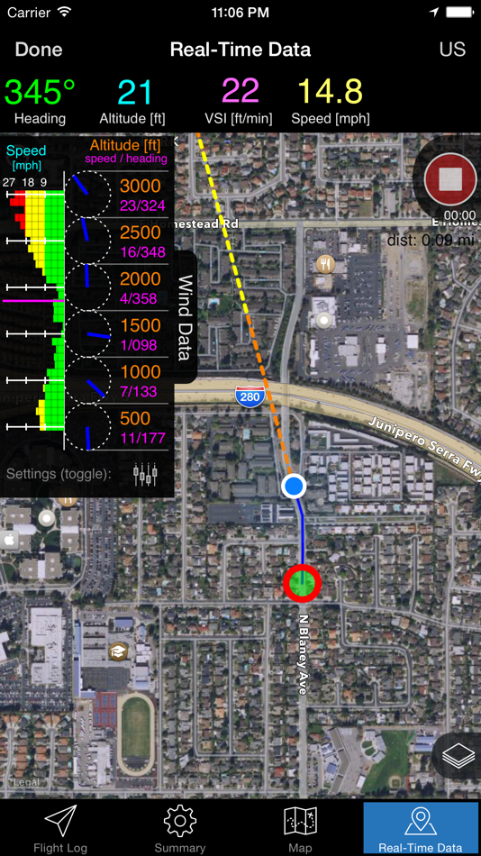
- Real-time tracking! Great for improving situationally awareness, see your current location on a map or satellite imagery
- Waypoints to show your distance, bearing, and ETE to a target location
- Offline maps available
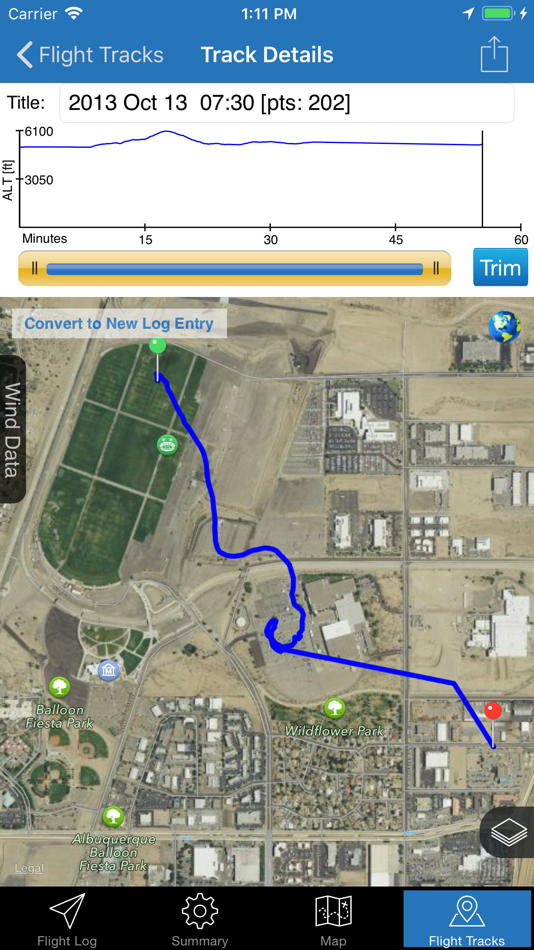
- Record your entire flight path (you can even turn your screen off during recording)! Then you can export your flight to your computer and view it in 3D using Google Earth
- KML/KMZ overlays! Add custom overlay data to the real-time flight maps (can be used to map out electric lines, friendly or unfriendly places to land, denoting special airspaces, include information such as radio frequencies or phone numbers, etc.).
- Wind data tracking - records wind speed and direction at the various altitudes as you fly
- Integration of the Glympse location sharing service to allow ground crew, family, or others to track your flight in real-time. They can track you using almost any device with a data connection.
- Flight Log- the log makes it easy to track information common to all pilots such as crew members, passengers, maximum envelope temperature, and propane used. The log also makes saving takeoff and landing locations convenient, thanks to the iPhone’s GPS or triangulation capabilities; plus, it has a "favorites" list for takeoff locations. The log can also aid in flight planning and separates future flights from past flights using a simple color-coding scheme.
- Flight Data Summary: this tab quickly tallies flights and hours flown. The summary includes a total of all flights or just the ones made within the past 90 days. Plus a summary of the crew used for past flights.
- Summary Map: on the map tab, the logged flights that have a saved takeoff and landing location can be plotted and compared on an interactive map
- Data export: export your flight log in HTML, KML (for viewing in Google Earth), and GPX (GPS Exchange)
- Data backup and restore - to be certain your data is safe!
- Comprehensive payload calculator
- Measure Tool
- View weather conditions and forecasts from within the app
- Universal app - works on iPad (landscape and portrait) as well as the iPhone and iPod touch!
- Facebook integration - it is easy to post a quick summary of your latest flight to Facebook and even includes a link to a map!
- Real-time tracking heading projection-line option
---------------------------
This app includes translations in English, French, Czech, and Slovak!
---------------------------
Note: During real-time flight mode the GPS is continuously running in the background which can significantly decrease battery life.
スクリーンショット


新機能
- バージョン: 12.3.3
- アップデート:
- V12.3.3
- Resolved additional Glympse issues
- iOS 17 compatibility improvements
価格
- 今日: $9.99
- 最小値: $4.99
- 最大: $9.99
料金のチェック
デベロッパー
- Cato Technologies LLC
- プラットフォーム: Android アプリ (2) iOS アプリ (3)
- リスト: 0 + 0
- ポイント: 0 + 497 ¡
- ランキング: 0
- レビュー: 0
- 割引: 0
- 動画: 0
- RSS: 購読する
ポイント
見つかりませんでした ☹️
ランキング
見つかりませんでした ☹️
リスト
見つかりませんでした ☹️
レビュー
最初のクチコミを書こう!
情報
連絡先
- ウェブサイト:
 https://www.hotairapp.com
あなたも好きかも
-
- Air Navigation Pro
- iOS アプリ: ナビゲーション 作者: Xample Sarl
- * フリー
- リスト: 0 + 1 ランキング: 0 レビュー: 0
- ポイント: 2 + 550 バージョン: 8.3.370 Discover our flight planning & real-time navigation app for free for 28 days! - Everything you need to fly around the world - Plan your flight in a few minutes - Fly relaxed with ...
-
- FlyGo Air Navigation
- iOS アプリ: ナビゲーション 作者: Flygo-Aviation Ltd
- * フリー
- リスト: 0 + 0 ランキング: 0 レビュー: 0
- ポイント: 0 + 51 バージョン: 2.18 FlyGo Air Navigation is designed to make flights safer and navigation easier. It provides advanced yet easy-to-use aviation tools for all kinds of pilots, such as route planning, ...
-
- NAVAIR Building Locator
- iOS アプリ: ナビゲーション 作者: Naval Air Systems Command
- フリー
- リスト: 0 + 0 ランキング: 0 レビュー: 0
- ポイント: 0 + 39 バージョン: 3.2.1 NAVAIR Building Locator is the go to mobile application in order to find where you need to go on any NAVAIR base. This application allows you to search any building number and gives ...
-
- Pilot: Aviation Altimeter
- iOS アプリ: ナビゲーション 作者: Daniel Schuler
- フリー
- リスト: 0 + 0 ランキング: 0 レビュー: 0
- ポイント: 0 + 115 バージョン: 1.2.0 "Used this app last weekend. Was within +/-40 feet of my Garmin for the 2.5 hours flight. (FAA standard: +/-75 feet)" Xploring Alaska, bush pilot. "Very Impressive. It was pretty much ...
-
- Density Altitude +
- iOS アプリ: ナビゲーション 作者: Rate Of Climb Industries
- $3.99
- リスト: 0 + 0 ランキング: 0 レビュー: 0
- ポイント: 0 + 838 バージョン: 2.7 Instant and location accurate Density Altitude calculator/instrument app for iPhone and iPad that also finds relative air density (RAD), altimeter setting, relative humidity, specific ...
-
- Satellite Finder (Pro)
- iOS アプリ: ナビゲーション 作者: Peter Bohl
- フリー
- リスト: 0 + 0 ランキング: 0 レビュー: 0
- ポイント: 0 + 4,388 バージョン: 2.68 The app helps you to align your satellite antenna. Based on your location and the selected satellite the app shows you in which horizontal and vertical direction you have to align your
-
- Aero App
- iOS アプリ: ナビゲーション 作者: National Geospatial-Intelligence Agency
- フリー
- リスト: 0 + 0 ランキング: 0 レビュー: 0
- ポイント: 1 + 37 バージョン: 1.2402.7840 The NGA Aeronautical Application (Aero App) is an Electronic Flight Bag (EFB) mobile application developed by and for the DOD and FAA flight crews. The Application provides flight ...
-
- GPS: Navigation & Live Traffic
- iOS アプリ: ナビゲーション 作者: Prominent IT Tech Solutions LLC
- フリー
- リスト: 0 + 0 ランキング: 0 レビュー: 0
- ポイント: 1 + 51 バージョン: 3.6 GPS maps & navigation is the new trendy navigation app with real-time maps, voice-guided navigation, nearby places, weather, and air quality features. It is the app to navigate faster ...
-
- Apollo Scooters
- iOS アプリ: ナビゲーション 作者: Apollo Imports Inc
- フリー
- リスト: 0 + 0 ランキング: 0 レビュー: 0
- ポイント: 0 + 256 バージョン: 3.8.1094 The Apollo App pairs with our new generation of smart electric scooters and allows riders to refine and customize their riding experience to their liking. Take full control of your ...
-
- KakaoMap - Korea No.1 Map
- iOS アプリ: ナビゲーション 作者: Kakao Corp.
- フリー
- リスト: 0 + 1 ランキング: 0 レビュー: 0
- ポイント: 0 + 3,949 バージョン: 5.17.3 KakaoMap will show you the fastest routes in Korea! With KakaoMap, you can find everything you want in a map app, from directions to hot restaurants and local attractions, and more! ...
-
- Holding Pattern Trainer
- iOS アプリ: ナビゲーション 作者: FLEMINGER MEDIA LLC
- $4.99
- リスト: 0 + 0 ランキング: 0 レビュー: 0
- ポイント: 0 + 94 バージョン: 1.3.0 Save time and money on your instrument flight training by mastering IFR holding pattern entries at the comfort of your own mobile device. Make IFR flight training easier! Is the ...
-
- NaviBridge
- iOS アプリ: ナビゲーション 作者: DENSO CORPORATION
- フリー
- リスト: 0 + 0 ランキング: 0 レビュー: 0
- ポイント: 0 + 73 バージョン: 6.60 Search destinations on your favorite apps and use NaviBridge to send it from your phone to your car Navigation Unit. 1. Search your destinations from compatible apps or by genre or ...
-
- Altimeter: Elevation, Compass
- iOS アプリ: ナビゲーション 作者: Furkan Ozoglu
- フリー
- リスト: 0 + 0 ランキング: 0 レビュー: 0
- ポイント: 0 + 934 バージョン: 2.0.3 While traveling with a vehicle (car, bicycle, etc.), while hiking or climbing, you can instantly discover your location and altitude, direction, geographic coordinate, address and ...
-
- GoDee - shuttle bus booking
- iOS アプリ: ナビゲーション 作者: Godee Pte Ltd
- フリー
- リスト: 0 + 0 ランキング: 0 レビュー: 0
- ポイント: 0 + 15 バージョン: 1.35.5 Godee helps citizens and visitors of big cities travel more convenient, safer and cheaper way. Shuttle buses ride along the express routes linking the major districts and popular ...