| ผู้พัฒนา: | Navtech Software (38) | ||
| ราคา: | * ฟรี | ||
| การจัดอันดับ: | 0 | ||
| ความเห็น: | 0 เขียนความเห็น | ||
| รายการ: | 0 + 0 | ||
| แต้มแล: | 0 + 0 ¡ | ||
| App Store | |||
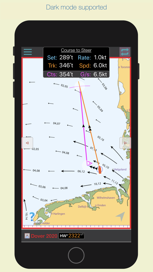
คำอธิบาย
")
The nearest Dover HW time to the actual time is selected from the database and the relevant streams chart is displayed, together with the time period for which the chart is valid.
As the time moves to the next valid period, the relevant hourly chart is auto displayed.
* Swiping on the chart (or using navigation buttons), displays the next or previous tidal hour chart.
* Whenever the chart displayed is valid at the current time, the validity period is displayed in green.
* Pinching the screen zooms the chart
* Tapping the location button shows your actual boat position on the chart.
* Select Local or UTC time.
Select the rate tool to auto calculate the interpolated tidal rate when in between neaps and springs.
Select the 'Set' tool to measure the precise true course of any tidal stream arrow. (in-app purchase)
Select the 'CTS' tool to calculate a Course to Steer. (in-app purchase)
The app automatically selects the nearest Dover HW time of the day, but if you want to see data for the next or previous HW of the day, swipe forward or back to advance the tidal hour.
For forward planning, tap on the date to select a different date, whereupon data relevant to that date will be displayed.
ภาพหน้าจอ


ราคา
-
* การซื้อภายในแอพ - วันนี้: ฟรี
- ต่ำสุด: ฟรี
- มากที่สุด: ฟรี
ติดตามราคา
ผู้พัฒนา
- Navtech Software
- แพลตฟอร์ม: Android แอป (16) iOS แอป (21) iOS เกม (1)
- รายการ: 0 + 0
- แต้มแล: 0 + 3 ¡
- การจัดอันดับ: 0
- ความเห็น: 0
- ลดราคา: 0
- วิดีโอ: 2
- RSS: ติดตาม
แต้มแล
0 ☹️
การจัดอันดับ
0 ☹️
รายการ
0 ☹️
ความเห็น
แสดงรีวิวเป็นคนแรกเลย 🌟
ข้อมูลเพิ่มเติม
รายชื่อติดต่อ
- เว็บไซท์:
 http://www.navsoft.co.uk
- 🌟 แชร์
- App Store
คุณอาจชอบ
-
- SEA.AI
- iOS แอป: การนำทาง โดย: SEA.AI SAS
- ฟรี
- รายการ: 0 + 0 การจัดอันดับ: 0 ความเห็น: 0
- แต้มแล: 0 + 0 เวอร์ชัน: 2.3 Increase your vigilance and improve your safety at sea with the SEA.AI application, the user interface of the first marine optical system based on artificial vision. SEA.AI increases ... ⥯
-
- iStreams North Sea (NW)
- iOS แอป: การนำทาง โดย: Navtech Software
- * ฟรี
- รายการ: 0 + 0 การจัดอันดับ: 0 ความเห็น: 0
- แต้มแล: 0 + 0 เวอร์ชัน: 2.96 iStreams displays the valid hourly North Sea (NW) tidal stream atlas for the current real time, in reference to the time of high water at Dover... a smart app, fully functional ... ⥯
- ใหม่
- Sea Maps
- iOS แอป: การนำทาง โดย: APP ASPIRES
- * ฟรี
- รายการ: 0 + 0 การจัดอันดับ: 0 ความเห็น: 0
- แต้มแล: 1 + 0 เวอร์ชัน: 1.03 Sea Maps is a marine navigation and weather app designed for boaters, anglers, and ocean explorers. Enjoy a free trial, then continue with a paid subscription to access all core ... ⥯
-
- North Carolina Traffic Cameras
- iOS แอป: การนำทาง โดย: LW Brands, LLC
- $2.99
- รายการ: 0 + 0 การจัดอันดับ: 0 ความเห็น: 0
- แต้มแล: 0 + 184 (4.5) เวอร์ชัน: 1.0 The best way to view North Carolina 511 traffic cameras. MAIN FEATURES INCLUDE: - Create custom camera groups - Quickly view all cameras on your route - Add camera widgets to your home ⥯
-
- North East Traveler
- iOS แอป: การนำทาง โดย: John Stump
- ฟรี
- รายการ: 0 + 0 การจัดอันดับ: 0 ความเห็น: 0
- แต้มแล: 0 + 5 (5.0) เวอร์ชัน: 1.1 Know before you go. Whether you're a commuter or a recreational traveler, you need information about the road ahead. With this app, you can see road conditions, view traffic cameras, ... ⥯
-
- Sea Pro Connect
- iOS แอป: การนำทาง โดย: John Crawford
- ฟรี
- รายการ: 0 + 0 การจัดอันดับ: 0 ความเห็น: 0
- แต้มแล: 0 + 0 เวอร์ชัน: 2.0.5 SeaPro GPS tracker allows clients to remotely monitor vital information on their boat and GPS track both in real time and also with historical playback ⥯
-
- Snowmobile North Dakota
- iOS แอป: การนำทาง โดย: MapGears inc.
- * ฟรี
- รายการ: 0 + 0 การจัดอันดับ: 0 ความเห็น: 0
- แต้มแล: 0 + 7 (4.9) เวอร์ชัน: 3.0.8 Out exploring on your snowmobile? Take your own mobile trail assistant for the ride! **NEW THIS SEASON** Track your trips: leave breadcrumbs for easier backtracking, get statistics on ... ⥯
-
- Open Sea OpenSeaMap Browser
- iOS แอป: การนำทาง โดย: Mobile Geographics
- ฟรี
- รายการ: 0 + 0 การจัดอันดับ: 0 ความเห็น: 0
- แต้มแล: 0 + 5 (3.2) เวอร์ชัน: 1.1 Open Sea is a browser for the maps produced by the OpenSeaMap project. OpenSeaMap is a subproject of OpenStreetMap, and generates freely usable nautical chart data and map image ... ⥯
-
- Find North
- iOS แอป: การนำทาง โดย: Carter Anderson
- ฟรี
- รายการ: 0 + 0 การจัดอันดับ: 0 ความเห็น: 0
- แต้มแล: 0 + 6 (5.0) เวอร์ชัน: 1.6 Find North is an engaging daily challenge designed exclusively for Apple Watch. Test your sense of direction by facing north each day and track your streaks as you improve. Leveraging ... ⥯
-
- Seasy - Making Sea Life Easy
- iOS แอป: การนำทาง โดย: Seasy GmbH
- ฟรี
- รายการ: 0 + 0 การจัดอันดับ: 0 ความเห็น: 0
- แต้มแล: 1 + 9 (4.9) เวอร์ชัน: 1.4.5 With Seasy, you can book marinas in Croatia, Italy, Greece, Spain, Turkey, France, Portugal, Slovenia, Montenegro, and more from the comfort of your yacht, without any additional ... ⥯
-
- MapApp NZ North Island
- iOS แอป: การนำทาง โดย: Dave Robertson
- $11.99
- รายการ: 0 + 0 การจัดอันดับ: 0 ความเห็น: 0
- แต้มแล: 0 + 1 (5.0) เวอร์ชัน: 3.0 MapApp NZ North Island displays full topographic maps of New Zealand's North Island. Explore the North Island on your iPhone or iPad. Find your current location on the map using the ... ⥯
-
- Mapitare Terrain and Sea map
- iOS แอป: การนำทาง โดย: Mapitare Oy
- * ฟรี
- รายการ: 0 + 0 การจัดอันดับ: 0 ความเห็น: 0
- แต้มแล: 0 + 0 เวอร์ชัน: 1.2.36 Now you can try all the maps free for seven days (except Swedish nautical charts for three days)! Mapitare is the first offline mapping software on the market that can be downloaded at ⥯
-
- LZ North
- iOS แอป: การนำทาง โดย: Luftambulansetjenesten HF
- * ฟรี
- รายการ: 0 + 0 การจัดอันดับ: 0 ความเห็น: 0
- แต้มแล: 0 + 0 เวอร์ชัน: 2.7.0 This Application is made by the National Air Ambulance Services of Norway for operators and partners in order to find and maintain Landing Zone information while operating off base. ... ⥯
-
- FP5000 NORTH AMERICA PRO
- iOS แอป: การนำทาง โดย: Rob Slater
- * $37.99
- รายการ: 0 + 0 การจัดอันดับ: 0 ความเห็น: 0
- แต้มแล: 0 + 0 เวอร์ชัน: 4.18.0 Flight Planner 5000 is our premium flight planning product for North America where comprehensive and accurate flight planning is required. It is used extensively by private pilots thru ⥯