| 開發人員: | JOMO Solutions Ltd (17) | ||
| 價錢: | 免費 | ||
| 排名: | 0 | ||
| 評測: | 0 寫評論 | ||
| 清單: | 0 + 0 | ||
| 點數: | 0 + 4 (3.3) ¡ | ||
| App Store | |||
描述
")
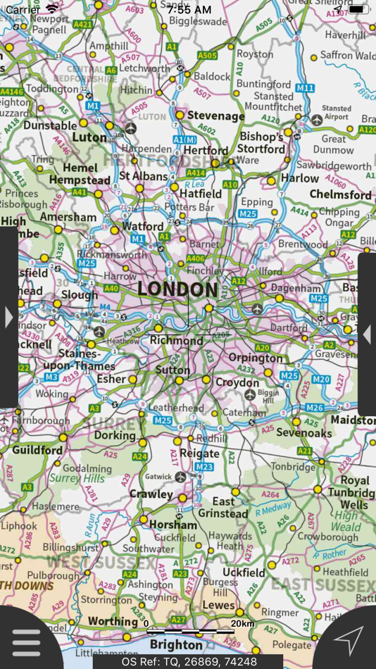
Beautifully detailed maps supplied by Ordnance Survey.
London Maps Offline provides a useful offline mapping reference and navigation aid whilst travelling throughout London by roadside, road, rail, canal, lake and river. A powerful offline search facility can locate places, roads, post codes and hills within the region. It also provides worldwide online Apple maps (Standard, Satellite and Hybrid). Map features that you are used to with Apple maps are available on both offline and online maps as well as providing 3D buildings on Apple maps (where available).
Maps
- 7 different levels of offline 2014/2015 Ordnance Survey map detail from national overview to street view within the region. (No data connection required)
Progressively more detailed maps are automatically loaded as the map view is zoomed. The maps seamlessly transition from one level of detail to the next. The OS recommended viewing scales for the more detailed maps are approximately as follows:
1:1000,000 (Whole of GB)
1:250,000
1:50,000
1:25,000
1:10,000 (Roads/streets are labelled)
The map region of the more detailed maps covers a rectangular region around the M25 orbital motorway (ref. http://jomosolutions.com/Maps)
London Underground stations, hospitals, airports and other features are marked on some of the more detailed maps.
App
- Offline search functionality with searchable locations (places, roads, post codes and hills). (For the place search a location's latitude and longitude is accurate to 0.1 of a minute of the centre point of the 1x1 km National Grid square in which the name falls)
- Detailed hill information, including height, OS Grid Ref, latitude and longitude, region, parent, classification, drop and hill specific links to Streetmap, Geograph and Hill Bagging web sites
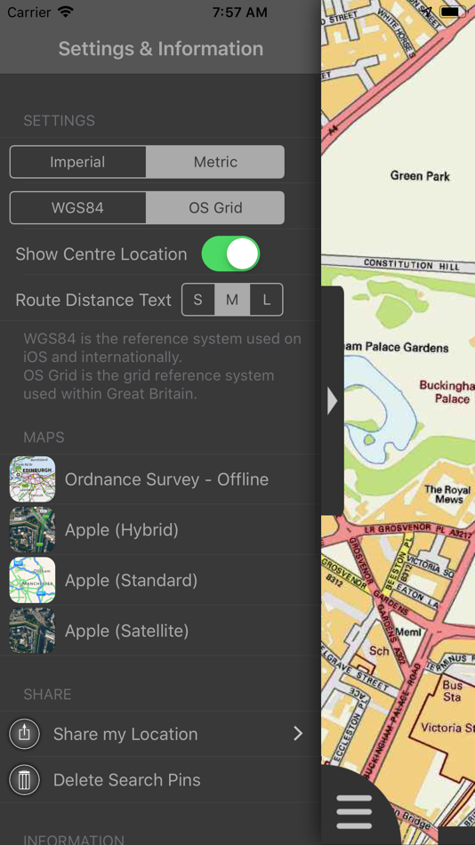
- Display of current GPS position as OS Grid Reference or WGS84 latitude and longitude
- "Share My Location" allowing users to share an image of their current location and location references. Buttons are provided to share location information by Facebook, Twitter, iMessage/SMS and e-mail
- Online access to worldwide Apple Standard, Satellite and Hybrid maps
- Apple 3D Buildings are displayed on Apple Standard maps
- Apple maps contain Points of Interest
- User location can be tracked with or without heading on all online and offline maps (GPS capable devices only)
- Display of scale bar in either metric or imperial units
- Display of current speed
- Zoom, pan, rotation of all maps
- Pitch of Apple Standard and Ordnance Survey maps
- Selection of current location annotation for display of speed and location data
- User setting for speed display in Miles per Hour (mph) or Kilometres per Hour (kph)
- Selection of search result pin annotations to display location information
- Collective deletion of search result annotation pins
- A user guide is provided within
The OS search data was published by Ordnance Survey in 2014.
Extracts from "The Database of British and Irish Hills" v14 published 22/04/2014 (ref. http://www.hills-database.co.uk/index.html )
No warranty
The data is supplied by Apple, Ordnance Survey and Database of British and Irish Hills.
The Information is licensed 'as is' and the Information Provider and/or Licensor excludes all representations, warranties, obligations and liabilities in relation to the Information to the maximum extent permitted by law.
The Information Provider and/or Licensor are not liable for any errors or omissions in the Information and shall not be liable for any loss, injury or damage of any kind caused by its use.
This app is not a substitute for a paper map and compass.
螢幕擷取畫面


新功能
- 版本: 2.0.0
- 發佈日期:
- User Interface improved. Support to Route/Waypoint added. Support for larger displays added. User Guide added.
If you like the app, please leave a review rating and comment on the App Store.
價錢
- 今天: 免費
- 最小值: 免費
- 最大值: 免費
追蹤票價
開發人員
- JOMO Solutions Ltd
- 平台: iOS 應用程式 (17)
- 清單: 1 + 1
- 點數: 0 + 16 ¡
- 排名: 0
- 評測: 0
- 折扣: 0
- 影片: 0
- RSS: 訂閱
點數
0 ☹️
排名
0 ☹️
清單
0 ☹️
評測
成為第一個評論 🌟
其他資訊
- 版本: 2.0.0
- 類別 :
iOS 應用程式›地圖與導航 - OS:
Apple Watch,iPad,iPhone,iOS 8.0 以上版本 - 大小:
510 Mb - 支援的語言 :
English - 內容分級:
4+ - App Store 評分:
3.3(4) - 發佈日期:
- 發行日期:
聯絡人
- 🌟 分享
- App Store
你可能還喜歡
-
- Organic Maps: Offline Map
- iOS 應用程式: 地圖與導航 由: Organic Maps
- 免費
- 清單: 1 + 1 排名: 0 評測: 0
- 點數: 3 + 995 (4.8) 版本: 2025.11.26 Organic Maps is a fast, detailed offline map and GPS navigation app for travel, hikes, and rides. Plan, import, and record routes, and enjoy smooth guidance without draining your ... ⥯
-
- Avenza Maps: Offline Mapping
- iOS 應用程式: 地圖與導航 由: Avenza Systems Inc.
- 免費
- 清單: 0 + 1 排名: 0 評測: 0
- 點數: 0 + 122,972 (4.8) 版本: 262 Avenza Maps, #1 app for hiking, biking and all trails. Featuring maps from National Geographic, national parks and more! On your next adventure, stay on track with GPS using offline ... ⥯
-
- Offline: Maps and Directions
- iOS 應用程式: 地圖與導航 由: Vicente Garcia Cortes
- * 免費
- 清單: 0 + 0 排名: 0 評測: 0
- 點數: 0 + 0 版本: 9 Maps and Navigation without internet. Create maps and have them ready always, even without Internet connection. Description Maps Offline allows you to create maps that will work on ... ⥯
-
- London Transport: Live TFL
- iOS 應用程式: 地圖與導航 由: Transit Now ltd
- 免費
- 清單: 0 + 0 排名: 0 評測: 0
- 點數: 1 + 518 (4.8) 版本: 2025.5.6 London Transport Your Smarter Way Around the Capital Get real-time TfL bus, Tube, Overground, and Elizabeth line updates all in one simple, reliable app designed for London travellers. ⥯
-
- London Transit (LTC)
- iOS 應用程式: 地圖與導航 由: Logan Pytyl
- 免費
- 清單: 0 + 0 排名: 0 評測: 0
- 點數: 0 + 17 (4.6) 版本: 1.24.1 London Transit (LTC) helps you get around London, Ontario with ease by showing live bus stop times, route maps, and schedules. Whether you are commuting to work, heading to class at ... ⥯
-
- Offline GPS Converter
- iOS 應用程式: 地圖與導航 由: Artur Pahasian
- 免費
- 清單: 0 + 0 排名: 0 評測: 0
- 點數: 0 + 1 (3.0) 版本: 1.0 Offline GPS Converter helps you instantly convert geographic coordinates no internet needed. Whether you're a field worker, radio operator, or outdoor enthusiast, this app delivers ... ⥯
-
- Offline gps maps: Mapy.com
- iOS 應用程式: 地圖與導航 由: Seznam.cz a.s.
- * 免費
- 清單: 0 + 0 排名: 0 評測: 0
- 點數: 5 + 1,151 (4.8) 版本: 6.62.2 PLAN YOUR ROUTE - hiking and cycling trails - cross-country skiing and ski-alpine trails - unique travel tips feature plans a trip through the most interesting places in the area - ... ⥯
-
- London Travel Guide with Map
- iOS 應用程式: 地圖與導航 由: Jorge Herlein
- * 免費
- 清單: 0 + 0 排名: 0 評測: 0
- 點數: 0 + 92 (4.5) 版本: 3.0.49 SPECIAL FEATURES - AUGMENTED REALITY - STOP CARRYING BOOK GUIDES!!! - 100% OFFLINE TRAVEL GUIDE - OFFLINE METRO MAP - ZOOMABLE 100% REGIONAL OFFLINE MAPS - PICS GALLERY - GPS CAPABLE - ⥯
-
- maps.earth
- iOS 應用程式: 地圖與導航 由: Michael Kirk
- 免費
- 清單: 0 + 0 排名: 0 評測: 0
- 點數: 0 + 4 (3.5) 版本: 1.13 Explore the world and get low stress directions powered by OpenStreetMap. maps.earth is built on open source. We never show you ads or sell your data. We just want a nice map. ⥯
-
- London Moves: Bus Tube Rail
- iOS 應用程式: 地圖與導航 由: Wekele Ltd
- 免費
- 清單: 0 + 0 排名: 0 評測: 0
- 點數: 0 + 0 版本: 1.01 Your all-in-one transport app for London. Includes: - Underground (Tube) - Overground and National Rail - Buses - Trams - DLR and more Features: - Search for times and routes easily - ... ⥯
-
- Offline Maps, GPS, Speedometer
- iOS 應用程式: 地圖與導航 由: Vaibhavi Bhingradiya
- 免費
- 清單: 0 + 0 排名: 0 評測: 0
- 點數: 0 + 0 版本: 1.0 Smart Travel Navigator is your complete travel and navigation assistant, designed to enhance your road trips, daily commutes, and exploration experiences. With a range of advanced ... ⥯
-
- London Live Bus - Probus
- iOS 應用程式: 地圖與導航 由: Christian Alfarano
- 免費
- 清單: 0 + 0 排名: 0 評測: 0
- 點數: 0 + 0 版本: 2.6.1 This live bus tracker app helps you find your way around the city by using public transport. Probus London provides you up to date bus times and an handy journey planner with helpful ... ⥯
-
- Maps My Location
- iOS 應用程式: 地圖與導航 由: Rohit Bhayani
- 免費
- 清單: 0 + 0 排名: 0 評測: 0
- 點數: 0 + 1 (1.0) 版本: 1.0 A Map My Location app for iOS is a software application designed to assist You in navigating from one location to another using the Global Positioning System (GPS) technology. Key ... ⥯
-
- London Live Bus Times
- iOS 應用程式: 地圖與導航 由: AppEffectsUK
- 免費
- 清單: 0 + 0 排名: 0 評測: 0
- 點數: 0 + 1 (5.0) 版本: 1.0 London Bus Times, the most comprehensive public transport tracking app on iOS devices! We stream data in real time from the Transport For London (TFL) data API stream, meaning you ll ... ⥯