| 開發人員: | Mark Malone (5) | ||
| 價錢: | * 免費 | ||
| 排名: | 0 | ||
| 評測: | 0 寫評論 | ||
| 清單: | 0 + 0 | ||
| 點數: | 0 + 0 ¡ | ||
| App Store | |||
描述
")
Create your own instant offline maps.
Create geolocated maps from photos and pictures, either with your own photos of maps, or with maps imported from elsewhere.
Open geolocated KMZ map images created by Map Snapper or other programs. Just copy it to Map Snapper.
Import Controls (placemarks) from KMZ, KML and IOF XML files, as well as create your own.
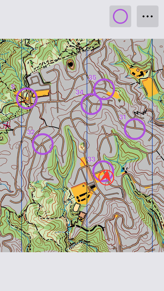
Check your control placement against the map, and satellite images. Fine tune the control locations while in the field.
Export your controls to KML files. Either export all controls, or create a MapRun compatible file with S1, numbered controls and F1 (if no F1, S1 location will be used for finish).
Export your controls to a Condes compatible file, then import to Condes to update the control locations.
Import Courses from IOF XML files, or create your own. These are simply a list of control codes in order and are used to create MapRun compatible KML files. Hubs are supported by repeating the control code for the hub for subsequent visits.
Map Snapper Pro (optional In-App Purchase)
With Map Snapper Pro, you can export your map with embedded location data as JPG or KMZ.
Map Snapper Pro also allows you to open multiple maps at once.
How to Geolocate a Map:
1. Take a photo of the map (or copy a picture to Map Snapper).
2. Choose an obvious location on your photo, and line up the purple crosshairs.
3. Find the same location on the map, and line up the purple crosshairs on the map.
4. Press the Purple crosshair button to lock this location.
5. Repeat for another location with the blue crosshairs.
6. Check your alignment, and use your map.
Note: Most maps on information boards are accurate enough for this simple alignment method to work - they just have to be drawn to scale.
How to work with Condes
https://condes.net (c) Finn Arildsen Software (not affiliated with Map Snapper):
1. From Condes, Export a KMZ or Bitmap Image as JPG.
2. Copy map (KMZ or JPG) to Map Snapper.
3. For JPG, geolocate the Map as described above.
4. Optional: export IOF XML Event Data with controls and send to Map Snapper.
5. Edit and add controls in Map Snapper as desired.
6. From Map Snapper, Export the Controls to Condes File.
7. Import the Controls into Condes, overwriting controls that have moved.
Note: Map Snapper defaults the Condes map location bottom left corner to (0,0).
In Condes, Either:
1. Make sure print area is at (0,0) - adjust the canvas map details East & North if not.
2. Or, for a geolocated map, export IOF XML Event Data with at least 2 Controls, send to Map Snapper, and update the map location.
螢幕擷取畫面

新功能
- 版本: 2.1
- 發佈日期:
- Lots of new updates designed to help with planning orienteering events.
Add support for:
Viewing and editing controls (placemarks/POIs) and courses.
Viewing map over satellite image to align controls more precisely.
Importing KMZ files with geolocated images and controls.
Importing KML files with controls.
Importing IOF XML files with controls and courses.
Exporting geolocated KMZ files.
Exporting KML files with controls (suitable for use with MapRun).
Export controls to Condes compatible file.
Note: Exporting KMZ files requires Map Snapper Pro.
價錢
-
* 應用內購買 - 今天: 免費
- 最小值: 免費
- 最大值: $0.99
追蹤票價
開發人員
- Mark Malone
- 平台: iOS 應用程式 (2) macOS 應用程式 (2) macOS 遊戲 (1)
- 清單: 0 + 0
- 點數: 0 + 1 ¡
- 排名: 0
- 評測: 0
- 折扣: 0
- 影片: 0
- RSS: 訂閱
點數
0 ☹️
排名
0 ☹️
清單
0 ☹️
評測
成為第一個評論 🌟
其他資訊
- 🌟 分享
- App Store
你可能還喜歡
-
- MineAR: Augmented Reality Map
- iOS 應用程式: 地圖與導航 由: Map Life, LLC
- * 免費
- 清單: 0 + 0 排名: 0 評測: 0
- 點數: 0 + 5 (5.0) 版本: 2.40.15 Data you can grasp. As a geoscience professional, we know you want an easier way to see your GIS data while you re in the field. MineAR allows you to do exactly that. Our app ... ⥯
-
- Map Switch: Convert Map Links!
- iOS 應用程式: 地圖與導航 由: Pavly Paules
- * 免費
- 清單: 0 + 0 排名: 0 評測: 0
- 點數: 9 + 2 (5.0) 版本: 2.6.1 Map Switch - Open map links in your favourite map service Transform your map experience with Map Switch, the ultimate tool for converting between Apple Maps, Google Maps, Waze, Bing ... ⥯
-
- Map LT
- iOS 應用程式: 地圖與導航 由: Taylan Atasoy
- 免費
- 清單: 0 + 0 排名: 0 評測: 0
- 點數: 0 + 0 版本: 4.0 Map LT is a cutting-edge navigation and mapping application designed for users who want to easily find their way around World. With its user-friendly interface and comprehensive ... ⥯
-
- Map Map - Your Map on a Map
- iOS 應用程式: 地圖與導航 由: Ben Roberts
- * 免費
- 清單: 0 + 0 排名: 0 評測: 0
- 點數: 0 + 2 (5.0) 版本: 2.3 Welcome to Map Map Your Personal Cartographer! Ever wished you could see where you were on a trail map, building diagram, or any other visual reference? How about knowing where a trail ⥯
-
- Memory-Map for All
- iOS 應用程式: 地圖與導航 由: Memory-Map
- 免費
- 清單: 0 + 0 排名: 0 評測: 0
- 點數: 0 + 9 (4.9) 版本: 2.0.5 Download maps for Offline GPS Navigation. No mobile data connection required. Your favorite maps and charts from OS, Hema, NOAA, and many more. Immersive 3D World map view Fully ... ⥯
-
- Map MateAI- Navigate with Chat
- iOS 應用程式: 地圖與導航 由: Ahmet Erkin Arıkan
- 免費
- 清單: 0 + 0 排名: 0 評測: 0
- 點數: 0 + 0 版本: 1.0.3 Struggling to decide where to go? Let our app guide you! Whether you're searching for a cozy café, an exciting spot to explore, or a pharmacy on duty, we ve got you covered. Simply ... ⥯
-
- Map Tells...!
- iOS 應用程式: 地圖與導航 由: Yuriko Kimura
- 免費
- 清單: 0 + 0 排名: 0 評測: 0
- 點數: 0 + 0 版本: 3.4 "Map Tells...! is an app that shares your location with your companion by providing a Google Maps link and photo. The mail receiver follows the directions (on the map or through a ... ⥯
-
- Map It Realtour
- iOS 應用程式: 地圖與導航 由: DKP Productions LLC
- 免費
- 清單: 0 + 0 排名: 0 評測: 0
- 點數: 0 + 3 (5.0) 版本: 2.0.2 Map It Realtour® / Mobile Application for Realtors With New Map It Client Version for Their Clients Map It Realtour® is a new and unique Real Estate App for Agents worldwide, that was ... ⥯
-
- Map Tools
- iOS 應用程式: 地圖與導航 由: Modular Machines LLC
- $1.99
- 清單: 0 + 0 排名: 0 評測: 0
- 點數: 0 + 1 (5.0) 版本: 6.1 Map Tools supports coordinate systems and map projections for 232 datums, including WGS84, NAD27, NAD83, ED50, OSGB36, EGSA87, AGD66, AGD84, GDA94, NZGD2000, NZGD1949, and many more. ... ⥯
-
- Map Points
- iOS 應用程式: 地圖與導航 由: Sachin Deshpande
- $0.99
- 清單: 0 + 0 排名: 0 評測: 0
- 點數: 0 + 0 版本: 1.2 Map Points is an app to store your favorite map locations. You can use it while hiking to mark pinpoint locations that you want to remember. Or you can drop a pin to mark the secret ... ⥯
-
- Map Link Converter
- iOS 應用程式: 地圖與導航 由: POORNA S JAYASINGHE
- $4.99
- 清單: 0 + 0 排名: 0 評測: 0
- 點數: 0 + 0 版本: 1.0 Seamlessly open any map link in your preferred navigation app. Map Link Converter is the ultimate tool for converting and opening map URLs across different mapping platforms. Whether ... ⥯
-
- Map Plus
- iOS 應用程式: 地圖與導航 由: Miocool Inc.
- 免費
- 清單: 1 + 1 排名: 0 評測: 0
- 點數: 0 + 615 (4.6) 版本: 2.9.0 The most powerful and versatile tool for viewing and editing custom maps, surveying, editing or managing mass of your geography data. You can use Map Plus as a professional GIS tool ... ⥯
-
- Map Paint
- iOS 應用程式: 地圖與導航 由: Kouichi INAFUKU
- $0.99
- 清單: 1 + 0 排名: 0 評測: 0
- 點數: 1 + 0 版本: 1.0.1 It is an application that you can paint on the map Note The position of the map may shift slightly when reloading the saved data The map when edited is slightly different from the ... ⥯
-
- Map Ruler - Distance Measure
- iOS 應用程式: 地圖與導航 由: Sergey Irgeshov
- 免費
- 清單: 0 + 0 排名: 0 評測: 0
- 點數: 0 + 13 (3.9) 版本: 2.0.1 Measure the distance traveled, plot your running route, calculate the area on the map, and much more! The application is convenient to use, as there is nothing superfluous in it, so ... ⥯