| 開發人員: | Nautical Solutions International, Inc. (1) | ||
| 價錢: | * $39.99 | ||
| 排名: | 0 | ||
| 評測: | 0 寫評論 | ||
| 清單: | 0 + 0 | ||
| 點數: | 2 + 7 (2.1) ¡ | ||
| App Store | |||
描述
")
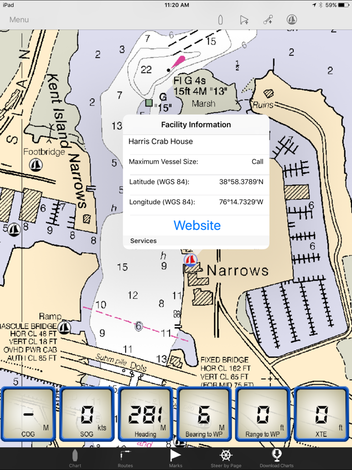
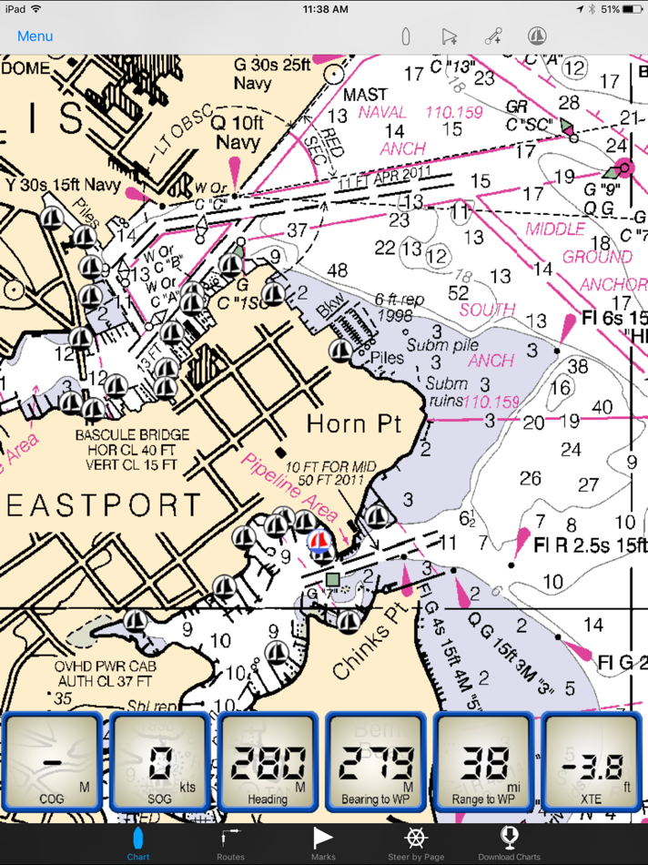
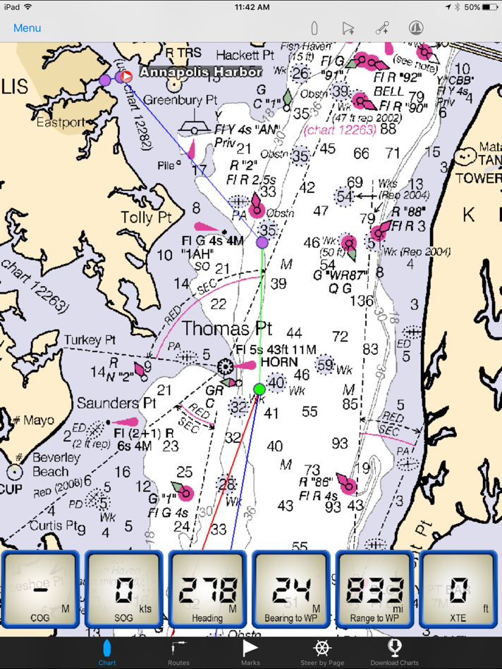
The Maptech iPlot app is simple to use chart plotter app that utilizes many of the same routing functions that Maptech uses in their digital software. The iPlot uses the same NOAA nautical charts you are familiar with from Maptech chart plotting programs such as Offshore Navigator, Chart Navigator Pro, Sea Ray Navigator and i3 Navigator. Plan routes, place marks, and easily zoom and scale charts with your fingers. The iPlot features a smooth and fast chart quilting engine that makes going from one chart to the other seamless. Once the app and charts are downloaded no data connection is required for operating the iPlot app.
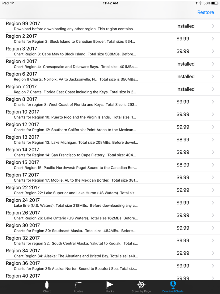
The Maptech iPlot App purchase includes all US small scale planning charts which can be downloaded from the Chart Download page within the app. To accurately navigate with the Maptech iPlot App you will need to purchase a region of charts for your area of interest. These chart regions can be download from within the app itself from the Chart Download page at an additional cost of $9.99 each. All charts are updated every January and neither the app or the charts require a subscription fee nor will they ever expire.
Features include:
Uses NOAA Raster Charts (RNCs)
Full US Chart Coverage available
Lightning fast chart quilting engine
Unlimited custom routes and marks creation
Index of all routes and marks
Place Mark at vessel function for MOB or an anchor alarm
Instant waypoint with a touch of the finger
Full route list of all waypoints showing instant DTW, BTW and ETA to each
Full mark list showing instant DTW, BTW and ETA to each
Reverse route function
Easy method for inputting your already created routes
Unique route steering by highway display page
Adjustable waypoint arrival time
Easy to read data windows for COG, SOG, HDG, BTW, RTW, XTE
Easy locate vessel button
Orientations include heads up, north up, look ahead
Choose bearings True or Magnetic
Import/Export from Offshore Navigator
Maptech facilities
WIFI AIS targets
Chart Regions:
Region 02 - Block Island, RI to the Canadian Border
Region 03 - New York to Nantucket and Cape May, NJ
Region 04 - Chesapeake and Delaware Bays
Region 06 - Norfolk, VA to Florida including the ICW
Region 07 - Florida East Coast and the Keys
Region 08 - Florida West Coast and the Keys
Region 10 - Puerto Rico and the U.S. Virgin Islands
Region 12 - Southern California: Point Arena to the Mexican Border
Region 13 - Lake Michigan
Region 14 - San Francisco to Cape Flattery
Region 15 - Pacific Northwest: Puget Sound to the Canadian Border
Region 17 - Mobile, AL to the Mexican Border
Region 22 - Lake Superior and Lake Huron (U.S. Waters)
Region 24 - Lake Erie (U.S. Waters)
Region 26 - Lake Ontario (U.S. Waters)
Region 30 - Southeast Alaska
Region 32 - South Central Alaska: Yakutat to Kodiak
Region 34 - Alaska: The Aleutians and Bristol Bay
Region 36 - Alaska: Norton Sound to Beaufort Sea
Region 40 - Hawaiian Islands and U.S. Territories
If your iPad was purchased with the ability to subscribe to a data plan from your provider, it already has a built in GPS and does not require a Wi-Fi or external GPS to navigate with the iPlot app. You can tell this easily by looking at the top display bar to see if you have the indicator bars for cell strength, if you do then you have a GPS built in. If not, your iPad does not have a built in GPS and you will need to turn on location services and Wi-Fi capability to receive your location to navigate with the iPlot app. However, if you plan on using this outside of urban areas where there is no location services network, you will lose the ability to track your position. It is highly recommended that if you plan on using the Maptech iPlot for real time navigation and your unit is one without a GPS that you use it with an external plug in or bluetooth GPS. We recommend the Bad Elf GPSs. We also recommend Snow Lizard Products iPad cases which have optional Bad Elf GPS receivers built in.
螢幕擷取畫面

價錢
-
* 應用內購買 - 今天: $39.99
- 最小值: $39.99
- 最大值: $39.99
追蹤票價
開發人員
- Nautical Solutions International, Inc.
- 平台: iOS 應用程式 (1)
- 清單: 0 + 0
- 點數: 2 + 7 ¡
- 排名: 0
- 評測: 0
- 折扣: 0
- 影片: 0
- RSS: 訂閱
點數
-

- 4,752 Chuchi Flores
- +1
-
- 1,855 its me jean vargas
- +1


排名
0 ☹️
清單
0 ☹️
評測
成為第一個評論 🌟
其他資訊
- 🌟 分享
- App Store
你可能還喜歡
-
- Google Maps
- iOS 應用程式: 地圖與導航 由: Google
- 免費
- 清單: 14 + 9 排名: 5 (3) 評測: 5 (1)
- 點數: 5 + 6,970,577 (4.7) 版本: 25.47.0 Explore and navigate the world with confidence using Google Maps. Find the best routes with live traffic data and real-time GPS navigation for driving, walking, cycling, and public ... ⥯
-
- Waze Navigation & Live Traffic
- iOS 應用程式: 地圖與導航 由: Waze Inc.
- 免費
- 清單: 9 + 4 排名: 5 (1) 評測: 0
- 點數: 1 + 3,108,496 (4.8) 版本: 5.13.0.2 Know what's ahead on the road with the help from other drivers. Waze is a live map that harnesses the local knowledge of tens of millions of drivers around the world. Drivers safely ... ⥯
-
- Transit • Subway & Bus Times
- iOS 應用程式: 地圖與導航 由: Transit App, Inc.
- 免費
- 清單: 3 + 0 排名: 0 評測: 0
- 點數: 0 + 845,312 (4.6) 版本: 6.0.10 Transit is your real-time urban travel companion. Open the app to instantly see accurate next departure times, track buses and trains near you on the map, and see upcoming transit ... ⥯
-
- SpotHero: #1 Rated Parking App
- iOS 應用程式: 地圖與導航 由: SpotHero, Inc.
- 免費
- 清單: 0 + 0 排名: 0 評測: 0
- 點數: 0 + 355,168 (4.8) 版本: 8.0.1 Park smarter with the SpotHero iPhone app. SpotHero helps you get everywhere, easier by making it fast and convenient to find and reserve parking in major cities. Plus, when you book ... ⥯
-
- onX Hunt: GPS Hunting Maps
- iOS 應用程式: 地圖與導航 由: onXmaps, Inc.
- 免費
- 清單: 0 + 0 排名: 0 評測: 0
- 點數: 1 + 263,121 (4.9) 版本: 25.45.1 Navigate your next hunt and view species distribution, topo maps, hunting units, and more. Whether you re a private or public land hunter, know where you stand with land ownership ... ⥯
-
- MTA TrainTime
- iOS 應用程式: 地圖與導航 由: Metropolitan Transportation Authority
- 免費
- 清單: 0 + 0 排名: 0 評測: 0
- 點數: 0 + 209,231 (4.9) 版本: 9.14.2 The TrainTime app provides a one-stop shop for Long Island Rail Road and Metro-North Railroad customers, where riders can buy and use tickets, plan their trips, track their trains, and ⥯
-
- ParkWhiz - #1 Parking App
- iOS 應用程式: 地圖與導航 由: ParkWhiz, Inc.
- 免費
- 清單: 0 + 0 排名: 0 評測: 0
- 點數: 0 + 187,446 (4.8) 版本: 11.3.3 Take the hassle out of parking with the ParkWhiz app. Find parking in any major city, compare prices, plus save up to 50% when you book in advance. Free yourself from parking hassles ... ⥯
-
- Exxon Mobil Rewards+
- iOS 應用程式: 地圖與導航 由: Exxon Mobil Corporation
- 免費
- 清單: 0 + 0 排名: 0 評測: 0
- 點數: 0 + 186,933 (4.8) 版本: 6.5.2 Go on. Fuel Up. Earn More. Pay Less. The Exxon Mobil Rewards+ app is your secure, contactless way to pay at the pump or in-store while earning valuable rewards points every time you ... ⥯
-
- PlugShare: Charging Stations
- iOS 應用程式: 地圖與導航 由: Recargo, Inc.
- 免費
- 清單: 0 + 0 排名: 0 評測: 0
- 點數: 0 + 131,699 (4.7) 版本: 7.30.1 Download the most accurate EV and Tesla charging station map. PlugShare is the world s largest EV driver community. Drivers contribute station reviews and photos to help the EV ... ⥯
-
- Trucker Path: Truck GPS & Map
- iOS 應用程式: 地圖與導航 由: Trucker Path Inc.
- 免費
- 清單: 1 + 0 排名: 0 評測: 0
- 點數: 0 + 126,098 (4.8) 版本: 6.8.3 North America s most popular app for Truckers. BUILT FOR TRUCKERS, BY TRUCKERS! Get all trucker tools in one FREE APP! Best Trucking APP featured by truckers! Trucker Path is a mapping ⥯
-
- Avenza Maps: Offline Mapping
- iOS 應用程式: 地圖與導航 由: Avenza Systems Inc.
- 免費
- 清單: 0 + 1 排名: 0 評測: 0
- 點數: 0 + 122,830 (4.8) 版本: 262 Avenza Maps, #1 app for hiking, biking and all trails. Featuring maps from National Geographic, national parks and more! On your next adventure, stay on track with GPS using offline ... ⥯
-
- New York Subway MTA Map NYC
- iOS 應用程式: 地圖與導航 由: Mapway Limited
- 免費
- 清單: 0 + 0 排名: 0 評測: 0
- 點數: 0 + 107,861 (4.6) 版本: 5.5.6 New York Subway uses the official MTA subway map and includes a helpful transit route planner. With over 12 million downloads worldwide this NYC subway map is free to download and will ⥯
-
- Speedometer Simple
- iOS 應用程式: 地圖與導航 由: WATT APPS
- 免費
- 清單: 0 + 0 排名: 0 評測: 0
- 點數: 0 + 102,926 (4.7) 版本: 2025.11.0 Speedometer Simple is a simple speedometer that is very easy to use. This app uses phone's GPS to accurately determine your speed. Speedometer has large fonts and supports mph, km/h, ... ⥯
-
- Citymapper: All Live Transit
- iOS 應用程式: 地圖與導航 由: Citymapper Limited
- 免費
- 清單: 0 + 3 排名: 0 評測: 0
- 點數: 1 + 97,170 (4.9) 版本: 11.37.2 Instantly compare your travel options in real-time across all transport modes globally! Easily navigate your city with turn-by-turn directions for all your public transportation, ... ⥯