| 開發人員: | YAMARECO INC. (8) | ||
| 價錢: | 免費 | ||
| 排名: | 0 | ||
| 評測: | 0 寫評論 | ||
| 清單: | 0 + 0 | ||
| 點數: | 0 + 77 (5.0) ¡ | ||
| App Store | |||
描述
")
It utilizes data such as maps, routes, and place names that can be used for climbing Mt. Fuji, and allows you to check your current location with GPS even in the mountains where the Internet connection is not available.
Features
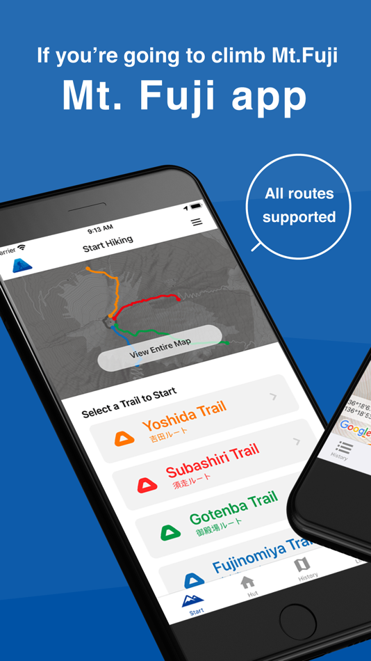
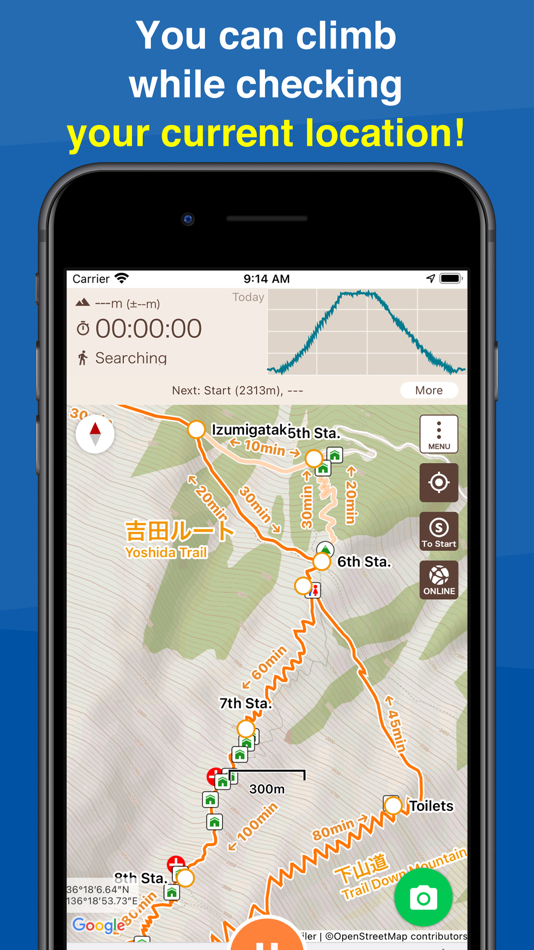
(1) Offline trail map
Mt. Fuji trail maps can be used offline.
Even in the mountains where there is no internet connection, you can use the signal from GPS satellites to locate your current location and display the map.
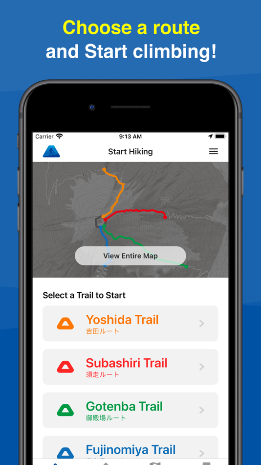
(2) Easy preparation
You can start hiking by simply selecting your trail route from the four routes commonly used for climbing Mt. Fuji.
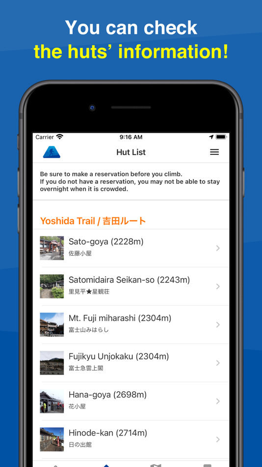
(3) Mountain hut/lodge information
You can also make reservations by phone or through the website for huts located along your planned route.
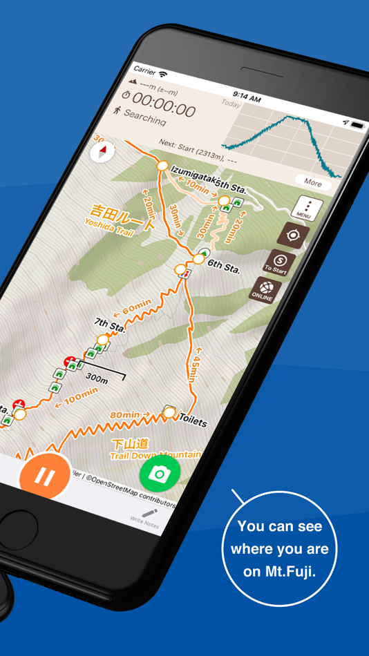
(4) Leave history of your hike
When you start climbing a mountain, you can store a GPS log of your hike using GPS.
Even if you are on airplane mode or out of range, if the sky is open, you can store a GPS log using satellite signals.
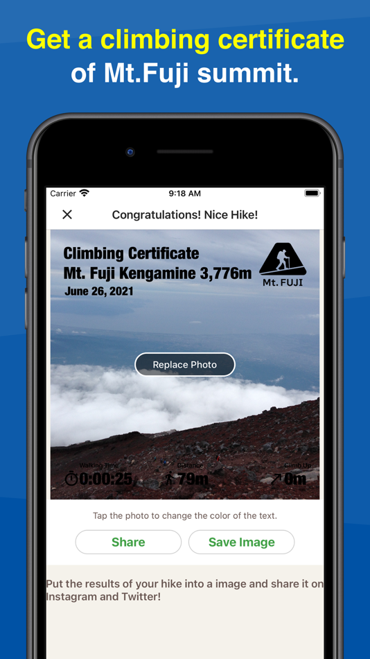
After you finished your hike, you can get your own Climbing Certificate of Mt. Fuji.
(5) Voice notification of wrong way
When you deviate from the planned route, you will be notified by voice.
You can also use the speech function that periodically notifies you of the current time and elevation after you start climbing.
(6) Easy to keep a record of your hike
You can easily create a record of your hike using the GPS logs and photos you took while climbing!
You can also export the GPS log or post it directly to Yamareco (in Japanese only).
(7) Latest Mt. Fuji conditions
By signing in YamaReco, you can check other people's Mt. Fuji records and check the current mountain conditions.
Knowing the current mountain conditions can help you prepare appropriately.
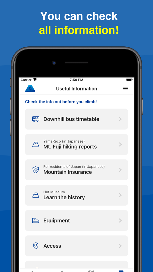
(8) Useful Information
The app includes information such as downhill bus timetable, mountain insurance, equipment, access, and related links useful for climbing Mt. Fuji.
Notes
When keeping a GPS log, the GPS function is used continuously in the background, which may drain the battery faster than apps that do not use GPS.
Continued use of GPS running in the background can dramatically decrease battery life.
Please be sure to bring a paper map, compass, spare batteries, and power cable with you when climbing mountains.
To use some of the functions of this application, you will need to register as a user with YamaReco.
How to use the application
https://sites.google.com/view/fuji-ios-en/
螢幕擷取畫面
新功能
- 版本: 1.30
- 發佈日期:
- Version 1.30
- Changed the warning location, number of warnings, and wording before the junction.
價錢
- 今天: 免費
- 最小值: 免費
- 最大值: 免費
追蹤票價
開發人員
- Yamareco Inc.
- 平台: Android 應用程式 (4) iOS 應用程式 (4)
- 清單: 0 + 0
- 點數: 0 + 6,066 ¡
- 排名: 0
- 評測: 0
- 折扣: 0
- 影片: 0
- RSS: 訂閱
點數
0 ☹️
排名
0 ☹️
清單
0 ☹️
評測
成為第一個評論 🌟
其他資訊
- 🌟 分享
- App Store
你可能還喜歡
-
- GPS Navigation - Map Direction
- iOS 應用程式: 地圖與導航 由: Ravi Munjani
- 免費
- 清單: 0 + 0 排名: 0 評測: 0
- 點數: 0 + 69 (4.2) 版本: 1.9 GPS Navigation with voice navigation, live map, traffic, offline Gps & direction. GPS Navigation with voice navigation, live map, traffic, offline Gps & direction. Map GPS navigation ... ⥯
-
- GPS Navigation, Map Direction
- iOS 應用程式: 地圖與導航 由: Divyang Katharotiya
- 免費
- 清單: 0 + 0 排名: 0 評測: 0
- 點數: 0 + 50 (4.7) 版本: 1.3 GPS Navigation with voice navigation, live map, traffic, offline Gps & direction. GPS Navigation with voice navigation, live map, traffic, offline Gps & direction. Map GPS navigation ... ⥯
-
- Trail Treker
- iOS 應用程式: 地圖與導航 由: Trail Treker, LLC
- * $1.99
- 清單: 0 + 0 排名: 0 評測: 0
- 點數: 0 + 7 (3.7) 版本: 2.58 Trail Treker is a map viewing tool for use with the Trail Treker map publishing service. Trail Treker works with clubs, tourism agencies and municipalities to make their maps work ... ⥯
-
- GPS-Platform
- iOS 應用程式: 地圖與導航 由: GPS Plateform Ltd
- 免費
- 清單: 0 + 0 排名: 0 評測: 0
- 點數: 0 + 0 版本: 1.2 This is mobile client of GPS-Platform tracking application. To use the application, you need a personal account or access to hosted software. Demo Account Credentials: Username: demo ... ⥯
-
- GPS TechTracker Pro
- iOS 應用程式: 地圖與導航 由: GPS California SA de CV
- 免費
- 清單: 1 + 0 排名: 0 評測: 0
- 點數: 1 + 0 版本: 2.18.11 GPS TechTracker provides you with a powerful tool with real-time capability that includes detailed professional reports, reproduction of the routes used in each trip, multiple alerts, ... ⥯
-
- GPS ASSIST: Vehicle Tracking
- iOS 應用程式: 地圖與導航 由: GPS ASSIST LTD
- 免費
- 清單: 0 + 0 排名: 0 評測: 0
- 點數: 0 + 0 版本: 1.1 GPS ASSIST - Smarter Tracking. Requires a GPS ASSIST device to use this app. Take full control of your vehicle s security with GPS ASSIST, the companion app designed to work ... ⥯
-
- OnPoint Trails: OHV Trail Map
- iOS 應用程式: 地圖與導航 由: Brenda Leon
- * 免費
- 清單: 0 + 0 排名: 0 評測: 0
- 點數: 0 + 12 (4.7) 版本: 1.3 OnPoint Trails: Your Ultimate Offline Off-Road Navigator Discover the freedom of off-roading with OnPoint Trails, the all-in-one app designed for adventurers who seek to explore CA OHV ⥯
-
- My Altimeter GPS Altitude Map
- iOS 應用程式: 地圖與導航 由: Savelii Stepura
- 免費
- 清單: 0 + 0 排名: 0 評測: 0
- 點數: 0 + 5 (5.0) 版本: 1.0.3 My Altitude leverages GPS technology to ascertain your precise geographical position, providing detailed information such as latitude, longitude, altitude (elevation above sea level), ... ⥯
-
- Trucker Path: Truck GPS & Map
- iOS 應用程式: 地圖與導航 由: Trucker Path Inc.
- 免費
- 清單: 1 + 0 排名: 0 評測: 0
- 點數: 0 + 126,139 (4.8) 版本: 6.8.3 North America s most popular app for Truckers. BUILT FOR TRUCKERS, BY TRUCKERS! Get all trucker tools in one FREE APP! Best Trucking APP featured by truckers! Trucker Path is a mapping ⥯
-
- GPS Fleet Manager
- iOS 應用程式: 地圖與導航 由: Optimus GPS Tracking Corp
- 免費
- 清單: 0 + 0 排名: 0 評測: 0
- 點數: 0 + 3 (3.3) 版本: 3.10.22 GPS Fleet Manager App is the mobile version of our tracking platform. - Manage your vehicles and other GPS devices. - Track your vehicle in real time. - Receive alerts by: * Push ... ⥯
-
- FarOut: Offline GPS Trail Maps
- iOS 應用程式: 地圖與導航 由: Atlas Guides DE, Inc.
- 免費
- 清單: 0 + 0 排名: 0 評測: 0
- 點數: 0 + 24,879 (4.8) 版本: 15.0.4 Embark on the adventure of a lifetime with FarOut, the most reliable navigational guide app for long-distance exploration. With over 200 hiking, biking, whitewater rafting and paddling ⥯
-
- Michigan Offroad Trail Map
- iOS 應用程式: 地圖與導航 由: Brendan Kirchner
- $3.99
- 清單: 0 + 0 排名: 0 評測: 0
- 點數: 0 + 37 (3.2) 版本: 5.3.0 This application is your guide to the 4x4 and snowmobile trails of Northern Michigan (Lower and Upper Peninsula). Trail data is stored on the device, so if you are out of cell coverage ⥯
-
- GPS Logistic
- iOS 應用程式: 地圖與導航 由: ADVANCED GPS TECHNOLOGY OOD
- 免費
- 清單: 0 + 0 排名: 0 評測: 0
- 點數: 0 + 0 版本: 5.3.0 The application is designed to show information from company site "prosledi.com", to carry out it's main activity - GPS monitoring of subscribers, for which a contract has been ... ⥯
-
- MineAR: Augmented Reality Map
- iOS 應用程式: 地圖與導航 由: Map Life, LLC
- * 免費
- 清單: 0 + 0 排名: 0 評測: 0
- 點數: 0 + 5 (5.0) 版本: 2.40.15 Data you can grasp. As a geoscience professional, we know you want an easier way to see your GIS data while you re in the field. MineAR allows you to do exactly that. Our app ... ⥯