| Προγραμματιστής: | Aerosoft GmbH (105) | ||
| Τιμή: | Δωρεάν | ||
| Κατατάξεις: | 0 | ||
| Κριτικές: | 0 Γράψτε μια κριτική | ||
| Λίστες: | 0 + 0 | ||
| Βαθμοί: | 1 + 3 (2.3) ¡ | ||
| App Store | |||
Περιγραφή
")
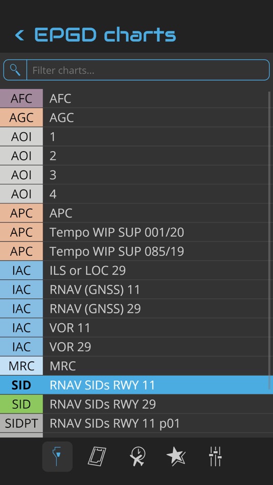
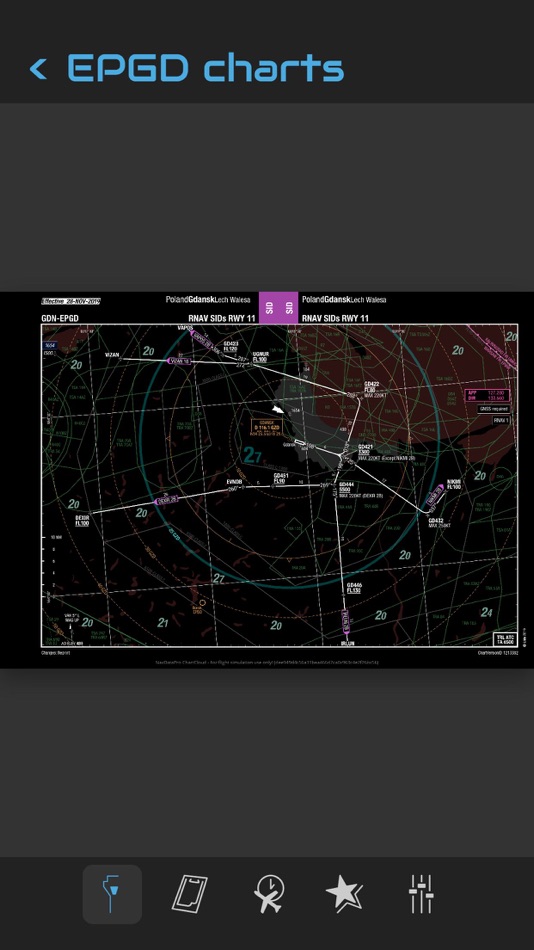
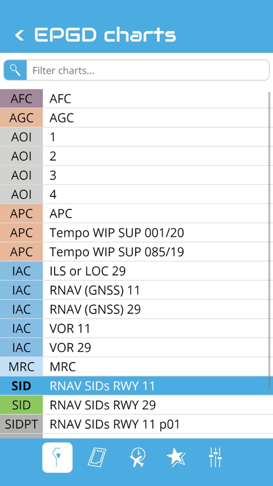
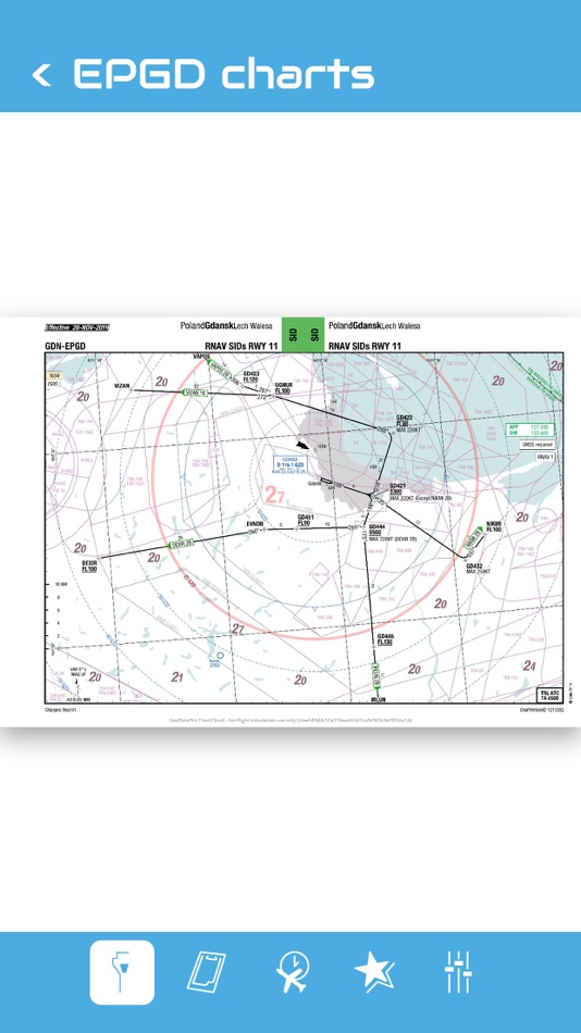
Like the navdata the chart data are supplied by Lufthansa Sytems and are used in real world aviation by more than 180 airlines throughout the world. The chart data will be updated monthly. Every time the user logs in he will get access to the up-to-date charts automatically. You don’t have to do anything to get the charts updated. The NavDataPro Charts Desktop Client is an easy to handle user interface. It allows you to choose an airport, select and view the charts and print a chart.
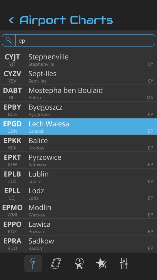
You can search an airport in the airport list. Simply enter your departure, destination and alternate airport in the Quick Flight menu for a quick access to the airport charts. Use the kneeboard feature during your flight to have all needed charts handy.
Στιγμιότυπα οθόνης
Τι νέο υπάρχει
- Εκδοχή: 1.0.3
- Ενημερώθηκε:
Τιμή
- Σήμερα: Δωρεάν
- Ελάχιστο: Δωρεάν
- Μέγιστο: $4.99
Παρακολούθηση τιμών
Προγραμματιστής
- AEROSOFT GMBH
- Πλατφόρμες: iOS Εφαρμογές (1) iOS Παιχνίδια (3) macOS Παιχνίδια (1) Steam Παιχνίδια (64) GOG Παιχνίδια (2) PlayStation Παιχνίδια (14) Xbox Παιχνίδια (20)
- Λίστες: 3 + 0
- Βαθμοί: 11 + 50,101 ¡
- Κατατάξεις: 0
- Κριτικές: 0
- Εκπτώσεις: 0
- Βίντεο: 70
- RSS: Εγγραφή
Βαθμοί
-

- 1,560 바람처어럼
- +1

Κατατάξεις
0 ☹️
Λίστες
0 ☹️
Κριτικές
Γίνε ο πρώτος που θα αξιολογήσει 🌟
Πρόσθετες πληροφορίες
- Εκδοχή: 1.0.3
- ID: aerosoft.ndp.mobileapp
- Κατηγορία:
iOS Εφαρμογές›Πλοήγηση - Λειτουργικό σύστημα:
Apple Watch,iPad,iPhone,iOS 10.0 και νεότερες εκδόσεις - Μέγεθος:
14 Mb - Υποστηριζόμενη γλώσσα:
English - Αξιολόγηση περιεχομένου:
4+ - App Store Εκτίμηση:
2.3(3) - Ενημερώθηκε:
- Ημερομηνία έκδοσης:
Μπορεί επίσης να σας αρέσει
-
- Approach Charts
- iOS Εφαρμογές: Πλοήγηση Με: Candidus LLC
- * Δωρεάν
- Λίστες: 0 + 0 Κατατάξεις: 0 Κριτικές: 0
- Βαθμοί: 0 + 5 (2.0) Εκδοχή: 2.7.0 FAA Instrument Approach charts (Terminal Procedures) for the US - Includes Airport diagrams, Minimums, STARS and DPs - Includes detailed airport and runway information for all US ... ⥯
-
- Navigraph Charts
- iOS Εφαρμογές: Πλοήγηση Με: Navigraph
- Δωρεάν
- Λίστες: 0 + 1 Κατατάξεις: 0 Κριτικές: 0
- Βαθμοί: 0 + 2,195 (4.9) Εκδοχή: 8.38.3 Looking for the most comprehensive software solution for flight simulation? Navigraph Charts is your co-pilot. Navigraph Charts 8 has been developed with emphasis on delivering a ... ⥯
-
- i-Boating: Marine Charts & Gps
- iOS Εφαρμογές: Πλοήγηση Με: Bist LLC
- Δωρεάν
- Λίστες: 0 + 1 Κατατάξεις: 0 Κριτικές: 0
- Βαθμοί: 1 + 13,641 (4.5) Εκδοχή: 162.0.0 This App offers access to Marine Charts for USA,Canada,UK/Ireland,Germany,Netherlands/Holland & Europe Rivers (Danube,Drava,Rhein etc). Coverage includes NOAA marine vector ... ⥯
-
- PRO CHARTS - Marine Navigation
- iOS Εφαρμογές: Πλοήγηση Με: MiraTrex, Inc.
- Δωρεάν
- Λίστες: 0 + 0 Κατατάξεις: 0 Κριτικές: 0
- Βαθμοί: 0 + 8,363 (4.5) Εκδοχή: 5.70 MiraTrex PRO CHARTS™ is a powerful, yet easy-to-use marine navigation system. Whether you re a fisherman, weekend cruiser, sailor, diver, jet-skier, or an offshore captain needing to ... ⥯
-
- Nautical Charts & Maps
- iOS Εφαρμογές: Πλοήγηση Με: LW Brands, LLC
- $8.99
- Λίστες: 0 + 0 Κατατάξεις: 0 Κριτικές: 0
- Βαθμοί: 0 + 3,711 (4.6) Εκδοχή: 1.13 Main Features Include: + NOAA Electronic Navigational Charts (ENC) + NOAA Weather Map Overlays -- ELECTRONIC NAVIGATION CHARTS -- Electronic Navigational Charts (ENC) are vector data ... ⥯
-
- Flytomap All in One HD Charts
- iOS Εφαρμογές: Πλοήγηση Με: Flytomap
- * $14.99
- Λίστες: 0 + 0 Κατατάξεις: 0 Κριτικές: 0
- Βαθμοί: 2 + 4 (3.3) Εκδοχή: 6.5.10 FlyToMap™ is a valid and interesting alternative, Benetti Yachts The charts downloaded are resident in the app. No internet connection required! Flytomap All In One HD works on all ... ⥯
-
- Orca: Boat GPS, Charts, Routes
- iOS Εφαρμογές: Πλοήγηση Με: Orca Technologies AS
- Δωρεάν
- Λίστες: 0 + 1 Κατατάξεις: 0 Κριτικές: 0
- Βαθμοί: 0 + 217 (4.5) Εκδοχή: 2025.41.1 The ultimate boating App - Orca * Crisp Online and Offline Nautical Charts * Modern chart design to maximize legibility. * Satellite Maps to ease your approaches * Tailored routes for ... ⥯
-
- iSailGPS NZ : Nautical Charts
- iOS Εφαρμογές: Πλοήγηση Με: James Associates Inc.
- $1.99
- Λίστες: 0 + 0 Κατατάξεις: 0 Κριτικές: 0
- Βαθμοί: 1 + 0 Εκδοχή: 9.6.5 Unleash the navigation potential of your iPhone or iPad with SailGPS NZ! Turn your device into a high-performance GPS receiver with LINZ RNC Nautical Charts, even without a cell ... ⥯
-
- NV Charts GPS Navigation AIS
- iOS Εφαρμογές: Πλοήγηση Με: NV Chart Group GmbH
- Δωρεάν
- Λίστες: 0 + 0 Κατατάξεις: 0 Κριτικές: 0
- Βαθμοί: 0 + 105 (4.4) Εκδοχή: 2.744.232 Enhance your navigation experience with a seamless navigation solution that provides up-to-date digital nautical charts, comprehensive harbour information, and a full suite of ... ⥯
-
- Aeronautical & Aviation Charts
- iOS Εφαρμογές: Πλοήγηση Με: Corporate Smalltalk Consulting Ltd
- $15.99
- Λίστες: 0 + 0 Κατατάξεις: 0 Κριτικές: 0
- Βαθμοί: 0 + 1 (1.0) Εκδοχή: 2.6.0 Got a PDF or a TIFF of an Aeronautical chart? Is that chart 31x24 inches with typography the size of a grain of rice? None of the document readers in the App store can view and scroll ... ⥯
-
- Hip Charts
- iOS Εφαρμογές: Πλοήγηση Με: Walk About Apps
- Δωρεάν
- Λίστες: 0 + 0 Κατατάξεις: 0 Κριτικές: 0
- Βαθμοί: 0 + 6 (3.7) Εκδοχή: 2.1 Hip Charts brings NOAA ENC nautical charts to your fingertips... for FREE! NOAA charts automatically load as you move the map and can be downloaded via cellular or WiFi connections. ... ⥯
-
- NZ Charts
- iOS Εφαρμογές: Πλοήγηση Με: Right Place Resources
- $2.99
- Λίστες: 0 + 0 Κατατάξεις: 0 Κριτικές: 0
- Βαθμοί: 0 + 0 Εκδοχή: 1.02 This App contains the complete set of LINZ hydrographic raster charts for New Zealand. The charts are all installed with the app for out-of-the-box offline use with no additional ... ⥯
-
- RT-Nav
- iOS Εφαρμογές: Πλοήγηση Με: Hilton's Fishing Charts, L.L.C.
- Δωρεάν
- Λίστες: 0 + 0 Κατατάξεις: 0 Κριτικές: 0
- Βαθμοί: 0 + 8 (3.0) Εκδοχή: 1.178 Hilton's Realtime-Navigator Mobile Navigation Application. Navigate on almost real-time imageries such as sea surface temperatures, chlorophyll, surface currents, altimetry, and ... ⥯
-
- Imray Navigator
- iOS Εφαρμογές: Πλοήγηση Με: Imray
- * Δωρεάν
- Λίστες: 0 + 0 Κατατάξεις: 0 Κριτικές: 0
- Βαθμοί: 0 + 7 (1.0) Εκδοχή: 2.7 Imray's marine chart plotter for sailors, divers, canoeists, fishermen and anyone involved with making way at sea. Nautical charts by Imray and other publishers Easy to use for passage ⥯