| Kehittäjä: | Toonsy Net (6) | ||
| Hinta: | * Ilmainen | ||
| Rankingissa: | 0 | ||
| Arvostelut: | 0 Kirjoita arvostelu | ||
| Listat: | 0 + 0 | ||
| Pisteet: | 0 + 8 (4.5) ¡ | ||
| App Store | |||
Kuvaus
")
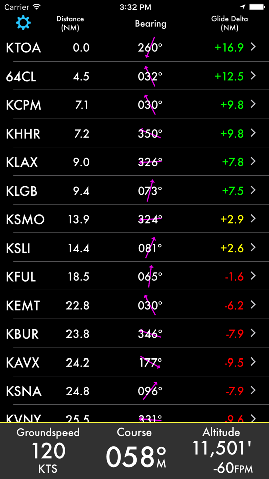
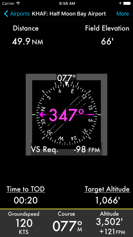
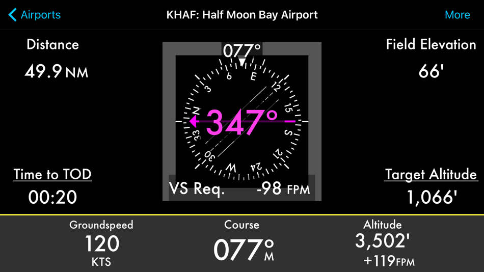
• Distance from current location
• Field Elevation
• Descent rate required
• Time to Top of Descent (TOD)
• Bearing
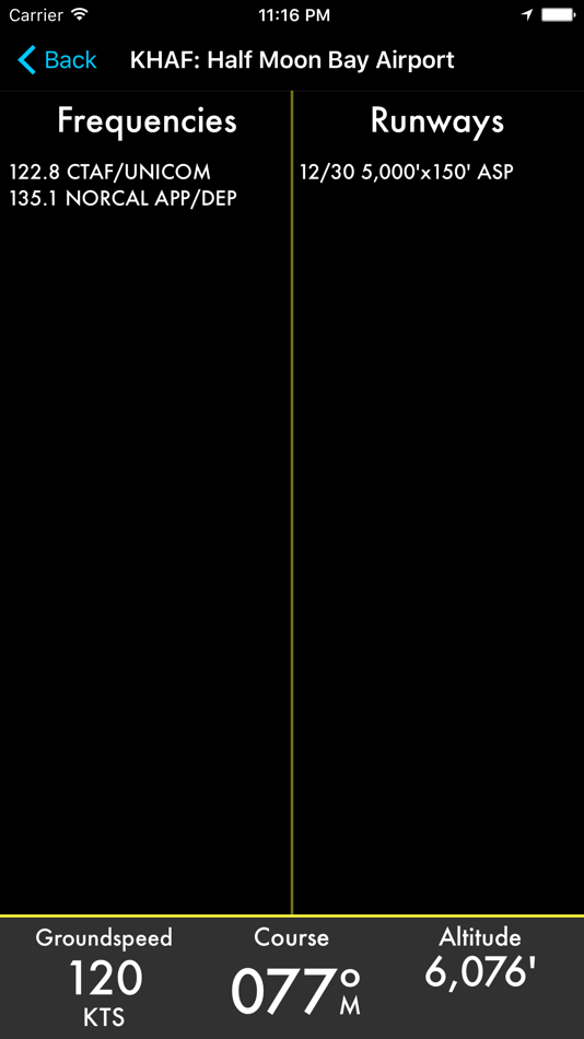
• Frequencies
• Runways
• Glide distance delta
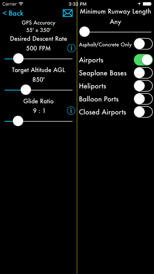
Additionally your current speed, course, altitude and vertical speed are displayed. Tapping on the information button, Time to TOD or Target Altitude allows you to customize the desired descent rate.
All data is updated in real time as you fly. You may choose a nearby airport or select an airport by identifier by scrolling down on the airport list. Filter by runway length and surface type and choose any of the following: airports, seaplane bases, heliports, balloon ports and closed airports.
You may optionally provide a glide ratio for your aircraft. The glide distance long or short of the selected airport is then displayed and is conveniently color coded. A positive, green glide delta indicates the glide distance has been estimated to exceed the distance to the airport with a 25% safety margin.
Runway headings, if known, are used to draw runways on the heading indicator. If the magenta arrow is pointed straight up and aligned with a runway then you are headed straight in.
Worldwide airport information is provided by multiple sources. Canada, Europe and all continents are covered! For more information go to ourairports.com/world.html. Database updates are performed daily.
Your location and altitude is provided by your device's location services. If location or altitude is not available that information will not be displayed however you can still search for an airport by identifier. Unfortunately external GPS devices are generally NOT compatible.
You must be moving for course information and the magenta relative bearing arrow to be displayed.
The Watch app has many of the same features and fits on your wrist. See distances to nearby airports or bearing to a selected airport. Frequencies and runway lengths can be seen with a swipe. A green glide icon or delta indicates glideability is likely.
Just like the iPhone and iPad app, the Watch app requires GPS information to locate nearby airports and relative bearing. Additionally, altitude is needed to calculate descent rates.
Feedback and feature requests are appreciated. Thanks!
Subscription Fine Print
----------------------
- 1 month FREE trial
- Database Subscription or Apple Watch Subscription is required for new users
- The subscription is for 1 year and updated data is available daily
- The annual subscription is $11.99/year or $17.99/year for Watch
- Payment will be charged to iTunes Account at confirmation of purchase
- Subscription automatically renews unless auto-renew is turned off at least 24-hours before the end of the current period
- Account will be charged for renewal within 24-hours prior to the end of the current period, and identify the cost of the renewal
- Subscriptions may be managed by the user and auto-renewal may be turned off by going to the user's Account Settings after purchase
- No cancellation of the current subscription is allowed during active subscription period
- Privacy policy and terms of use are located at: http://toonsy.net/privacy.html
- Any unused portion of a free trial period, if offered, will be forfeited when the user purchases a subscription to that publication.
Näyttökuvat
Hinta
-
* Sovelluksen sisäiset ostot - Tänään: Ilmainen
- Vähintään: Ilmainen
- Enintään: Ilmainen
Seuraa hintoja
Kehittäjä
- Toonsy Net
- Alustat: iOS Sovellukset (6)
- Listat: 0 + 0
- Pisteet: 0 + 30 ¡
- Rankingissa: 0
- Arvostelut: 0
- Alennukset: 0
- Videot: 0
- RSS: Tilaa
Pisteet
0 ☹️
Rankingissa
0 ☹️
Listat
0 ☹️
Arvostelut
Ole ensimmäinen tarkistaa 🌟
Lisätietoja
- Versio: 8.1
- Luokka:
iOS Sovellukset›Navigointi - Käyttöjärjestelmä:
Apple Watch,iPad,iPhone,iOS 17.0 tai uudempi - Koko:
50 Mb - Tuettu kieli:
English - Sisällön ikärajoitus:
4+ - App Store Luokitus:
4.5(8) - Päivitetty:
- Julkaisupäivämäärä:
- 🌟 Jaa
- App Store
Saatat myös pitää
-
- Google Maps
- iOS Sovellukset: Navigointi Tekijänä: Google
- Ilmainen
- Listat: 14 + 9 Rankingissa: 5 (3) Arvostelut: 5 (1)
- Pisteet: 5 + 6,942,543 (4.7) Versio: 25.45.1 Explore and navigate the world with confidence using Google Maps. Find the best routes with live traffic data and real-time GPS navigation for driving, walking, cycling, and public ... ⥯
-
- Waze Navigation & Live Traffic
- iOS Sovellukset: Navigointi Tekijänä: Waze Inc.
- Ilmainen
- Listat: 9 + 4 Rankingissa: 5 (1) Arvostelut: 0
- Pisteet: 1 + 3,101,115 (4.8) Versio: 5.13.0.2 Know what's ahead on the road with the help from other drivers. Waze is a live map that harnesses the local knowledge of tens of millions of drivers around the world. Drivers safely ... ⥯
-
- Transit • Subway & Bus Times
- iOS Sovellukset: Navigointi Tekijänä: Transit App, Inc.
- Ilmainen
- Listat: 3 + 0 Rankingissa: 0 Arvostelut: 0
- Pisteet: 0 + 834,383 (4.6) Versio: 6.0.9 Transit is your real-time urban travel companion. Open the app to instantly see accurate next departure times, track buses and trains near you on the map, and see upcoming transit ... ⥯
-
- SpotHero: #1 Rated Parking App
- iOS Sovellukset: Navigointi Tekijänä: SpotHero, Inc.
- Ilmainen
- Listat: 0 + 0 Rankingissa: 0 Arvostelut: 0
- Pisteet: 0 + 352,085 (4.8) Versio: 8.0.0 Park smarter with the SpotHero iPhone app. SpotHero helps you get everywhere, easier by making it fast and convenient to find and reserve parking in major cities. Plus, when you book ... ⥯
-
- onX Hunt: GPS Hunting Maps
- iOS Sovellukset: Navigointi Tekijänä: onXmaps, Inc.
- Ilmainen
- Listat: 0 + 0 Rankingissa: 0 Arvostelut: 0
- Pisteet: 1 + 257,137 (4.9) Versio: 25.43.0 Navigate your next hunt and view species distribution, topo maps, hunting units, and more. Whether you re a private or public land hunter, know where you stand with land ownership ... ⥯
-
- MTA TrainTime
- iOS Sovellukset: Navigointi Tekijänä: Metropolitan Transportation Authority
- Ilmainen
- Listat: 0 + 0 Rankingissa: 0 Arvostelut: 0
- Pisteet: 0 + 207,246 (4.9) Versio: 9.13.3 The TrainTime app provides a one-stop shop for Long Island Rail Road and Metro-North Railroad customers, where riders can buy and use tickets, plan their trips, track their trains, and ⥯
-
- ParkWhiz - #1 Parking App
- iOS Sovellukset: Navigointi Tekijänä: ParkWhiz, Inc.
- Ilmainen
- Listat: 0 + 0 Rankingissa: 0 Arvostelut: 0
- Pisteet: 0 + 187,388 (4.8) Versio: 11.3.2 Take the hassle out of parking with the ParkWhiz app. Find parking in any major city, compare prices, plus save up to 50% when you book in advance. Free yourself from parking hassles ... ⥯
-
- Exxon Mobil Rewards+
- iOS Sovellukset: Navigointi Tekijänä: Exxon Mobil Corporation
- Ilmainen
- Listat: 0 + 0 Rankingissa: 0 Arvostelut: 0
- Pisteet: 0 + 185,800 (4.8) Versio: 6.5.2 Go on. Fuel Up. Earn More. Pay Less. The Exxon Mobil Rewards+ app is your secure, contactless way to pay at the pump or in-store while earning valuable rewards points every time you ... ⥯
-
- PlugShare: Charging Stations
- iOS Sovellukset: Navigointi Tekijänä: Recargo, Inc.
- Ilmainen
- Listat: 0 + 0 Rankingissa: 0 Arvostelut: 0
- Pisteet: 0 + 131,041 (4.7) Versio: 7.30.0 Download the most accurate EV and Tesla charging station map. PlugShare is the world s largest EV driver community. Drivers contribute station reviews and photos to help the EV ... ⥯
-
- Trucker Path: Truck GPS & Map
- iOS Sovellukset: Navigointi Tekijänä: Trucker Path Inc.
- Ilmainen
- Listat: 1 + 0 Rankingissa: 0 Arvostelut: 0
- Pisteet: 0 + 124,920 (4.8) Versio: 6.8.2 North America s most popular app for Truckers. BUILT FOR TRUCKERS, BY TRUCKERS! Get all trucker tools in one FREE APP! Best Trucking APP featured by truckers! Trucker Path is a mapping ⥯
-
- Avenza Maps: Offline Mapping
- iOS Sovellukset: Navigointi Tekijänä: Avenza Systems Inc.
- Ilmainen
- Listat: 0 + 1 Rankingissa: 0 Arvostelut: 0
- Pisteet: 0 + 122,526 (4.8) Versio: 262 Avenza Maps, #1 app for hiking, biking and all trails. Featuring maps from National Geographic, national parks and more! On your next adventure, stay on track with GPS using offline ... ⥯
-
- New York Subway MTA Map NYC
- iOS Sovellukset: Navigointi Tekijänä: Mapway Limited
- Ilmainen
- Listat: 0 + 0 Rankingissa: 0 Arvostelut: 0
- Pisteet: 0 + 107,697 (4.6) Versio: 5.5.6 New York Subway uses the official MTA subway map and includes a helpful transit route planner. With over 12 million downloads worldwide this NYC subway map is free to download and will ⥯
-
- Speedometer Simple
- iOS Sovellukset: Navigointi Tekijänä: WATT APPS
- Ilmainen
- Listat: 0 + 0 Rankingissa: 0 Arvostelut: 0
- Pisteet: 0 + 101,388 (4.7) Versio: 2025.9.1 Speedometer Simple is a simple speedometer that is very easy to use. This app uses phone's GPS to accurately determine your speed. Speedometer has large fonts and supports mph, km/h, ... ⥯
-
- Citymapper: All Live Transit
- iOS Sovellukset: Navigointi Tekijänä: Citymapper Limited
- Ilmainen
- Listat: 0 + 3 Rankingissa: 0 Arvostelut: 0
- Pisteet: 1 + 96,409 (4.9) Versio: 11.36.3 Instantly compare your travel options in real-time across all transport modes globally! Easily navigate your city with turn-by-turn directions for all your public transportation, ... ⥯