| Nhà phát triển: | RoadTour LLC (4) | ||
| Giá bán: | $1.99 | ||
| Xếp hạng: | 0 | ||
| Đánh giá: | 0 Viết đánh giá | ||
| Danh sách: | 0 + 0 | ||
| Điểm: | 0 + 14 ¡ | ||
| Điểm + 1 | |||
Mô tả
")
*** Extremely easy to use and looks great. [Trek & Mountain Magazine]
*** The best way to access Ordnance Survey Maps in digital form. [Stuff Magazine]
*** The perfect tool for navigating off-road. Great Fun! [Outdoors Magazine]
OutDoors GB makes it easy to enjoy the great British countryside with confidence.
• Trusted by hikers, cyclists, ramblers, and outdoor instructors.
• At a fraction of the cost of a dedicated GPS device, spend less time staring at maps and more time stretching your legs.
• The only outdoors navigation app that combines all your favorite OS Maps, with the features you need in a simple interface.
• There is now no reason to ever get lost again.
• Simply create a route on Ordnance Survey maps..…and go!
OutDoors GB takes outdoors navigation to new heights:
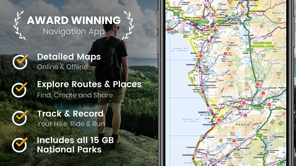
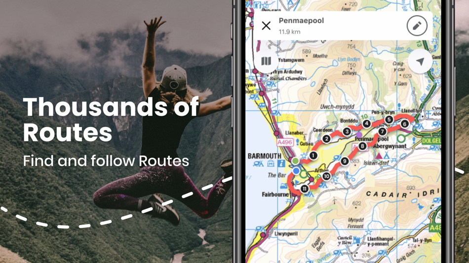
• HIKERS: Find or plan a route by choosing from over 200,000 free routes. Then navigate using the built in compass & simple direction view. Track your journey by hitting the record button and finally save and share favorite spots by creating a ‘My Places” list
• RUNNERS: Add variety to your running routes by searching our database of local routes based on distance and elevation. Track your stats and save your favorite places on the routes for great views, stretching, resting and water fountains by creating your personal point of interests list
• CYCLISTS: Find a route that matches your level of intensity by searching entries by distance and elevation. Or craft your own perfect biking path with the route builder. Use the hands free mode while biking and track your route statistics
• PHOTOGRAPHERS: Find beautiful landscapes by searching through over 250,000 points of interests. Find or plan your route to get there by using distance markers and confidently explore offline with Satellite, Terrain, Hybrid, and Road maps
EXPLORE CONFIDENTLY
• Dependable anywhere - Break free of phone signals and download maps to use and explore anywhere
• Find, plan, share, and record routes with statistics & elevation profiles
• 200,000+ Free routes available for route planning
• Unlimited access to online & offline OS Maps (PRO)
ORDNANCE SURVEY MAPS
• Download any Landranger 1:50k, Explorer 1:25k Ordnance Survey maps
• Quick access to download OS Map regions: Regions (1:50k), Counties (1:25k) or National Parks (1:25k)
POWERFUL GPS FUNCTIONS
• Fully functioning GPS at a fraction of the cost of a dedicated GPS device
• Finds your location in seconds- accurate to within 10 metres
• Create a route, with distance markers, by tapping on the screen
• Follow a planned route using the in-built compass
• Create & Share 'My Places' list (picnic area, views etc)
• 250,000 points of interest included
WEBSITE & ONLINE COMMUNITY (150,000+ MEMBERS)
• Do all your planning (or post trip analysis) with OS Maps
• Plan, edit and share your routes via Email, Text, Social, etc.
You can subscribe to OutDoors PRO for unlimited OS Maps & Premium Routes. Your subscription will be £30 for 1 year from the date of subscription, charged to your iTunes Account, and will automatically renew unless cancelled at least 24 hours before the end of the current period. Auto-renew can be turned off anytime by going to your Account Settings in iTunes after purchase. No cancellation of the current subscription is allowed during active subscription period.
Note: Continued use of GPS running in the background can dramatically decrease battery life.
Terms of Use: http://outdoorsgps.com/terms
Privacy Policy: http://outdoorsgps.com/privacy
Ảnh chụp màn hình


Tính năng mới
- Phiên bản: 6.5.7
- Cập nhật:
- * Bug Fixes
Giá bán
- Hôm nay: $1.99
- Tối thiểu: $1.99
- Tối đa: $1.99
Theo dõi giá
Nhà phát triển
- RoadTour LLC
- Nền tảng: Android Ứng dụng (1) iOS Ứng dụng (3)
- Danh sách: 0 + 0
- Điểm: 0 + 668 ¡
- Xếp hạng: 0
- Đánh giá: 0
- Giảm giá: 0
- Video: 0
- RSS: Đăng ký
Điểm
Không tìm thấy ☹️
Xếp hạng
Không tìm thấy ☹️
Danh sách
Không tìm thấy ☹️
Đánh giá
Hãy là người đầu tiên đánh giá!
Thông tin bổ sung
- Danh mục:
iOS Ứng dụng›Bản đồ và dẫn đường - HĐH:
iPad,iPhone,iOS 13.0 trở lên - Kích thước:
127 Mb - Ngôn ngữ được hỗ trợ:
English - Xếp hạng nội dung:
4+ - App Store Xêp hạng:
5.0(14) - Cập nhật:
- Ngày phát hành:
Danh bạ
- Trang web:
 https://outdoorsgps.com
Bạn cũng có thể thích
-
- OS Maps: Walking & Bike Trails
- iOS Ứng dụng: Bản đồ và dẫn đường Bởi: Ordnance Survey
- * Miễn phí
- Danh sách: 0 + 0 Xếp hạng: 0 Đánh giá: 0
- Điểm: 0 + 229 Phiên bản: 5.0.6 Create your adventures your way & let OS Maps guide you on stunning routes across the UK & beyond. Get more from the outdoors, with more freedom to explore, more confidence to tackle ...
-
- 4WD Maps - Offline Topo Maps
- iOS Ứng dụng: Bản đồ và dẫn đường Bởi: Hema Maps
- $64.99
- Danh sách: 0 + 0 Xếp hạng: 0 Đánh giá: 0
- Điểm: 0 + 4 Phiên bản: 2.4.2 Best value Hema App. The one-time cost includes all Hema 4WD maps, without any recurring subscriptions. Use offline mapping and your device s in-built GPS receiver to see where you are
-
- Maps 3D PRO - Hike & Bike
- iOS Ứng dụng: Bản đồ và dẫn đường Bởi: movingworld GmbH
- $3.99
- Danh sách: 1 + 4 Xếp hạng: 0 Đánh giá: 0
- Điểm: 0 + 194 Phiên bản: 6.6 Enjoy exploring the great outdoors? If you re a fan of biking, hiking and running then Maps 3D is the ideal app designed for planning your outdoor adventures. Whereas other mapping ...
-
- Offline Map Navigation
- iOS Ứng dụng: Bản đồ và dẫn đường Bởi: VirtualMaze
- Miễn phí
- Danh sách: 0 + 0 Xếp hạng: 0 Đánh giá: 0
- Điểm: 0 + 258 Phiên bản: 5.0.6 Search, Get Directions & Navigate anywhere even without internet connection Turn-by-turn route instructions & real-time navigation Find directions for car, motorbike, bicycle or walk ...
-
- Offline Maps Nav by Karta GPS
- iOS Ứng dụng: Bản đồ và dẫn đường Bởi: Karta
- * Miễn phí
- Danh sách: 0 + 0 Xếp hạng: 0 Đánh giá: 0
- Điểm: 0 + 3 Phiên bản: 2.46.06 Navigate in Germany and download any map from all over the world! This special German version offers free traffic and Speed Radars information with lifetime updates. All maps are free ...
-
- Offline Guide: Cedar Point
- iOS Ứng dụng: Bản đồ và dẫn đường Bởi: Advantage Inc.
- Miễn phí
- Danh sách: 0 + 0 Xếp hạng: 0 Đánh giá: 0
- Điểm: 0 + 1,075 Phiên bản: 1.2 Maximize your Cedar Point experience with The Unofficial Universal Cedar Point App! Find information on rides, dining options, aqua rides, shows, and more for Cedar Point and Soak City
-
- Goose Maps for Watch
- iOS Ứng dụng: Bản đồ và dẫn đường Bởi: GOOSE MAPS LTD
- Miễn phí
- Danh sách: 0 + 0 Xếp hạng: 0 Đánh giá: 0
- Điểm: 0 + 181 Phiên bản: 1.3 Features - Navigate easily everywhere Our pedestrian and bike navigation perfectly work even if your iPhone stayed at home. - Search objects you need Our search helps you to find ...
-
- Local Maps
- iOS Ứng dụng: Bản đồ và dẫn đường Bởi: Local Maps Inc
- Miễn phí
- Danh sách: 0 + 0 Xếp hạng: 0 Đánh giá: 0
- Điểm: 0 + 4 Phiên bản: 1.3 Find the funnel cake stand or next horse race faster than ever before with this free and easy to use navigation platform for fairs and festivals. Start enjoying your time by finding ...
-
- Yango Maps
- iOS Ứng dụng: Bản đồ và dẫn đường Bởi: Direct Cursus Computer Systems Trading
- Miễn phí
- Danh sách: 0 + 0 Xếp hạng: 0 Đánh giá: 0
- Điểm: 0 + 102 Phiên bản: 18.0 Navigate the city easily, whether you're driving, walking, or using public transport. With our GPS-powered app, you can see your precise location and get convenient directions straight
-
- NZ Topo Maps
- iOS Ứng dụng: Bản đồ và dẫn đường Bởi: Rajan Fernandez
- Miễn phí
- Danh sách: 0 + 0 Xếp hạng: 0 Đánh giá: 0
- Điểm: 0 + 15 Phiên bản: 1.9 Offline topographic maps of New Zealand. Topo250 and Topo50 maps direct from the LINZ data service Download just the maps you need and delete the ones you don't to save device storage ...
-
- Apple Maps
- iOS Ứng dụng: Bản đồ và dẫn đường Bởi: Apple
- Miễn phí
- Danh sách: 3 + 1 Xếp hạng: 4 (1) Đánh giá: 0
- Điểm: 1 + 23,006 Phiên bản: 1.5 Maps Apple Maps is the best way to navigate and explore the world - all with your privacy protected. What s New: Multi-stop routing lets you add multiple stops along your driving route
-
- BRMB Maps by Backroad Maps
- iOS Ứng dụng: Bản đồ và dẫn đường Bởi: Mussio Ventures Ltd.
- Miễn phí
- Danh sách: 0 + 0 Xếp hạng: 0 Đánh giá: 0
- Điểm: 0 + 11 Phiên bản: 2.4.0 Experience the Great Outdoors of Canada in a whole new way with BRMB Maps' top-rated backcountry maps. Our industry-leading road and trail maps cover all of Canada, and our Smartphone ...
-
- Sygic GPS Navigation & Maps
- iOS Ứng dụng: Bản đồ và dẫn đường Bởi: Sygic a. s.
- * Miễn phí
- Danh sách: 0 + 0 Xếp hạng: 0 Đánh giá: 0
- Điểm: 6 + 54,128 Phiên bản: 24.2.1 Sygic GPS Navigation & Maps is innovative GPS navigation app with monthly-updated offline maps and with precise live traffic & speed camera alerts, both updated in real-time. It s ...
-
- Cartograph 2 Maps
- iOS Ứng dụng: Bản đồ và dẫn đường Bởi: Harald Meyer
- $5.99
- Danh sách: 1 + 0 Xếp hạng: 0 Đánh giá: 0
- Điểm: 0 + 6 Phiên bản: 2.8.1 The Cartograph app views Mapsforge offline vector maps, offline raster maps, and online/WMS maps. It supports tracking, route search, overlays, hillshading, reliefs, track drawing, and
Bạn cũng có thể thích
- iOS Ứng dụng
- Mới iOS Ứng dụng
- Bản đồ và dẫn đường iOS Ứng dụng : Mới
- Video iOS Ứng dụng
- Phổ biến iOS Ứng dụng
- Bản đồ và dẫn đường iOS Ứng dụng : Phổ biến
- Giảm giá iOS Ứng dụng
- Bản đồ và dẫn đường iOS Ứng dụng : Giảm giá
- Xếp hạng iOS Ứng dụng
- Đánh giá iOS Ứng dụng
- Danh sách iOS Ứng dụng
- Điểm iOS Ứng dụng