| 開發人員: | Herenga a Nuku Aotearoa (2) | ||
| 價錢: | 免費 | ||
| 排名: | 0 | ||
| 評測: | 0 寫評論 | ||
| 清單: | 0 + 0 | ||
| 點數: | 0 + 1 (5.0) ¡ | ||
| App Store | |||
描述
")
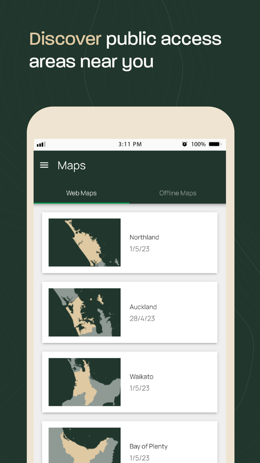
Pocket Maps is developed and owned by Herenga ā Nuku Aotearoa, the Outdoor Access Commission,
and displays a range of maps and layers that are also available on the Herenga ā Nuku mapping system.
Pocket Maps displays Public Access Areas derived by Herenga ā Nuku from cadastral information, which indicate what land is publicly accessible.
The app also contains tracks, recreation spots, huts and campsite layers which are maintained and owned by other government agencies.
Features include:
• Publicly accessible areas in Aotearoa, shown by type
• Range of map layers for outdoor recreation
• Ability to generate elevation profiles
• Get coordinates and share
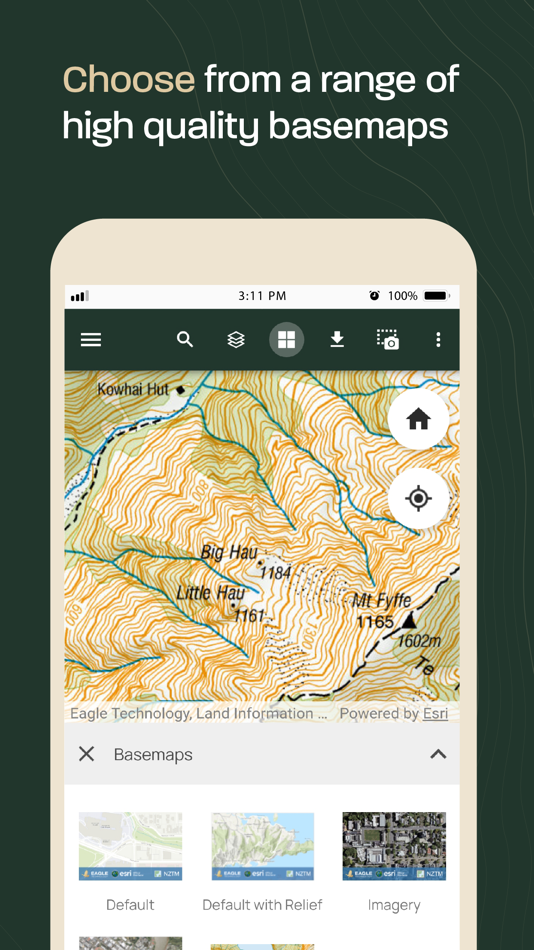
• Selection of high quality basemaps
• Offline map regions
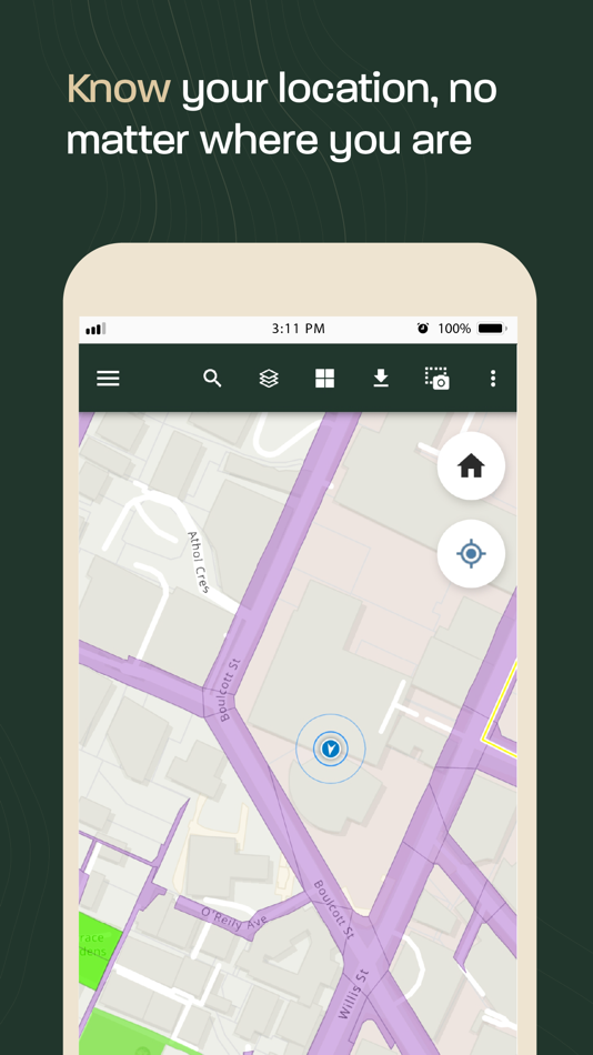
• Find your location
• Draw and measure routes
螢幕擷取畫面
新功能
- 版本: 1.5.1
- 發佈日期:
- New Features - Pocket Maps v1.5
Map Layers
• DOC Huts & Campsites - including locations, weblinks and photos. Provided by Department of Conservation.
• Hunting & Fishing Access Points – including locations, descriptions and weblinks. Provided by Fish & Game New Zealand.
• River & Coastal Access Points – locations, descriptions, and access information. For the Canterbury region only. Provided by Environment Canterbury.
• Tracks & Trails– including Te Araroa, New Zealand Cycle Trail, Department of Conservation and local council tracks.
Basemaps
• Default with Relief – New version of the existing default basemap that also includes a relief hillshade of Aotearoa’s terrain underneath for topographical context. This feature is only available online.
• Imagery with labels – An alternative version to the existing Imagery basemap which also includes dynamic labels for roads, addresses, places, regions and localities. This feature is only available online.
General
• Get coordinates – long pressing the map now drops a pin and generates coordinates for the pin’s location which can be copied to the clipboard or shared using your devices sharing panel.
• Elevation Profiles– allows users to click on a track in the app and see it’s elevation profile in the pop-up. This feature is only available online.
• Help page – updated to include offline help documentation for using Pocket Maps’s interface, tools and data.
• News and Updates page – enables Pocket Maps users to see communications from the developers about new Pocket Maps releases, layers, basemaps and offline data, as well as other general messages such as warnings, alerts and user survey links.
Improvements
• Pop-ups – Pop-ups for all layers have been simplified for easier use with.
• Fields – fields for each layer have been refined and made easier to understand.
• Layer transparency – Public Access Areas layers now have increased transparency by default to ensure ease of use and ability to see underlying basemaps.
• Screenshots – allows users to take a screenshot of the map view and add annotations. These can be shared or saved to their device. Previously part of the “Measure” tool.
• Download map – offline area download interface improved to show download progress bar.
• New look and feel – simplified UI, tab names and colours with Herenga ā Nuku branding.
價錢
- 今天: 免費
- 最小值: 免費
- 最大值: 免費
追蹤票價
開發人員
- Herenga ā Nuku Aotearoa
- 平台: Android 應用程式 (1) iOS 應用程式 (1)
- 清單: 0 + 0
- 點數: 0 + 1 ¡
- 排名: 0
- 評測: 0
- 折扣: 0
- 影片: 0
- RSS: 訂閱
點數
0 ☹️
排名
0 ☹️
清單
0 ☹️
評測
成為第一個評論 🌟
其他資訊
- 版本: 1.5.1
- 類別 :
iOS 應用程式›地圖與導航 - OS:
iPad,iPhone,iOS 13.0 以上版本 - 大小:
198 Mb - 支援的語言 :
Arabic,Bosnian,Bulgarian,Catalan,Chinese,Croatian,Czech,Danish,Dutch,English,Estonian,Finnish,French,German,Greek,Hebrew,Hungarian,Indonesian,Italian,Japanese,Korean,Latvian,Lithuanian,Norwegian,Polish,Portuguese,Romanian,Russian,Serbian,Slovak,Slovenian,Spanish,Swedish,Thai,Turkish,Ukrainian,Vietnamese - 內容分級:
4+ - App Store 評分:
5.0(1) - 發佈日期:
- 發行日期:
- 🌟 分享
- App Store
你可能還喜歡
-
- maps.earth
- iOS 應用程式: 地圖與導航 由: Michael Kirk
- 免費
- 清單: 0 + 0 排名: 0 評測: 0
- 點數: 0 + 4 (3.5) 版本: 1.13 Explore the world and get low stress directions powered by OpenStreetMap. maps.earth is built on open source. We never show you ads or sell your data. We just want a nice map. ⥯
-
- Maps My Location
- iOS 應用程式: 地圖與導航 由: Rohit Bhayani
- 免費
- 清單: 0 + 0 排名: 0 評測: 0
- 點數: 0 + 1 (1.0) 版本: 1.0 A Map My Location app for iOS is a software application designed to assist You in navigating from one location to another using the Global Positioning System (GPS) technology. Key ... ⥯
-
- Maps Address Book
- iOS 應用程式: 地圖與導航 由: Clever Thinking Software Inc.
- * 免費
- 清單: 0 + 0 排名: 0 評測: 0
- 點數: 0 + 11 (4.8) 版本: 1.23 Maps Address Book: Your Complete Address Management Solution Tired of hunting for addresses across multiple map apps? Maps Address Book is the ultimate solution for managing all your ... ⥯
-
- Pocket Earth PRO
- iOS 應用程式: 地圖與導航 由: GeoMagik LLC
- $6.99
- 清單: 5 + 4 排名: 0 評測: 0
- 點數: 5 + 1,786 (4.8) 版本: 3.9 Detailed worldwide maps and travel guides Topographic contour maps for the outdoors Works completely offline even with GPS Great when abroad or in the wilderness, NO data roaming ... ⥯
-
- Maps 3D PRO - Hike & Bike
- iOS 應用程式: 地圖與導航 由: movingworld GmbH
- $3.99
- 清單: 1 + 4 排名: 0 評測: 0
- 點數: 0 + 201 (4.4) 版本: 6.8 Enjoy exploring the great outdoors? If you re a fan of biking, hiking and running then Maps 3D is the ideal app designed for planning your outdoor adventures. Whereas other mapping ... ⥯
-
- Organic Maps: Offline Map
- iOS 應用程式: 地圖與導航 由: Organic Maps
- 免費
- 清單: 1 + 1 排名: 0 評測: 0
- 點數: 3 + 1,009 (4.8) 版本: 2025.11.26 Organic Maps is a fast, detailed offline map and GPS navigation app for travel, hikes, and rides. Plan, import, and record routes, and enjoy smooth guidance without draining your ... ⥯
-
- Maps TV
- iOS 應用程式: 地圖與導航 由: Anass Damri
- $0.99
- 清單: 0 + 0 排名: 0 評測: 0
- 點數: 0 + 0 版本: 1.1 Transform your TV into a powerful mapping experience with Maps TV the ultimate navigation app designed specifically for the big screen. KEY FEATURES: Full Screen Map Experience: Enjoy ... ⥯
-
- Maps Anywhere: Offline GPS
- iOS 應用程式: 地圖與導航 由: Ali Mert TUFEKCI
- 免費
- 清單: 0 + 0 排名: 0 評測: 0
- 點數: 5 + 2 (5.0) 版本: 1.0.0.8 SecureTrek Maps Anywhere - Stay Oriented in the Wild Every year, thousands of people get lost while trekking or exploring the outdoors due to poor visibility, disorientation, or losing ⥯
-
- Goat Maps
- iOS 應用程式: 地圖與導航 由: Goat Maps, inc.
- 免費
- 清單: 0 + 0 排名: 0 評測: 0
- 點數: 0 + 48 (4.7) 版本: 2025.11 Goat Maps is the next-generation navigation app designed for outdoor adventures. Built from the ground up in 2024, Goat Maps offers unmatched reliability and ease of use, perfect for ... ⥯
-
- Maps & GPS: Route Finder
- iOS 應用程式: 地圖與導航 由: Bansari Sheladiya
- 免費
- 清單: 0 + 0 排名: 0 評測: 0
- 點數: 0 + 0 版本: 1.2 Your complete map, navigation, and travel assistant all in one powerful app. Maps & GPS: Route Finder is designed for travelers, explorers, and daily commuters who want accurate ... ⥯
-
- Blue Light Maps
- iOS 應用程式: 地圖與導航 由: Blue Light Maps
- * 免費
- 清單: 0 + 0 排名: 0 評測: 0
- 點數: 0 + 0 版本: 2025.11.10 Navigate smarter and arrive faster with BlueLight Maps the navigation app built for the frontline, by the frontline. Specifically designed for police, EMTs, firefighters and private ... ⥯
-
- Maps And Navigation
- iOS 應用程式: 地圖與導航 由: Varsha Patel
- * 免費
- 清單: 0 + 0 排名: 0 評測: 0
- 點數: 0 + 0 版本: 6.0 MapsAndNavigation App is a powerful and user-friendly tool designed to assist individuals in navigating their way through various locations with precision and ease. Best road trip ... ⥯
-
- Goose Maps for Watch
- iOS 應用程式: 地圖與導航 由: GOOSE MAPS LTD
- 免費
- 清單: 0 + 0 排名: 0 評測: 0
- 點數: 0 + 291 (4.1) 版本: 1.3.2 Features - Navigate easily everywhere Our pedestrian and bike navigation perfectly work even if your iPhone stayed at home. - Search objects you need Our search helps you to find ... ⥯
-
- Pacenote Maps
- iOS 應用程式: 地圖與導航 由: Pacenote Maps LLC
- 免費
- 清單: 0 + 0 排名: 0 評測: 0
- 點數: 0 + 1 (5.0) 版本: 1.10 Pacenote is a map and navigation app that lets you generate drives with AI. Discover scenic canyon roads, touge-style mountain passes, or relaxed coastal routes What you can do: ... ⥯