| Nhà phát triển: | CCS Ltd (7) | ||
| Giá bán: | Miễn phí | ||
| Xếp hạng: | 0 | ||
| Đánh giá: | 0 Viết đánh giá | ||
| Danh sách: | 0 + 0 | ||
| Điểm: | 0 + 1 ¡ | ||
| Điểm + 1 | |||
Mô tả
")
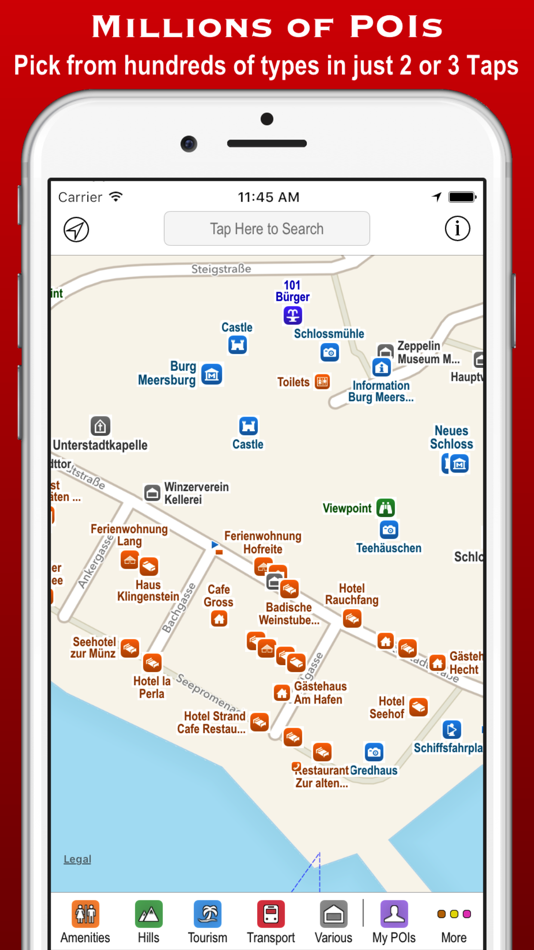
The app contains every possible category of POI: hotels, banks, toilets, tourist attractions, hills, towns, transport, hospitals, churches, schools, libraries, civic buildings, rescue services, fuel stations, restaurants, bars, shops, leisure, parking and much much more.
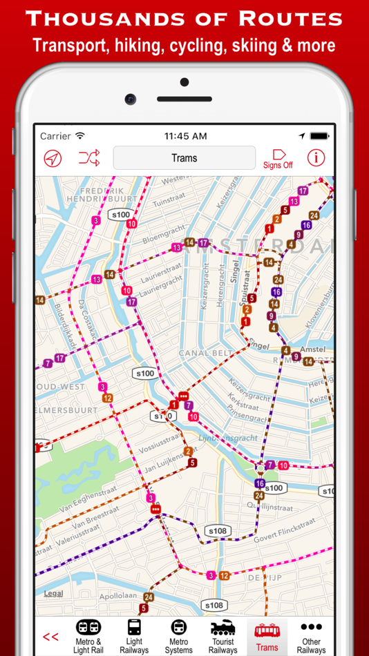
It also contains hundreds of thousands of miles of colour-coded routes, such as railways, subway maps, bus routes, cycle routes, hiking trails and ski pistes. The POIs and routes are all taken from the fantastic OpenStreetMap project.
The app includes many unique features:
• a toolbar at the bottom of the screen that allows you to display what you want in just 2 or 3 taps;
• signs pointing to offscreen POIs, so that you never miss a nearby POI;
• compass, radar and scanner modes that display the nearest POIs in different ways;
• a unique gesture that allows rapid panning by temporarily zooming out (using 3D Touch when available);
• back and forward buttons that help you retrace what you have looked at (like on a browser);
• an Apple Watch app that shows what you want in only a few taps (or just one tap of the complication);
Compass mode simply shows signs to the POIs. This is particularly useful when you just want to know what is around you or which way to head, and you haven’t got time to inspect a map, such as when cycling or hiking. It also works offline and is perfect for people who hate maps: they just follow the sign to where they want to go. It is also great at viewpoints to identify what hills, towns and structures you can see.
Radar mode and Scanner modes are similar but also include a map that rotates around the current position. They include radar “rings” to show the distances from the current position. Scanner mode uniquely positions the GPS dot at the bottom of the screen so that you can see much more information in the direction that you are pointing.
The unique panning gesture requires just one touch of one finger instead of the multi-finger gymnastics required by the traditional “pinch to zoom” approach (although that is still available). It also provides a quick way of zooming out and back in again when you are not sure what area the map is showing. It is a brilliant and completely original use of 3D Touch but also works fine on iPhones without it (using a long touch).
The Apple Watch app also allows you to select any category in just a few taps. When you have selected a category then the nearest POIs are shown on a mini-map with the details listed below. The watch app also provides navigation to a POI, and you can even phone a POI from the watch!
These are just some of the unique aspects of the app. All the usual map features are also provided, such as super-fast searching, directions, bookmarks, POI information, favouriting of brands, and much more. You can even create your own POIs, such as where you parked your car.
Note that this free version includes most of the categories, but the expansion pack is required for POIs and routes in the food & drink, shops, sport & leisure and driving categories.
Ảnh chụp màn hình


Tính năng mới
- Phiên bản: 3.0.8
- Cập nhật:
- Now compatible with iPhone X and Apple Watch 3.
Updated with the latest POIs and routes from OpenStreetMap.
Giá bán
- Hôm nay: Miễn phí
- Tối thiểu: Miễn phí
- Tối đa: Miễn phí
Theo dõi giá
Nhà phát triển
- CCS Ltd
- Nền tảng: iOS Ứng dụng (7)
- Danh sách: 0 + 5
- Điểm: 3 + 1,264 ¡
- Xếp hạng: 0
- Đánh giá: 0
- Giảm giá: 0
- Video: 0
- RSS: Đăng ký
Điểm
Không tìm thấy ☹️
Xếp hạng
Không tìm thấy ☹️
Danh sách
Không tìm thấy ☹️
Đánh giá
Hãy là người đầu tiên đánh giá!
Thông tin bổ sung
- Danh mục:
iOS Ứng dụng›Bản đồ và dẫn đường - HĐH:
Apple Watch,iPad,iPhone,iOS 8.0 trở lên - Kích thước:
153 Mb - Ngôn ngữ được hỗ trợ:
English,French,German,Italian,Spanish - Xếp hạng nội dung:
4+ - App Store Xêp hạng:
5.0(1) - Cập nhật:
- Ngày phát hành:
Bạn cũng có thể thích
-
- 4WD Maps - Offline Topo Maps
- iOS Ứng dụng: Bản đồ và dẫn đường Bởi: Hema Maps
- $64.99
- Danh sách: 0 + 0 Xếp hạng: 0 Đánh giá: 0
- Điểm: 0 + 4 Phiên bản: 2.4.2 Best value Hema App. The one-time cost includes all Hema 4WD maps, without any recurring subscriptions. Use offline mapping and your device s in-built GPS receiver to see where you are
-
- Maps 3D PRO - Hike & Bike
- iOS Ứng dụng: Bản đồ và dẫn đường Bởi: movingworld GmbH
- $3.99
- Danh sách: 1 + 4 Xếp hạng: 0 Đánh giá: 0
- Điểm: 0 + 194 Phiên bản: 6.6 Enjoy exploring the great outdoors? If you re a fan of biking, hiking and running then Maps 3D is the ideal app designed for planning your outdoor adventures. Whereas other mapping ...
-
- Goose Maps for Watch
- iOS Ứng dụng: Bản đồ và dẫn đường Bởi: GOOSE MAPS LTD
- Miễn phí
- Danh sách: 0 + 0 Xếp hạng: 0 Đánh giá: 0
- Điểm: 0 + 181 Phiên bản: 1.3 Features - Navigate easily everywhere Our pedestrian and bike navigation perfectly work even if your iPhone stayed at home. - Search objects you need Our search helps you to find ...
-
- Local Maps
- iOS Ứng dụng: Bản đồ và dẫn đường Bởi: Local Maps Inc
- Miễn phí
- Danh sách: 0 + 0 Xếp hạng: 0 Đánh giá: 0
- Điểm: 0 + 4 Phiên bản: 1.3 Find the funnel cake stand or next horse race faster than ever before with this free and easy to use navigation platform for fairs and festivals. Start enjoying your time by finding ...
-
- Apple Maps
- iOS Ứng dụng: Bản đồ và dẫn đường Bởi: Apple
- Miễn phí
- Danh sách: 3 + 1 Xếp hạng: 4 (1) Đánh giá: 0
- Điểm: 1 + 23,006 Phiên bản: 1.5 Maps Apple Maps is the best way to navigate and explore the world - all with your privacy protected. What s New: Multi-stop routing lets you add multiple stops along your driving route
-
- Google Maps
- iOS Ứng dụng: Bản đồ và dẫn đường Bởi: Google
- Miễn phí
- Danh sách: 13 + 6 Xếp hạng: 5 (3) Đánh giá: 5 (1)
- Điểm: 5 + 5,879,662 Phiên bản: 6.113.0 Navigate your world faster and easier with Google Maps. Over 220 countries and territories mapped and hundreds of millions of businesses and places on the map. Get real-time GPS ...
-
- GPS Route Finder & Voice Maps
- iOS Ứng dụng: Bản đồ và dẫn đường Bởi: Mudassar Ahmed
- Miễn phí
- Danh sách: 0 + 0 Xếp hạng: 0 Đánh giá: 0
- Điểm: 0 + 8 Phiên bản: 9.0 Get Turn by Turn GPS Driving Directions and Best Route to Your Destination with GPS Route Finder & Voice Maps Navigation App! GPS Route Finder & Voice MAPS is an easy to use GPS ...
-
- Wander: Maps & Navigation
- iOS Ứng dụng: Bản đồ và dẫn đường Bởi: Wander App Inc
- Miễn phí
- Danh sách: 0 + 0 Xếp hạng: 0 Đánh giá: 0
- Điểm: 0 + 32 Phiên bản: 5.2.6 Wander is a global network of locally built maps. In the Wander App you'll find premium and official maps for large and small travel and recreation destinations. No more downloading an
-
- Bristol Maps
- iOS Ứng dụng: Bản đồ và dẫn đường Bởi: Chris Hager
- * Miễn phí
- Danh sách: 0 + 0 Xếp hạng: 0 Đánh giá: 0
- Điểm: 0 + 2 Phiên bản: 2.05 Bristol Maps is designed specifically for commercial fishermen to navigate using the latest satellite imagery. Currently serving Bristol Bay and Copper River watersheds. Say goodbye to
-
- Yango Maps
- iOS Ứng dụng: Bản đồ và dẫn đường Bởi: Direct Cursus Computer Systems Trading
- Miễn phí
- Danh sách: 0 + 0 Xếp hạng: 0 Đánh giá: 0
- Điểm: 0 + 102 Phiên bản: 18.0 Navigate the city easily, whether you're driving, walking, or using public transport. With our GPS-powered app, you can see your precise location and get convenient directions straight
-
- Petal Maps – GPS & Navigation
- iOS Ứng dụng: Bản đồ và dẫn đường Bởi: Huawei Software Technologies Co., Ltd.
- Miễn phí
- Danh sách: 0 + 0 Xếp hạng: 0 Đánh giá: 0
- Điểm: 1 + 67 Phiên bản: 1.2.300 A new way to navigate Petal Maps lets you explore the world around you in new ways. Available in over 160 countries and regions, it not only lets you get your current location, browse ...
-
- York U Maps
- iOS Ứng dụng: Bản đồ và dẫn đường Bởi: YAN CHEN
- Miễn phí
- Danh sách: 1 + 0 Xếp hạng: 0 Đánh giá: 0
- Điểm: 1 + 3 Phiên bản: 2.0 York U Maps is a navigation app for Keele campus of York University. You can search for buildings with their abbreviations, e.g. LAS for Lassonde Building, which are commonly used in ...
-
- Forest Maps 2
- iOS Ứng dụng: Bản đồ và dẫn đường Bởi: Kinnaman Software LLC
- Miễn phí
- Danh sách: 0 + 0 Xếp hạng: 0 Đánh giá: 0
- Điểm: 0 + 476 Phiên bản: 2.7.2 Forest service maps on your iPhone or iPad! This app includes all areas mapped by the United States Forest Service. The map is a single, continuous map, so there's no need to search ...
-
- OutDoors GPS France - IGN Maps
- iOS Ứng dụng: Bản đồ và dẫn đường Bởi: RoadTour LLC
- Miễn phí
- Danh sách: 0 + 0 Xếp hạng: 0 Đánh giá: 0
- Điểm: 0 + 32 Phiên bản: 6.5.7 ** France s No1 mapping and GPS app Ideal for following hiking and biking routes in total confidence Official Topo Maps (IGN) can be downloaded so app works anywhere regardless of ...
Bạn cũng có thể thích
- iOS Ứng dụng
- Mới iOS Ứng dụng
- Bản đồ và dẫn đường iOS Ứng dụng : Mới
- Video iOS Ứng dụng
- Phổ biến iOS Ứng dụng
- Bản đồ và dẫn đường iOS Ứng dụng : Phổ biến
- Giảm giá iOS Ứng dụng
- Bản đồ và dẫn đường iOS Ứng dụng : Giảm giá
- Xếp hạng iOS Ứng dụng
- Đánh giá iOS Ứng dụng
- Danh sách iOS Ứng dụng
- Điểm iOS Ứng dụng