| Nhà phát triển: | GrangerFX (11) | ||
| Giá bán: | Miễn phí | ||
| Xếp hạng: | 0 | ||
| Đánh giá: | 0 Viết đánh giá | ||
| Danh sách: | 0 + 0 | ||
| Điểm: | 0 + 3 (4.7) ¡ | ||
| App Store | |||
Mô tả
")
To get started, tap the arrow button in the toolbar to begin GPS tracking and center the map at your current location. The spinner in the status bar shows that the map is being loaded. The spinner stops when the map is fully cached at that location. You can scroll around the map or tilt the map with a two finger vertical swipe to see it in 3D.
Use the two finger vertical swipe gesture to tilt the map for a 3D view. Scroll like a map or fly like a flight simulator. Enable Joystick Gestures in the Settings menu and then fly around the terrain using a virtual joystick. Prefer only 2D maps? Enable the 2D Map option in the Settings menu.
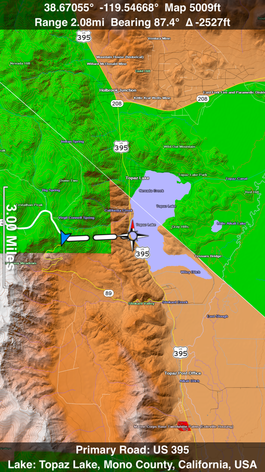
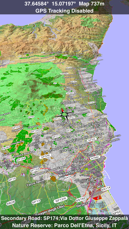
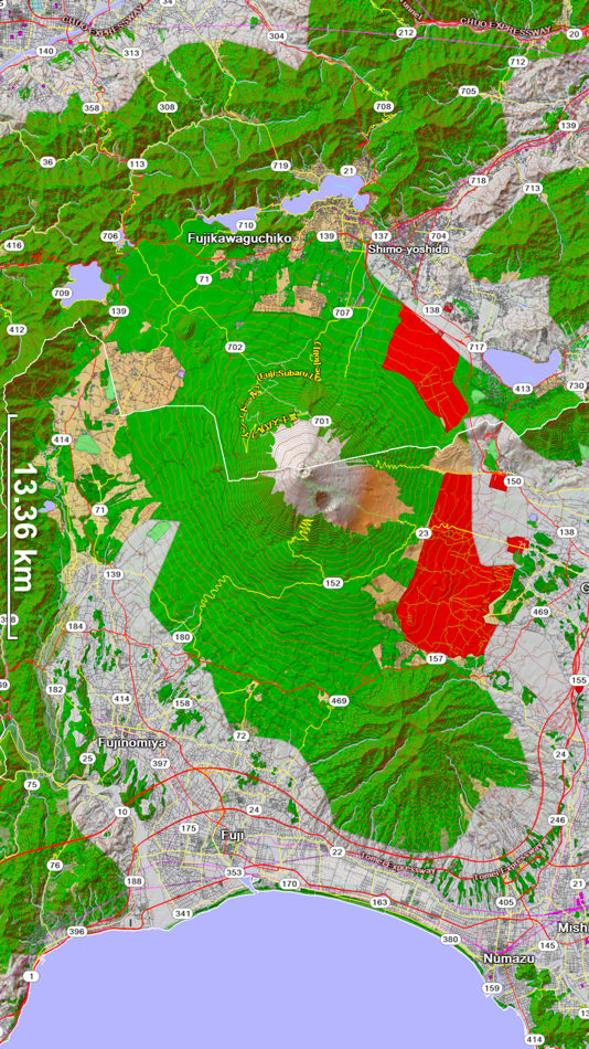
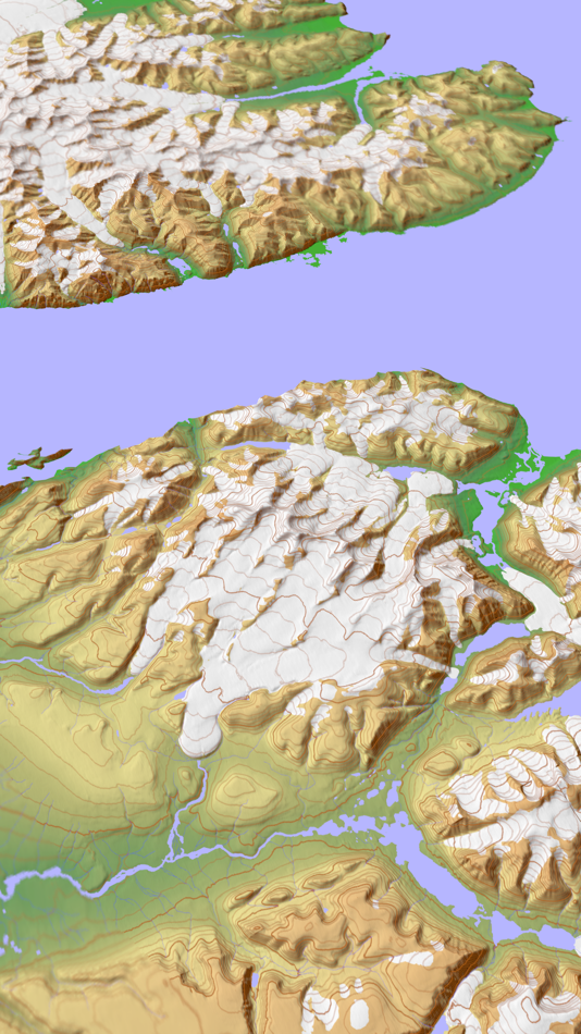
Scenic Map is simply the best 3D topo map available for a mobile device. You will see incredible detail while scrolling, rotating and zooming perfectly smoothly. You will see every road even if you zoom out to the altitude of a satellite. As you zoom in, you will see every small bump and hollow of the Earth and terrain features as small as ten meters. Unlike old fashioned topo maps, Scenic Map’s roads and trails are up to date thanks to OpenStreetMap.org. It contains polygons for urban areas, shopping malls, an ever growing number of buildings and many other features, The best lake, pond, stream and rivers from the USGS and Canadian public databases are also included.
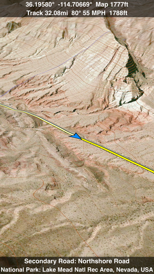
Your tracks can be replayed with video like controls to speed up, slow down, pause, restart or skip to the end. You can display existing tracks while recording another if you want to retrace your route. When online, you can automatically create a route from your current GPS location to any other point on the map. Tracks can be received from or sent to other apps in GPX format. GPS recording stops automatically after you have remained stationary for some time or you can choose to manually stop tracking by tapping on the top track in the Tracks view.
Never before have maps been this customizable. For example, you can turn on or off the roads. You can change the lighting direction or remove terrain shading entirely. You can display contour lines even over satellite images. There are five presets which let you quickly switch between map styles. Use Metric, English or Nautical units and choose one of four different coordinate displays including UTM.
Want to learn more about a map feature? Tap the target icon and center the feature under the compass rose to display its name, type, urban area, county, state, elevation and coordinates. You will also see a bearing line back to your current GPS location or from your location to a selected waypoint. The status bar shows the bearing direction and distance along with the map and GPS elevation, the track length, and your current speed and direction of travel.
In-app documentation is provided in the Help section at the top of the Settings menu. Links are provided in the documentation to detailed coverage maps, tutorial videos, installation guide and blog at ScenicMap.com
Map data © OpenStreetMap and contributors under the Open Database License
Scenic Map supports GPS tracking while the app is in the background.
Caution: Continued use of GPS running in the background can dramatically decrease battery life.
Ảnh chụp màn hình
Tính năng mới
- Phiên bản: 1.9.2
- Cập nhật:
- All features are now unlocked for free.
Fixed track recording in iOS 17.
Fixed the settings menu in landscape mode on iPhone.
Fixed low frame rate when the information bar is enabled.
The map's highest detail is now displayed while scrolling.
Giá bán
- Hôm nay: Miễn phí
- Tối thiểu: Miễn phí
- Tối đa: Miễn phí
Theo dõi giá
Nhà phát triển
- GrangerFX
- Nền tảng: iOS Ứng dụng (11)
- Danh sách: 1 + 0
- Điểm: 1 + 928 ¡
- Xếp hạng: 0
- Đánh giá: 0
- Giảm giá: 0
- Video: 0
- RSS: Đăng ký
Điểm
0 ☹️
Xếp hạng
0 ☹️
Danh sách
0 ☹️
Đánh giá
Hãy là người đầu tiên đánh giá 🌟
Thông tin bổ sung
- Phiên bản: 1.9.2
- Danh mục:
iOS Ứng dụng›Bản đồ và dẫn đường - HĐH:
iPad,iPhone,iOS 16.1 trở lên - Kích thước:
66 Mb - Ngôn ngữ được hỗ trợ:
English - Xếp hạng nội dung:
4+ - App Store Xêp hạng:
4.7(3) - Cập nhật:
- Ngày phát hành:
Danh bạ
- Trang web:
 http://scenicmap.blogspot.com
- 🌟 Chia sẻ
- App Store
Bạn cũng có thể thích
-
- Scenic Map Grand Canyon
- iOS Ứng dụng: Bản đồ và dẫn đường Bởi: GrangerFX
- Miễn phí
- Danh sách: 0 + 0 Xếp hạng: 0 Đánh giá: 0
- Điểm: 1 + 2 (5.0) Phiên bản: 1.9.2 Explore the rich landscapes around the Grand Canyon and Arizona while you discover Scenic Map, the best 3D topo map for the iPad and iPhone. The vector map data is contained within the ⥯
-
- MineAR: Augmented Reality Map
- iOS Ứng dụng: Bản đồ và dẫn đường Bởi: Map Life, LLC
- * Miễn phí
- Danh sách: 0 + 0 Xếp hạng: 0 Đánh giá: 0
- Điểm: 0 + 5 (5.0) Phiên bản: 2.40.15 Data you can grasp. As a geoscience professional, we know you want an easier way to see your GIS data while you re in the field. MineAR allows you to do exactly that. Our app ... ⥯
-
- Map LT
- iOS Ứng dụng: Bản đồ và dẫn đường Bởi: Taylan Atasoy
- Miễn phí
- Danh sách: 0 + 0 Xếp hạng: 0 Đánh giá: 0
- Điểm: 0 + 0 Phiên bản: 4.0 Map LT is a cutting-edge navigation and mapping application designed for users who want to easily find their way around World. With its user-friendly interface and comprehensive ... ⥯
-
- Scenic Motorcycle Navigation
- iOS Ứng dụng: Bản đồ và dẫn đường Bởi: Applified Life Ltd.
- * Miễn phí
- Danh sách: 0 + 0 Xếp hạng: 0 Đánh giá: 0
- Điểm: 2 + 7,096 (4.7) Phiên bản: 4.27 TAKE THE SCENIC ROUTE - Plan, ride, track and share your adventures with the #1 rated motorbike navigation app. 200,000 public routes, 20 million hours ridden, 130 million miles ... ⥯
-
- Map Map - Your Map on a Map
- iOS Ứng dụng: Bản đồ và dẫn đường Bởi: Ben Roberts
- * Miễn phí
- Danh sách: 0 + 0 Xếp hạng: 0 Đánh giá: 0
- Điểm: 0 + 2 (5.0) Phiên bản: 2.3 Welcome to Map Map Your Personal Cartographer! Ever wished you could see where you were on a trail map, building diagram, or any other visual reference? How about knowing where a trail ⥯
-
- Memory-Map for All
- iOS Ứng dụng: Bản đồ và dẫn đường Bởi: Memory-Map
- Miễn phí
- Danh sách: 0 + 0 Xếp hạng: 0 Đánh giá: 0
- Điểm: 0 + 9 (4.9) Phiên bản: 2.0.5 Download maps for Offline GPS Navigation. No mobile data connection required. Your favorite maps and charts from OS, Hema, NOAA, and many more. Immersive 3D World map view Fully ... ⥯
-
- Map MateAI- Navigate with Chat
- iOS Ứng dụng: Bản đồ và dẫn đường Bởi: Ahmet Erkin Arıkan
- Miễn phí
- Danh sách: 0 + 0 Xếp hạng: 0 Đánh giá: 0
- Điểm: 0 + 0 Phiên bản: 1.0.3 Struggling to decide where to go? Let our app guide you! Whether you're searching for a cozy café, an exciting spot to explore, or a pharmacy on duty, we ve got you covered. Simply ... ⥯
-
- Map Tells...!
- iOS Ứng dụng: Bản đồ và dẫn đường Bởi: Yuriko Kimura
- Miễn phí
- Danh sách: 0 + 0 Xếp hạng: 0 Đánh giá: 0
- Điểm: 0 + 0 Phiên bản: 3.4 "Map Tells...! is an app that shares your location with your companion by providing a Google Maps link and photo. The mail receiver follows the directions (on the map or through a ... ⥯
-
- Map It Realtour
- iOS Ứng dụng: Bản đồ và dẫn đường Bởi: DKP Productions LLC
- Miễn phí
- Danh sách: 0 + 0 Xếp hạng: 0 Đánh giá: 0
- Điểm: 0 + 3 (5.0) Phiên bản: 2.0.2 Map It Realtour® / Mobile Application for Realtors With New Map It Client Version for Their Clients Map It Realtour® is a new and unique Real Estate App for Agents worldwide, that was ... ⥯
-
- Map Tools
- iOS Ứng dụng: Bản đồ và dẫn đường Bởi: Modular Machines LLC
- $1.99
- Danh sách: 0 + 0 Xếp hạng: 0 Đánh giá: 0
- Điểm: 0 + 1 (5.0) Phiên bản: 6.1 Map Tools supports coordinate systems and map projections for 232 datums, including WGS84, NAD27, NAD83, ED50, OSGB36, EGSA87, AGD66, AGD84, GDA94, NZGD2000, NZGD1949, and many more. ... ⥯
-
- Map Points
- iOS Ứng dụng: Bản đồ và dẫn đường Bởi: Sachin Deshpande
- $0.99
- Danh sách: 0 + 0 Xếp hạng: 0 Đánh giá: 0
- Điểm: 0 + 0 Phiên bản: 1.2 Map Points is an app to store your favorite map locations. You can use it while hiking to mark pinpoint locations that you want to remember. Or you can drop a pin to mark the secret ... ⥯
-
- Map-in
- iOS Ứng dụng: Bản đồ và dẫn đường Bởi: Uchechukwu Debra Ginigeme
- Miễn phí
- Danh sách: 0 + 0 Xếp hạng: 0 Đánh giá: 0
- Điểm: 0 + 4 (5.0) Phiên bản: 10.0.0 Design interior maps of large spaces like malls, schools and hospitals. Navigate large indoor spaces with ease. Find items fast. At Map-In, we are revolutionizing the way people ... ⥯
-
- Map Snapper
- iOS Ứng dụng: Bản đồ và dẫn đường Bởi: Mark Malone
- * Miễn phí
- Danh sách: 0 + 0 Xếp hạng: 0 Đánh giá: 0
- Điểm: 0 + 0 Phiên bản: 2.1 Plan orienteering events by placing and fine tuning control locations in the field. Create your own instant offline maps. Create geolocated maps from photos and pictures, either with ... ⥯
-
- Map Link Converter
- iOS Ứng dụng: Bản đồ và dẫn đường Bởi: POORNA S JAYASINGHE
- $4.99
- Danh sách: 0 + 0 Xếp hạng: 0 Đánh giá: 0
- Điểm: 0 + 0 Phiên bản: 1.0 Seamlessly open any map link in your preferred navigation app. Map Link Converter is the ultimate tool for converting and opening map URLs across different mapping platforms. Whether ... ⥯