| Utvikler: | SKYDREAMSOFT OOD (1) | ||
| Pris: | Gratis | ||
| Rangeringer: | 0 | ||
| Anmeldelser: | 0 Skrive en omtale | ||
| Lister: | 0 + 0 | ||
| Poeng: | 0 + 1 (4.0) ¡ | ||
| App Store | |||
Beskrivelse
")
Listes des fonctionnalités :
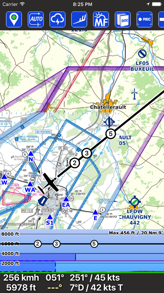
- Tracking GPS de l'appareil : Position, vitesse sol, cap, altitude
- Vecteur vitesse avec bulles ou tirets de temps
- Gestion du point de navigation courant (cap à prendre / temps restant)
- Affichage au choix du vent & dérive, de la hauteur, ou de l'heure d'arrivée à destination
- Auto-centrage intelligent de la carte
- Modes nord-vrai ou direction de l'appareil
- Fonction rapide de "Direct"
- La fonction "Direct" permet de rechercher des villes, villages (si connecté)
- Enregistrement automatique des traces de vos vols (visualisation directement dans SDVFR ou export aux formats KML ou GPX)
- Embarquer facilement toute la documentation du SIA (VAC, VAC HELI, AIP, SUP AIP, AZBA)
- Accès facile aux guides VFR & météo, complément aux cartes, légendes
- VAC géo-référencées plaquées sur le fond de carte (approche, tour de piste, taxiways & parkings)
- SUP AIP géo-référencés (voir les zones issues des SUP AIP directement sur la carte)
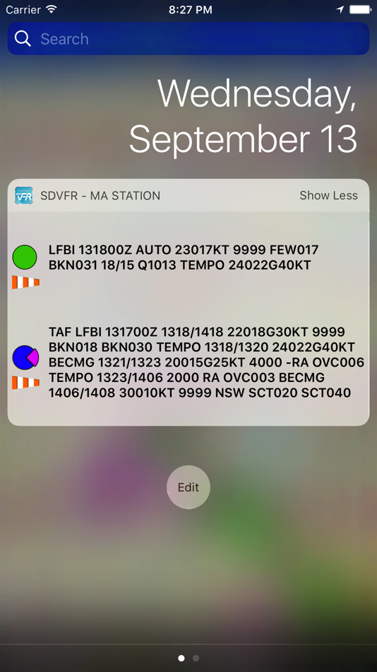
- Messages météo : METAR, TAF, SIGMET (décodage, couleurs, alerte vent, sigmets graphiques, synthèse vocale)
- Widget "Ma station" pour visualiser rapidement vos METAR & TAF préférés sans lancer l'application
- Position et informations des aéroports / aérodromes / hélistations / bases ULM (http://basulm.ffplum.info)
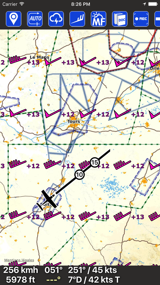
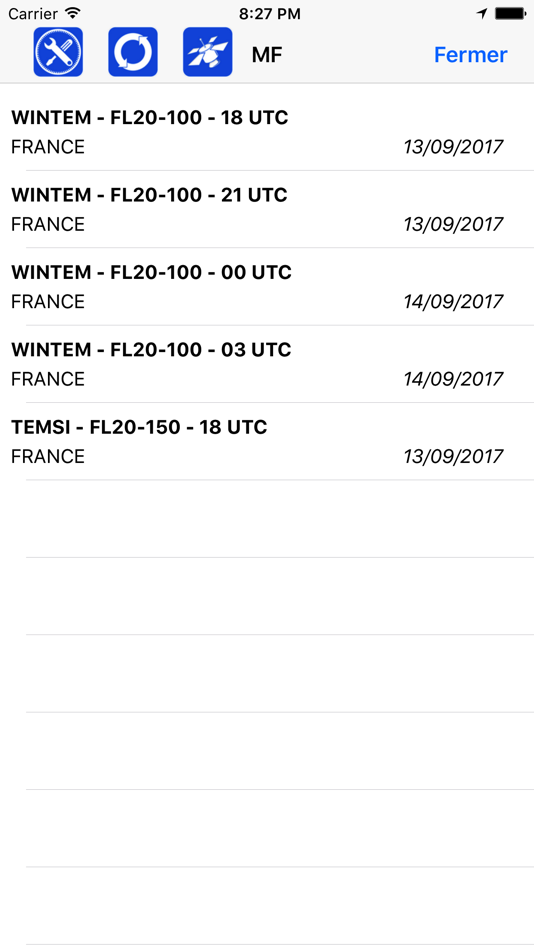
- Visualiser les wintems sur 18 niveaux différents (FL005 au FL150) sur 24 heures de prévisions
- Accès direct aux cartes Météo-France (Wintem & Temsi)
- Cartes aéronautiques : IGN 500K, SIA 250K, CartaBossy, Editerra Air Million (payantes)
- Carte aéronautique SDOACI France & Corse (gratuite)
- Cartes SIA million & croisières, OpenStreetMap, IGN Scan routier 1M/250K routier (gratuites)
- Option payante pour utiliser vos propres cartes (format mbtiles)
- Synchronisation automatique des avions, navigations et cartes entre vos terminaux
- Synchronisation à la demande des traces de vos vols
- Notams d'aérodromes et de FIR
- Fonction AZBA dynamiques
- Points de reports VFR
- Profil dynamique (vue en coupe des espaces aériens devant vous)
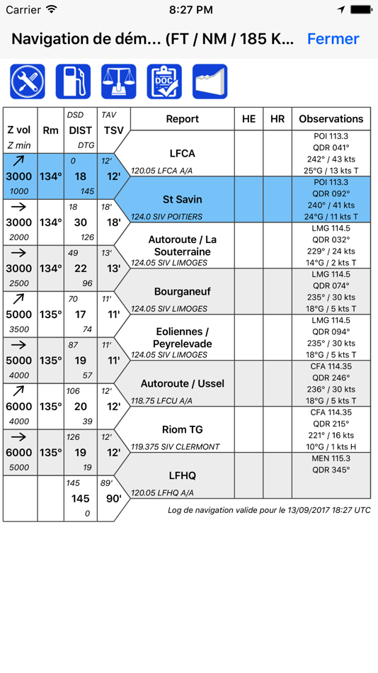
- Construire facilement une navigation et voir le log de nav correspondant
- Associer des fréquences sur son log de navigation
- Calcul automatique de la dérive et du vent effectif, temps avec vent
- Calcul théorique des montées / descentes
- Gérer une liste d'appareils avec leurs caractéristiques
- Ecran "Dossier de vol" : Terrains, Notams, METAR, TAF sur votre route
- Profil de la navigation complète (relief & espaces aériens traversés)
- Visualiser un espace aérien et ses informations facilement via un double-tap sur la carte
- Gérer vos navigations (exportation PDF, sauvegarde, impression, envoi par email)
- Import/Export de navigations ou de traces au format GPX
- Export de navigations au format PLN pour FSX ou P3D
- Export de navigations au format FPL pour Garmin
- Editer des devis carburant (exportation PDF, impression, envoi par email)
- Ecran de masses et centrage
- Unités modifiables (altitude, distance, vitesse)
- Personnalisation des épaisseurs et couleurs de trait (navigation, vecteur vitesse, trace)
- Recoupements VOR / NDB
- Gestion de points personnalisés (UserWaypoints)
- Afficher des fichiers KML sur la carte
- Deux chronomètres
- Déclinaison magnétique prise en compte
- Application pensée pour l'utilisation non-connectée
- Utilise des données officielles issues du SIA
- Mise à jour automatique (Cycle AIRAC tous les 28 jours)
- Connexion à un simulateur (FS2020, FSX, P3D, X-Plane, FlightGear, AeroFly)
- Connexion à un boitier de détection de trafics (GDL90 via Wifi)
- Système de "notams" pour être informer sur l'état de santé de l'application
- Stocker des fichiers PDF personnels dans l'explorateur de documents
Skjermbilder
Pris
- I dag: Gratis
- Minimum: Gratis
- Maksimalt: Gratis
Spor priser
Utvikler
- SKYDREAMSOFT OOD
- Plattformer: iOS Apper (1)
- Lister: 0 + 0
- Poeng: 0 + 1 ¡
- Rangeringer: 0
- Anmeldelser: 0
- Rabatter: 0
- Videoer: 0
- RSS: Abonner
Poeng
0 ☹️
Rangeringer
0 ☹️
Lister
0 ☹️
Anmeldelser
Bli den første til å vurdere 🌟
Tilleggsinformasjon
- Versjon: 1.983
- Kategori:
iOS Apper›Navigering - OS:
iPad,iPhone,iOS 13.0 og nyere - Størrelse:
23 Mb - Språk som støttes:
French - Egnethet:
4+ - App Store Vurdering:
4.0(1) - Oppdatert:
- Utgivelsesdato:
Kontakter
- Nettsted:
 https://skydreamsoft.fr
- 🌟 Dele
- App Store
Du vil kanskje også like
-
- Google Maps
- iOS Apper: Navigering Av: Google
- Gratis
- Lister: 14 + 9 Rangeringer: 5 (3) Anmeldelser: 5 (1)
- Poeng: 5 + 6,943,974 (4.7) Versjon: 25.45.1 Explore and navigate the world with confidence using Google Maps. Find the best routes with live traffic data and real-time GPS navigation for driving, walking, cycling, and public ... ⥯
-
- Waze Navigation & Live Traffic
- iOS Apper: Navigering Av: Waze Inc.
- Gratis
- Lister: 9 + 4 Rangeringer: 5 (1) Anmeldelser: 0
- Poeng: 1 + 3,101,757 (4.8) Versjon: 5.13.0.2 Know what's ahead on the road with the help from other drivers. Waze is a live map that harnesses the local knowledge of tens of millions of drivers around the world. Drivers safely ... ⥯
-
- Transit • Subway & Bus Times
- iOS Apper: Navigering Av: Transit App, Inc.
- Gratis
- Lister: 3 + 0 Rangeringer: 0 Anmeldelser: 0
- Poeng: 0 + 835,013 (4.6) Versjon: 6.0.9 Transit is your real-time urban travel companion. Open the app to instantly see accurate next departure times, track buses and trains near you on the map, and see upcoming transit ... ⥯
-
- SpotHero: #1 Rated Parking App
- iOS Apper: Navigering Av: SpotHero, Inc.
- Gratis
- Lister: 0 + 0 Rangeringer: 0 Anmeldelser: 0
- Poeng: 0 + 352,250 (4.8) Versjon: 8.0.0 Park smarter with the SpotHero iPhone app. SpotHero helps you get everywhere, easier by making it fast and convenient to find and reserve parking in major cities. Plus, when you book ... ⥯
-
- onX Hunt: GPS Hunting Maps
- iOS Apper: Navigering Av: onXmaps, Inc.
- Gratis
- Lister: 0 + 0 Rangeringer: 0 Anmeldelser: 0
- Poeng: 1 + 257,396 (4.9) Versjon: 25.43.0 Navigate your next hunt and view species distribution, topo maps, hunting units, and more. Whether you re a private or public land hunter, know where you stand with land ownership ... ⥯
-
- MTA TrainTime
- iOS Apper: Navigering Av: Metropolitan Transportation Authority
- Gratis
- Lister: 0 + 0 Rangeringer: 0 Anmeldelser: 0
- Poeng: 0 + 207,392 (4.9) Versjon: 9.13.3 The TrainTime app provides a one-stop shop for Long Island Rail Road and Metro-North Railroad customers, where riders can buy and use tickets, plan their trips, track their trains, and ⥯
-
- ParkWhiz - #1 Parking App
- iOS Apper: Navigering Av: ParkWhiz, Inc.
- Gratis
- Lister: 0 + 0 Rangeringer: 0 Anmeldelser: 0
- Poeng: 0 + 187,391 (4.8) Versjon: 11.3.2 Take the hassle out of parking with the ParkWhiz app. Find parking in any major city, compare prices, plus save up to 50% when you book in advance. Free yourself from parking hassles ... ⥯
-
- Exxon Mobil Rewards+
- iOS Apper: Navigering Av: Exxon Mobil Corporation
- Gratis
- Lister: 0 + 0 Rangeringer: 0 Anmeldelser: 0
- Poeng: 0 + 185,852 (4.8) Versjon: 6.5.2 Go on. Fuel Up. Earn More. Pay Less. The Exxon Mobil Rewards+ app is your secure, contactless way to pay at the pump or in-store while earning valuable rewards points every time you ... ⥯
-
- PlugShare: Charging Stations
- iOS Apper: Navigering Av: Recargo, Inc.
- Gratis
- Lister: 0 + 0 Rangeringer: 0 Anmeldelser: 0
- Poeng: 0 + 131,059 (4.7) Versjon: 7.30.0 Download the most accurate EV and Tesla charging station map. PlugShare is the world s largest EV driver community. Drivers contribute station reviews and photos to help the EV ... ⥯
-
- Trucker Path: Truck GPS & Map
- iOS Apper: Navigering Av: Trucker Path Inc.
- Gratis
- Lister: 1 + 0 Rangeringer: 0 Anmeldelser: 0
- Poeng: 0 + 124,972 (4.8) Versjon: 6.8.2 North America s most popular app for Truckers. BUILT FOR TRUCKERS, BY TRUCKERS! Get all trucker tools in one FREE APP! Best Trucking APP featured by truckers! Trucker Path is a mapping ⥯
-
- Avenza Maps: Offline Mapping
- iOS Apper: Navigering Av: Avenza Systems Inc.
- Gratis
- Lister: 0 + 1 Rangeringer: 0 Anmeldelser: 0
- Poeng: 0 + 122,542 (4.8) Versjon: 262 Avenza Maps, #1 app for hiking, biking and all trails. Featuring maps from National Geographic, national parks and more! On your next adventure, stay on track with GPS using offline ... ⥯
-
- New York Subway MTA Map NYC
- iOS Apper: Navigering Av: Mapway Limited
- Gratis
- Lister: 0 + 0 Rangeringer: 0 Anmeldelser: 0
- Poeng: 0 + 107,702 (4.6) Versjon: 5.5.6 New York Subway uses the official MTA subway map and includes a helpful transit route planner. With over 12 million downloads worldwide this NYC subway map is free to download and will ⥯
-
- Speedometer Simple
- iOS Apper: Navigering Av: WATT APPS
- Gratis
- Lister: 0 + 0 Rangeringer: 0 Anmeldelser: 0
- Poeng: 0 + 101,451 (4.7) Versjon: 2025.9.1 Speedometer Simple is a simple speedometer that is very easy to use. This app uses phone's GPS to accurately determine your speed. Speedometer has large fonts and supports mph, km/h, ... ⥯
-
- Citymapper: All Live Transit
- iOS Apper: Navigering Av: Citymapper Limited
- Gratis
- Lister: 0 + 3 Rangeringer: 0 Anmeldelser: 0
- Poeng: 1 + 96,437 (4.9) Versjon: 11.36.3 Instantly compare your travel options in real-time across all transport modes globally! Easily navigate your city with turn-by-turn directions for all your public transportation, ... ⥯