| Nhà phát triển: | Pocket Mariner Ltd. (12) | ||
| Giá bán: | Miễn phí | ||
| Xếp hạng: | 0 | ||
| Đánh giá: | 0 Viết đánh giá | ||
| Danh sách: | 0 + 0 | ||
| Điểm: | 0 + 230 (4.4) ¡ | ||
Mô tả
")
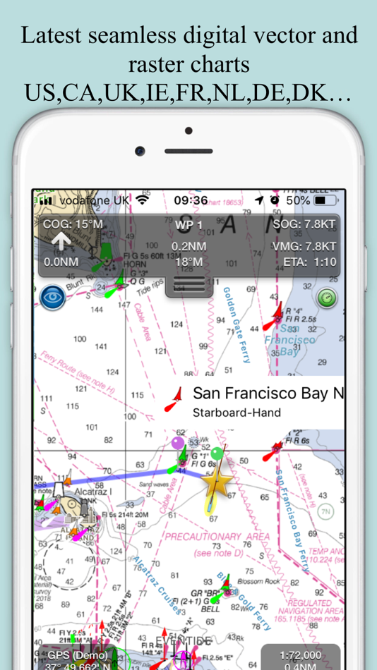
- Vector charts - all buoys, lights etc. are tappable
- Seamless fast panning and zoom across charts
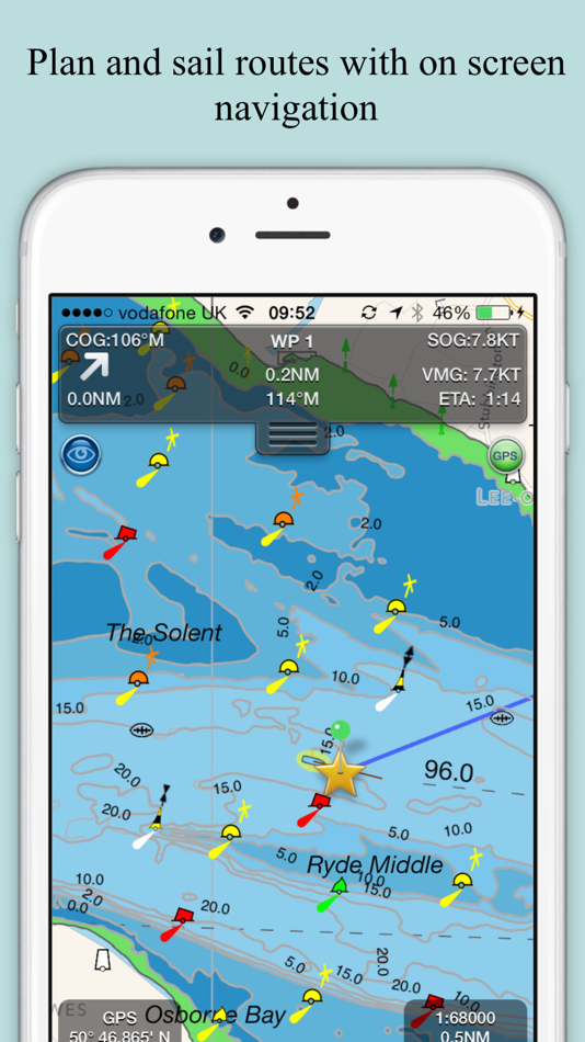
- Route Planning and real-time tracking
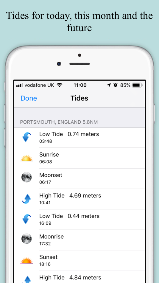
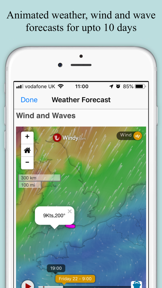
- Tides, Streams & Weather
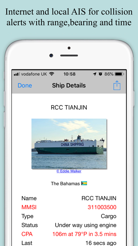
- Live AIS Ship positions and collision alarm (IAP)
- Built-in tutorial mode with free access to all features including charts, AIS, AR & wind
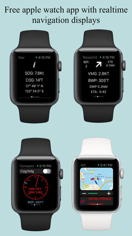
- Includes free Apple Watch app with Nav, Waypoint, Wind, AIS faces.
- Offline charts
- North up and course up displays
- Configurable layers
- Import and share routes and POIs in GPX and KML formats via email and Dropbox
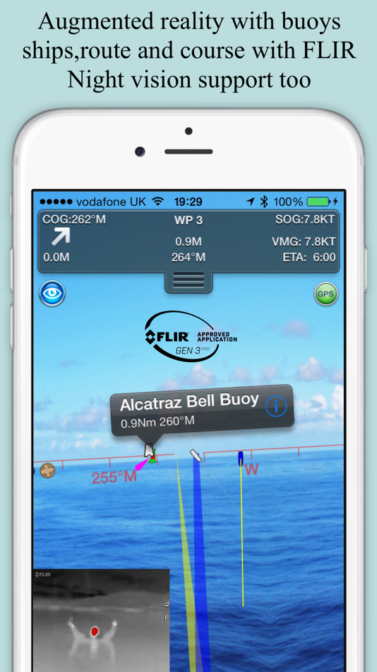
- Live Augmented Reality camera view (IAP) plus FLIRONE® night vision support.
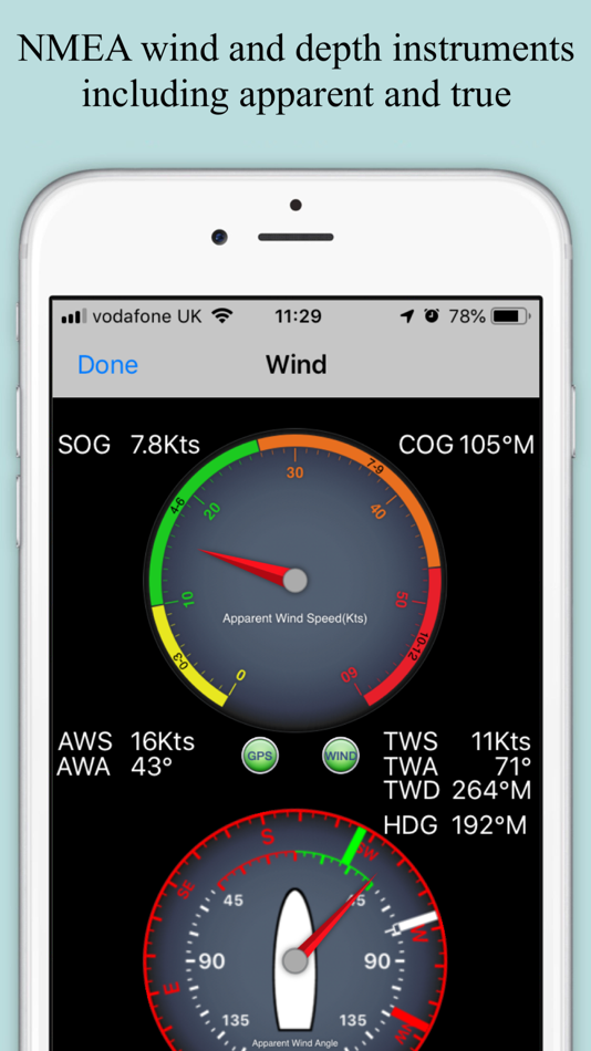
- NMEA Depth, Wind Speed and Direction
- Real time local wind feed (IAP)
The free version includes all navigation and trip planning tools. High resolution vector charts are available by In App Purchase (IAP) including updates for 12 months.
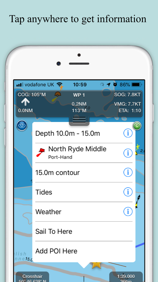
Vector charts provide many advantages over traditional raster charts. Buoys, Lights, Bridges, Depth Contours, Depth Soundings, Rocks, Anchorage areas, NOAA Weather Buoys etc. are all selectable and have real time distance, bearing and detail information. Turn off layers to de-clutter the display and only show what is important at the time. Tides, moon and sun times and weather are also all available at your fingertips.
In-app tools let you measure distances and bearings and record waypoints on routes to sail. When you are out at sea, the app’s Sailing HUD shows your position on the route, Course over ground (COG), Speed over ground (SOG), Vector Made Good (VMG), Estimated Time of Arrival (ETA), Distance and bearing to next Waypoint. Waypoint reached alerts, auto-routing to the next waypoint and flashing collision alerts (with AIS).
Unique AR view mode (IAP) allows you to view buoys, lights, ships, waypoints, route and track overlaid on your iPhone or iPad live camera view. With "AR LockOn" you can select a target on the chart and then be guided to it in the AR camera view. You can also see at night and in the fog with the FLIRONE Infra-red camera.
External NMEA GPS, AIS and Wind data over Wifi.
Requirements:
GPS only required for real time route navigation. Optional Real time AIS, Tides and Weather information require an active internet connection.
WiFi-only iPad or iPods will need an external GPS receiver for navigation.
Please note that continued use of GPS running in the background can dramatically decrease battery life.
Subscriptions
Our in-app purchases are 1 year subscriptions, which automatically renew at the end of the subscription period unless auto-renew is turned off at least 24-hours before the end of the current period. Payment will be charged to your iTunes Account at confirmation of purchase, and will be charged for renewal within 24-hours prior to the end of the current period.
Subscriptions may be managed by the iTunes account holder and auto-renewal may be turned off by going to Account Settings after purchase. No cancellation of the current subscription is allowed during active subscription period.
NOTICES: This product has been derived in part from material obtained from the UK Hydrographic Office with the permission of the UK Hydrographic Office, Her Majesty’s Stationery Office.” “© British Crown Copyright, [2012]. All rights reserved.
The UK Hydrographic Office (UKHO) and its licensors make no warranties or representations, express or implied, with respect to this product. The UKHO and its licensors have not verified the information within this product or quality assured it.
Terms of Use: http://seanav.net/termsofuse.php
Privacy Policy: http://seanav.net/privacy.php
Support: help@pocketmariner.com
Ảnh chụp màn hình

Giá bán
- Hôm nay: Miễn phí
- Tối thiểu: Miễn phí
- Tối đa: Miễn phí
Theo dõi giá
Nhà phát triển
- Pocket Mariner Ltd.
- Nền tảng: iOS Ứng dụng (8) macOS Ứng dụng (4)
- Danh sách: 1 + 0
- Điểm: 3 + 4,635 ¡
- Xếp hạng: 0
- Đánh giá: 0
- Giảm giá: 0
- Video: 0
- RSS: Đăng ký
Điểm
0 ☹️
Xếp hạng
0 ☹️
Danh sách
0 ☹️
Đánh giá
Hãy là người đầu tiên đánh giá 🌟
Thông tin bổ sung
- Phiên bản: 5.4.20
- Danh mục:
iOS Ứng dụng›Bản đồ và dẫn đường - HĐH:
Apple Watch,iPad,iPhone,iOS 15.6 trở lên - Kích thước:
75 Mb - Ngôn ngữ được hỗ trợ:
Danish,English,French,German,Italian,Spanish,Swedish - Xếp hạng nội dung:
4+ - App Store Xêp hạng:
4.4(230) - Cập nhật:
- Ngày phát hành:
Danh bạ
- Trang web:
 http://pocketmariner.com
- 🌟 Chia sẻ
- App Store
Bạn cũng có thể thích
-
- SEA.AI
- iOS Ứng dụng: Bản đồ và dẫn đường Bởi: SEA.AI SAS
- Miễn phí
- Danh sách: 0 + 0 Xếp hạng: 0 Đánh giá: 0
- Điểm: 0 + 0 Phiên bản: 2.3 Increase your vigilance and improve your safety at sea with the SEA.AI application, the user interface of the first marine optical system based on artificial vision. SEA.AI increases ... ⥯
- mới
- Sea Maps
- iOS Ứng dụng: Bản đồ và dẫn đường Bởi: APP ASPIRES
- * Miễn phí
- Danh sách: 0 + 0 Xếp hạng: 0 Đánh giá: 0
- Điểm: 1 + 0 Phiên bản: 1.03 Sea Maps is a marine navigation and weather app designed for boaters, anglers, and ocean explorers. Enjoy a free trial, then continue with a paid subscription to access all core ... ⥯
-
- Nav Tools - Flight and Sail
- iOS Ứng dụng: Bản đồ và dẫn đường Bởi: NAVSTEP LLC
- $3.99
- Danh sách: 0 + 0 Xếp hạng: 0 Đánh giá: 0
- Điểm: 7 + 0 Phiên bản: 1.1.0 The Nav Tools app is a mobile navigation toolbox for air and watercrafts which is always at hand on your iPhone. It uses full power of device s internal sensors data (gyroscope, ... ⥯
-
- Nav Camera
- iOS Ứng dụng: Bản đồ và dẫn đường Bởi: Craig Hunter
- $3.99
- Danh sách: 0 + 0 Xếp hạng: 0 Đánh giá: 0
- Điểm: 0 + 34 (4.0) Phiên bản: 1.2.3 Nav Camera uses the proven navigation, augmented reality, and image processing engines from the well known Theodolite app to create a new app that focuses on photogaphy and video ... ⥯
-
- Nav Trainer Pro
- iOS Ứng dụng: Bản đồ và dẫn đường Bởi: FLEMINGER MEDIA LLC
- $8.99
- Danh sách: 0 + 0 Xếp hạng: 0 Đánh giá: 0
- Điểm: 0 + 37 (3.9) Phiên bản: 3.5.0 Selected by AOPA.org readers as number one of five aviation apps you can't live without! * Reached No. 4 in the Navigation category of the U.S. app store for iPad! Make IFR flight ... ⥯
-
- Nav GC
- iOS Ứng dụng: Bản đồ và dẫn đường Bởi: domesticusdevelop
- $0.99
- Danh sách: 0 + 0 Xếp hạng: 0 Đánh giá: 0
- Điểm: 0 + 1 (1.0) Phiên bản: 2.3 Great circle navigation. -Calculate distance and heading along the great circle between two positions. -Put in speed and get the time to travel. -Use GPS for start position or own ... ⥯
-
- Nav Tools
- iOS Ứng dụng: Bản đồ và dẫn đường Bởi: Jean-Christoph KAISER
- $0.99
- Danh sách: 0 + 0 Xếp hạng: 0 Đánh giá: 0
- Điểm: 0 + 0 Phiên bản: 1.4 A compass combining the accuracy of a numerical display with the easy to read ball. Works with any device orientation making it suitable in both calm and rough see. Point to a target ... ⥯
-
- Nav Diag
- iOS Ứng dụng: Bản đồ và dẫn đường Bởi: Alastair Bor
- Miễn phí
- Danh sách: 0 + 0 Xếp hạng: 0 Đánh giá: 0
- Điểm: 0 + 0 Phiên bản: 1.0 NavDiags is a comprehensive location and navigation diagnostics application for iOS developers, location-based service professionals, and tech enthusiasts needing detailed insights ... ⥯
-
- Sea Pro Connect
- iOS Ứng dụng: Bản đồ và dẫn đường Bởi: John Crawford
- Miễn phí
- Danh sách: 0 + 0 Xếp hạng: 0 Đánh giá: 0
- Điểm: 0 + 0 Phiên bản: 2.0.5 SeaPro GPS tracker allows clients to remotely monitor vital information on their boat and GPS track both in real time and also with historical playback ⥯
-
- RT-Nav
- iOS Ứng dụng: Bản đồ và dẫn đường Bởi: Hilton's Fishing Charts, L.L.C.
- Miễn phí
- Danh sách: 0 + 0 Xếp hạng: 0 Đánh giá: 0
- Điểm: 0 + 8 (3.0) Phiên bản: 1.178 Hilton's Realtime-Navigator Mobile Navigation Application. Navigate on almost real-time imageries such as sea surface temperatures, chlorophyll, surface currents, altimetry, and ... ⥯
-
- FlyBy Nav
- iOS Ứng dụng: Bản đồ và dẫn đường Bởi: Lonnie Ganz
- $0.99
- Danh sách: 0 + 0 Xếp hạng: 0 Đánh giá: 0
- Điểm: 0 + 2 (5.0) Phiên bản: 1.63 Flight planning is as easy as tapping in your point of departure, arrival and winds! In one screen, FlyBy Nav displays track, heading, distance, ground speed, time enroute, ETA, and ... ⥯
-
- Open Sea OpenSeaMap Browser
- iOS Ứng dụng: Bản đồ và dẫn đường Bởi: Mobile Geographics
- Miễn phí
- Danh sách: 0 + 0 Xếp hạng: 0 Đánh giá: 0
- Điểm: 0 + 5 (3.2) Phiên bản: 1.1 Open Sea is a browser for the maps produced by the OpenSeaMap project. OpenSeaMap is a subproject of OpenStreetMap, and generates freely usable nautical chart data and map image ... ⥯
-
- Cruise Nav
- iOS Ứng dụng: Bản đồ và dẫn đường Bởi: Emidio Cunha
- $1.99
- Danh sách: 0 + 0 Xếp hạng: 0 Đánh giá: 0
- Điểm: 0 + 1 (1.0) Phiên bản: 2.0 Ever wondered where you are at sea, how fast you re going, how far until the next port of call, or how many hours remain on your journey? Cruise Nav gives you the answers right from ... ⥯
-
- Tactical NAV
- iOS Ứng dụng: Bản đồ và dẫn đường Bởi: TacNav Systems LLC
- $8.99
- Danh sách: 0 + 0 Xếp hạng: 0 Đánh giá: 0
- Điểm: 0 + 318 (4.4) Phiên bản: 5.0.10 BACKGROUND: Built from the ground up in the rugged mountains of eastern Afghanistan, Tactical NAV (also known as TACNAV-X) was developed by a U.S. Army Field Artillery officer with the ⥯