| 開發人員: | Ross Atkin (6) | ||
| 價錢: | 免費 | ||
| 排名: | 0 | ||
| 評測: | 0 寫評論 | ||
| 清單: | 0 + 0 | ||
| 點數: | 0 + 0 ¡ | ||
| App Store | |||
描述
")
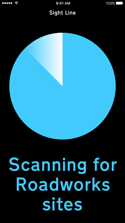
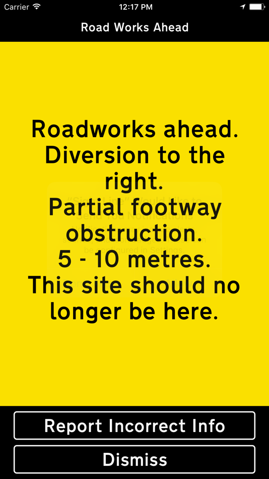
Launch the app when you set off and it will run in the background for an hour scanning for nearby sites. When you come within a few metres of a site that is using the Sight Line system the app will issue a notification of roadworks ahead. Selecting the notification will trigger the full site description.
If the app is not running and you encounter a site and would like to find out about it you and open the app and the the description will play within a few seconds.
The Sight Line system is currently being used in the following areas by the these organisations:
Wolverhampton area, National Grid and Balfour Beatty
Continued use of GPS running in the background can dramatically decrease battery life.
螢幕擷取畫面
價錢
- 今天: 免費
- 最小值: 免費
- 最大值: 免費
追蹤票價
開發人員
- Ross Atkin
- 平台: iOS 應用程式 (5) iOS 遊戲 (1)
- 清單: 0 + 0
- 點數: 0 + 10 ¡
- 排名: 0
- 評測: 0
- 折扣: 0
- 影片: 0
- RSS: 訂閱
點數
0 ☹️
排名
0 ☹️
清單
0 ☹️
評測
成為第一個評論 🌟
其他資訊
聯絡人
- 個人網站:
 http://www.sight-line.uk
你可能還喜歡
-
- Sight Calc
- iOS 應用程式: 地圖與導航 由: NUVOCOM INCORPORATED
- $1.99
- 清單: 0 + 0 排名: 0 評測: 0
- 點數: 0 + 7 (5.0) 版本: 2.0 Sight Calc is a specialized calculator for calculating sight reductions via the "Law of Cosines" method. It does not use Nautical Almanac data, so you must first compute LHA (Local ... ⥯
-
- LandMap Property Line Finder
- iOS 應用程式: 地圖與導航 由: Kain Suite Pte. Ltd.
- 免費
- 清單: 0 + 0 排名: 0 評測: 0
- 點數: 1 + 1,341 (4.3) 版本: 2.0.10 Get land property details without conducting a geological survey? Landmap offers land analysis tool with transparent and up-to-date parcel data. With over 165 million parcel records ... ⥯
-
- Visalia V-LINE
- iOS 應用程式: 地圖與導航 由: VISALIA, CITY OF (INC)
- 免費
- 清單: 0 + 0 排名: 0 評測: 0
- 點數: 0 + 0 版本: 3.9.7 Ride the V-Line from Visalia to Fresno with stops at Visalia Transit Center, Visalia Airport, Fresno Airport, Fresno State, Courthouse Park. This app displays real-time locations of ... ⥯
-
- Blue Line Tracking
- iOS 應用程式: 地圖與導航 由: AA Residential Security & Monitoring Corp.
- 免費
- 清單: 0 + 0 排名: 0 評測: 0
- 點數: 0 + 0 版本: 2.14.5 Access, track and send commands to your GPS enabled assets remotely. ⥯
-
- AppyParking+ Plan, Park & Pay
- iOS 應用程式: 地圖與導航 由: Yellow Line Parking Ltd
- 免費
- 清單: 0 + 0 排名: 0 評測: 0
- 點數: 2 + 19 (4.1) 版本: 5.1.8 Welcome to the UK's best parking app. Park faster and start saving today. Our easy-to-use app allows you to see and understand all on-street parking areas, restrictions and operating ... ⥯
-
- Blueline Taxis
- iOS 應用程式: 地圖與導航 由: BLUE LINE TAXIS (NEWCASTLE) LTD
- 免費
- 清單: 0 + 0 排名: 0 評測: 0
- 點數: 0 + 16 (4.1) 版本: 741.21.0 Book a taxi in under 10 seconds and experience exclusive priority service from one of the largest taxi firms in North East. You can place the booking directly on our map, and see how ... ⥯
-
- Transit • Subway & Bus Times
- iOS 應用程式: 地圖與導航 由: Transit App, Inc.
- 免費
- 清單: 3 + 0 排名: 0 評測: 0
- 點數: 0 + 817,501 (4.6) 版本: 6.0.6 Transit is your real-time urban travel companion. Open the app to instantly see accurate next departure times, track buses and trains near you on the map, and see upcoming transit ... ⥯
-
- onX Hunt: GPS Hunting Maps
- iOS 應用程式: 地圖與導航 由: onXmaps, Inc.
- 免費
- 清單: 0 + 0 排名: 0 評測: 0
- 點數: 1 + 249,575 (4.9) 版本: 25.39.0 Navigate your next hunt and view species distribution, topo maps, hunting units, and more. Whether you re a private or public land hunter, know where you stand with land ownership ... ⥯
-
- New York Subway MTA Map NYC
- iOS 應用程式: 地圖與導航 由: Mapway Limited
- 免費
- 清單: 0 + 0 排名: 0 評測: 0
- 點數: 0 + 107,453 (4.6) 版本: 5.5.6 New York Subway uses the official MTA subway map and includes a helpful transit route planner. With over 12 million downloads worldwide this NYC subway map is free to download and will ⥯
-
- Citymapper: All Live Transit
- iOS 應用程式: 地圖與導航 由: Citymapper Limited
- 免費
- 清單: 0 + 3 排名: 0 評測: 0
- 點數: 1 + 95,305 (4.9) 版本: 11.35.3 Instantly compare your travel options in real-time across all transport modes globally! Easily navigate your city with turn-by-turn directions for all your public transportation, ... ⥯
-
- HuntWise: A Better Hunting App
- iOS 應用程式: 地圖與導航 由: Sportsman Tracker
- 免費
- 清單: 0 + 0 排名: 0 評測: 0
- 點數: 0 + 65,322 (4.7) 版本: 9.3.2 HuntWise provides the ultimate hunting advantage that optimizes your outdoor experience and increases your odds of filling your tag and your freezer every season. Here s how: WEATHER ... ⥯
-
- LandGlide: Find Property Lines
- iOS 應用程式: 地圖與導航 由: Real Estate Portal USA, LLC
- 免費
- 清單: 0 + 0 排名: 0 評測: 0
- 點數: 0 + 53,672 (4.8) 版本: 5.4.0 LandGlide® is a premier property data app, giving you the most advanced and comprehensive parcel data, property line maps, and satellite maps. Whether you re a real estate agent, ... ⥯
-
- Transit Stop: CTA Tracker.
- iOS 應用程式: 地圖與導航 由: Kramer Concepts, LLC
- 免費
- 清單: 0 + 0 排名: 0 評測: 0
- 點數: 0 + 30,994 (4.6) 版本: 9.41 Transit Stop: CTA Tracker gives you quick and easy access to bus and train ( L ) arrival time estimates for your favorite Chicago Transit Authority (CTA) stop. Features Include: ~ ... ⥯
-
- ETA - GPS & maps driving times
- iOS 應用程式: 地圖與導航 由: Eastwood
- $4.99
- 清單: 7 + 7 排名: 0 評測: 0
- 點數: 4 + 679 (3.8) 版本: 2.8.0 ** ETA supports the latest iOS and watchOS features including informative iOS Home Screen widgets and powerful complications for your Apple Watch watch face. With ETA you'll always ... ⥯