| 開發人員: | SkyCharts LLC (5) | ||
| 價錢: | 免費 | ||
| 排名: | 0 | ||
| 評測: | 0 寫評論 | ||
| 清單: | 0 + 0 | ||
| 點數: | 0 + 1 (5.0) ¡ | ||
| App Store | |||
描述
")
Due to no freely avialable charts, please note that for charts outside of USA&Brazil non current ONC/VFR with a current openAIP overlay is available, but NO IFR charts or plates are available.
Includes a free 30 day trial!
If you wish to continue using SkyCharts after the trial, please purchase a $3.99/month subscription. Note that buying a subscription does not unlock any additional features.
See full description regarding auto-renewing subscriptions, privacy policy and EULA below.
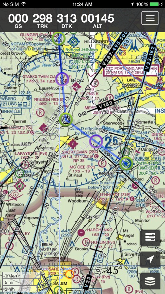
For USA/Alaska, the application has all current FAA VFR (sectional+WAC), IFR (High and Low), TAC, FLY (flip side of TAC chart), Helicopter, Gulf Coast WAC, Gulf Of Mexico, and Wall aviation charts.
Grand Canyon charts are included in the TAC charts, and Bahamas and Mexico as WAC charts.
Brazil has VFR, IFR (High and Low) and approach plates.
Also included is a METAR/TAF overlay, and an IFR overlay to view routes on top of VFR charts.
Its very easy to create and modify routes directly on the map or by drag&drop in table.
Navigation readout is configurable to fit exactly what you want to see. It also has a nifty auto-layout feature that selects fields for you in both portrait and landscape mode.
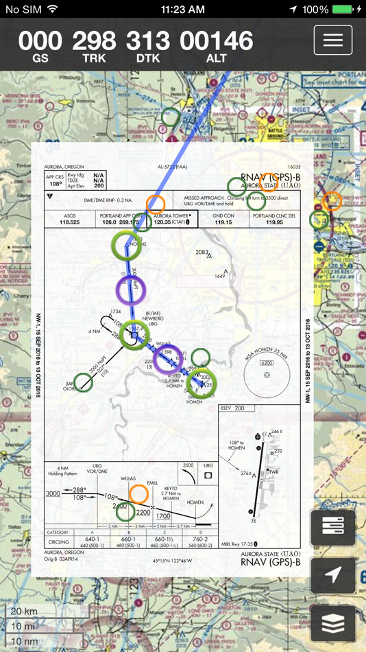
DOUBLE TAP on map to view A/FD and approach plates.
Map has VFR/IFR/LIFR color-coded weather METARs, with orange TAFs.
SUA (Special Use Airspace) information is also available.
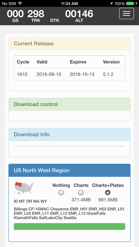
Download charts and plates for offline usage.
Features:
* Fast zoom/scroll of included charts using standard gestures.
* Allows download of charts for offline usage. Charts are selected on a region basis.
* Navigation computes GS, TRK, DTK, DIS & ETE to final waypoint.
* METAR/TAF color coded dots according to ADDS: http://www.skycharts.net/?page_id=421
* Double tap on airport to select A/FD and TPPs/IAPs to view.
* Huge built-in navigation database, with all 20,000 airports, 45,000 FAA IFR/VFR navigation fixes and 2,100 FAA VOR/ADF fixes.
For more information, please see the webpage at
http://www.skycharts.net
The monthly subscription of SkyCharts XC aviation data of $3.99 is auto-renewed. Payment will be charged to your iTunes/App Store account at confirmation of purchase. You can turn off auto-renew at any time from your iTunes/App Store account settings, but you must do so at least 24 hours before the end of the current subscription period to avoid being billed for the next cycle. No cancellation of the current subscription is allowed during the active period. Any unused portion of a free trial period will be forfeited when you purchase a subscription to SkyCharts XC.
The privacy policy and EULA can be found here:
http://www.skycharts.net/?page_id=1465
For fast response to all questions, comments or suggestions, please email support@skycharts.net
螢幕擷取畫面


價錢
- 今天: 免費
- 最小值: 免費
- 最大值: 免費
追蹤票價
開發人員
- SkyCharts LLC
- 平台: Android 應用程式 (2) iOS 應用程式 (3)
- 清單: 0 + 0
- 點數: 0 + 112 ¡
- 排名: 0
- 評測: 0
- 折扣: 0
- 影片: 0
- RSS: 訂閱
點數
未找到 ☹️
排名
未找到 ☹️
清單
未找到 ☹️
評測
成為第一個評論 🌟
其他資訊
你可能還喜歡
-
- Sky-Map
- iOS 應用程式: 地圖與導航 由: RS-Datentechnik
- * 免費
- 清單: 0 + 0 排名: 0 評測: 0
- 點數: 3 + 1 (3.0) 版本: 3.06 Sky-Map is a Moving Map navigation and flight planning system. Like the Sky-Map Versions for other platforms it contains the following functionality: - Moving Map: Displays the actual ... ⥯
-
- EFB Suite
- iOS 應用程式: 地圖與導航 由: Pan Aero
- 免費
- 清單: 0 + 0 排名: 0 評測: 0
- 點數: 1 + 0 版本: 3.3 EFB Suite provides 4 core functionalities: 1. Operator and Aircraft Documentation Library 2. Electronic Journey Log and Electronic Hold Items List (HIL) 3. Flight Documentation ... ⥯
-
- Sky Gauge
- iOS 應用程式: 地圖與導航 由: S. Justin Gengo
- $0.99
- 清單: 0 + 0 排名: 0 評測: 0
- 點數: 0 + 0 版本: 2.5.1 Sky Gauge: Elevation Tracker for Apple Watch Experience the simplicity of altitude tracking with Sky Gauge on your Apple Watch. With just a tap, Sky Gauge begins measuring changes in ... ⥯
-
- Sky Tracker Plus
- iOS 應用程式: 地圖與導航 由: ONESKY COMMUNICATIONS LIMITED
- 免費
- 清單: 0 + 0 排名: 0 評測: 0
- 點數: 0 + 0 版本: 2.0.2 Sky Tracker Plus : Real-time tracking: This feature allows you to track the location of the vehicle in real-time, usually through a web-based interface or a mobile app. Geofencing: ... ⥯
-
- Sky Stadium Parking
- iOS 應用程式: 地圖與導航 由: Frogparking
- 免費
- 清單: 0 + 0 排名: 0 評測: 0
- 點數: 0 + 0 版本: 1.0.3 Parking made easy. Make payments, manage long-term permits, check availability and get directions to Care Park managed lots. ⥯
-
- Navigraph Charts
- iOS 應用程式: 地圖與導航 由: Navigraph
- 免費
- 清單: 0 + 1 排名: 0 評測: 0
- 點數: 0 + 2,116 (4.9) 版本: 8.38.3 Looking for the most comprehensive software solution for flight simulation? Navigraph Charts is your co-pilot. Navigraph Charts 8 has been developed with emphasis on delivering a ... ⥯
-
- Approach Charts
- iOS 應用程式: 地圖與導航 由: Candidus LLC
- 免費
- 清單: 0 + 0 排名: 0 評測: 0
- 點數: 0 + 5 (2.0) 版本: 2.6.0 FAA Instrument Approach charts (Terminal Procedures) for the US - Includes Airport diagrams, Minimums, STARS and DPs - Includes detailed airport and runway information for all US ... ⥯
-
- i-Boating: Marine Charts & Gps
- iOS 應用程式: 地圖與導航 由: Bist LLC
- 免費
- 清單: 0 + 1 排名: 0 評測: 0
- 點數: 0 + 13,423 (4.5) 版本: 160.0.0 This App offers access to Marine Charts for USA,Canada,UK/Ireland,Germany,Netherlands/Holland & Europe Rivers (Danube,Drava,Rhein etc). Coverage includes NOAA marine vector ... ⥯
-
- FlyQ+ EFB
- iOS 應用程式: 地圖與導航 由: Seattle Avionics, Inc.
- 免費
- 清單: 0 + 0 排名: 0 評測: 0
- 點數: 1 + 807 (4.0) 版本: 7.1.1 FlyQ+ EFB is a top-rated aviation app because it makes your flying easier and safer by thoughtfully integrating powerful features in a way that minimizes the number of screen taps and ... ⥯
-
- AvPlan EFB
- iOS 應用程式: 地圖與導航 由: BJA Consulting Pty Ltd
- 免費
- 清單: 0 + 0 排名: 0 評測: 0
- 點數: 1 + 90 (4.7) 版本: 9.9.6 Get flying faster with AvPlan EFB - the premier lifetime Electronic Flight Bag that grows with you. Continuing to lead the market with unparalleled innovation and functionality, AvPlan ⥯
-
- PRO CHARTS - Marine Navigation
- iOS 應用程式: 地圖與導航 由: MiraTrex, Inc.
- 免費
- 清單: 0 + 0 排名: 0 評測: 0
- 點數: 0 + 8,338 (4.5) 版本: 5.70 MiraTrex PRO CHARTS™ is a powerful, yet easy-to-use marine navigation system. Whether you re a fisherman, weekend cruiser, sailor, diver, jet-skier, or an offshore captain needing to ... ⥯
-
- iFly EFB
- iOS 應用程式: 地圖與導航 由: Adventure Pilot, LLC
- 免費
- 清單: 0 + 0 排名: 0 評測: 0
- 點數: 2 + 196 (4.6) 版本: 13.3.53 iFly EFB delivers the perfect combination of affordability, capability, and usability for both VFR and IFR Pilots. Safely and quickly get the information you need so you can focus on ... ⥯
-
- Nautical Charts & Maps
- iOS 應用程式: 地圖與導航 由: LW Brands, LLC
- $8.99
- 清單: 0 + 0 排名: 0 評測: 0
- 點數: 0 + 3,698 (4.6) 版本: 1.13 Main Features Include: + NOAA Electronic Navigational Charts (ENC) + NOAA Weather Map Overlays -- ELECTRONIC NAVIGATION CHARTS -- Electronic Navigational Charts (ENC) are vector data ... ⥯
-
- Orca: Boat GPS, Charts, Routes
- iOS 應用程式: 地圖與導航 由: Orca Technologies AS
- 免費
- 清單: 0 + 1 排名: 0 評測: 0
- 點數: 0 + 192 (4.5) 版本: 2025.32.2 The ultimate boating App - Orca * Crisp Online and Offline Nautical Charts * Modern chart design to maximize legibility. * Satellite Maps to ease your approaches * Tailored routes for ... ⥯