| 開發人員: | Divelements Limited (2) | ||
| 價錢: | 免費 | ||
| 排名: | 0 | ||
| 評測: | 0 寫評論 | ||
| 清單: | 0 + 0 | ||
| 點數: | 0 + 529 (4.8) ¡ | ||
| App Store | |||
描述
")
Use this app to access your SkyDemon subscription on your iOS device, unlocking SkyDemon's powerful features while on the move.
FLIGHT PLANNING FEATURES
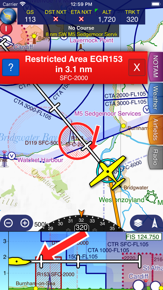
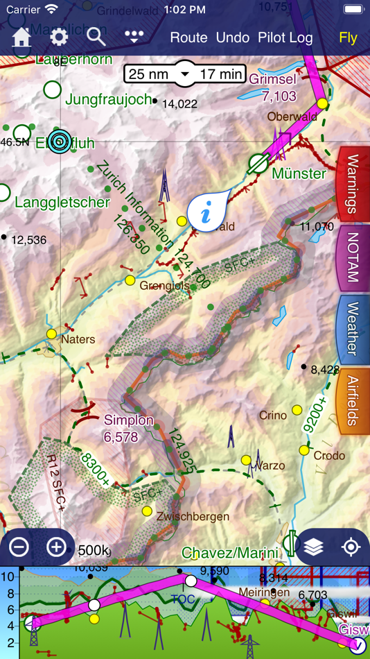
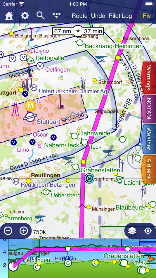
- SkyDemon vector charts are the clearest aeronautical charts you'll ever use, with dynamic airspace clipping and choice of map layers
- Route planning is as simple as touching consecutive waypoints and dragging to make changes
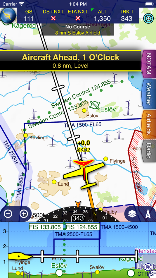
- Virtual Radar shows how your route relates to airspace, terrain, obstructions and other features
- Pilot Log facility calculates headings and groundspeeds from actual wind data, and shows useful frequencies
- Plates and other documents for relevant airfields are displayed automatically as you plan, and many are available georeferenced for use in flight
- Intuitive pan, pinch and rotate support with no loss of map clarity or text legibility
- File a VFR flightplan for your route directly to air traffic controllers
- Automatic TAF, METAR and SIGMET briefing as you plan a route, with graphical decoding
- Rainfall data can be overlaid on the main map, with animation, showing the trend of rainfall over time
- Integration of GAFOR route forecasts for Switzerland, Austria, Slovenia and Croatia
- Both narrow-route and area NOTAM briefings available, updated as you plan
- Advanced NOTAM graphical interpretation and depiction on the main map
- Easily print your PLOG and the output from various briefings
- Warnings for airspace and other potential hazards to your flight, updated in real time
- Airfield Admin Information shows useful contacts and other details for airfields featured in our charts
- Forecast winds aloft are automatically retrieved for the flight time and displayed on the map
- Create an advanced flight performance profile for each aircraft you use
- ATS Routes mode offers an alternative chart presentation for flight along airways
- Accurate fuel, weight and balance calculations including flight costings
- Create an unlimited number of user-defined waypoints
- Analyse your track logs for posterity
- Choose between six different vector chart styles
- Extensive European chart coverage as standard
GPS NAVIGATION FEATURES
- Intelligent warnings for approaching airspace, NOTAM, obstacles, terrain and other hazards
- Virtual Radar shows a side-on projection of all approaching features and how your trajectory relates to them
- Vector map automatically follows the aircraft in north up, track up or course up orientation
- Clear and concise instruments show you flight statistics and help keep you on track
- An HSI/ILS instrument helps you keep to your planned route and line up early for approach
- Live Pilot Log shows progress through your route, ETAs, ATAs and useful frequencies based on your current position
- TerrainSafe dynamically colours mountainous terrain around you to quickly identify safer areas
- Direct To allows easy re-routing in a hurry by picking from a selection of nearby airfields
- Approach Information shows runway diagrams, TAF, METAR, NOTAM and other airfield details useful for making an approach
- Live updates of TAF and METAR while in flight, with associated alerts*
- Extended runway centrelines appear automatically on the map as you near your destination airfield
- Permanent display of position relative to nearest well-known waypoint, for position reporting
- Easy changing of the planned route while in flight by touching and dragging
Continued use of GPS running in the background can dramatically decrease battery life.
* Internet connection required for live weather update while in flight
螢幕擷取畫面
新功能
- 版本: 4.2.2
- 發佈日期:
- - Flight logs are now presented with a preview map and with better information display
- SkyDemon is now translated into Polish
價錢
- 今天: 免費
- 最小值: 免費
- 最大值: 免費
追蹤票價
開發人員
- Divelements Limited
- 平台: Android 應用程式 (1) iOS 應用程式 (1)
- 清單: 0 + 0
- 點數: 0 + 3,237 ¡
- 排名: 0
- 評測: 0
- 折扣: 0
- 影片: 0
- RSS: 訂閱
點數
0 ☹️
排名
0 ☹️
清單
0 ☹️
評測
成為第一個評論 🌟
其他資訊
聯絡人
- 🌟 分享
- App Store
你可能還喜歡
-
- Sky-Map
- iOS 應用程式: 地圖與導航 由: RS-Datentechnik
- * 免費
- 清單: 0 + 0 排名: 0 評測: 0
- 點數: 3 + 1 (3.0) 版本: 3.08 Sky-Map is a Moving Map navigation and flight planning system. Like the Sky-Map Versions for other platforms it contains the following functionality: - Moving Map: Displays the actual ... ⥯
-
- Sky Gauge
- iOS 應用程式: 地圖與導航 由: S. Justin Gengo
- $0.99
- 清單: 0 + 0 排名: 0 評測: 0
- 點數: 0 + 0 版本: 2.5.1 Sky Gauge: Elevation Tracker for Apple Watch Experience the simplicity of altitude tracking with Sky Gauge on your Apple Watch. With just a tap, Sky Gauge begins measuring changes in ... ⥯
-
- Sky Tracker Plus
- iOS 應用程式: 地圖與導航 由: ONESKY COMMUNICATIONS LIMITED
- 免費
- 清單: 0 + 0 排名: 0 評測: 0
- 點數: 0 + 0 版本: 2.0.2 Sky Tracker Plus : Real-time tracking: This feature allows you to track the location of the vehicle in real-time, usually through a web-based interface or a mobile app. Geofencing: ... ⥯
-
- Sky Stadium Parking
- iOS 應用程式: 地圖與導航 由: Frogparking
- 免費
- 清單: 0 + 0 排名: 0 評測: 0
- 點數: 0 + 0 版本: 1.0.3 Parking made easy. Make payments, manage long-term permits, check availability and get directions to Care Park managed lots. ⥯
-
- skybro Digital Sky
- iOS 應用程式: 地圖與導航 由: skybro
- 免費
- 清單: 0 + 0 排名: 0 評測: 0
- 點數: 0 + 0 版本: 1.5 IMPORTANT All users who have previous versions of skybro Digital Sky should update the app to v1.4 or later one. skybro Digital Sky allows you to: - see the location of other airspace ... ⥯
-
- C.A.T: Canada Air Sky Tracker
- iOS 應用程式: 地圖與導航 由: fikret urgan
- 免費
- 清單: 0 + 0 排名: 0 評測: 0
- 點數: 0 + 0 版本: 2.2.3 Looking to track live flights across Canada? Want to get real-time information about routes, altitudes, and speed of all Canadian airlines? Your solution is here - introducing Canada ... ⥯
-
- Speedometer 55 GPS Speed & HUD
- iOS 應用程式: 地圖與導航 由: Stanislav Dvoychenko
- 免費
- 清單: 0 + 0 排名: 0 評測: 0
- 點數: 0 + 61,380 (4.8) 版本: 5.7 A high quality Speedometer app with the same sophisticated brain inside as our paid version. When you go over a preset speed limit, the large digits change colour from green to red and ⥯
-
- SkyTrack V2
- iOS 應用程式: 地圖與導航 由: Sheraz Sarwar
- 免費
- 清單: 0 + 0 排名: 0 評測: 0
- 點數: 0 + 0 版本: 1.2 Sky Track (Pvt.) Ltd have a unique state of the art range of car tracking, and vehicle tracking devices to fit all of your car tracking requirements. The vehicle tracker uses the ... ⥯
-
- GPS Speedometer MPH Tracker
- iOS 應用程式: 地圖與導航 由: BITHAUS.TECH, UNIPESSOAL LDA
- 免費
- 清單: 0 + 0 排名: 0 評測: 0
- 點數: 1 + 11,324 (4.7) 版本: 7.1.4 Transform every journey into valuable data with GPS Speedometer - the most comprehensive speed tracking app for driving, cycling, boating, and beyond. Experience professional-grade ... ⥯
-
- PlanetFinder Pro
- iOS 應用程式: 地圖與導航 由: Johan Burgler
- $1.99
- 清單: 0 + 1 排名: 0 評測: 0
- 點數: 9 + 8 (5.0) 版本: 1.3 Your Guide to the Night Sky Explore the stars and planets with PlanetFinder Pro, the ultimate stargazing companion! Effortlessly turn your iPhone into a powerful tool for navigating ... ⥯
-
- KakaoMap - Korea No.1 Map
- iOS 應用程式: 地圖與導航 由: Kakao Corp.
- 免費
- 清單: 0 + 1 排名: 0 評測: 0
- 點數: 0 + 4,701 (4.7) 版本: 6.11.1 KakaoMap will show you the fastest routes in Korea! With KakaoMap, you can find everything you want in a map app, from directions to hot restaurants and local attractions, and more! ... ⥯
-
- Satellite Finder (Pro)
- iOS 應用程式: 地圖與導航 由: Peter Bohl
- 免費
- 清單: 0 + 0 排名: 0 評測: 0
- 點數: 0 + 5,071 (4.6) 版本: 2.71 The app helps you to align your satellite antenna. Based on your location and the selected satellite the app shows you in which horizontal and vertical direction you have to align your ⥯
-
- HeadUp - What plane is this?
- iOS 應用程式: 地圖與導航 由: Selcuk Dolapci
- 免費
- 清單: 0 + 0 排名: 0 評測: 0
- 點數: 4 + 0 版本: 1.0 You hear the roar. You look up. A contrail splits the sky. Your AvGeek instinct kicks in: What is that? Where is it going? Stop scrambling for clunky flight tracking apps. HeadUp is ... ⥯
-
- SkyReg
- iOS 應用程式: 地圖與導航 由: ILTERRA
- 免費
- 清單: 0 + 0 排名: 0 評測: 0
- 點數: 0 + 2 (1.0) 版本: 1.1 SkyReg is a powerful app for identifying the locations of sky objects, such as clouds, using your smartphone's camera. Ideal for pilots, meteorologists, and anyone interested in sky ... ⥯