| Nhà phát triển: | Civi Corp (3) | ||
| Giá bán: | $0.99 | ||
| Xếp hạng: | 0 | ||
| Đánh giá: | 0 Viết đánh giá | ||
| Danh sách: | 0 + 0 | ||
| Điểm: | 1 + 382 (4.3) ¡ | ||
| App Store | |||
Mô tả
")
Solocator is trusted by professionals, government agencies, and industries worldwide for reliable photo documentation.
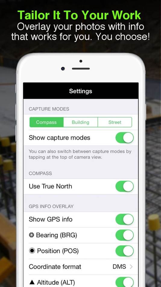
TAILOR OVERLAY INFORMATION TO YOUR NEEDS
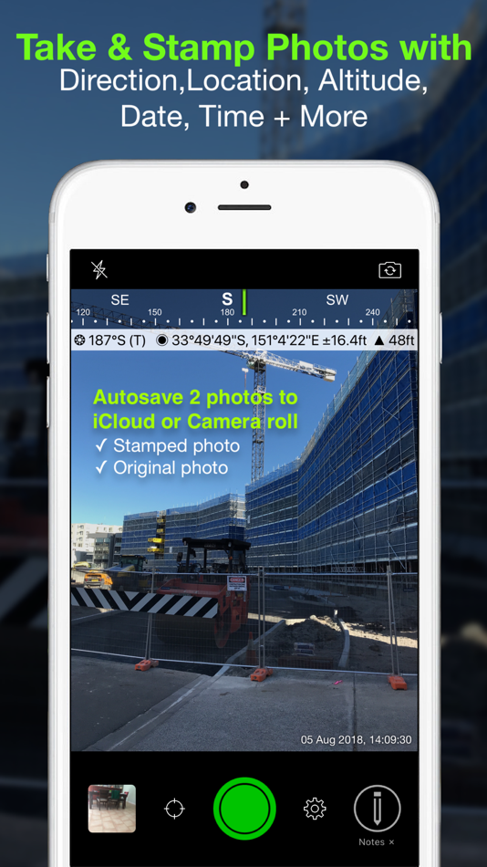
Capture & stamp on your photos:
+ GPS position (Latitude & Longitude in various formats) ± accuracy
+ UTM/MGRS coordinates (Industry Pack)
+ Street address (Industry Pack)
+ Direction – bearing
+ Altitude (MLS / HAE)
+ Tilt & Roll angles
+ Local date & time (based on GPS location)
+ Local time zone
+ UTC time
+ Compass display
+ Cardinal directions
+ Building facade direction, e.g. "North elevation"
+ Field Notes (Industry Pack)
+ Company Logo (Industry Pack)
AUTOSAVE PHOTOS TO iCLOUD & CAMERA ROLL
Autosave two photos at once: one stamped with the selected overlays and the other as an original high-resolution photo.
SORT, SEARCH, SHARE OR EMAIL
+ Photos are sorted by time, location, distance from current location and project name.
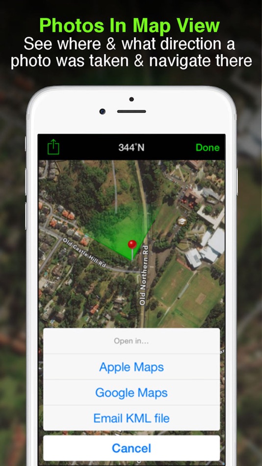
+ View photo direction and location in map view and navigate there.
+ Share photos individually or as a zip file via the share sheet.
+ Search for photos by date, date range or notes and street addresses.
+ Email photos including the following information:
- Exif metadata
- Compass direction
- GPS position ± accuracy
- Altitude
- Tilt & Roll
- Date & time taken
- Street address (Industry Pack)
- Cardinal Directions
- Elevation of building facade
- Links to maps so the receiver can navigate there easily
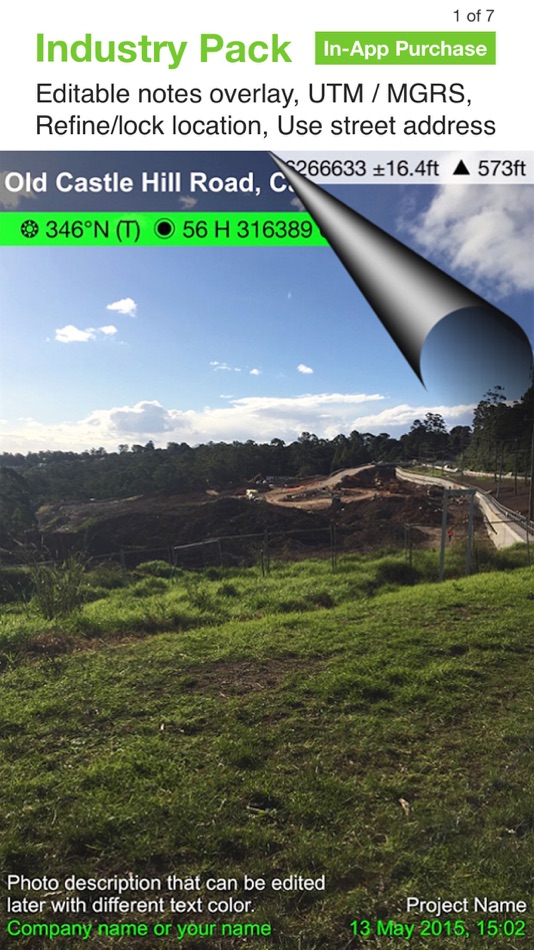
** INDUSTRY PACK ** (In-App Purchase) "One-off charge"
EDITABLE NOTES OVERLAY
Stamp photos with "Project name", "Description" & “Watermark”. The Project Name field can be used as a job or ticket number. The Watermark field is typically used for a company or username. You can also edit these fields later.
WATERMARK LOGO
Add your Company Logo to photos. Logo’s size, opacity, and position can be customised for both portrait and landscape photos. To get you started, a Solocator icon is included, which can be replaced.
CUSTOM EXPORT FILENAME
Define your photo export filename from a selection of fields: Project Name, Description, Watermark, Street Address, Date/Time, Number#, Custom text field, Photo type (original/stamped), and Coordinates (DD.dddddd, UTM, UTM Bands, MGRS).
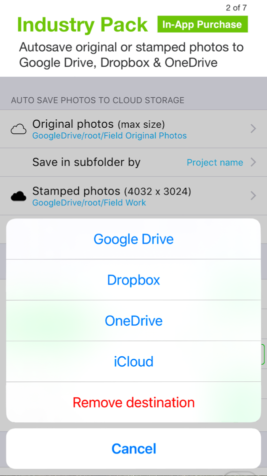
AUTOSAVE OR EXPORT PHOTOS TO CLOUD STORAGE
Autosave original and stamped photos to Google Drive, Dropbox, and OneDrive (Personal & For Business), including SharePoint Sites and Teams. You can also save photos in date or project name subfolders - automatically.
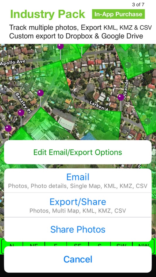
PHOTO DATA in KML, KMZ & CSV
Along with photos, email or export photo data and notes in KML, KMZ or CSV formats. Both email and export buttons are customisable to suit your data requirements.
STREET ADDRESS & UTM/MGRS
Add street address to your overlay or use UTM/, UTM Bands & MGRS coordinate formats.
BATCH EDIT NOTES & OVERLAY FIELDS
Select photos from the library and edit Project Name, Description & Watermark fields in one go.
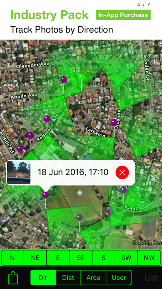
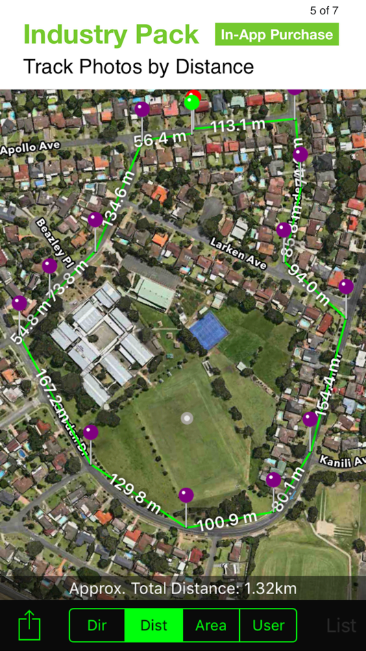
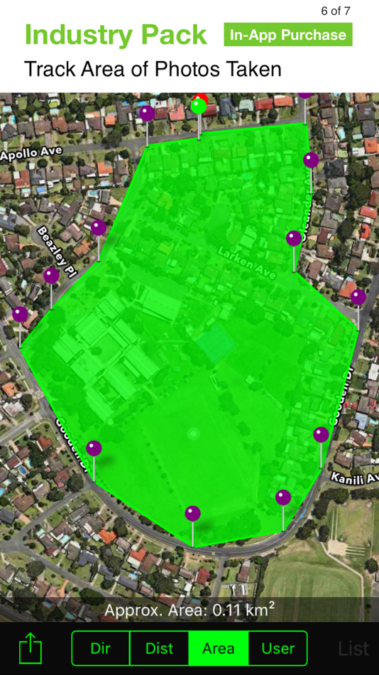
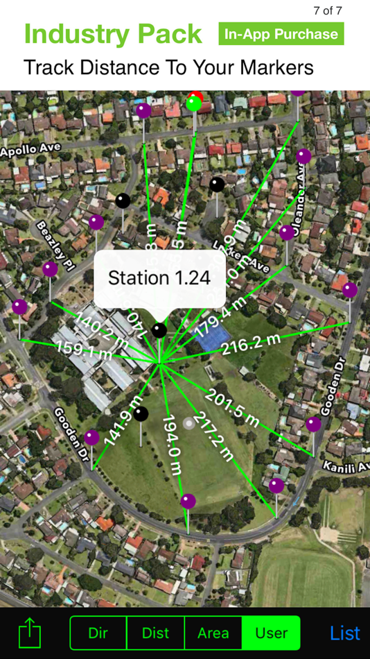
TRACK PHOTOS IN MAP VIEW
View photos by direction, the distance between photos, area of photos taken and distance to your added markers via imported KML files or dropped pins.
REFINE & LOCK GPS LOCATION
Ideal for those working in and around buildings; to improve your GPS location. You can also use it to lock the asset position you're photographing.
COMPACT VIEW
Switch off Compass, Building and Street modes and only show the GPS info bar for a more compact view.
VPP Customers: https://solocator.com/enterprise-app-for-mdms/
Terms of Use: https://www.apple.com/legal/internet-services/itunes/dev/stdeula/
Ảnh chụp màn hình
Tính năng mới
- Phiên bản: 2.22
- Cập nhật:
- Improved Photo Export:
- Fixed an issue where duplicate photos were exported with the same filename.
- Enhanced color accuracy in exported photos.
- New option to apply stamped photo size and quality settings to original photos, or keep your device’s default maximum size.
OneDrive Improvements:
- Fixed a bug affecting autosaving or uploading photos after long periods of inactivity.
- Additional enhancements to improve reliability of autosaving to OneDrive and added more detail to error alerts if relevant.
Camera Controls & Permissions:
- Fixed a rare issue where the shutter button would trigger automatically.
- New setting to enable or disable using volume buttons as the shutter.
- Added direct links in settings for managing location and camera roll permissions.
Giá bán
- Hôm nay: $0.99
- Tối thiểu: $0.99
- Tối đa: $0.99
Theo dõi giá
Nhà phát triển
- Civi Corp
- Nền tảng: Android Ứng dụng (1) iOS Ứng dụng (2)
- Danh sách: 0 + 0
- Điểm: 3 + 1,347 ¡
- Xếp hạng: 0
- Đánh giá: 0
- Giảm giá: 0
- Video: 0
- RSS: Đăng ký
Điểm
-

- 12,853 Lance Eliakim Sotto
- +1

Xếp hạng
0 ☹️
Danh sách
0 ☹️
Đánh giá
Hãy là người đầu tiên đánh giá 🌟
Thông tin bổ sung
- Phiên bản: 2.22
- Danh mục:
iOS Ứng dụng›Bản đồ và dẫn đường - HĐH:
iPad,iPhone,iOS 15.0 trở lên - Kích thước:
29 Mb - Ngôn ngữ được hỗ trợ:
English - Xếp hạng nội dung:
4+ - App Store Xêp hạng:
4.3(382) - Cập nhật:
- Ngày phát hành:
Danh bạ
- Trang web:
 https://solocator.com
- 🌟 Chia sẻ
- App Store
Bạn cũng có thể thích
-
- GPS Timestamp Camera Photo
- iOS Ứng dụng: Bản đồ và dẫn đường Bởi: Followal Infotech LLP
- * Miễn phí
- Danh sách: 0 + 0 Xếp hạng: 0 Đánh giá: 0
- Điểm: 1 + 2 (5.0) Phiên bản: 1.4 Photo Timestamp App Add Date, Time, and Location to Your Photos Easily add date, time, location, and watermark to your photos with the Photo Timestamp App the most accurate and ... ⥯
-
- GPS Map Camera & Timestamp
- iOS Ứng dụng: Bản đồ và dẫn đường Bởi: Darshan Navapariya
- Miễn phí
- Danh sách: 0 + 0 Xếp hạng: 0 Đánh giá: 0
- Điểm: 0 + 0 Phiên bản: 1.1.1 GPS Map Camera & Timestamp Ever need to prove exactly where and when a photo was taken? Wish your travel photos had a map right on them for context? GPS Map Camera & Timestamp is the ... ⥯
-
- GPS Map Camera Geotag Location
- iOS Ứng dụng: Bản đồ và dẫn đường Bởi: Nikhil Viradiya
- Miễn phí
- Danh sách: 0 + 0 Xếp hạng: 0 Đánh giá: 0
- Điểm: 1 + 22 (4.8) Phiên bản: 2.0 Track your current location along with your captured photos by GPS Map Camera: Geotag Photos & Add GPS. Send your geotagged location of Street / Place added photos to your Family & ... ⥯
-
- GPS Maps Camera
- iOS Ứng dụng: Bản đồ và dẫn đường Bởi: Krutagna Infotech
- Miễn phí
- Danh sách: 0 + 0 Xếp hạng: 0 Đánh giá: 0
- Điểm: 0 + 2 (5.0) Phiên bản: 1.9 Capture and customise your photos with our all-in-one GPS Maps Camera app, designed for photographers, traveler s, and outdoor enthusiasts. Discover a comprehensive suite of features ... ⥯
-
- GPS Map Camera & Video Capture
- iOS Ứng dụng: Bản đồ và dẫn đường Bởi: Khushali Sabhadiya
- * Miễn phí
- Danh sách: 1 + 1 Xếp hạng: 0 Đánh giá: 0
- Điểm: 0 + 93 (4.6) Phiên bản: 1.5.5 Gio Tag Camera is an app for mobile devices that allows users to take photos and embed them with GPS location data, as well as a map of the location. This app is especially useful for ... ⥯
-
- MapCam - GPS Map Camera
- iOS Ứng dụng: Bản đồ và dẫn đường Bởi: HKinfoway Technologies
- Miễn phí
- Danh sách: 0 + 0 Xếp hạng: 0 Đánh giá: 0
- Điểm: 0 + 5 (5.0) Phiên bản: 1.5 Capture, Tag, and Organize Your Photos with GPS & Timestamps! MapCam - GPS Map Camera is a powerful geotagging photo editor app designed for travelers, professionals, and field workers ⥯
-
- GPS-Platform
- iOS Ứng dụng: Bản đồ và dẫn đường Bởi: GPS Plateform Ltd
- Miễn phí
- Danh sách: 0 + 0 Xếp hạng: 0 Đánh giá: 0
- Điểm: 0 + 0 Phiên bản: 1.2 This is mobile client of GPS-Platform tracking application. To use the application, you need a personal account or access to hosted software. Demo Account Credentials: Username: demo ... ⥯
-
- GPS TechTracker Pro
- iOS Ứng dụng: Bản đồ và dẫn đường Bởi: GPS California SA de CV
- Miễn phí
- Danh sách: 1 + 0 Xếp hạng: 0 Đánh giá: 0
- Điểm: 1 + 0 Phiên bản: 2.18.11 GPS TechTracker provides you with a powerful tool with real-time capability that includes detailed professional reports, reproduction of the routes used in each trip, multiple alerts, ... ⥯
-
- Field Command Pro
- iOS Ứng dụng: Bản đồ và dẫn đường Bởi: Field Command Pro
- * Miễn phí
- Danh sách: 0 + 0 Xếp hạng: 0 Đánh giá: 0
- Điểm: 2 + 1 (5.0) Phiên bản: 1.1.27 (Build 14) Field Command is the essential real-time intelligence app for everyone who relies on, works with, or simply loves snow. From professional contractors and ski resort operators to ... ⥯
-
- GPS ASSIST: Vehicle Tracking
- iOS Ứng dụng: Bản đồ và dẫn đường Bởi: GPS ASSIST LTD
- Miễn phí
- Danh sách: 0 + 0 Xếp hạng: 0 Đánh giá: 0
- Điểm: 0 + 0 Phiên bản: 1.1 GPS ASSIST - Smarter Tracking. Requires a GPS ASSIST device to use this app. Take full control of your vehicle s security with GPS ASSIST, the companion app designed to work ... ⥯
-
- Camera Deputatilor
- iOS Ứng dụng: Bản đồ và dẫn đường Bởi: Camera Deputatilor
- Miễn phí
- Danh sách: 0 + 0 Xếp hạng: 0 Đánh giá: 0
- Điểm: 0 + 0 Phiên bản: 1.2.0 Application developed by the Chamber of Deputies to facilitate access to the website www.cdep.ro. It offers quick access to the important sections of the site, such as: agenda, work ... ⥯
-
- Tractor GPS Field Navigation
- iOS Ứng dụng: Bản đồ và dẫn đường Bởi: Innonexa Tech Private Limited
- Miễn phí
- Danh sách: 1 + 1 Xếp hạng: 0 Đánh giá: 0
- Điểm: 2 + 25 (4.8) Phiên bản: 1.21 Tractor GPS Field Navigation Precision Farming Made Simple Take control of your fields with the most reliable and easy-to-use tractor GPS guidance app. Designed for farmers, ... ⥯
-
- Tractor GPS Field Guidance App
- iOS Ứng dụng: Bản đồ và dẫn đường Bởi: Ela Bodar
- * Miễn phí
- Danh sách: 0 + 0 Xếp hạng: 0 Đánh giá: 0
- Điểm: 1 + 0 Phiên bản: 1.1 Tractor GPS guidance app is specifically designed for tractor and machinery operators, offering precise navigation to optimize all agricultural activities. Tailored to boost fieldwork ... ⥯
-
- GPS Fleet Manager
- iOS Ứng dụng: Bản đồ và dẫn đường Bởi: Optimus GPS Tracking Corp
- Miễn phí
- Danh sách: 0 + 0 Xếp hạng: 0 Đánh giá: 0
- Điểm: 0 + 3 (3.3) Phiên bản: 3.10.22 GPS Fleet Manager App is the mobile version of our tracking platform. - Manage your vehicles and other GPS devices. - Track your vehicle in real time. - Receive alerts by: * Push ... ⥯