| 開發人員: | Benjamin Koch (1) | ||
| 價錢: | $7.99 | ||
| 排名: | 0 | ||
| 評測: | 0 寫評論 | ||
| 清單: | 0 + 0 | ||
| 點數: | 0 + 1 (5.0) ¡ | ||
| App Store | |||
描述
")
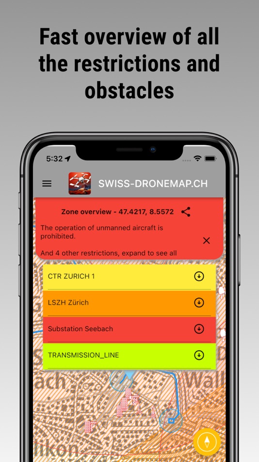
The relevant aviation data get updated each day. DABS data gets updated every hour.
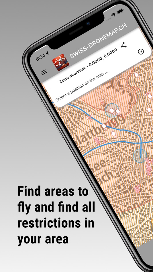
We show you where you can fly and where not.
As a drone pilot, it's essential to know the areas where flying is prohibited or limited to ensure the safety of people and property on the ground, as well as other airspace users such as planes and helicopters. Our map displays all the necessary information about national and cantonal restrictions to help you plan your drone flights accordingly.
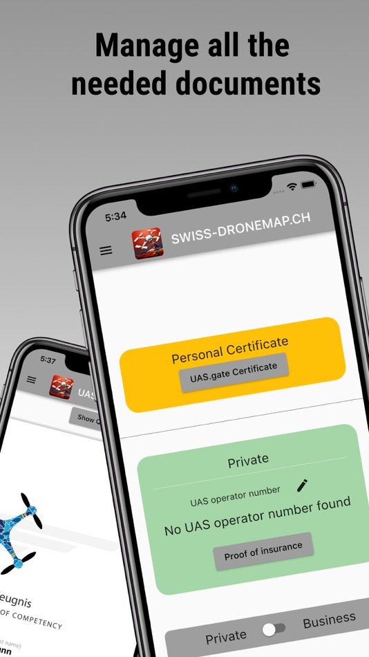
With our app, you can also manage all the documents you need, such as the remote pilot certificate, the operator number and the insurance certificate, both for private and for business, so you always have them with you.
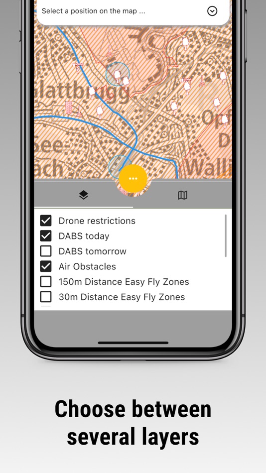
National and Cantonal Restrictions: The following restrictions apply in Switzerland:
5km radius around civil or military airfields: Flying a drone in this area is prohibited unless you have explicit permission from the airfield operator or air traffic control.
Control zones CTR: These are designated airspace areas around airports, where drone flying is only allowed under specific conditions and with the approval of air traffic control.
Civil airfield perimeter according to the sectoral plan for aviation infrastructure or military airfield perimeter according to the sectoral plan for the military: Flying a drone within the perimeter of a civil or military airfield is prohibited.
Penal institutions: Flying a drone over or near a prison is prohibited.
Protection areas for wild animals: There are several protected areas in Switzerland, where drone flying is either prohibited or only allowed under specific conditions.
In the vicinity of nuclear power plants: Flying a drone near a nuclear power plant is prohibited.
Over military zones: Flying a drone over military zones is prohibited.
Certain energy and gas supply infrastructure: Flying a drone near specific energy and gas supply infrastructure is prohibited.
Obstacles for aircraft, such as poles, buildings, transmission lines, and other relevant elements: Drone flying is dangerous near any obstacle, plan ahead with our map.
Nature and forest reserves: There are several protected nature and forest reserves in Switzerland, where drone flying is either prohibited or only allowed under specific conditions.
Using our interactive drone map, you can quickly check the relevant area restrictions before each flight and plan accordingly to ensure a safe and enjoyable drone flying experience. Keep in mind that failure to comply with the restrictions could lead to fines or other legal consequences. So, always be sure to follow the rules and fly responsibly. Start exploring our map now and discover the beauty of Switzerland from above while respecting the airspace regulations!
螢幕擷取畫面


價錢
- 今天: $7.99
- 最小值: $4.99
- 最大值: $7.99
追蹤票價
開發人員
- Benjamin Koch
- 平台: iOS 應用程式 (1)
- 清單: 0 + 0
- 點數: 0 + 1 ¡
- 排名: 0
- 評測: 0
- 折扣: 0
- 影片: 0
- RSS: 訂閱
點數
未找到 ☹️
排名
未找到 ☹️
清單
未找到 ☹️
評測
成為第一個評論 🌟
其他資訊
聯絡人
你可能還喜歡
-
- Swiss Pro Map
- iOS 應用程式: 地圖與導航 由: Garzotto GmbH
- * 免費
- 清單: 0 + 0 排名: 0 評測: 0
- 點數: 0 + 1 (1.0) 版本: 9.9.5 Swiss Pro Map is the map app for Switzerland and the Alpine region: offline maps and useful functions for outdoor activities such as mountain sports, hiking, cycling and aviation. Maps ⥯
-
- Swiss Dive
- iOS 應用程式: 地圖與導航 由: Plurial
- $4.99
- 清單: 0 + 0 排名: 0 評測: 0
- 點數: 0 + 0 版本: 2.0.33 This application georeference the whole diving sites in Switzerland. Even at high altitude or in plain, in lake or in river, the whole diving sites are georeferenced (around 600 ... ⥯
-
- SAC – Swiss Alpine Club
- iOS 應用程式: 地圖與導航 由: Schweizer Alpen-Club SAC
- * 免費
- 清單: 0 + 0 排名: 0 評測: 0
- 點數: 0 + 0 版本: 1.7.6 The perfect companion for your next tour in the Swiss mountains whether you're planning or undertaking a tour. TOURS BY PROS Draw inspiration from more than 6000 different tours all ... ⥯
-
- MyWay Pro
- iOS 應用程式: 地圖與導航 由: Swiss Federation of the Blind
- * 免費
- 清單: 0 + 0 排名: 0 評測: 0
- 點數: 0 + 0 版本: 1.4.3 MyWay Pro is an orientation and navigation app optimised for blind and visually impaired people. Specific information is conveyed to the user by means of acoustic and sensory ... ⥯
-
- CacheToolBox
- iOS 應用程式: 地圖與導航 由: TN-TECHNOLOGY
- $3.99
- 清單: 0 + 1 排名: 0 評測: 0
- 點數: 1 + 3 (5.0) 版本: 8.8.2 NEW: Encode plain text into symbol language NEW: Wherigo Reverse solver CacheToolBox is an ideal tool for all ambitious geocachers and hikers. The app offers conversions for the ... ⥯
-
- Recycling Map
- iOS 應用程式: 地圖與導航 由: Igora-Genossenschaft für Aluminium-Recycling
- 免費
- 清單: 0 + 0 排名: 0 評測: 0
- 點數: 0 + 3 (5.0) 版本: 2.4.0 Official Swiss Recycling Map The Recycling Map shows you more than 16,000 Swiss collection points at a glance. In addition to showing your nearest collection points, the interactive ... ⥯
-
- Hand luggage
- iOS 應用程式: 地圖與導航 由: Marco Tini
- $1.99
- 清單: 0 + 0 排名: 0 評測: 0
- 點數: 1 + 3 (2.7) 版本: 1.2.3 Can't get much simpler than that! Do you have to take a flight and you don't know the allowed size of carry-on baggage? With Hand luggage you can have on hand the complete and updated ... ⥯
-
- ECOFACTOR EV Charging
- iOS 應用程式: 地圖與導航 由: Ekofaktor Netvork, Tov
- 免費
- 清單: 0 + 0 排名: 0 評測: 0
- 點數: 0 + 100 (4.8) 版本: 158 Power your EV journey with ECOFACTOR, where over 180,000 EV drivers across Ukraine, Europe, and Central Asia connect to unlock seamless charging experiences. Find the perfect charging ... ⥯
-
- Geocaching Toolkit iGCT
- iOS 應用程式: 地圖與導航 由: BtStSoft
- 免費
- 清單: 0 + 0 排名: 0 評測: 0
- 點數: 0 + 20 (2.8) 版本: 6.3 Geocaching is a worldwide game of hiding and seeking treasure. A multi-cache involves two or more locations. Clues guide the geocacher from location to location. Sometimes these clues ... ⥯
-
- NMEAremote
- iOS 應用程式: 地圖與導航 由: zapfware
- $19.99
- 清單: 0 + 0 排名: 0 評測: 0
- 點數: 0 + 7 (4.6) 版本: 3.0.20 Entertainment and navigation at sea have never been so much fun. Connect your iPhone, iPad or iPod Touch to your ship's network and navigation system and give you all the important ... ⥯
-
- flyNav Flight Navigation
- iOS 應用程式: 地圖與導航 由: Walter Greger
- $29.99
- 清單: 0 + 0 排名: 0 評測: 0
- 點數: 0 + 2 (1.5) 版本: 1.51 flyNav is a flight navigation app for VFR. Overview Features: - Moving map flight navigation with vector based maps - Airspaces for USA & Europe included - About 20.000 airfields & ... ⥯
-
- Altimeter - altitude and more
- iOS 應用程式: 地圖與導航 由: 22of8 GmbH
- 免費
- 清單: 0 + 0 排名: 0 評測: 0
- 點數: 0 + 18 (4.6) 版本: 4.3 Have you reached the summit of a mountain and want to determine the altitude? Or are you on the way there and want to know how far it is? Altimeter shows you your current altitude. ... ⥯
-
- Plug'n Roll
- iOS 應用程式: 地圖與導航 由: Repower AG
- 免費
- 清單: 0 + 0 排名: 0 評測: 0
- 點數: 0 + 1 (1.0) 版本: 4.9.0 Use the new free PLUG'N ROLL app to find a compatible charging station for your electrical vehicle. Charge your car easily and quickly in the future using the Switzerland-wide PLUG N ... ⥯
-
- HKF Outdoor
- iOS 應用程式: 地圖與導航 由: Hallwag Kummerly Frey AG
- * 免費
- 清單: 0 + 0 排名: 0 評測: 0
- 點數: 0 + 0 版本: 6.2.0 Hiking and cycling map with route planner, tour portal and live tracking - ideal for outdoor fans! HKF OUTDOOR Hallwag Kümmerly+Frey Outdoor starts where the paved roads end. Our app ... ⥯