| 開發人員: | Delcartes LLC (4) | ||
| 價錢: | 免費 | ||
| 排名: | 0 | ||
| 評測: | 0 寫評論 | ||
| 清單: | 0 + 0 | ||
| 點數: | 0 + 145 (4.6) ¡ | ||
| App Store | |||
描述
")
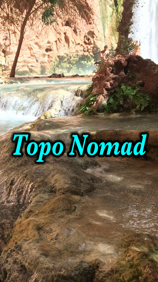
Topo Nomad is designed for road trips, camping, hiking, exploration and geographical history. Map images are accurately center aligned regardless of datum and placed on top of Apple's map kit for easy referencing and intuitive touch navigation.
This software utilizes the latest capabilities of IOS offering the highest performance with fast start up, map rotation, rendering and zoom with unbeatable details and undistorted resolution. Map downloads are dispatched in the background so you can continue using the app while new maps concurrently install.
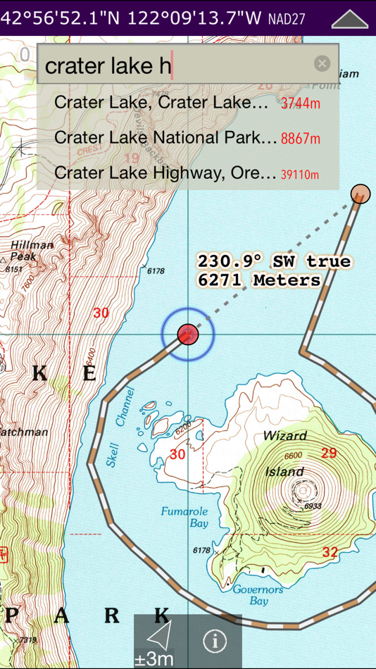
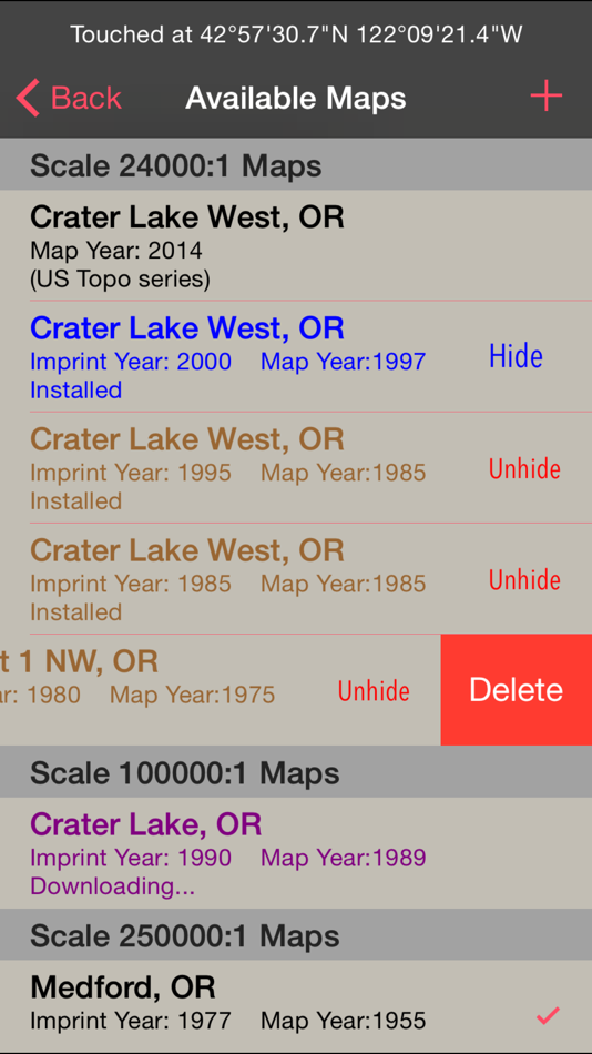
Topo Nomad indexes of over 250,000+ U.S. Geological Survey current and historical topographic maps describing the topography of every region and island territories of the United States of America. Historical versions date as far back as year 1884. Install a map quad by pressing and holding a point on the reference map and discover the USGS historical maps available at that coordinate and the unique names given to every quad by the cartographers.**
The limits don't stop there with just USGS maps. Import "Geospatial PDF" maps from the web, iTunes and email. Many local and national park services offer PDF map downloads from their web sites which automatically install into the Topo Nomad app. And, if you reside outside the United States check with your government services for topographic and aeronautical sectional maps with embedded geospatial metadata.‡
Cannot find that map you downloaded but know where in the world it's located. Simply zoom out the reference map view and all the topo maps become a colorful violet and partially transparent so you can spot your map. Installed maps are managed in a table format which can be sorted by name, distance, and scale. Multiple versions of the same map can be stacked on top of one another and made visible or hidden using two finger swipes.
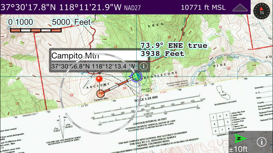
Planning a hike somewhere and want to know the distance of your jaunt. Download the map and use the dual mode ruler to measure the path distance and know the answer to "how much farther?"
Purchase a subscription for unlimited map downloading. A subscription stops ads and doesn't auto-renew. The first few map download are complementary.‡
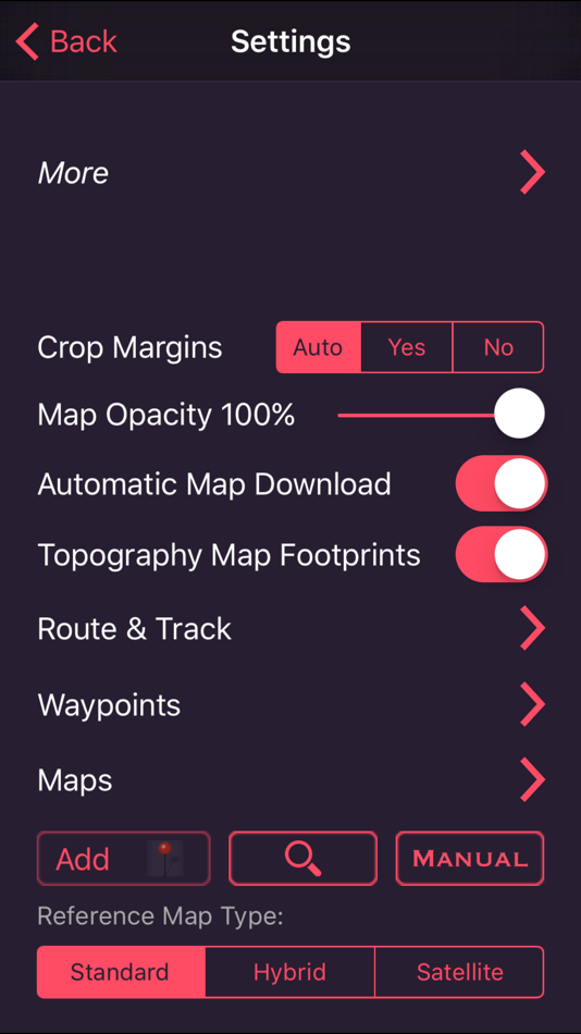
Features:
• No need for cellular service to use maps
• GPS location on downloaded topo maps while offline
• Find geographic features with geocode search
• Track path GPS recording*
• Route paths and distance
• Dual mode ruler with orthographic line and path measuring
• Full app usability while maps download in the background
• Displays footprint grid and quadrangle names
• Aligns all map datums to WGS84 GPS coordinates
• Dynamic map stitching
• Cropping of map margins for one big map grid
• Automatic map download for your current location
• Uses GPS location service to identify your location on a topo map
• Miles, Feet, Kilometers, Meters, Nautical Miles units
• MGRS, UTM and geodetic Latitude and Longitude decimal and minutes seconds coordinate display
• Import maps downloaded from the USGS in zip and PDF file formats
• Import Geospatial PDF map images via a the web, email attachment & iTunes
• MSL elevation for GPS location
• Waypoints with Augmented Reality finder
• Email and SMS text waypoints, tracks and routes as GPX files with subscription purchase
Not currently supported: geo-TIFF; PDF OCG Layers. Not all geospatial datums and metadata formats are supported, please email support with Geospatial PDF issues.
* Continued use of GPS running in the background can dramatically decrease battery life. Location feature may not function on iPod and wifi-only iPad devices without GPS hardware.
** Not preloaded with maps. WiFi recommended. Downloading queue caps to around 36 maps.
‡ After a subscription period expires, advertisement may resume from usage of the import features.
螢幕擷取畫面
新功能
- 版本: 8.1
- 發佈日期:
- • Nice speed improvements.
• New PDF rendering engine that is significantly faster and properly displays the USGS USTopo map series.
• No google advertisements and no trackers.
價錢
- 今天: 免費
- 最小值: 免費
- 最大值: 免費
追蹤票價
開發人員
- Delcartes LLC
- 平台: iOS 應用程式 (4)
- 清單: 0 + 0
- 點數: 0 + 1,181 ¡
- 排名: 0
- 評測: 0
- 折扣: 0
- 影片: 0
- RSS: 訂閱
點數
0 ☹️
排名
0 ☹️
清單
0 ☹️
評測
成為第一個評論 🌟
其他資訊
- 🌟 分享
- App Store
你可能還喜歡
-
- Topo Maps+
- iOS 應用程式: 地圖與導航 由: Glacier Peak Studios LLC
- 免費
- 清單: 0 + 0 排名: 0 評測: 0
- 點數: 0 + 9,046 (4.7) 版本: 9.6.2 Designed and tested on real dirt, Topo Maps+ is packed with the maps & tools to plan and execute your backcountry adventure. MAPS FOR EVERY ACTIVITY Setup your map based on your ... ⥯
-
- Topo Map & Hiking Tracker
- iOS 應用程式: 地圖與導航 由: LW Brands, LLC
- $0.99
- 清單: 0 + 0 排名: 0 評測: 0
- 點數: 0 + 1,346 (4.7) 版本: 1.7 The #1 Hiking Tracker App for iOS TRACK YOUR STATS! + Total distance + Total vertical + Total time + Calories burned * Optimized to save battery life VIEW YOUR TRACKS! + Recap your ... ⥯
-
- Topo maps - Finland
- iOS 應用程式: 地圖與導航 由: Shingle Oy
- $2.99
- 清單: 0 + 0 排名: 0 評測: 0
- 點數: 0 + 2 (4.5) 版本: 3.7.2 The most accurate topo maps for Finland with versatile tools. Accurate maps Topo maps - Finland shows maps for all scales from National Land Survey of Finland. The app benefits Retina ... ⥯
-
- Topo Lock Maps
- iOS 應用程式: 地圖與導航 由: VonCannon Technology
- * 免費
- 清單: 0 + 0 排名: 0 評測: 0
- 點數: 0 + 6 (5.0) 版本: 1.4.1 A mapping app that puts your privacy first. Topo Lock Maps offers end-to-end encryption with no ads, no marketing notifications, no social media integrations, and absolutely no data ... ⥯
-
- Topo Maps
- iOS 應用程式: 地圖與導航 由: Mappendix Limited
- $19.99
- 清單: 0 + 0 排名: 0 評測: 0
- 點數: 0 + 126 (4.3) 版本: 1.19 * View over 70,000 Natural Resources Canada 1:50,000 and USGS 1:24,000 topographical maps on your iPhone or iPod touch. * Ideal for hiking and other backcountry activities. * Map ... ⥯
-
- Topo Maps
- iOS 應用程式: 地圖與導航 由: East Studios Oy
- $2.99
- 清單: 0 + 0 排名: 0 評測: 0
- 點數: 0 + 4 (4.5) 版本: 7.0 Explore nature easily using the Topo Maps app, your ultimate outdoor companion. MAPS Access high-resolution, up-to-date topographic maps for over a dozen countries, including the U.S., ⥯
-
- Topo Maps US
- iOS 應用程式: 地圖與導航 由: DC Cloud Apps, LLC
- 免費
- 清單: 0 + 0 排名: 0 評測: 0
- 點數: 0 + 196 (4.4) 版本: 6.4.1 Download and view topographic maps covering the United States. Topographic maps are useful for recreational activities such as hiking, canoeing, camping, fishing, mountain biking, ... ⥯
-
- Topo Maps by Landscape
- iOS 應用程式: 地圖與導航 由: Landscape, LLC
- * 免費
- 清單: 0 + 0 排名: 0 評測: 0
- 點數: 0 + 75 (4.8) 版本: 2025.1 Summiting a peak is a extraordinary experience, Landscape helps you get there and ensures you never forget it. Whether you re a seasoned mountaineer, an avid peak bagger, or simply ... ⥯
-
- MapToaster NZ Topo Maps
- iOS 應用程式: 地圖與導航 由: Integrated Mapping Ltd
- 免費
- 清單: 0 + 0 排名: 0 評測: 0
- 點數: 0 + 2 (3.5) 版本: 4.0.9 MapToaster for iOS provides New Zealand topo maps with all the rich detail of the LINZ Topo50 and Topo250 topographical maps, helping you plan your expedition and get to the right ... ⥯
-
- iHikeGPS : Classic Topo Maps
- iOS 應用程式: 地圖與導航 由: James Associates Inc.
- $4.99
- 清單: 0 + 0 排名: 0 評測: 0
- 點數: 1 + 58 (4.4) 版本: 9.6.6 Unleash the navigation potential of your iPhone or iPad with iHikeGPS! Turn your device into a high-performance GPS receiver equipped with USGS, US Forest Service & Canadian topo maps. ⥯
-
- Natural Atlas: Topo Maps & GPS
- iOS 應用程式: 地圖與導航 由: Natural Atlas
- 免費
- 清單: 0 + 0 排名: 0 評測: 0
- 點數: 0 + 185 (4.5) 版本: 4.7.1 Natural Atlas is the ultimate map & field companion for your next trip outdoors. Navigate with beautiful and detailed original maps, discover local plants and animals, and build an ... ⥯
-
- Route Scout - GPS Topo Mapper
- iOS 應用程式: 地圖與導航 由: Joseph Bartels
- 免費
- 清單: 0 + 0 排名: 0 評測: 0
- 點數: 0 + 27 (4.3) 版本: 7.2.38 Record outdoor activities: designed for hiking Features Topographic map, waypoints, mileage, elevation, speed, time, moving average, breaks. Audio options for splits, nearby waypoints ... ⥯
-
- TrailTreks: NZ Topo Maps
- iOS 應用程式: 地圖與導航 由: Evgeniy Kobyakov
- 免費
- 清單: 0 + 0 排名: 0 評測: 0
- 點數: 0 + 0 版本: 2.24.11 TrailTreks provides detailed topographic maps of New Zealand, designed specifically for adventurers like you. What makes us different? We focus on offline capability from the ground ... ⥯
-
- NZ Topo Maps
- iOS 應用程式: 地圖與導航 由: Rajan Fernandez
- 免費
- 清單: 0 + 0 排名: 0 評測: 0
- 點數: 0 + 17 (4.2) 版本: 1.9 Offline topographic maps of New Zealand. Topo250 and Topo50 maps direct from the LINZ data service Download just the maps you need and delete the ones you don't to save device storage ... ⥯