| Sviluppatore: | TopoLynx GIS & Mapping Ltd (4) | ||
| Prezzo: | Gratis | ||
| Classificazioni: | 0 | ||
| Recensioni: | 0 Scrivi una recensione | ||
| Listes: | 0 + 0 | ||
| Punti: | 0 + 3 (4.0) ¡ | ||
| App Store | |||
Descrizione
")
• Multiplatform design: the same software with the same rich functionality for both GIS data collectors and Surveyors on iOS & macOS.
• Handling and displaying large spatial datasets (raster and vector).
• Responsive and intuitive user interface: easy to learn and use, automatic adjustment to different screen sizes, orientations, and resolutions of mobile (iPhone, iPad) and desktop devices.
• Online and offline operation: online data sources (Cloud storage, TMS, WMS, KML), offline raster datasets (jpeg, ecw, ers, tiff, png, lan, bil, ENVI bsq), offline vector datasets (shp, dxf, map, GeoJSON, mif, txt, crd, dat, dbf, tab, mid).
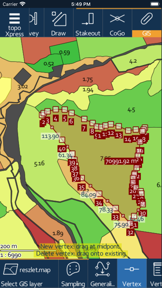
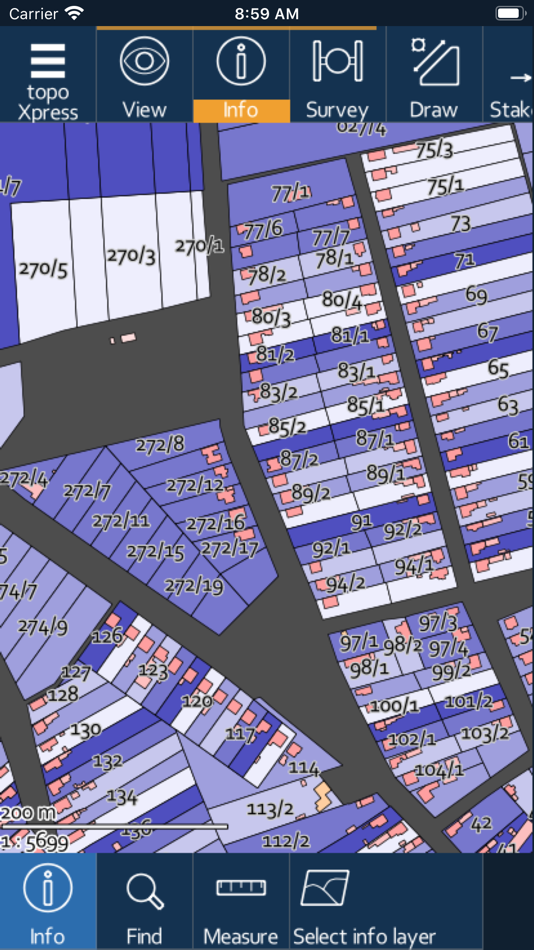
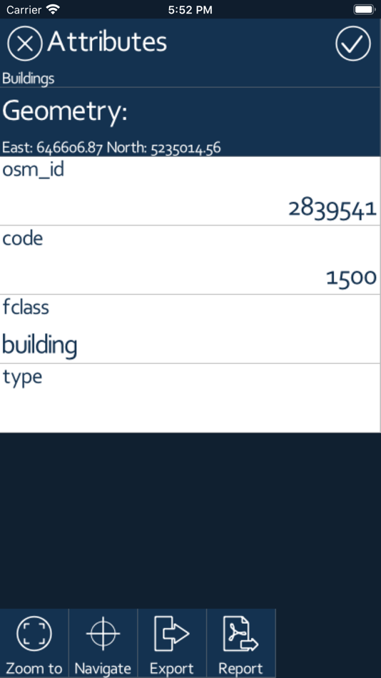
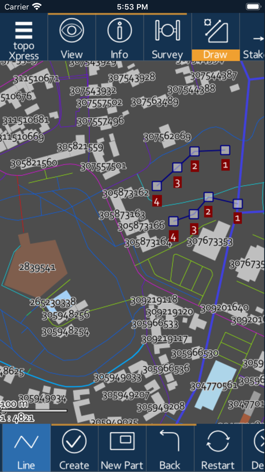
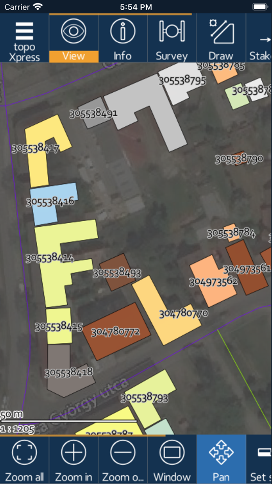
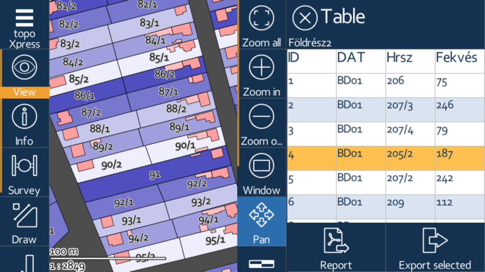
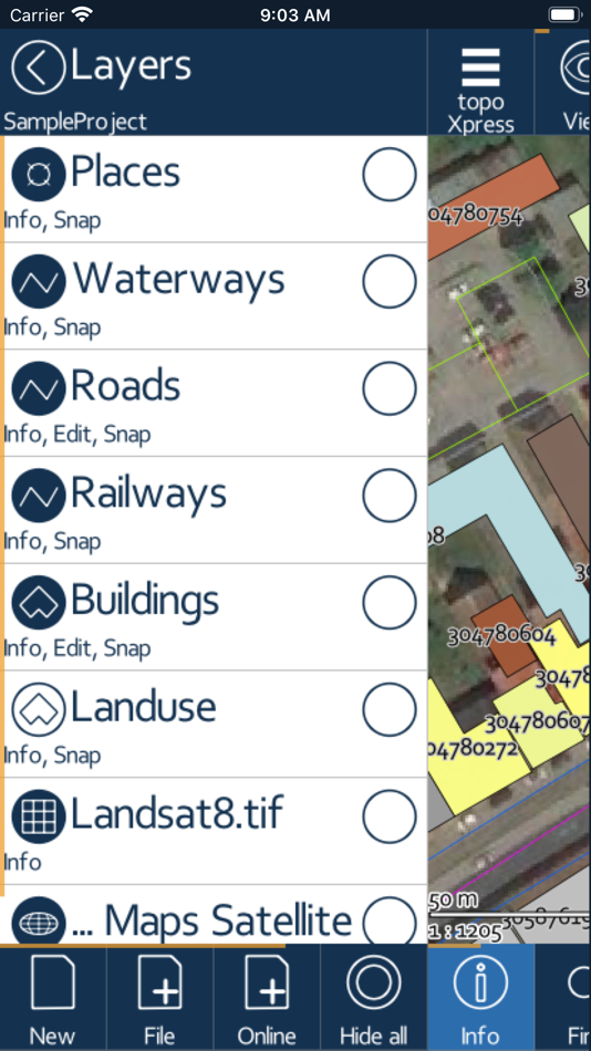
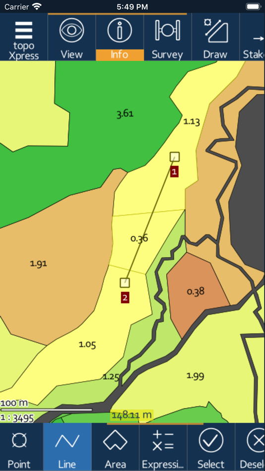
• Powerful GIS visualization functions: thematic mapping, transparency, labeling, query, layer groups, vector symbols, line types, fill types, event mapping.
• Productive data collection: templates, surveying, stakeout, CoGo (Coordinate Geometry), forms, lists, calculated fields, GIS editing functions, sampling tool, and more.
• Collaborative mapping for professional users through the topoXpress cloud service.
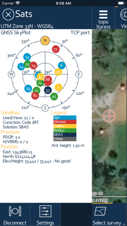
• Extensive support of GNSS receivers through TCP port & Bluetooth, projection systems, geoids, shift grids. Bluetooth Rangefinder support for CoGo tasks.
The app can be used in many different sectors:
• Field data collection and inspection
• Land Surveying
• Topographic mapping
• Forestry
• Farm mapping
• Utility mapping and inspection
• Archeology
*** NOTE: topoXpress offers all specified GIS functions free of charge. However, loading more than 10.000 records, saving and exporting your job can be done through our cloud service. Please visit our website for further details: https://topoXpress.com
**NOTE ON BATTERY USAGE: The app may dramatically decrease battery life during the use with large spatial datasets. The app supports optional background location services, which can may cause a faster battery drain than usual.
Screenshot
Novità
- Versione: 1.3.1
- Aggiornata:
- NEW# 2106 In the data table view, clicking at the start of a record highlights the record's geometry on the map.
NEW# 2114 Topological functions: Run methods like Buffer / Build / Dissolve on a single layer, and Union / Intersection / Difference methods between two layers.
NEW# 2158 Display MGRS coordinates on the Info panel. Input MGRS coordinates on the Input panels.
NEW# 2159 List existing values when typing into a text field with keyword highlighting.
NEW# 2098 Grouped Mount point selection list
NEW# 2072 Group editing of classes display options
NEW# 2060 New option on labeling panel to display distances between vertices
NEW# 2055 Split and merge tools can edit polyline layers
NEW# 2056 New offset values for Emlid antennas
NEW# 1931 Option to synchronize Media file to the Cloud
NEW# 1994 Support for Arduino RTK
NEW# 1991 Direct support for Nautiz X6 RTK
NEW# 1879 Improved feature: in the right “result” list, the geometry of the selected element is flashed - by clicking on its icon. The data table can be opened with the “>” button.
NEW# 1921 South g3 antenna offset value
NEW# 1963 Progress bar in GNSS Port search and in cache delete
NEW# 1987 In the case of date filtering and selection in the attribute panel, you can filter or select values between two selected dates
NEW# 851 Background map cache delete
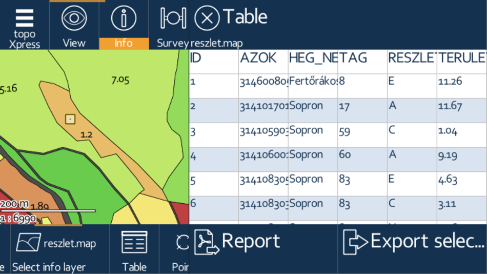
NEW# 1964 Summarize table view. Get aggregated values from a layer’s attribute table, by specifying one row, one column dimension field and a measure field, or one row and many measure fields.
NEW# 1901 WMS Server - GetMap method supported
NEW# 1927 Notification, when the WFS source changed
NEW# 1913 New line types (arrow, contour, etc.) are available, and tool for flipping lines.
NEW# 1909 A description can be specified for each field that can be checked on the record panel
NEW# 1904 New raster DEM and near infrared image display modes. New tool to create raster profiles. Calculate raster statistics (Min, Max, Avg, Sum, Dev) within a polygon.
NEW# 1749 Redesigning of cloud access usage. The required cloud access can be given back in any time so the user can continue the work on an other device immediately
NEW# 1818 New options for generating buffer: Bands only, and main part only
NEW# 1807 Attribute table view improvements. Introducing new field context menus for sorting, selecting, filtering, calculation and displaying of chart on field values
NEW# 1833 COGO panel improvements when laser rangefinder is in use
NEW# 1895 Support of WFS layers usage
NEW# 1787 Vertex numbers checkbox in Report menu
NEW# 1772 Displaying the layer's objects number
NEW# 1755 GNSS survey offset
NEW# 1320 Confirmation question, before drop GNSS collected geometry
NEW# 1746 Vertex GNSS resurveying
NEW# 1729 Erase objects function/button into GIS tools
NEW# 1769 Table view: sort objects (only ascending) by field
NEW# 1652 Datum transformation when exporting layer
NEW# 1793 Buffer option: skip inner rings
NEW# 1756 Merging vector layers
NEW# 1449 Improved map rendering engine: faster vector drawing
NEW# 1725 Project directory quick link to the layers menu
NEW# 1707 Simple raster orientation - affine raster transformation based on 3 controlpoints.
NEW# 1697 Divide are along a splitting line, with the following options: 1- given number, 2- areas of the same size, 3-by given areas, 4-by ratios.
NEW# 1696 Create ZIP archive from 'Export layer' function's result files.
NEW# 1680 3 label field can be selected. One of the following separator character can be specified between label fields: line break, space, comma, hyphen, slash, vertical bar.
Prezzo
- Oggi: Gratis
- Minimo: Gratis
- Massimo: Gratis
Monitora prezzi
Sviluppatore
- TopoLynx GIS & Mapping Ltd
- Piattaforme: Android App (3) iOS App (1)
- Listes: 0 + 0
- Punti: 0 + 3 ¡
- Classificazioni: 0
- Recensioni: 0
- Sconti: 0
- Video: 1
- RSS: Sottoscrivi
Punti
0 ☹️
Classificazioni
0 ☹️
Listes
0 ☹️
Recensioni
Scrivi tu la prima recensione 🌟
Informazioni aggiuntive
- Versione: 1.3.1
- Categoria:
iOS App›Navigazione - Sistemi operativi:
iPad,iPhone,iOS 17.5 e versioni successive - Dimensioni:
27 Mb - Lingue supportate:
English - Classificazione contenuti:
4+ - App Store Voto:
4.0(3) - Aggiornata:
- Data di uscita:
Contatti
- Sito web:
 https://topoxpress.com
- 🌟 Condividi
- App Store
Ti potrebbero piacere anche
-
- Topo Maps+
- iOS App: Navigazione di: Glacier Peak Studios LLC
- * Gratis
- Listes: 0 + 0 Classificazioni: 0 Recensioni: 0
- Punti: 0 + 9,024 (4.7) Versione: 9.6.1 Designed and tested on real dirt, Topo Maps+ is packed with the maps & tools to plan and execute your backcountry adventure. MAPS FOR EVERY ACTIVITY Setup your map based on your ... ⥯
-
- Topo Map & Hiking Tracker
- iOS App: Navigazione di: LW Brands, LLC
- $0.99
- Listes: 0 + 0 Classificazioni: 0 Recensioni: 0
- Punti: 0 + 1,345 (4.7) Versione: 1.7 The #1 Hiking Tracker App for iOS TRACK YOUR STATS! + Total distance + Total vertical + Total time + Calories burned * Optimized to save battery life VIEW YOUR TRACKS! + Recap your ... ⥯
-
- Topo maps - Finland
- iOS App: Navigazione di: Shingle Oy
- $2.99
- Listes: 0 + 0 Classificazioni: 0 Recensioni: 0
- Punti: 0 + 2 (4.5) Versione: 3.7.2 The most accurate topo maps for Finland with versatile tools. Accurate maps Topo maps - Finland shows maps for all scales from National Land Survey of Finland. The app benefits Retina ... ⥯
-
- Topo Lock Maps
- iOS App: Navigazione di: VonCannon Technology
- * Gratis
- Listes: 0 + 0 Classificazioni: 0 Recensioni: 0
- Punti: 0 + 6 (5.0) Versione: 1.4.1 A mapping app that puts your privacy first. Topo Lock Maps offers end-to-end encryption with no ads, no marketing notifications, no social media integrations, and absolutely no data ... ⥯
-
- Topo Maps
- iOS App: Navigazione di: Mappendix Limited
- $19.99
- Listes: 0 + 0 Classificazioni: 0 Recensioni: 0
- Punti: 0 + 126 (4.3) Versione: 1.19 * View over 70,000 Natural Resources Canada 1:50,000 and USGS 1:24,000 topographical maps on your iPhone or iPod touch. * Ideal for hiking and other backcountry activities. * Map ... ⥯
-
- Topo Maps
- iOS App: Navigazione di: East Studios Oy
- $2.99
- Listes: 0 + 0 Classificazioni: 0 Recensioni: 0
- Punti: 0 + 4 (4.5) Versione: 7.0 Explore nature easily using the Topo Maps app, your ultimate outdoor companion. MAPS Access high-resolution, up-to-date topographic maps for over a dozen countries, including the U.S., ⥯
-
- Topo Maps US
- iOS App: Navigazione di: DC Cloud Apps, LLC
- Gratis
- Listes: 0 + 0 Classificazioni: 0 Recensioni: 0
- Punti: 0 + 195 (4.4) Versione: 6.4.1 Download and view topographic maps covering the United States. Topographic maps are useful for recreational activities such as hiking, canoeing, camping, fishing, mountain biking, ... ⥯
-
- Topo Maps by Landscape
- iOS App: Navigazione di: Landscape, LLC
- * Gratis
- Listes: 0 + 0 Classificazioni: 0 Recensioni: 0
- Punti: 0 + 75 (4.8) Versione: 2025.1 Summiting a peak is a extraordinary experience, Landscape helps you get there and ensures you never forget it. Whether you re a seasoned mountaineer, an avid peak bagger, or simply ... ⥯
-
- MapToaster NZ Topo Maps
- iOS App: Navigazione di: Integrated Mapping Ltd
- Gratis
- Listes: 0 + 0 Classificazioni: 0 Recensioni: 0
- Punti: 0 + 2 (3.5) Versione: 4.0.9 MapToaster for iOS provides New Zealand topo maps with all the rich detail of the LINZ Topo50 and Topo250 topographical maps, helping you plan your expedition and get to the right ... ⥯
-
- iHikeGPS : Classic Topo Maps
- iOS App: Navigazione di: James Associates Inc.
- $4.99
- Listes: 0 + 0 Classificazioni: 0 Recensioni: 0
- Punti: 1 + 58 (4.4) Versione: 9.6.6 Unleash the navigation potential of your iPhone or iPad with iHikeGPS! Turn your device into a high-performance GPS receiver equipped with USGS, US Forest Service & Canadian topo maps. ⥯
-
- Natural Atlas: Topo Maps & GPS
- iOS App: Navigazione di: Natural Atlas
- Gratis
- Listes: 0 + 0 Classificazioni: 0 Recensioni: 0
- Punti: 0 + 185 (4.5) Versione: 4.7.1 Natural Atlas is the ultimate map & field companion for your next trip outdoors. Navigate with beautiful and detailed original maps, discover local plants and animals, and build an ... ⥯
-
- Route Scout - GPS Topo Mapper
- iOS App: Navigazione di: Joseph Bartels
- Gratis
- Listes: 0 + 0 Classificazioni: 0 Recensioni: 0
- Punti: 0 + 27 (4.3) Versione: 7.2.18 Record outdoor activities: designed for hiking Features Topographic map, waypoints, mileage, elevation, speed, time, moving average, breaks. Audio options for splits, nearby waypoints ... ⥯
-
- TrailTreks: NZ Topo Maps
- iOS App: Navigazione di: Evgeniy Kobyakov
- Gratis
- Listes: 0 + 0 Classificazioni: 0 Recensioni: 0
- Punti: 0 + 0 Versione: 2.20.4 TrailTreks provides detailed topographic maps of New Zealand, designed specifically for adventurers like you. What makes us different? We focus on offline capability from the ground ... ⥯
-
- DGMobi US Xpress
- iOS App: Navigazione di: Ideabytes
- * Gratis
- Listes: 0 + 0 Classificazioni: 0 Recensioni: 0
- Punti: 0 + 0 Versione: 4.2.1 Who is the app best suited for: Trucker and courier drivers that pick up and deliver hazmat loads. Why? - Ensure compliance with 49 CFR when hauling HAZMAT you re responsible for every ⥯