| Udvikler: | Daniel Tekel (4) | ||
| Pris: | * Gratis | ||
| Rangeringer: | 0 | ||
| Anmeldelser: | 0 Skriv en anmeldelse | ||
| Lister: | 0 + 0 | ||
| Point: | 0 + 0 ¡ | ||
| App Store | |||
Beskrivelse
")
App's main features:
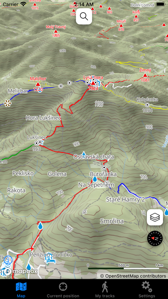
- displaying the current position on the map,
- 3D map display,
- hybrid satellite map,
- cycling map,
- your track recording,
- search on the map (requires an Internet connection),
- indicator of the iPhone's current orientation,
- GPS coordinates, altitude and GPS accuracy display,
- recorded tracks' statistics - distance covered, time, elevation gain,
- tracks height profiles rendering,
- recorded tracks are saved in GPX format and can be easily transferred to computer,
- track recording automatic shutdown after a specified time (e.g. 2 hours),
- track recording automatic shutdown if the battery level drops below a certain level,
- GPS accuracy setting (lower accuracy extends battery life),
- custom scaling for texts in the map (scale factor set in app's settings).
Map in this application was generated based on data from the OpenStreetMap project and this data is under (c) OpenStreetMap contributors. Map design and tiles are under (c) Daniel Tekel.
Important notice: The map in this application does not contain all existing hiking trails and points (currently covers approximately 90% of all trail)! For this reason, this application certainly cannot substitute an official hiking map. The author of the application assumes no responsibility for inaccuracies in the map. Terms of use of the app: https://www.apple.com/legal/internet-services/itunes/dev/stdeula/. Privacy Policy: https://turistickamapa.com/iOSPrivacyPolicy.html.
Skærmbilleder


Nyheder
- Version: 3.3
- Opdateret:
- - new cycling map,
- improved map design,
- map data update,
- bugfixes
Pris
-
* Indkøb i appen - I dag: Gratis
- Minimum: Gratis
- Maksimalt: Gratis
Overvåg priser
Udvikler
- Daniel Tekel
- Platforme: iOS Apps (4)
- Lister: 0 + 0
- Point: 0 + 6 ¡
- Rangeringer: 0
- Anmeldelser: 0
- Rabatter: 0
- Videoer: 0
- RSS: Abonner
Point
0 ☹️
Rangeringer
0 ☹️
Lister
0 ☹️
Anmeldelser
Vær den første til at gennemgå 🌟
Yderligere oplysninger
- 🌟 Del
- App Store
Du vil måske også kunne lide
-
- Turistická Mapa SR
- iOS Apps: Navigation Ved: Daniel Tekel
- Gratis
- Lister: 0 + 0 Rangeringer: 0 Anmeldelser: 0
- Point: 0 + 3 (5.0) Version: 3.3 This application displays a detailed offline topographical map of Slovak Republic with hiking trails, cycling paths, points of interest, peaks, hills, etc. You can view it in 2D and 3D ⥯
-
- mIBS - ANS Czech Republic
- iOS Apps: Navigation Ved: FREQUENTIS California Inc.
- Gratis
- Lister: 0 + 0 Rangeringer: 0 Anmeldelser: 0
- Point: 0 + 0 Version: 6.1.1 Mobile IBS - an ANS CR application for the pre-flight preparation of IFR and VFR flights. mIBS is a user friendly application for the pre-flight preparation of IFR and VFR flights, ... ⥯
-
- Live Street View - Maps
- iOS Apps: Navigation Ved: BUSINESS SOLUTIONS INTERNATIONAL (PRIVATE) LIMITED
- * Gratis
- Lister: 0 + 0 Rangeringer: 0 Anmeldelser: 0
- Point: 0 + 4 (1.8) Version: 1.2.5 Embark on a captivating journey of discovery with Live Street View. This gps navigation revolutionizes the way you explore the world, offering an immersive and interactive experience ... ⥯
-
- Relaid
- iOS Apps: Navigation Ved: ReK2
- Gratis
- Lister: 0 + 0 Rangeringer: 0 Anmeldelser: 0
- Point: 0 + 718 (4.6) Version: 3.0.7 Relaid is one of the largest real-time information services that processes reports of police activity and other traffic related incidents. Join Relaid to share and receive ... ⥯
-
- PanaTag
- iOS Apps: Navigation Ved: Rastreo GPS Panama SA
- Gratis
- Lister: 0 + 0 Rangeringer: 0 Anmeldelser: 0
- Point: 0 + 0 Version: 3.0.27 PanaTag es la aplicación que permite convertir un dispositivo móvil en un rastreador GPS. PanaTag es compatible con los sistemas de rastreo satelital GPS y GLONASS Wialon Hosting y ... ⥯
-
- NaviPŁ
- iOS Apps: Navigation Ved: Politechnika Łódzka
- Gratis
- Lister: 0 + 0 Rangeringer: 0 Anmeldelser: 0
- Point: 0 + 0 Version: 1.0.2 The NaviPŁ application is a great convenience in moving around open areas and buildings of campuses A, B and C of the Lodz University of Technology. The system offers search services ... ⥯