| 개발자: | seawellsoft (4) | ||
| 가격: | 무료 | ||
| 순위: | 0 | ||
| 리뷰: | 0 리뷰 작성 | ||
| 목록: | 0 + 0 | ||
| 포인트: | 1 + 10 (1.3) ¡ | ||
| App Store | |||
기술
")
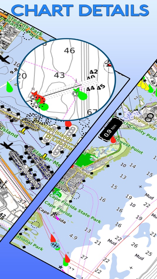
***Ability to Zoom and Pan : Our App has a new feature for intuitive waypoint and route management. You can store and retrieve the real-time markers and favorite waypoints on water. You can zoom and pan effortlessly. Can mark or add favorite spots, dynamically without going back and forth to the chart.
***Purchase of this app includes online maps and a low detailed offline world map. Further, downloading of detailed charts is possible after purchasing through In-App map store provided in the application.
BA Steinhagen - Martin Dies SP
Connecticut Lakes
Candlewood Lake
Cayuga and Seneca Lakes
Lake Champlain & Adirondack NP
Chickamauga Lake
Delaware Lakes
Lake Duck and Huntersville SF
Erie Basin Lake
Fort Gibson Lake
Lake George and Ocala NF
Grand Lake O Cherokees
Granger Lake & Willis Creek
Grant Lake & Mississippi HW
Gull Lake Pilsbury SF
Guntersville Lake
Houston Lake
Hudson Lake
Huron Lake
Indiana Lakes
IOWA Lakes
Island Lake and Cloquet trails
Itasca Lake and Park Trails
Lake Joe Pool & Cedar Hill SP
Kentucky and Barkley Lakes
Lake Audubon
Lake Norman
Lake Of the Woods
Lake Sakakawea
Lake Sidney Lanier
Lake Saint Clair
Lake Texoma
Lake Tohopekaliga
Lake Winnebago
Lake Winnipesaukee
Leech,Winnibigoshish&Chippewa
Lillinonah Lake
LivingStone,Conroe&Sam Houston
Macbride Lake
Mantrap,Kabekona&Paul Bunyan
Lake Mead and Grand Canyon NP
Michigan Lake
Mille Lacs Lake
Minnetonka Lake
Murray Lake
New Hampshire Lakes
North Dakota Lakes
Oklahoma Lakes
Old Hickory Lake
Ontario Lake
Pat Mayse Lake
Pine Mountain & Foot Hill SF
Pokegama lake and Golden Anniversary
Lake Powell and Glen Canyon
Ray Roberts Lake and SP
Saginaw Bay
Sam Rayburn RSVR & Angelina NF
Serpent Lake and Cuyuna trails
Superior Lake
Toledo Bend RSVR & Sabine NF
Lake of the Ozarks
Two Inlets Lake and SF
Washington Lakes
YellowStone Lake and NP
FEATURES:
* Marker : locations can be marked and you can share easily favorite locations with friends and family.
* KMZ : To send your favorite coordinate through e-mail.
* Track: Records your path, and stores the details.
* Measure: Distance can be calculated easily.
* GPS: Location and heading on map.
*Seawell apps can be used in offline mode.
*Seawell has multiple overlays: Offline, Hybrid, Street mode ,Topo
*Offline: Only offline maps will be displayed which are useful in situations where there is no Internet connectivity. .
*Hybrid: Land areas are covered by satellite imagery.
*Street: Land areas are covered by open street maps.
* Topo : Land areas are covered by topographic maps
*Seawell strives to provide user-friendly apps.
***NOTE: "Continued use of GPS running in the background can decrease battery life”
“Turn off GPS when not in use”
스크린샷


가격
- 오늘: 무료
- 최소: 무료
- 최대: $1.99
가격 추적
개발자
- seawellsoft
- 플랫폼: iOS 앱 (4)
- 목록: 0 + 0
- 포인트: 3 + 26 ¡
- 순위: 0
- 리뷰: 0
- 할인: 0
- 동영상: 0
- RSS: 구독
포인트
-

- 2,206 Mario Green
- +1

순위
0 ☹️
목록
0 ☹️
리뷰
첫 번째 리뷰를 남겨보세요 🌟
추가 정보
주소록
- 웹사이트:
 http://seawellsoft.com
- 🌟 공유하기
- App Store
당신은 또한 같은 수 있습니다
-
- Allegheny County Parks Trails
- iOS 앱: 내비게이션 게시자: Allegheny County
- 무료
- 목록: 0 + 0 순위: 0 리뷰: 0
- 포인트: 0 + 1 (5.0) 버전: 5.1.11 FEATURES Explore Every Allegheny County Park: Discover the beauty and diversity in each of the nine Allegheny County Parks. Navigate Trails with GPS Precision: Utilize GPS technology ... ⥯
-
- Trails Offroad: Offline Maps
- iOS 앱: 내비게이션 게시자: TRAILS OFFROAD LLC
- 무료
- 목록: 0 + 0 순위: 0 리뷰: 0
- 포인트: 2 + 566 (4.7) 버전: 3.6.1 Explore with Confidence. Go Beyond the Pavement. Trails Offroad is the #1 app for discovering, planning, and navigating off-road adventures whether you're behind the wheel of a Jeep, ... ⥯
-
- USA Traffic Cameras
- iOS 앱: 내비게이션 게시자: Pavel Koyushev
- 무료
- 목록: 0 + 0 순위: 0 리뷰: 0
- 포인트: 0 + 11 (2.7) 버전: 2.4.6 USA Traffic Cameras gives you instant, live access to thousands of traffic and road condition cameras across the United States. Whether you're planning your commute, heading out on a ... ⥯
-
- USA Cab Ads
- iOS 앱: 내비게이션 게시자: The Web Addicts
- 무료
- 목록: 0 + 0 순위: 0 리뷰: 0
- 포인트: 0 + 0 버전: 2.0.6 USA Cab Ads is a specific tool for our client to monitor and track their current live ads. We provide a modern and effective outdoor advertising media channel, to our valued clients ... ⥯
-
- Collie Wambenger Trails
- iOS 앱: 내비게이션 게시자: Government of Western Australia - Department of Parks and Wildlife
- 무료
- 목록: 0 + 0 순위: 0 리뷰: 0
- 포인트: 0 + 0 버전: 9.0.376 Located in South West Western Australia, Wambenger Trails offer mountain biking, walking and paddling trails, camping and water sports. This app is your go to guide for discovering all ⥯
-
- Bay Ridge Trails
- iOS 앱: 내비게이션 게시자: Bay Ridge Civic Association
- 무료
- 목록: 0 + 0 순위: 0 리뷰: 0
- 포인트: 0 + 5 (3.6) 버전: 1.1.1 The Bay Ridge Trails App is a hiking trail app that uses GPS to map out Bay Ridge trails. Users can use the app to find the trails and navigate around Bay Ridge. The app provides a ... ⥯
-
- As-Salt Walking Trails
- iOS 앱: 내비게이션 게시자: Llama Digital
- 무료
- 목록: 0 + 0 순위: 0 리뷰: 0
- 포인트: 0 + 0 버전: 1.0 Soak in the beauty of As-Salt and experience this magical town by taking a walking trail. These self-guided trails will give you an authentic experience of life in the town, and take ... ⥯
-
- Wikiloc - Trails of the World
- iOS 앱: 내비게이션 게시자: Wikiloc Outdoor SL
- 무료
- 목록: 0 + 0 순위: 0 리뷰: 0
- 포인트: 0 + 4,901 (4.8) 버전: 3.25.8 Discover millions of outdoor trails around the world. Choose between hiking, running, bike, MTB, kayak, ski or up to 80 different types of activities. Record your own routes on a map, ... ⥯
-
- Park City Trails
- iOS 앱: 내비게이션 게시자: ECO Systems
- 무료
- 목록: 0 + 0 순위: 0 리뷰: 0
- 포인트: 0 + 0 버전: 2024.9.8 Park City Trails allows you to see all of the summer and winter trails available in Park City (no more need of multiple apps). You can explore and discover trails, whether you have ... ⥯
-
- Topographic Maps & Trails
- iOS 앱: 내비게이션 게시자: LW Brands, LLC
- $4.99
- 목록: 1 + 0 순위: 0 리뷰: 0
- 포인트: 1 + 2,771 (4.6) 버전: 1.6 DOWNLOAD ALL MAPS FOR OFFLINE USE MAIN FEATURES INCLUDE: - USGS Topographic Maps - Satellite + Topo Maps - Hiking Tracker USGS TOPO MAP USGS Topo is a tile cache base map service that ... ⥯
-
- Art Trails
- iOS 앱: 내비게이션 게시자: Jonathan McKenna
- * 무료
- 목록: 0 + 0 순위: 0 리뷰: 0
- 포인트: 1 + 2 (2.5) 버전: 1.1.0 Turn Your Movement Into GPS Art Whether you re running city streets, walking in nature, cycling quiet roads, or paddling open water, Art Trails helps you transform your routes into ... ⥯
-
- GNodeTo: Toronto Trails Map
- iOS 앱: 내비게이션 게시자: QI.AI Inc
- 무료
- 목록: 0 + 0 순위: 0 리뷰: 0
- 포인트: 5 + 0 버전: v1.1.13 GnodeTo is your go-to app for planning and tracking biking or hiking trips in the Great Toronto Area (GTA). Whether you're an experienced adventurer or just starting out, GnodeTo makes ⥯
-
- iSailGPS : NOAA USA RNC Charts
- iOS 앱: 내비게이션 게시자: James Associates Inc.
- $7.99
- 목록: 0 + 0 순위: 0 리뷰: 0
- 포인트: 0 + 71 (3.9) 버전: 9.6.6 Unleash the navigation potential of your iPhone or iPad with SailGPS! Turn your device into a high-performance GPS receiver with USA NOAA Raster Nautical Charts, even without a cell ... ⥯
-
- BLM Public Lands Map Guide USA
- iOS 앱: 내비게이션 게시자: GeoPOI LLC
- $2.99
- 목록: 0 + 0 순위: 0 리뷰: 0
- 포인트: 0 + 4 (4.0) 버전: 3.0.2 The United States of America is a vast land full of lush forests, stunning deserts, indescribable landscapes, and fascinating history. You may already know some of the iconic landmarks ⥯