| 開發人員: | Walk About Apps (5) | ||
| 價錢: | 免費 | ||
| 排名: | 0 | ||
| 評測: | 0 寫評論 | ||
| 清單: | 0 + 0 | ||
| 點數: | 0 + 1 (4.0) ¡ | ||
| App Store | |||
描述
")
Statewide USGS topographic maps are stored on your device, so go ahead and turn on airplane mode to extend battery life and boot up the GPS only when you need it to pinpoint your location.
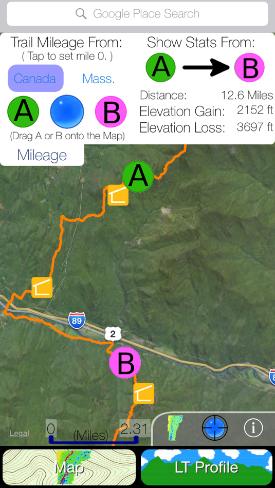
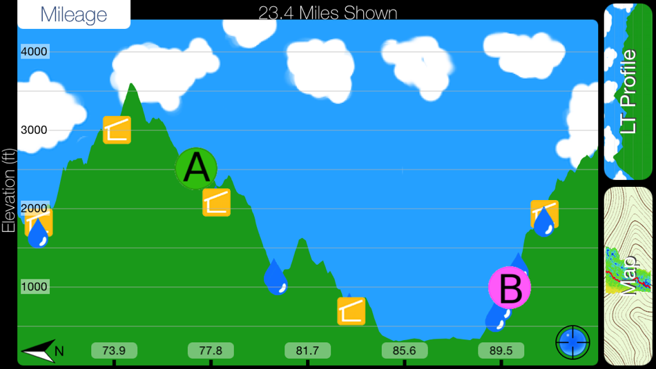
The convenient mileage menu calculates distance between any two points on the map and integrates with an interactive profile graph of the Long Trail to show elevation gain/loss over Vermont’s highest peaks.
Detailed List of Features:
Statewide:
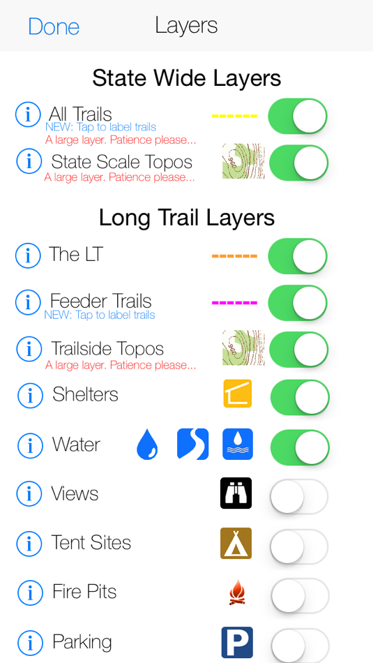
-Statewide USGS topographic maps stored on your phone. No cell coverage needed!
-Over 2,000 labeled hiking, walking and biking trails.
-A mileage calculator for trip planning.
-Place search powered by Google.
Long Trail Focused:
-A highly detailed track of Vermont's longest hiking trail.
-Super high detail USGS topographic maps (1:24,000 scale) flanking the trail.
-A trail mileage and elevation calculator.
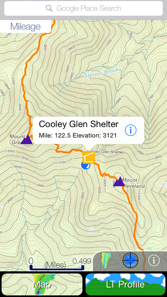
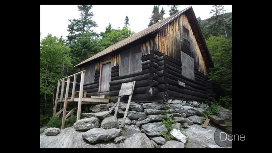
-Shelters, official and unofficial, with descriptive photos.
-An interactive profile view showing elevation, trail intersections and points of interest.
-100+ water sources categorized as rivers, streams and ponds.
-Hundreds more waypoints including: tent sights, views, fire pits, parking, summits, towers and gaps.
A selection of over 50 major side trails accessing the LT can be added to the map with the flick of a switch, guiding you with ease to the most scenic locations in Vermont.
Any stream near the LT and big enough to wedge the mouth of your water bottle into has been marked to keep through hikers informed and hydrated.
65 trailside shelters, ski lodges and shacks have been included with descriptive photos and shelters subject to midsummer fees are labeled as such.
螢幕擷取畫面
新功能
- 版本: 2.3
- 發佈日期:
- This app has been updated by Apple to display the Apple Watch app icon.
-A new look for iOS 8.
-Bug fixes and usability improvements.
價錢
- 今天: 免費
- 最小值: 免費
- 最大值: 免費
追蹤票價
開發人員
- Walk About Apps
- 平台: iOS 應用程式 (5)
- 清單: 0 + 0
- 點數: 0 + 50 ¡
- 排名: 0
- 評測: 0
- 折扣: 0
- 影片: 0
- RSS: 訂閱
點數
0 ☹️
排名
0 ☹️
清單
0 ☹️
評測
成為第一個評論 🌟
其他資訊
- 版本: 2.3
- 類別 :
iOS 應用程式›地圖與導航 - OS:
Apple Watch,iPad,iPhone,iOS 8.0 以上版本 - 大小:
85 Mb - 支援的語言 :
English - 內容分級:
4+ - App Store 評分:
4.0(1) - 發佈日期:
- 發行日期:
聯絡人
- 🌟 分享
- App Store
你可能還喜歡
-
- Trails Offroad: Offline Maps
- iOS 應用程式: 地圖與導航 由: TRAILS OFFROAD LLC
- 免費
- 清單: 0 + 0 排名: 0 評測: 0
- 點數: 2 + 597 (4.7) 版本: 3.6.3 Explore with Confidence. Go Beyond the Pavement. Trails Offroad is the #1 app for discovering, planning, and navigating off-road adventures whether you're behind the wheel of a Jeep, ... ⥯
-
- VT VAST Snowmobile Trails
- iOS 應用程式: 地圖與導航 由: MapGears inc.
- 免費
- 清單: 0 + 0 排名: 0 評測: 0
- 點數: 1 + 126 (4.4) 版本: 2.0.11 Out exploring on your snowmobile? Take your own mobile trail assistant for the ride! **NEW THIS SEASON** Track your trips: leave breadcrumbs for easier backtracking, get statistics on ... ⥯
-
- Locator VT
- iOS 應用程式: 地圖與導航 由: Locator CJSC
- 免費
- 清單: 0 + 0 排名: 0 評測: 0
- 點數: 0 + 0 版本: 1.13 Locator VT is Vehicle Tracking System, which works with https://service login.locator.am ⥯
-
- Bay Ridge Trails
- iOS 應用程式: 地圖與導航 由: Bay Ridge Civic Association
- 免費
- 清單: 0 + 0 排名: 0 評測: 0
- 點數: 0 + 5 (3.6) 版本: 1.1.1 The Bay Ridge Trails App is a hiking trail app that uses GPS to map out Bay Ridge trails. Users can use the app to find the trails and navigate around Bay Ridge. The app provides a ... ⥯
-
- As-Salt Walking Trails
- iOS 應用程式: 地圖與導航 由: Llama Digital
- 免費
- 清單: 0 + 0 排名: 0 評測: 0
- 點數: 0 + 0 版本: 1.0 Soak in the beauty of As-Salt and experience this magical town by taking a walking trail. These self-guided trails will give you an authentic experience of life in the town, and take ... ⥯
-
- Wikiloc - Trails of the World
- iOS 應用程式: 地圖與導航 由: Wikiloc Outdoor SL
- 免費
- 清單: 0 + 0 排名: 0 評測: 0
- 點數: 0 + 4,935 (4.8) 版本: 3.25.10 Discover millions of outdoor trails around the world. Choose between hiking, running, bike, MTB, kayak, ski or up to 80 different types of activities. Record your own routes on a map, ... ⥯
-
- Park City Trails
- iOS 應用程式: 地圖與導航 由: ECO Systems
- 免費
- 清單: 0 + 0 排名: 0 評測: 0
- 點數: 0 + 0 版本: 2024.9.8 Park City Trails allows you to see all of the summer and winter trails available in Park City (no more need of multiple apps). You can explore and discover trails, whether you have ... ⥯
-
- Topographic Maps & Trails
- iOS 應用程式: 地圖與導航 由: LW Brands, LLC
- $4.99
- 清單: 1 + 0 排名: 0 評測: 0
- 點數: 1 + 2,778 (4.6) 版本: 1.6 DOWNLOAD ALL MAPS FOR OFFLINE USE MAIN FEATURES INCLUDE: - USGS Topographic Maps - Satellite + Topo Maps - Hiking Tracker USGS TOPO MAP USGS Topo is a tile cache base map service that ... ⥯
-
- GNodeTo: Toronto Trails Map
- iOS 應用程式: 地圖與導航 由: QI.AI Inc
- 免費
- 清單: 0 + 0 排名: 0 評測: 0
- 點數: 5 + 0 版本: v1.1.13 GnodeTo is your go-to app for planning and tracking biking or hiking trips in the Great Toronto Area (GTA). Whether you're an experienced adventurer or just starting out, GnodeTo makes ⥯
-
- OnPoint Trails: OHV Trail Map
- iOS 應用程式: 地圖與導航 由: Brenda Leon
- * 免費
- 清單: 0 + 0 排名: 0 評測: 0
- 點數: 0 + 12 (4.7) 版本: 1.3 OnPoint Trails: Your Ultimate Offline Off-Road Navigator Discover the freedom of off-roading with OnPoint Trails, the all-in-one app designed for adventurers who seek to explore CA OHV ⥯
-
- Art Trails
- iOS 應用程式: 地圖與導航 由: Jonathan McKenna
- * 免費
- 清單: 0 + 0 排名: 0 評測: 0
- 點數: 1 + 2 (2.5) 版本: 1.1.0 Turn Your Movement Into GPS Art Whether you re running city streets, walking in nature, cycling quiet roads, or paddling open water, Art Trails helps you transform your routes into ... ⥯
-
- Bread Crumbs Trails
- iOS 應用程式: 地圖與導航 由: YOURFULLSTACK, LLC
- $1.99
- 清單: 0 + 0 排名: 0 評測: 0
- 點數: 3 + 3 (4.7) 版本: 2.3.3 Bread Crumbs Trail is a location pinging app. All location data is stored within the app and stored on your local device. App is designed for educational research, fun, recreation, ... ⥯
-
- TrailAware: Bike & Hike Trails
- iOS 應用程式: 地圖與導航 由: TrailAware, Inc.
- 免費
- 清單: 0 + 0 排名: 0 評測: 0
- 點數: 0 + 31 (5.0) 版本: 2.6 Experience a groundbreaking way to discover and view all types of trails with TrailAware. Powered by our patented dynamic geospatial mapping technology, TrailAware provides the ... ⥯
-
- Bell Mountain Ranch Trails
- iOS 應用程式: 地圖與導航 由: Sean Molloy
- 免費
- 清單: 0 + 0 排名: 0 評測: 0
- 點數: 0 + 3 (4.7) 版本: 1.51 The BMR Trails app helps users of the BMR trail system to navigate the trails with ease. Your current location is shown on a satellite map of the trail system, with every trail marked ... ⥯