| 開發人員: | Droneguru Servicios Aereos SL (1) | ||
| 價錢: | 免費 | ||
| 排名: | 0 | ||
| 評測: | 0 寫評論 | ||
| 清單: | 0 + 0 | ||
| 點數: | 0 + 1 (5.0) ¡ | ||
| App Store | |||
描述
")
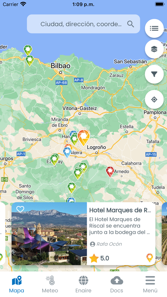
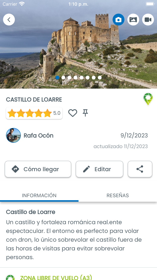
1. Mapa mundial colaborativo de spots en los que se puede volar drones de forma legal sin necesidad de permisos y con descripciones detalladas de los spots: fotos, panorámica, vídeo, ubicación, tipo de dron aconsejado, mejor época para volar ahí, obstáculos o precauciones, posibles riesgos, cómo llegar, características, entorno, punto de despegue ideal...etc.
2. Mapa oficial de ENAIRE para ver las zonas restringidas de vuelo en España y los contactos administrativos para solicitar los permisos.
3. Herramienta de meteorología enfocada al vuelo de drones con predicciones de hasta 15 días con datos cómo: Clima, temperatura, viento y dirección del viento en cotas de altura, ráfagas de viento, visibilidad, % de precipitación, % de nubosidad, índice KP, satélites visibles...etc.
4. Espacio en la nube para almacenar y tener a mano documentos necesarios para los pilotos de drones cómo: Registro de operador de drones; Titulaciones de piloto; Seguro RC de drones; Declaraciones; EAROs; Solicitudes MI...etc.
5. Libros de Registro de VUELO: Libro de vuelos rellenable en la APP y descargable en PDF y Libro de mantenimiento del dron.
6. Libro de Registro de EQUIPOS: Listado de drones, números de serie, peso, año; Listado de Radio controles, baterías y accesorios asociados a cada dron.
7. Checklist prevuelo marcables desde la APP.
y otras funciones como ranking de spots, ranking de pilotos, formación y tutoriales, quedadas grupales para volar drones...
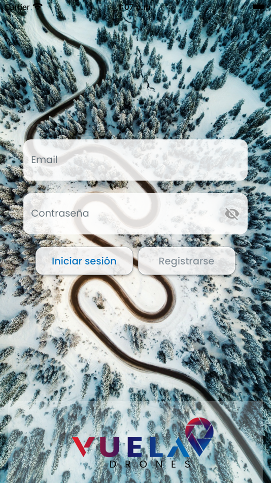
VUELA DRONES es un App que facilita la vida de los pilotos de drones y que de forma colaborativa invita a los propios pilotos a participar subiendo spots que ellos conocen, ganar puntos con esos spots que generan y poder recibir recompensas conforme van acumulando puntos. De esta forma además de ayudar y aportar a la comunidad de pilotos de drones y al sector, cualquier piloto puedes saber donde puede volar su dron y que tipo de escenario va a poder grabar cuando se desplace a dicho spot. Nos permite planificar nuestras operativas con drones, elegir el mejor spot según la época del año o la hora del día así como según el tipo de material audiovisual que nos guste grabar o fotografiar con nuestro dron.
VUELA DRONES es una APP para ayudarte y para que ayudes y aportes tu experiencia al resto de pilotos.
Vuela alto, vuela lejos, pero nunca dejes de soñar. ¡Te esperamos!
螢幕擷取畫面


價錢
- 今天: 免費
- 最小值: 免費
- 最大值: 免費
追蹤票價
開發人員
- Droneguru Servicios Aereos SL
- 平台: iOS 應用程式 (1)
- 清單: 0 + 0
- 點數: 0 + 1 ¡
- 排名: 0
- 評測: 0
- 折扣: 0
- 影片: 0
- RSS: 訂閱
點數
未找到 ☹️
排名
未找到 ☹️
清單
未找到 ☹️
評測
成為第一個評論 🌟
其他資訊
你可能還喜歡
-
- Drones-Out
- iOS 應用程式: 地圖與導航 由: Jeffrey Hatala
- 免費
- 清單: 0 + 0 排名: 0 評測: 0
- 點數: 0 + 0 版本: 1.0.6 Everyone wants to fly safely. Whether you are in a plane in flight or flying an FAA registered drone device. Drones are a big hit with amateur flyers and it is critical that your ... ⥯
-
- SkyGuard for Drones
- iOS 應用程式: 地圖與導航 由: Aerial Tech AG
- 免費
- 清單: 0 + 0 排名: 0 評測: 0
- 點數: 0 + 1 (5.0) 版本: 1.4 Skyguard for Drones makes your drone flights worry free. Whether you re a novice drone pilot or an experienced one, SkyGuard ensures your journey in the skies remains trouble-free. It ... ⥯
-
- ENAIRE Drones
- iOS 應用程式: 地圖與導航 由: ENAIRE
- 免費
- 清單: 0 + 0 排名: 0 評測: 0
- 點數: 0 + 0 版本: 2.1.3 Planifica tu vuelo: La aplicación ENAIRE Drones ofrece ayuda a los pilotos y operadores de UAS y aeronaves no tripuladas civiles, poniendo a su disposición la información sobre las ... ⥯
-
- Zing Pilot
- iOS 應用程式: 地圖與導航 由: Zing Drones
- 免費
- 清單: 0 + 0 排名: 0 評測: 0
- 點數: 0 + 2 (1.5) 版本: 9.5 Making deliveries with your DJI drone has never been easier. Just tap a spot on the map to select your custom delivery coordinates. Your drone will take off, fly to, and descend at the ⥯
-
- Radarbot: Speed Cameras | GPS
- iOS 應用程式: 地圖與導航 由: Iteration Mobile S.L
- 免費
- 清單: 0 + 0 排名: 0 評測: 0
- 點數: 3 + 95,237 (4.6) 版本: 9.29 Radarbot is the only app that offers real-time alerts and offline detection for speed cameras. Get comprehensive speed camera alerts, real-time traffic updates, and specific speed ... ⥯
-
- ANRA Mission Planner
- iOS 應用程式: 地圖與導航 由: ANRA Technologies
- 免費
- 清單: 0 + 0 排名: 0 評測: 0
- 點數: 0 + 4 (5.0) 版本: 1.3.2 ANRA Mission Planner app provides a convenient way to plan missions for drones and see the airspace information. There are two mission profiles (Line String & Polygrid) which help ... ⥯
-
- Dronetag
- iOS 應用程式: 地圖與導航 由: Dronetag
- 免費
- 清單: 0 + 0 排名: 0 評測: 0
- 點數: 0 + 6 (2.2) 版本: 2.155.11 Dronetag brings an all-in-one solution for safe drone flights that allows you to comply with the new European regulations, manage your fleet and stay informed about your current ... ⥯
-
- mapix
- iOS 應用程式: 地圖與導航 由: Mapix
- 免費
- 清單: 0 + 0 排名: 0 評測: 0
- 點數: 0 + 0 版本: 1.2.6 Wat als je de omgeving volledig in 3D kan vastleggen zonder een grote investering te moeten doen? Wat als dit digitaal model er niet enkel mooi uitziet maar ook nog enorm functioneel ... ⥯
-
- DroneSense OpsHub
- iOS 應用程式: 地圖與導航 由: DroneSense INC
- 免費
- 清單: 0 + 0 排名: 0 評測: 0
- 點數: 0 + 1 (5.0) 版本: 2025.3 Elevate Public Safety with Real-Time Video Streaming and GPS Tracking In the fast-paced world of public safety and emergency response, situational awareness is paramount. DroneSense ... ⥯
-
- Iphigénie | The Hiking Map App
- iOS 應用程式: 地圖與導航 由: Iphigenie
- * 免費
- 清單: 0 + 0 排名: 0 評測: 0
- 點數: 0 + 17 (4.5) 版本: 14.3.4 Iphigénie is the hiking map app for outdoor enthusiasts in France and around the world. Perfect for individuals (hikers, trailers, bikers, horse riders ) and professionals (guides, ... ⥯
-
- Voa na Boa
- iOS 應用程式: 地圖與導航 由: Autoridade Nacional da Aviação Civil
- 免費
- 清單: 0 + 0 排名: 0 評測: 0
- 點數: 0 + 1 (5.0) 版本: 2.0.4 Voa na Boa App é uma aplicação que permite aos utilizadores saberem em que condições podem voar com o seu Drone no território Nacional (Portugal Continental). A aplicação permite ... ⥯
-
- Drone Assist - Flight Planning
- iOS 應用程式: 地圖與導航 由: Altitude Angel Ltd
- 免費
- 清單: 0 + 0 排名: 0 評測: 0
- 點數: 0 + 19 (4.5) 版本: 2.4.167213 Plan and submit your drone flights, check the weather, fly safely, and be in control with Drone Assist, the industry s most trusted drone flight situational awareness source. Do your ... ⥯
-
- swisstopo
- iOS 應用程式: 地圖與導航 由: swisstopo
- 免費
- 清單: 0 + 0 排名: 0 評測: 0
- 點數: 0 + 17 (4.2) 版本: 1.19.2 On the road with the best app of the year: the swisstopo app won the "Master of Swiss Apps 2021" award. Use the famous national maps to discover even the most remote places in ... ⥯
-
- Iris Tactics
- iOS 應用程式: 地圖與導航 由: Unblur SL
- 免費
- 清單: 0 + 0 排名: 0 評測: 0
- 點數: 0 + 0 版本: 3.3.1 IRIS Tactics is a smartphone application for commanders in the field, designed to operate with IRIS Core. Unblur is a company providing SaaS solutions for fast, safe, and simple ... ⥯