| Desarrollador: | Hilton Software LLC (2) | ||
| Precio: | Gratis | ||
| Clasificaciones: | 0 | ||
| Opiniones: | 0 Escribir una opinión | ||
| Listas: | 0 + 0 | ||
| Puntos: | 0 + 163 ¡ | ||
| Puntos + 1 | |||
Descripción
")
● VFR Free!, CFI Free!, and MilitaryFree! - only VFR flying, CFI, or Active or Retired Military? Subscription is free.
● $74.95 annual subscription (or $199.95 for 3 years)
● $74.95 for Advanced IFR Subscription
● Free: 30-day Free Period
● Free: Synthetic Vision and Fuel Prices (with current subscription)
Annual Subscription
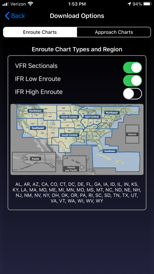
Includes VFR Sectionals, IFR Enroute Low and High, TACs, Flyway, Helicopter, Grand Canyon, and IFR Area charts plus APDs (geo-referenced), IAPs, etc
Advanced IFR Subscription
IAP geo-referencing, IAP Routing and ChartTouch
New!
Features:
● Display Instrument Approach Procedures on the Moving Map.
● Minimum Vectoring Altitude Overlays on the Moving Map.
● New Advanced Moving Map with significant performance and stability improvements
● Visual region-based moving map data download selection. Faster downloads by downloading only what you need.
● Improved weather display - better animation, faster downloading, and vastly less network bandwidth usage
● Reworked data dissemination process to enable earlier release of cycle data, improved dual-cycle data management, dynamic real-time system configuration.
● Winner of many awards including multiple Stevie Awards, Appy Awards, and Aviation Consumer.
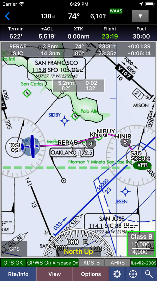
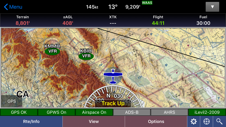
GPS-Enabled Moving Map
● VFR Sectionals, IFR Enroute Low and High, TACs, Flyways, Helicopter, Grand Canyon, and IFR Area charts
● Wx Overlays including NEXRAD composite and many other weather overlay types with animation, transparency, and low-bandwidth option (e.g. hotel rooms)
● DP, STAR, and IAP Routing (iPad only)
● North Up or Track Up
● Split Screen
● Business locations on Airport Diagrams
● ADS-B In-Flight Weather and Traffic
● X-Plane and MS Flight Sim compatible
● Ground Proximity Warning System (GPWS) - terrain and obstacles
● SmartTaxi™ - advanced taxi warning system
● FlightShare™ - share routes on the ground or in the air!
● traca™ Technology - simply draw the route
● WingX Rewind™ - record and playback flights including GPS, AHRS, and Pitot-Static.
● Auto switch to Airport Diagram
● Class B Transitions
● Search And Rescue Grids and Patterns (old/new) - Parallel, Square, Sector, and Auto Fill Grid - supports MGRS
● Overlay terrain and obstacles (terrain up to 60N)
● State Lines
● Airspace overlays
● Airspace Notifications
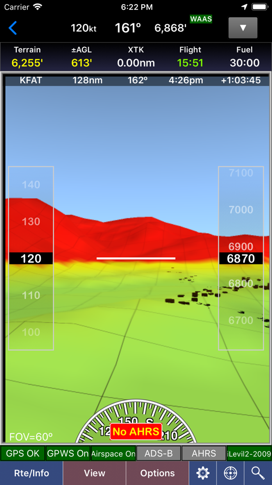
● Passive RADAR Altimeter - Terrain Elevation or AGL
● Terrain Profile View - with climb angle and 500fpm descent lines
● AHRS-driven Attitude Indicator
● Built-in Simulator
● Extra dimming for night operations
● Rubber-Banding
● User-Defined Waypoints
● Multi-Page Notepad with Undo
● Runway Extensions and Traffic Patterns
● Easy GPS Calibration - tap on moving map's altitude
● Count-Up/Down timers
● Numerous aircraft icons
● Stadium TFRs
Approach Charts
● Print charts wirelessly
● Rotate DPs and STARs
● Draw on approach charts
Wx Text
● Color-coded and decoded METARs, TAFs, winds/temps aloft
● METAR Density Altitude and Freezing Levels
Route Planning
● Victor Airways, Jetways, DPs, STARs, and even IAPs!
● Total and Longer Than Direct distances
● Flight Log shows Headings, GS, ETE, Fuel Burn using winds aloft
● Optimize Altitude for winds aloft
Flight Service
● Flight Plans and Weather Briefings with Leidos. Can be reused for fast filing
● File, Close, and Cancel flight plans
● Route and Area Weather Briefings
● Aircraft Manager for auto-fill
E6B
● TAS
● Conversions
● Distance-Speed-Time
● Pressure/Density Altitude
● Winds Aloft
● Runway Winds
● IFR Climb
● Descent Rate
Documents
● ACS and PTS
● Parts of the AIM
● AC61-65H - Including Endorsements
● AC61-67C - Stall and Spin Awarenes
● Pilot/Controller Glossary
● Aeronautical Contractions
● User-Documents
Integrated Help System
● Built-in mini-manual
Note: Continued use of GPS running in the background can dramatically decrease battery life.
Follow Us!
Twitter: @hiltonsoftware
Facebook: @hiltonsoftware
Instagram: @hilton.software
Capturas...
Novedades
- Versión: 9.2.3
- Actualizado:
- Improved app stability and performance.
Precio
- Hoy: Gratis
- Mínimo: Gratis
- Máximo: Gratis
Realizar un seguimiento de los precios
Desarrollador
- Hilton Software LLC
- Plataformas: Android Aplicaciones (1) iOS Aplicaciones (1)
- Listas: 0 + 0
- Puntos: 0 + 260 ¡
- Clasificaciones: 0
- Opiniones: 0
- Descuentos: 0
- Vídeos: 0
- RSS: Suscribirse
Puntos
No encontrada ☹️
Clasificaciones
No encontrada ☹️
Listas
No encontrada ☹️
Opiniones
Sé el primero en escribir una reseña!
Información adicional
- Categoría:
iOS Aplicaciones›Navegación - Sistemas operativos:
iPad,iPhone,iOS 12.0 y versiones posteriores - Tamaño:
64 Mb - Idiomas admitidos:
English - Clasificación de contenido:
4+ - App Store Puntuación:
3.6(163) - Actualizado:
- Fecha de lanzamiento:
Contactos
- Facebook: hiltonsoftware
También te puede interesar
-
- Ecliptic Compass
- iOS Aplicaciones: Navegación De: wing lun tong
- $1.99
- Listas: 0 + 0 Clasificaciones: 0 Opiniones: 0
- Puntos: 0 + 2 Versión: 1.1 Features: *Normal Compass(check the location shown in the bottom first. You can use the button in the bottom left to retrieve your current location) *Drawing the Ecliptic Plane, the ...
-
- Calmer Parking
- iOS Aplicaciones: Navegación De: Wing-Yi Lin
- Gratis
- Listas: 0 + 0 Clasificaciones: 0 Opiniones: 0
- Puntos: 0 + 0 Versión: 1.4 Unlock the potential of your parking space for extra income! Ready to turn your parking into profit? Start now!
-
- RocketRoute Marketplace
- iOS Aplicaciones: Navegación De: RocketRoute Ltd.
- Gratis
- Listas: 0 + 0 Clasificaciones: 0 Opiniones: 0
- Puntos: 0 + 1 Versión: 4.1 Free to use and with no commission charges. Now with 40,000+ airports, 35,000+ vendors locations added. If you fly privately or for an operation, use Marketplace to order services ...
-
- Monuments Of Agra
- iOS Aplicaciones: Navegación De: Kuljeet Kumar
- Gratis
- Listas: 0 + 0 Clasificaciones: 0 Opiniones: 0
- Puntos: 0 + 0 Versión: 1.0 The Archaeological Survey of India (ASI), under the Ministry of Culture, is the premier organization for the archaeological researches and protection of the cultural heritage of the ...
También te puede interesar
- iOS Aplicaciones
- Nuevas iOS Aplicaciones
- Navegación iOS Aplicaciones : Nuevas
- Vídeos iOS Aplicaciones
- Populares iOS Aplicaciones
- Navegación iOS Aplicaciones : Populares
- Descuentos iOS Aplicaciones
- Navegación iOS Aplicaciones : Descuentos
- Clasificaciones iOS Aplicaciones
- Opiniones iOS Aplicaciones
- Listas iOS Aplicaciones
- Puntos iOS Aplicaciones