| 開發人員: | Hilton Software LLC (2) | ||
| 價錢: | 免費 | ||
| 排名: | 0 | ||
| 評測: | 0 寫評論 | ||
| 清單: | 0 + 0 | ||
| 點數: | 1 + 180 (3.6) ¡ | ||
| App Store | |||
描述
")
● VFR Free! and MilitaryFree! - only VFR flying or Active or Retired Military? Subscription is free.
● $74.95 annual subscription (or $199.95 for 3 years)
● $74.95 for Advanced IFR Subscription
● Free: 30-day Free Period
● Free: Synthetic Vision and Fuel Prices (with current subscription)
Annual Subscription
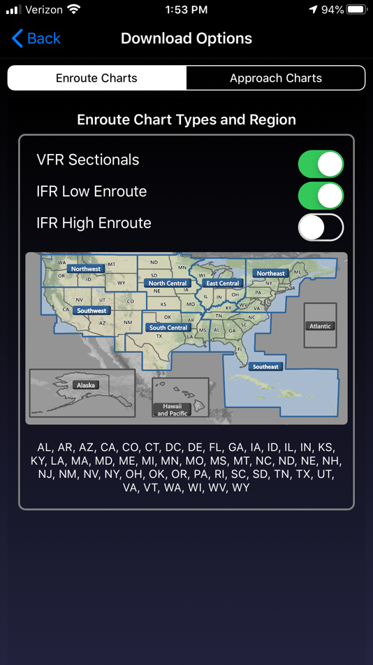
Includes VFR Sectionals, IFR Enroute Low and High, TACs, Flyway, Helicopter, Grand Canyon, and IFR Area charts plus APDs (geo-referenced), IAPs, etc
Advanced IFR Subscription
IAP geo-referencing, IAP Routing and ChartTouch
New!
Features:
● Display Instrument Approach Procedures on the Moving Map.
● Minimum Vectoring Altitude Overlays on the Moving Map.
● New Advanced Moving Map with significant performance and stability improvements
● Visual region-based moving map data download selection. Faster downloads by downloading only what you need.
● Improved weather display - better animation, faster downloading, and vastly less network bandwidth usage
● Reworked data dissemination process to enable earlier release of cycle data, improved dual-cycle data management, dynamic real-time system configuration.
● Winner of many awards including multiple Stevie Awards, Appy Awards, and Aviation Consumer.
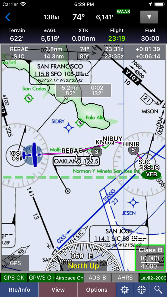
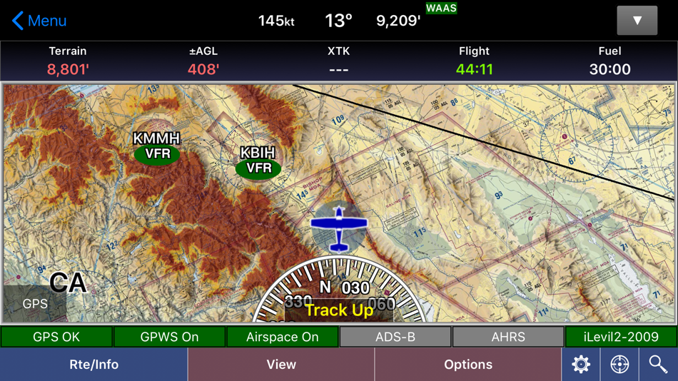
GPS-Enabled Moving Map
● VFR Sectionals, IFR Enroute Low and High, TACs, Flyways, Helicopter, Grand Canyon, and IFR Area charts
● Wx Overlays including NEXRAD composite and many other weather overlay types with animation, transparency, and low-bandwidth option (e.g. hotel rooms)
● DP, STAR, and IAP Routing (iPad only)
● North Up or Track Up
● Split Screen
● Business locations on Airport Diagrams
● ADS-B In-Flight Weather and Traffic
● X-Plane and MS Flight Sim compatible
● Ground Proximity Warning System (GPWS) - terrain and obstacles
● SmartTaxi™ - advanced taxi warning system
● FlightShare™ - share routes on the ground or in the air!
● traca™ Technology - simply draw the route
● WingX Rewind™ - record and playback flights including GPS, AHRS, and Pitot-Static.
● Auto switch to Airport Diagram
● Class B Transitions
● Search And Rescue Grids and Patterns (old/new) - Parallel, Square, Sector, and Auto Fill Grid - supports MGRS
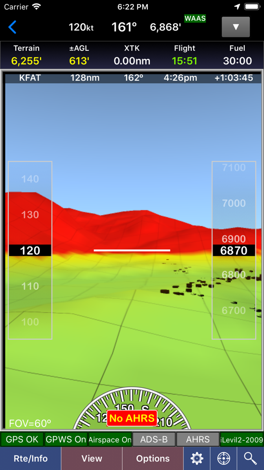
● Overlay terrain and obstacles (terrain up to 60N)
● State Lines
● Airspace overlays
● Airspace Notifications
● Passive RADAR Altimeter - Terrain Elevation or AGL
● Terrain Profile View - with climb angle and 500fpm descent lines
● AHRS-driven Attitude Indicator
● Built-in Simulator
● Extra dimming for night operations
● Rubber-Banding
● User-Defined Waypoints
● Multi-Page Notepad with Undo
● Runway Extensions and Traffic Patterns
● Easy GPS Calibration - tap on moving map's altitude
● Count-Up/Down timers
● Numerous aircraft icons
● Stadium TFRs
Approach Charts
● Print charts wirelessly
● Rotate DPs and STARs
● Draw on approach charts
Wx Text
● Color-coded and decoded METARs, TAFs, winds/temps aloft
● METAR Density Altitude and Freezing Levels
Route Planning
● Victor Airways, Jetways, DPs, STARs, and even IAPs!
● Total and Longer Than Direct distances
● Flight Log shows Headings, GS, ETE, Fuel Burn using winds aloft
● Optimize Altitude for winds aloft
Flight Service
● Flight Plans and Weather Briefings with Leidos. Can be reused for fast filing
● File, Close, and Cancel flight plans
● Route and Area Weather Briefings
● Aircraft Manager for auto-fill
E6B
● TAS
● Conversions
● Distance-Speed-Time
● Pressure/Density Altitude
● Winds Aloft
● Runway Winds
● IFR Climb
● Descent Rate
Documents
● ACS and PTS
● Parts of the AIM
● AC61-65H - Including Endorsements
● AC61-67C - Stall and Spin Awarenes
● Pilot/Controller Glossary
● Aeronautical Contractions
● User-Documents
Integrated Help System
● Built-in mini-manual
Note: Continued use of GPS running in the background can dramatically decrease battery life.
Follow Us!
Twitter: @hiltonsoftware
Facebook: @hiltonsoftware
Instagram: @hilton.software
螢幕擷取畫面
新功能
- 版本: 9.2.6.206
- 發佈日期:
- Various bug fixes and performance improvements.
Adds the ability to restore In-App purchases.
價錢
- 今天: 免費
- 最小值: 免費
- 最大值: 免費
追蹤票價
開發人員
- Hilton Software LLC
- 平台: Android 應用程式 (1) iOS 應用程式 (1)
- 清單: 0 + 0
- 點數: 1 + 282 ¡
- 排名: 0
- 評測: 0
- 折扣: 0
- 影片: 0
- RSS: 訂閱
點數
-

- 3,618 Jojo Gillera
- +1

排名
0 ☹️
清單
0 ☹️
評測
成為第一個評論 🌟
其他資訊
聯絡人
- Facebook: hiltonsoftware
- 🌟 分享
- App Store
你可能還喜歡
-
- Wing - Drone delivery
- iOS 應用程式: 購物 由: Wing Aviation LLC
- 免費
- 清單: 0 + 0 排名: 0 評測: 0
- 點數: 0 + 3,255 (4.7) 版本: 1.20251104.1 Get better delivery from our partners. Wing s drone delivery service is safe, fast, and environmentally friendly. Download the app today to experience Wing drone delivery in minutes. ... ⥯
-
- Wing Fung Financial Group
- iOS 應用程式: 財經 由: Wing Fung Financial Group Limited
- 免費
- 清單: 0 + 0 排名: 0 評測: 0
- 點數: 0 + 0 版本: 1.8.4 Wing Fung Financial Group smartphone app, a collection of bullion, securities & future trading platforms in one, and also, gathered information for the group s services. Let your ... ⥯
-
- Wing e-KYC
- iOS 應用程式: 生產應用 由: WING (CAMBODIA) LIMITED SPECIALISED BANK
- 免費
- 清單: 0 + 0 排名: 0 評測: 0
- 點數: 0 + 6 (5.0) 版本: 2.5.2 Wing e-KYC is designed for eveyone to acquire new customers. This app provides the following features: - Merchant Onboarding Process - Wing account acquisition (card & cardless) - KYC ... ⥯
-
- Wing Tel
- iOS 應用程式: 公用程式與工具 由: Wing Tel Inc
- 免費
- 清單: 0 + 0 排名: 0 評測: 0
- 點數: 0 + 258 (3.5) 版本: 25.44.2 The Wing app simplifies the mobile experience, allowing you to manage your account from anywhere with the touch of a button. We re here to make life easier. Features Include: ... ⥯
-
- Wing Digital
- iOS 應用程式: 商業 由: WING INTER LOGISTICS TECHNOLOGIES CO., LTD.
- 免費
- 清單: 0 + 0 排名: 0 評測: 0
- 點數: 0 + 1 (5.0) 版本: 3.12.2.148 The Wing Digital Platform is a cutting-edge cloud-based application designed to provide exceptional functionality. Its unique blend of flexible approval workflows, precise permission ... ⥯
-
- Wing Snob
- iOS 應用程式: 美食佳飲 由: Wing Snob Franchising LLC
- 免費
- 清單: 0 + 0 排名: 0 評測: 0
- 點數: 0 + 32 (3.5) 版本: 1.5 With our app you can: * Browse through the menu & order * Receive updates and promotions * Receive exclusive discounts and coupons * Re-order your favorite items ⥯
-
- Wing Park Liquor
- iOS 應用程式: 美食佳飲 由: WING PARK LIQUORS INC
- 免費
- 清單: 0 + 0 排名: 0 評測: 0
- 點數: 0 + 0 版本: 11.28.0 Our store is the next wave in a truly unique adult beverage purchasing experience. Our highly trained, professional staff is always on hand, and ready to answer any questions you may ... ⥯
-
- Wing On Rewards
- iOS 應用程式: 購物 由: THE WING ON DEPARTMENT STORES (HONG KONG) LIMITED
- 免費
- 清單: 0 + 0 排名: 0 評測: 0
- 點數: 0 + 0 版本: 2.1.2 Wing On Rewards app has been updated, download now and enjoy the fabulous offers. Through the app, you may: Register to become Wing On Rewards member and redeem ePoint for every ... ⥯
-
- Wing - Find Your Wingman
- iOS 應用程式: 社交 由: Rajesh Nair
- 免費
- 清單: 0 + 0 排名: 0 評測: 0
- 點數: 0 + 1 (5.0) 版本: 2.9 Wing - Find Your Ultimate Social Wingman! Tailored for young, single men in the DMV area, Wing revolutionizes how you meet new people. Fed up with traditional dating apps? Wing offers ... ⥯
-
- Wing Mobility
- iOS 應用程式: 生活品味 由: Ahmed Abdeljalil
- 免費
- 清單: 0 + 0 排名: 0 評測: 0
- 點數: 0 + 2 (4.5) 版本: 65.6 Wing Mobility - Fly With Wing Wing is an electric scooter application that offers an unforgettable driving experience in Saudi Arabia, hence our slogan Fly with Wing. Wing electric ... ⥯
-
- Wing Assistant
- iOS 應用程式: 生產應用 由: Martin Gomez
- 免費
- 清單: 0 + 0 排名: 0 評測: 0
- 點數: 0 + 8 (4.4) 版本: 8.3.8 Meet Wing, an unlimited assistant for business - Do things that matter, Delegate the rest to Wing. You get a dedicated team of assistants to work on as much as you'd like, much like ... ⥯
-
- Wing me app
- iOS 應用程式: 社交 由: Alexandra Isabella Kraft
- 免費
- 清單: 0 + 0 排名: 0 評測: 0
- 點數: 0 + 2 (5.0) 版本: 2.0.3 Have you met my friend Alex? We might just be your ultimate connection companion in town. With the Wing Me app, forget endless swiping or prolonged messaging. We simplify making ... ⥯
-
- Wing Chun Techniques
- iOS 應用程式: 運動 由: ANTHONY PETER WALSH
- $2.99
- 清單: 0 + 0 排名: 0 評測: 0
- 點數: 0 + 7 (2.7) 版本: 1.0 Wing Chun really came to the limelight with Bruce Lee coming to the big screen. Wing Chub is a fantastic martial art practised and enjoyed all over the world. This app has 427 ... ⥯
-
- Wing It On Wheels
- iOS 應用程式: 美食佳飲 由: Manuel Duarte
- 免費
- 清單: 0 + 0 排名: 0 評測: 0
- 點數: 0 + 1 (5.0) 版本: 4.0 Wing It On Wheels Hot Wings, Hotter App! Attention all wing lovers! The Wing It On Wheels app is here to spice up your life with the best hot wings on wheels! From crispy, saucy ... ⥯