| Desarrollador: | NASA (57) | ||
| Precio: | Gratis | ||
| Clasificaciones: | 0 | ||
| Opiniones: | 0 Escribir una opinión | ||
| Listas: | 0 + 0 | ||
| Puntos: | 0 + 6 (3.3) ¡ | ||
| App Store | |||
Descripción
")
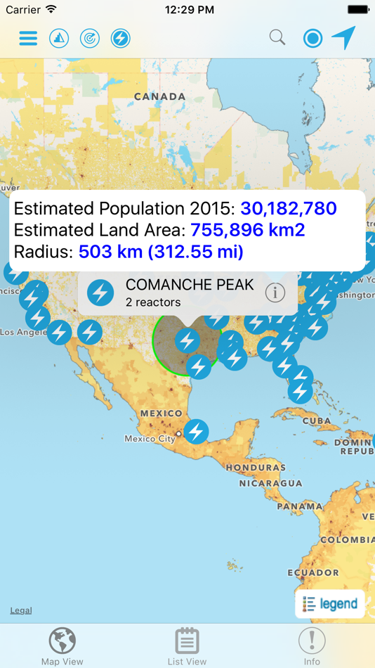
Developed by the NASA Socioeconomic Data and Applications Center (SEDAC) operated by the Center for International Earth Science Information Network (CIESIN) at Columbia University, HazPop combines data and map layers from various sources including NASA's Land, Atmosphere Near real-time Capability for EOS (LANCE) and Global Imagery Browse Services (GIBS), the U.S. Geological Survey (USGS), and others using a variety of open Web mapping services. The custom population estimates are provided by the SEDAC Population Estimation Service (PES) based on SEDAC′s Gridded Population of the World, version 4 (GPWv4) data for 2015.
HazPop is designed to be used by disaster risk managers, humanitarian response organizations, public health professionals, journalists, and others needing a quick assessment of the potential dangers posed by a major hazardous event or developing emergency. For example, a disaster response agency can obtain a rough estimate of the population and major facilities near a recent earthquake as an input into response planning. Journalists or students can explore the location of recent wildfires relative to dense populations, roads, terrain, and water bodies. Due to the coarse resolution and varying quality of some of the data, HazPop is not intended to support in-depth risk assessment or location-specific response needs.
HazPop supports a number of other functions including: Monitoring regions around an area of interest, e.g. hazardous area prone to natural disasters, major infrastructure, or densely populated areas; Sorting dams, nuclear power plants, or earthquakes by proximity to your location or by their characteristics; Determining the distance from your location to any point on the map or between any two points on the map.
Capturas...


Novedades
- Versión: 2.0
- Actualizado:
- * The population estimation is now based on the new version 3.0 of the SEDAC Population Estimation Service (PES v3), which uses the latest version 4.11 of the SEDAC Population Count data set from the Gridded Population of the World (GPW) data collection.
* Added ability to display chart showing estimated population trend changes in 5-year intervals from 2000 to 2020.
* New imagery layer from NASA GIBS for display of global fires in the last 48 hours.
Precio
- Hoy: Gratis
- Mínimo: Gratis
- Máximo: Gratis
Realizar un seguimiento de los precios
Desarrollador
- NASA
- Plataformas: Android Aplicaciones (11) Android Juegos (3) iOS Aplicaciones (36) iOS Juegos (3) macOS Juegos (1) Steam Juegos (1) Xbox Juegos (2)
- Listas: 5 + 0
- Puntos: 10 + 197,959 ¡
- Clasificaciones: 5 (1)
- Opiniones: 0
- Descuentos: 0
- Vídeos: 2
- RSS: Suscribirse
Puntos
0 ☹️
Clasificaciones
0 ☹️
Listas
0 ☹️
Opiniones
Sé el primero en escribir una reseña 🌟
Información adicional
- Versión: 2.0
- Categoría:
iOS Aplicaciones›Referencia - Sistemas operativos:
iPad,iPhone,iOS 9.0 y versiones posteriores - Tamaño:
12 Mb - Idiomas admitidos:
English - Clasificación de contenido:
4+ - App Store Puntuación:
3.3(6) - Actualizado:
- Fecha de lanzamiento:
- 🌟 Compartir
- App Store
También te puede interesar
-
- SnoTel Mapper
- iOS Aplicaciones: Referencia De: Jason Flaherty
- * $2.49
- Listas: 0 + 0 Clasificaciones: 0 Opiniones: 0
- Puntos: 0 + 0 Versión: 4.0.0 SnoTel Mapper puts real-time snow data from 900+ SNOTEL weather stations in your pocket. Perfect for backcountry skiers, snowboarders, and anyone who needs accurate snowpack ... ⥯
-
- PCGS CoinFacts Coin Collecting
- iOS Aplicaciones: Referencia De: PCGS
- Gratis
- Listas: 0 + 0 Clasificaciones: 0 Opiniones: 0
- Puntos: 0 + 59,303 (4.8) Versión: 3.2.5 Coin collectors finally have the resource needed to make informed numismatic buying, selling and trading decisions, thanks to the PCGS CoinFacts mobile app. The world s largest ... ⥯
-
- HazMat Reference
- iOS Aplicaciones: Referencia De: ThatsMyStapler Inc.
- $4.99
- Listas: 0 + 0 Clasificaciones: 0 Opiniones: 0
- Puntos: 1 + 1,622 (4.8) Versión: 3.5 Your best quick reference for hazardous materials. Includes: NIOSH, CFR/HMT, NFPA, GHS, CAMEO information. This app serves as a quick reference and educational tool for employees that ... ⥯
-
- 世界地图典藏版 - 含全球排行和中国地理知识
- iOS Aplicaciones: Referencia De: 阳 沈
- Gratis
- Listas: 0 + 1 Clasificaciones: 0 Opiniones: 0
- Puntos: 1 + 20 (5.0) Versión: 3.1.0 Features: Abundant and complete world knowledge treasure Maps of all countries in the world and provinces in China it supports offline use and can watch the world without Internet ... ⥯
-
- Zip Codes
- iOS Aplicaciones: Referencia De: VersaEdge Software, LLC
- Gratis
- Listas: 0 + 0 Clasificaciones: 0 Opiniones: 0
- Puntos: 1 + 2,491 (4.8) Versión: 4.0.6 Contains zip code information for all Zip Codes covering cities across the US and US territories. Quickly lookup a zip code Displays state, cities, zip code population and county ... ⥯
-
- CAMEO Chemicals
- iOS Aplicaciones: Referencia De: National Oceanic and Atmospheric Administration
- Gratis
- Listas: 0 + 0 Clasificaciones: 0 Opiniones: 0
- Puntos: 0 + 25 (4.2) Versión: 3.1.0 CAMEO Chemicals is a database of hazardous chemical datasheets that emergency responders and planners can use to get response recommendations and predict hazards (such as explosions or ⥯
-
- Countries & World
- iOS Aplicaciones: Referencia De: Azamjon Anvarov
- Gratis
- Listas: 0 + 0 Clasificaciones: 0 Opiniones: 0
- Puntos: 0 + 0 Versión: 3 Countries is your all-in-one destination for exploring detailed and accurate information about every country in the world. Powered by two powerful APIs - REST Countries and API ... ⥯
-
- NGC
- iOS Aplicaciones: Referencia De: Numismatic Guaranty Corporation
- Gratis
- Listas: 0 + 0 Clasificaciones: 0 Opiniones: 0
- Puntos: 0 + 23 (1.9) Versión: 1.8.4 The free NGC App gives coin collectors access to many of the most popular resources developed by NGC, a leading third-party coin grading service. This app now includes: Verify NGC ... ⥯
-
- GIN Switzerland
- iOS Aplicaciones: Referencia De: Federal Office for the Environment FOEN
- Gratis
- Listas: 0 + 0 Clasificaciones: 0 Opiniones: 0
- Puntos: 0 + 0 Versión: 1.3.7 The federal agencies that deal with natural hazards use the Common Information Platform for Natural Hazards (GIN) to share information on natural hazards with other experts at federal, ⥯
-
- The World Flags *
- iOS Aplicaciones: Referencia De: Ratha Sou
- Gratis
- Listas: 0 + 0 Clasificaciones: 0 Opiniones: 0
- Puntos: 0 + 539 (4.7) Versión: 1.7.5 Do you know the definition of the flag of your country? This app will tell you more than just the definition of the flag of your country and more information about your country. ... ⥯
-
- Bird Identifier, Bird Id
- iOS Aplicaciones: Referencia De: FAMO Connect LLC
- Gratis
- Listas: 0 + 0 Clasificaciones: 0 Opiniones: 0
- Puntos: 0 + 1,747 (4.5) Versión: 74.0.0 Looking for a quick and accurate way to identify the birds around you? Our AI-powered bird identifier app makes it simple to recognize and learn about birds from a single photo. ... ⥯
-
- Facts - Daily Random Facts
- iOS Aplicaciones: Referencia De: TRENDING MOBAPPS SRL
- Gratis
- Listas: 1 + 0 Clasificaciones: 0 Opiniones: 0
- Puntos: 1 + 90 (4.0) Versión: 8.0 Did you know that Almost 15 percent of Earth's Population Is Missing a Tendon? Learn something new everyday with Daily Facts! Explore thousands of facts and interesting content, ... ⥯
-
- IP Tools - Network Debug Tool
- iOS Aplicaciones: Referencia De: AppziBrain Infotech LLP
- * Gratis
- Listas: 0 + 0 Clasificaciones: 0 Opiniones: 0
- Puntos: 0 + 0 Versión: 1.0 This application is a simple network ping tool. It makes possible to pinging a device in the local network, or pinging an external device by ip or by domain. 'IPv4 info' - a fast way ... ⥯
-
- Atlas Pro: Maps & Facts
- iOS Aplicaciones: Referencia De: Appventions
- $2.99
- Listas: 0 + 0 Clasificaciones: 0 Opiniones: 0
- Puntos: 0 + 288 (4.5) Versión: 4.1 Your Ultimate Guide to the World Right on Your iPad! Dive into the wonders of our planet with Atlas Pro: Maps & Facts, the interactive world atlas packed with beautifully detailed ... ⥯