| Nhà phát triển: | Navisys Technology Corp. (9) | ||
| Giá bán: | Miễn phí | ||
| Xếp hạng: | 0 | ||
| Đánh giá: | 0 Viết đánh giá | ||
| Danh sách: | 0 + 0 | ||
| Điểm: | 0 + 0 ¡ | ||
| App Store | |||
Mô tả
")
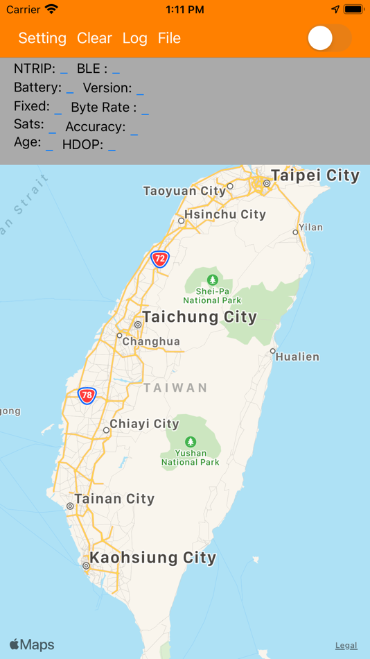
2. App receive correction data from reference station and forward to receiver.
3. Receiver calculate the data and decide it's precision position, then send GGA to App
4.Finally App draw the position in map.
App is a utility tool for testing the receiver.
a.Relative position measurement
GR-9029 have a button in it.
User press the button ,then App will draw a pin in map.
When user press again , the App draw a new pin and show the distance between two pin (If "distance measurement" function is enable)
b. Absolute position measurement.
Receiver is placed on a known position. User can compare the known position with the coordinate show in map.
c.Benchmark with other receiver
App support "Log" function , it can record entire path .
User can compare the path with others and check the deviation
Ảnh chụp màn hình
Tính năng mới
- Phiên bản: 2.6
- Cập nhật:
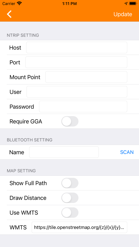
- 1. add ARP/PCO Setting
2.Measurement improve(Geodesic/Ground distance)
Giá bán
- Hôm nay: Miễn phí
- Tối thiểu: Miễn phí
- Tối đa: Miễn phí
Theo dõi giá
Nhà phát triển
- Navisys Technology Corp.
- Nền tảng: Android Ứng dụng (5) iOS Ứng dụng (4)
- Danh sách: 0 + 0
- Điểm: 0 + 0 ¡
- Xếp hạng: 0
- Đánh giá: 0
- Giảm giá: 0
- Video: 0
- RSS: Đăng ký
Điểm
0 ☹️
Xếp hạng
0 ☹️
Danh sách
0 ☹️
Đánh giá
Hãy là người đầu tiên đánh giá 🌟
Thông tin bổ sung
- Phiên bản: 2.6
- Danh mục:
iOS Ứng dụng›Tiện ích - HĐH:
iPad,iPhone,iOS 12.4 trở lên - Kích thước:
13 Mb - Ngôn ngữ được hỗ trợ:
English - Xếp hạng nội dung:
4+ - App Store Xêp hạng:
0 - Cập nhật:
- Ngày phát hành:
Danh bạ
- Trang web:
 http://www.navisys.com.tw
- 🌟 Chia sẻ
- App Store
Bạn cũng có thể thích
-
- PIX4Dcatch: 3D scanner
- iOS Ứng dụng: Tiện ích Bởi: Pix4D
- * Miễn phí
- Danh sách: 0 + 0 Xếp hạng: 0 Đánh giá: 0
- Điểm: 4 + 255 (4.7) Phiên bản: 2.18.0 DIGITIZE REALITY Transform your mobile device into a powerful 3D scanner. Simply point and capture images and LiDAR data to create accurate 3D models ready for professional use. Pair ... ⥯
-
- OnPOZ Collect
- iOS Ứng dụng: Tiện ích Bởi: CPAT Flex Inc.
- * Miễn phí
- Danh sách: 0 + 0 Xếp hạng: 0 Đánh giá: 0
- Điểm: 0 + 0 Phiên bản: 1.37 Discover an easy to use, powerful GIS data collection application. Use your iPhone or iPad to collect geospatial data, locate and inspect features on the field. You can easily ... ⥯
-
- viDoc
- iOS Ứng dụng: Tiện ích Bởi: Vigram GmbH
- * Miễn phí
- Danh sách: 0 + 0 Xếp hạng: 0 Đánh giá: 0
- Điểm: 0 + 0 Phiên bản: 2.5.6 The viApps becomes a real surveying and documentation device in connection with a viDoc Hardware. You can position yourself globally or locally on your construction site for daily ... ⥯
-
- EASY type-V FirePlus
- iOS Ứng dụng: Tiện ích Bởi: DILTS JAPAN, LIMITED LIABILITY CO.
- * Miễn phí
- Danh sách: 0 + 0 Xếp hạng: 0 Đánh giá: 0
- Điểm: 0 + 0 Phiên bản: 3.35 This app edit fuel mapping and spark angle adjust (EASY mode) which the Fuel Injection / Spark Angle piggyback controller DILTS JAPAN's ENIGMA FirePlus type-V. This App can control ... ⥯
-
- BLE tools with terminal
- iOS Ứng dụng: Tiện ích Bởi: Yihang Huang
- Miễn phí
- Danh sách: 0 + 0 Xếp hạng: 0 Đánh giá: 0
- Điểm: 0 + 0 Phiên bản: 1.0.7 A practical BluetoothLE scanning tool that can connect to BLE Bluetooth devices to obtain information, supports terminal mode, and can set function keys. It is a very convenient tool ... ⥯
-
- Go Fly for DJI Drones Control
- iOS Ứng dụng: Tiện ích Bởi: LEAN ASIA CO., LTD
- * Miễn phí
- Danh sách: 0 + 0 Xếp hạng: 0 Đánh giá: 0
- Điểm: 1 + 0 Phiên bản: 1.0.0 Unlock the skies with Go Fly for DJI Drone Control, Smart Remote Controller for DJI Drones the ultimate drone flying companion app designed to help every pilot fly smarter, safer, and ... ⥯
-
- GPS Fields areas measure
- iOS Ứng dụng: Tiện ích Bởi: Mykola Kondratiuk
- * Miễn phí
- Danh sách: 0 + 0 Xếp hạng: 0 Đánh giá: 0
- Điểm: 1 + 0 Phiên bản: 1.2 The easiest way to measure the land area. Enter the application, turn on the track recording and go around the perimeter of the land, then save the track in kml file for export of the ... ⥯
-
- Geode Connect
- iOS Ứng dụng: Tiện ích Bởi: Juniper Systems Inc.
- Miễn phí
- Danh sách: 0 + 0 Xếp hạng: 0 Đánh giá: 0
- Điểm: 0 + 9 (3.8) Phiên bản: 2.5.2 GEODE CONNECT is a configuration and communication utility for the GEODE GNSS RECEIVER. It provides the ability to establish communications to the Geode Real-Time Sub-meter GPS/GNSS ... ⥯
-
- Bad Elf Flex
- iOS Ứng dụng: Tiện ích Bởi: Bad Elf, LLC.
- Miễn phí
- Danh sách: 0 + 0 Xếp hạng: 0 Đánh giá: 0
- Điểm: 0 + 11 (3.5) Phiên bản: 1.4.2 This is the free companion utility app for the flexible, intuitive, and affordable Bad Elf Flex and Flex Mini GNSS receivers. Designed for GIS and survey professionals, the Bad Elf ... ⥯
-
- Emlid Flow
- iOS Ứng dụng: Tiện ích Bởi: Emlid Tech Kft.
- * Miễn phí
- Danh sách: 0 + 0 Xếp hạng: 0 Đánh giá: 0
- Điểm: 0 + 26 (3.9) Phiên bản: 13.18 Emlid Flow is a companion app for Emlid Reach receivers, designed to manage devices and handle all your positioning tasks in one place. The app has Free and Survey plans for a wide ... ⥯
-
- OnesightAR·ConstructionAsst.
- iOS Ứng dụng: Tiện ích Bởi: 以见科技(上海)有限公司
- Miễn phí
- Danh sách: 0 + 0 Xếp hạng: 0 Đánh giá: 0
- Điểm: 0 + 0 Phiên bản: 5.2.0 Construction Assistant is a BIM construction management tool based on AR and 3D visualization. We use AR visualization to truly restore your design intent, enhance the implementation ... ⥯
-
- ScanAce
- iOS Ứng dụng: Tiện ích Bởi: ITS Geo Solutions GmbH
- * Miễn phí
- Danh sách: 0 + 0 Xếp hạng: 0 Đánh giá: 0
- Điểm: 0 + 0 Phiên bản: 25.3 ScanAce is a professional 3D scanning app for surveyors, construction and utility workers, archeologists, architects, and GIS professionals. It turns your smartphone or tablet into a ... ⥯
-
- NEXMOW
- iOS Ứng dụng: Tiện ích Bởi: URSrobot AI Inc.
- Miễn phí
- Danh sách: 0 + 0 Xếp hạng: 0 Đánh giá: 0
- Điểm: 0 + 1 (5.0) Phiên bản: 1.15.2 Unlock business growth with NEXMOW! URSROBOT's cutting-edge robotic mower. Say goodbye to laborious mowing tasks and hello to enhanced efficiency. Whether solo or in a fleet, NEXMOW ... ⥯
-
- Photogram.pro
- iOS Ứng dụng: Tiện ích Bởi: Photogram Srl
- Miễn phí
- Danh sách: 0 + 0 Xếp hạng: 0 Đánh giá: 0
- Điểm: 0 + 0 Phiên bản: 1.2.6 The Photogram platform allows you to manage all your survey projects. Our handheld GNSS/RTK receiver is fully integrated into the app and connects via Bluetooth Low Energy. Your ... ⥯