| 開發人員: | Kuldeep Ghoghari (6) | ||
| 價錢: | * 免費 | ||
| 排名: | 0 | ||
| 評測: | 0 寫評論 | ||
| 清單: | 0 + 0 | ||
| 點數: | 0 + 0 ¡ | ||
| App Store | |||
描述
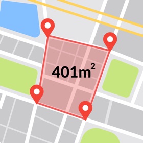
GPS Field Area Measure Map is a powerful, easy-to-use GPS measurement tool designed to help users calculate area, distance, and accurately mark locations on the map—perfect for professionals and enthusiasts across agriculture, landscaping, construction, real estate, and outdoor activities. Whether you’re measuring a large farm, mapping out a construction site, or simply tracking your hiking route, this app provides a comprehensive set of tools in a sleek and user-friendly interface.
With GPS Field Area Measure Map, you can instantly calculate the size of any land parcel or surface by placing points on the map or by walking/driving around the perimeter. The built-in GPS and satellite view provide precise geolocation capabilities to ensure highly accurate measurements, making your mapping tasks simpler and more reliable.
Key Features:
Distance Measure:
Measure the distance between any two or more points on the map. Ideal for planning routes, measuring travel paths, or checking property lengths.
Area Size Calculator:
Easily calculate the total area of any polygon you draw on the map. Whether it's a garden, a field, or an entire estate, just tap around the borders to instantly get size estimates.
Mark Location:
Pinpoint and save important locations with custom markers. Perfect for noting landmarks, property boundaries, water sources, or waypoints during travel.
Various map modes:
standard, terrain, hybrid, and satellite. Each view provides unique insights to suit your needs — from land structure to elevation.
Satellite Compass:
Leverage satellite imagery combined with a digital compass to better understand orientation and direction in any location. Ideal for aligning property lines or navigating unfamiliar terrain.
Camera Compass:
Use your device’s camera in augmented reality mode with an integrated compass overlay to enhance on-ground surveying and navigation.
Speedometer:
Real-time speed tracking for walking, biking, or driving—useful for field scouting or travel logs.
Multiple Units Supported:
Choose from various measurement units such as meters, kilometers, feet, miles, acres, and hectares to suit your region and project requirements.
Simple Interface:
A clean, intuitive interface that makes mapping fast and hassle-free, even for beginners. All tools are accessible with minimal taps and clear visuals.
Whether you're a farmer, engineer, surveyor, contractor, or a curious explorer, GPS Field Area Measure Map transforms your iPhone into a robust field measurement tool. Download today and start measuring with confidence and precision!
Privacy Policy: https://gpsfieldareameasurement.blogspot.com/2025/05/privacy-policy.html
Terms & Condition: https://gpsfieldareameasurement.blogspot.com/2025/05/terms-conditions.html
EULA: https://gpsfieldareameasurement.blogspot.com/2025/05/end-user-license-agreement-eula-of-gps.html
價錢
-
* 應用內購買 - 今天: 免費
- 最小值: 免費
- 最大值: 免費
追蹤票價
開發人員
- Kuldeep Ghoghari
- 平台: iOS 應用程式 (6)
- 清單: 0 + 0
- 點數: 0 + 2 ¡
- 排名: 0
- 評測: 0
- 折扣: 0
- 影片: 0
- RSS: 訂閱
點數
0 ☹️
排名
0 ☹️
清單
0 ☹️
評測
成為第一個評論 🌟
其他資訊
- 🌟 分享
- App Store
你可能還喜歡
-
- GPS Fields Area Measure Map
- iOS 應用程式: 公用程式與工具 由: Rento UAB
- 免費
- 清單: 0 + 0 排名: 0 評測: 0
- 點數: 1 + 10,630 (4.6) 版本: 2.29.2 Do you own the field and want to place marker, measure the distance, perimeter, or area of it? GPS Fields Area Measure is a free app that allows you to evaluate your fields as you ... ⥯
-
- GPS fields area measure map ㅤ
- iOS 應用程式: 公用程式與工具 由: Utility and useful apps for entertainment and productivity
- * 免費
- 清單: 0 + 0 排名: 0 評測: 0
- 點數: 0 + 7 (4.0) 版本: 1.0.2 Get data on any section of the globe you need! Find out the perimeter/area/distance of objects of interest to you or just empty plots of land. Get accurate data on any piece of land ... ⥯
- 全新
- GPS Fields Area Measure Map +
- iOS 應用程式: 公用程式與工具 由: Milan Savaliya
- * 免費
- 清單: 0 + 0 排名: 0 評測: 0
- 點數: 0 + 1 (5.0) 版本: 1.1 GPS Fields Area Measure: Smart GPS Land & Distance Measurement Want to know the exact size of your land? GPS Fields Area Measure makes it simple. Just tap points on the map to measure ... ⥯
-
- GPS Field Area Measure GPS Map
- iOS 應用程式: 公用程式與工具 由: VITAL APPTECH
- * 免費
- 清單: 0 + 0 排名: 0 評測: 0
- 點數: 0 + 0 版本: 1.1 GPS Field Area Measure A GPS map is a tool to measure any area or location with a single touch on the map. Now there is no need to go on-site for lengthy measurements of any area or ... ⥯
-
- GPS Field Area Measure
- iOS 應用程式: 公用程式與工具 由: 4Digsoft
- 免費
- 清單: 0 + 0 排名: 0 評測: 0
- 點數: 0 + 26 (4.6) 版本: 1.5.5 GLandGo Cross-Platform GPS Area & Distance Measurement. Measure land area, distance, and perimeter easily using your phone or tablet. GLandGo works seamlessly across platforms, so you ... ⥯
-
- GPS Field Area Measure on Map
- iOS 應用程式: 公用程式與工具 由: Anastasiia Kulias
- 免費
- 清單: 0 + 0 排名: 0 評測: 0
- 點數: 0 + 13 (4.8) 版本: 1.0.2 Distance & Land GPS Area Measurements This is a free tool for accurately calculating the area of land plots using GPS. With precise map data, you can measure fields, create lines, and ... ⥯
-
- GLand: GPS Field Area Measure
- iOS 應用程式: 公用程式與工具 由: Authai Yaprasat
- 免費
- 清單: 0 + 1 排名: 0 評測: 0
- 點數: 0 + 514 (4.6) 版本: 2.11.0 GLandMeasure is a free app for measuring areas and lengths that can be used to measure land, farm, field, home, distance, and length measurement easily. With the method of pinning on ... ⥯
-
- GPS Field Area Maps: FieldCalc
- iOS 應用程式: 公用程式與工具 由: Pravin Gondaliya
- 免費
- 清單: 0 + 0 排名: 0 評測: 0
- 點數: 1 + 4,771 (4.5) 版本: 5.7 FieldCalc: The Smartest Way to Measure Land & Distances! Need to measure your land, field, or yard? FieldCalc is your go-to GPS-based tool for precise area and distance calculations. ... ⥯
-
- GPS Field Area & Land Measure
- iOS 應用程式: 公用程式與工具 由: Growup Infosoft
- * 免費
- 清單: 0 + 0 排名: 0 評測: 0
- 點數: 0 + 0 版本: 3.0 The GPS Field Area Measure app is a versatile tool designed for users who need accurate measurements of land, fields, or any area on a map. It provides a simple way to easily calculate ⥯
-
- GPS Land Area Measure on Map
- iOS 應用程式: 公用程式與工具 由: Pinal Goti
- 免費
- 清單: 0 + 0 排名: 0 評測: 0
- 點數: 0 + 12 (4.7) 版本: 4.0 GPS Land Area Measure on Map is a smart app designed for accurately measuring land areas and distances digitally using interactive maps. Whether you need to calculate the area of a ... ⥯
-
- Field Area Measure on GPS Map
- iOS 應用程式: 公用程式與工具 由: Dhara Hingu
- * 免費
- 清單: 0 + 0 排名: 0 評測: 0
- 點數: 0 + 1 (5.0) 版本: 1.4 Field Area Measure GPS Map is your all-in-one tool for measuring land, fields, and property with precision. Whether you're working in agriculture, construction, land surveying, or real ⥯
-
- Field Area Measure & Land App
- iOS 應用程式: 公用程式與工具 由: Muhammed Deniz
- * 免費
- 清單: 0 + 0 排名: 0 評測: 0
- 點數: 0 + 1 (5.0) 版本: 1.0.3 Field Area Measure & Land App Turn your iPhone into a powerful land measurement tool with Field Area. Whether you're a farmer, landowner, architect, or simply curious about land ... ⥯
-
- GPS Fields Area Measure on Map
- iOS 應用程式: 公用程式與工具 由: SUSAMP INFOTECH
- * 免費
- 清單: 0 + 0 排名: 0 評測: 0
- 點數: 0 + 23 (4.3) 版本: 1.0.17 Measure & Map GPS Land Area is a GPS mapping tool designed to provide users with a convenient & efficient way to measure and calculate land areas. With this measure land area ... ⥯
-
- GPS Field Area Measurement App
- iOS 應用程式: 公用程式與工具 由: Harshaben Hirpara
- * 免費
- 清單: 0 + 0 排名: 0 評測: 0
- 點數: 0 + 1 (5.0) 版本: 1.1 To determine the distance between objects, establish property lines, and calculate the precise area of a field, the GPS Fields Area Measure app is a useful tool. It allows users to ... ⥯