描述
")
With ParrotFields you can:
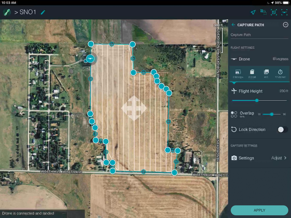
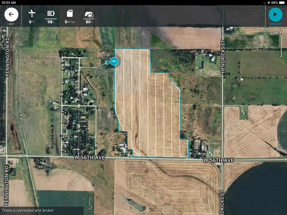
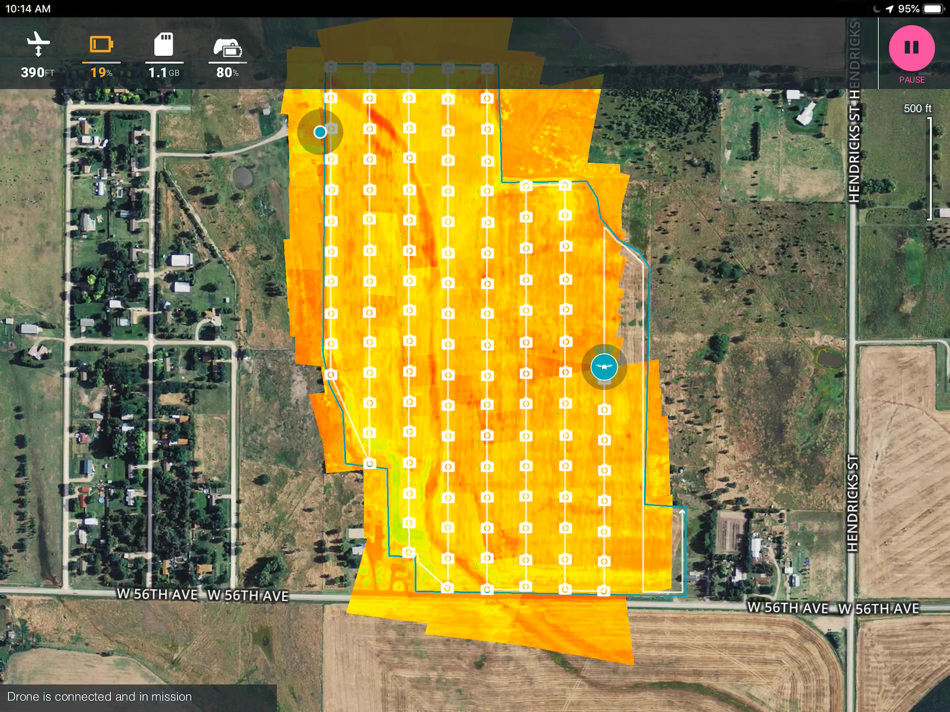
- Enjoy fully automatic flights or fly manually over your crops
- Generate NDVI maps in real-time during the flight
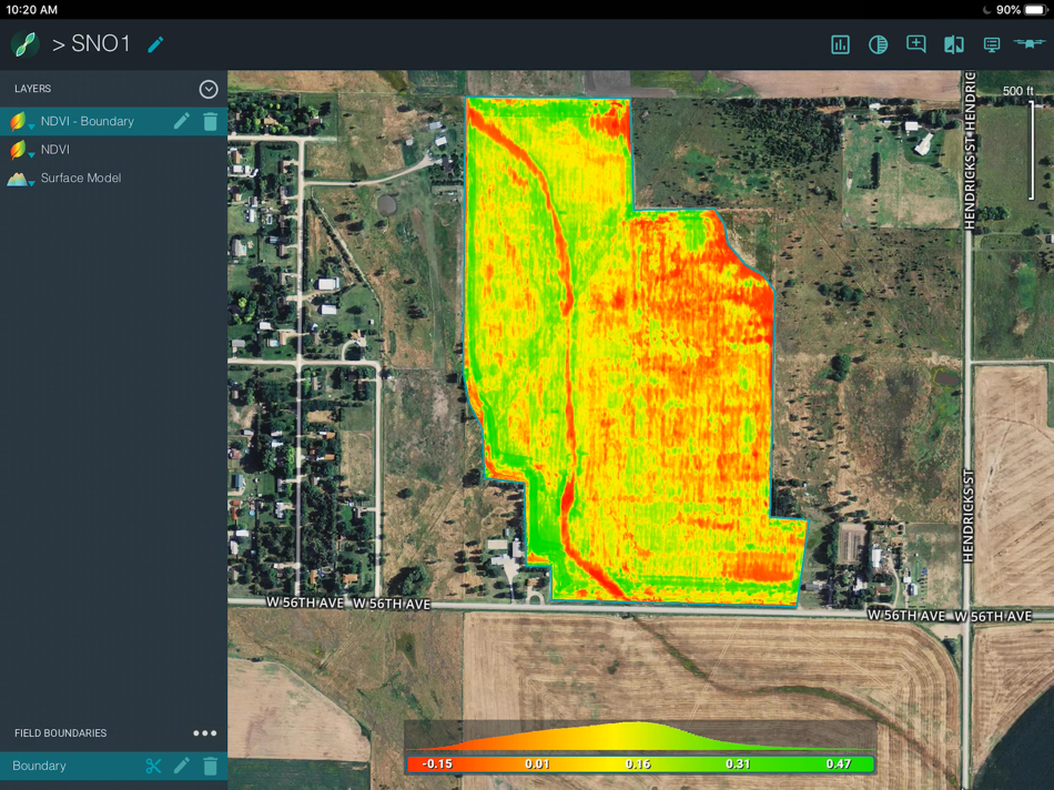
- Compare NDVI maps to monitor the evolution of your crops on your mobile device
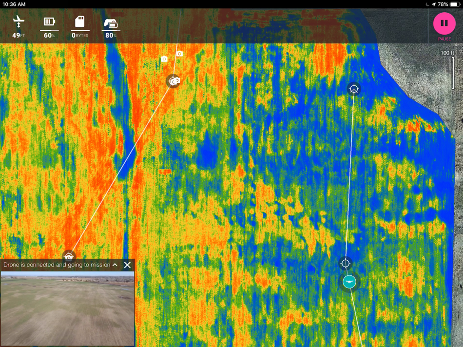
- Explore areas of interest via unique semi-automated scouting flights
- Capture photos and videos on-demand with the Parrot Skycontroller 2
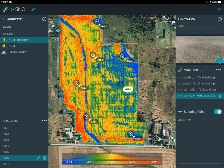
- Add value to the aerial data captured by adding text annotations and shooting photos
with the app directly from the ground.
ParrotFields is a part of the Parrot Bluegrass Fields bundle, the ultimate solution for agriculture.
Parrot Bluegrass Fields includes:
• 1 Parrot Bluegrass quadcopter drone
• 1 Parrot Sequoia multispectral sensor (integrated in drone)
• 1 Parrot Skycontroller 2
• 1 Parrot Skycontroller 2 charger
• 1 backpack
• 3 batteries
• 1 battery charger
• 4 spare propellers
• 1 USB cable for Micro-USB
• One-year subscription to ParrotFields
• One-year subscription to Pix4Dfields (desktop and cloud)
Usage information
Always ensure you have the latest firmware installed on your drone and ParrotFields is up to date.
Use only in safe environments.
ParrotFields can be used in connection with Parrot Bluegrass. However, this is NO WARRANTY of correct functioning, but merely user information.
Disclaimer
Pix4D SA, the publisher of the ParrotFields App, is not a drone manufacturer and does not provide any representation and/or warranty of any sort as to any drone, or any component thereof, or any of their functionality. ParrotFields uses a SDK furnished by the drone manufacturer over which Pix4D SA has no control or direct interaction whatsoever.
ParrotFields instructs the drone to geographically follow a pre-defined flight plan conceived and entered by the user and does neither manage itself the flight procedure of the drone nor avoid itself obstacles automatically. ParrotFields allows users to take back manual control at any time.
ParrotFields takes images automatically, in accordance with the pre-defined options contained within ParrotFields. However Pix4D SA does not warrant the adequacy of framing of the images taken over the fly-zone.
Under no circumstances shall Pix4D SA, and/or any of its affiliates, be responsible for any loss or damage, including personal injury or death, resulting from the use of, or inability to use, ParrotFields with any drone or from the conduct of any users of ParrotFields. In particular, Pix4D SA, and/or any of its affiliates, is not responsible for any problems or technical malfunction of any drone equipment, software, failure due to technical problems or flight planning, including any injury or damage to users or to any person’s computer related to or resulting from, or in connection with, the use of ParrotFields with any drone.
If you are dissatisfied with ParrotFields or any Pix4D terms and conditions, your sole and exclusive remedy is to discontinue using ParrotFields. In addition, you release Pix4D SA and its affiliates from any damages that you incur, and agree not to assert any claims against them, arising from your use of ParrotFields.
螢幕擷取畫面
新功能
- 版本: 1.4.0
- 發佈日期:
- - New: Advanced layer visualization for index and surface model layers
- New: Color selection for annotations (point, line, area)
- Fix: stability improvements and minor bug fixes
價錢
- 今天: 免費
- 最小值: 免費
- 最大值: 免費
追蹤票價
開發人員
- Pix4D
- 平台: Android 應用程式 (1) iOS 應用程式 (2)
- 清單: 0 + 0
- 點數: 5 + 886 ¡
- 排名: 0
- 評測: 0
- 折扣: 0
- 影片: 0
- RSS: 訂閱
點數
0 ☹️
排名
0 ☹️
清單
0 ☹️
評測
成為第一個評論 🌟
其他資訊
聯絡人
- 個人網站:
 https://www.pix4d.com/
- 🌟 分享
- App Store
你可能還喜歡
-
- Fields Area Measure
- iOS 應用程式: 公用程式與工具 由: Asil Arslan
- 免費
- 清單: 0 + 0 排名: 0 評測: 0
- 點數: 0 + 4 (4.0) 版本: 1.2 Field Area Measurement Measure Land & Calculate Area Instantly! Quick & Accurate Land Measurements Easily measure fields, land, and areas with just a few taps! Whether you're a farmer, ⥯
-
- Parrot Recorder - Pro
- iOS 應用程式: 公用程式與工具 由: 天津麦金塔科技有限公司
- $9.99
- 清單: 0 + 0 排名: 0 評測: 0
- 點數: 0 + 2 (1.0) 版本: 1.8.4 Parrot recorder: one-click recording, audio sound player, speech to text, cropping, splicing, transcoding Disguised as an e-book, invisible lock screen is stress-free. Support ... ⥯
-
- Parrot Timer
- iOS 應用程式: 公用程式與工具 由: hidekazu seto
- 免費
- 清單: 0 + 0 排名: 0 評測: 0
- 點數: 0 + 18 (4.8) 版本: 1.0.1 Discover the adorable Parrot Timer app, a delightful timer with a parrot theme. It's designed to add a dash of fun to your time management. Features include: - Engaging visuals where ... ⥯
-
- Fields Area Measure Map
- iOS 應用程式: 公用程式與工具 由: Huy Van
- 免費
- 清單: 0 + 0 排名: 0 評測: 0
- 點數: 0 + 0 版本: 1.0.11 Get data on any section of the globe you need! Find out the perimeter/area/distance of objects of interest to you or just empty plots of land. The Fields Area Measure Map app is a ... ⥯
-
- Angry Parrot Stickers
- iOS 應用程式: 公用程式與工具 由: Paul Scott
- $0.99
- 清單: 0 + 0 排名: 0 評測: 0
- 點數: 0 + 0 版本: 1.0 Set of angry parrot stickers for your iMessage conversations. ⥯
-
- TAP Fields
- iOS 應用程式: 公用程式與工具 由: Topcon Agriculture
- 免費
- 清單: 0 + 0 排名: 0 評測: 0
- 點數: 0 + 1 (5.0) 版本: 1.1.8 TAP Fields allows you to better manage your farm and complex machine activity conveniently and easily from your mobile device. TAP Fields connects to your existing TAP (Topcon ... ⥯
-
- GPS Fields Area Measure Map
- iOS 應用程式: 公用程式與工具 由: Rento UAB
- 免費
- 清單: 0 + 0 排名: 0 評測: 0
- 點數: 1 + 10,579 (4.6) 版本: 2.29.2 Do you own the field and want to place marker, measure the distance, perimeter, or area of it? GPS Fields Area Measure is a free app that allows you to evaluate your fields as you ... ⥯
- 全新
- GPS Fields Area Measure Map +
- iOS 應用程式: 公用程式與工具 由: Milan Savaliya
- * 免費
- 清單: 0 + 0 排名: 0 評測: 0
- 點數: 0 + 1 (5.0) 版本: 1.1 GPS Fields Area Measure: Smart GPS Land & Distance Measurement Want to know the exact size of your land? GPS Fields Area Measure makes it simple. Just tap points on the map to measure ... ⥯
-
- Energy Density of Fields Calc
- iOS 應用程式: 公用程式與工具 由: Nitrio
- $2.99
- 清單: 0 + 0 排名: 0 評測: 0
- 點數: 0 + 0 版本: 1.2 Energy Density of Electric and Magnetic Fields Calculator is a physics/math calculator designed to find energy density quickly and easily. Features: - Instant calculations - Results ... ⥯
-
- GPS Fields Area Measure on Map
- iOS 應用程式: 公用程式與工具 由: SUSAMP INFOTECH
- * 免費
- 清單: 0 + 0 排名: 0 評測: 0
- 點數: 0 + 23 (4.3) 版本: 1.0.17 Measure & Map GPS Land Area is a GPS mapping tool designed to provide users with a convenient & efficient way to measure and calculate land areas. With this measure land area ... ⥯
-
- Pioneer Fields
- iOS 應用程式: 公用程式與工具 由: xFarm Technologies Italia srl
- 免費
- 清單: 0 + 0 排名: 0 評測: 0
- 點數: 0 + 0 版本: 10.2.4 With Pioneer Fields, take your farm to another level: Save Time: Minimize bureaucracy and paperwork. Agronomic Efficiency: Targeted suggestions for defense, irrigation and nutrition. ... ⥯
-
- GPS Fields areas measure
- iOS 應用程式: 公用程式與工具 由: Mykola Kondratiuk
- * 免費
- 清單: 0 + 0 排名: 0 評測: 0
- 點數: 1 + 0 版本: 1.2 The easiest way to measure the land area. Enter the application, turn on the track recording and go around the perimeter of the land, then save the track in kml file for export of the ... ⥯
-
- Bee — The spelling app
- iOS 應用程式: 公用程式與工具 由: Jean-Étienne Parrot
- 免費
- 清單: 0 + 0 排名: 0 評測: 0
- 點數: 0 + 0 版本: 1.0.0 Bee lets you easily spell words. ⥯
- 全新
- S-Remote+
- iOS 應用程式: 公用程式與工具 由: Pamela Fields
- * 免費
- 清單: 0 + 0 排名: 0 評測: 0
- 點數: 1 + 0 版本: 1.0.0 S-Remote+ is a smart and easy-to-use remote control app designed for Smart TVs with Wi-Fi support. It allows you to control your television directly from your iPhone, making it the ... ⥯